Showing posts with label Montana. Show all posts

Saturday, February 4, 2023

12,000 YEAR OLD ROCK ART DATES IN NORTH AMERICA:

Team member taking a pXRF reading at Rochester Creek site, Utah.

The perennial problem of dating petroglyphs may have finally been solved. A team from the Max Planck Institute has used portable X-ray fluorescence equipment (pXRF) to measure levels of elements in the patina in petroglyphs and comparing that to the levels of the same elements in the rock varnish on the unpecked surfaces have come up with seemingly accurate and reliable age estimates for four sites in the northeastern Great Basin of North America. 

Legend Rock site, near Thermopolis, Wyoming.

"Researchers at the Max Planck Institute for Chemistry have now succeeded in applying their non-destructive method to dating rock art in North America. The analysis shows that rock art in the Great Basin, a region in the western U.S., was produced and continuously renewed for twelve millennia. Indigenous people accessed the same artworks over and over again and endowed them with new meaning, the findings show." (Max Planck Institute 2022)

Map Rock Site, Snake River valley, Idaho.

"Rock art originated some 46,000 years ago and can provide unique insights into the minds of our human ancestors. However, dating of these ancient images, especially of petroglyphs, remains a challenge. In this study, we explore the potential of deriving age estimates from measurements of the areal densities of manganese (Dmn) and iron (Dfe) in the rock varnish on pertoglyphs, based on the concept that the amount of varnish that has regrown on a petroglyph since its creation, relative to the surrounding intact varnish, is a measure of its age. We measured (Dmn) and (Dfe) by portable X-ray fluoresence (pXRF) on dated Late Pleistocene and Holocene rock surfaces, from which we derived accumulation rate of Mn and Fe in the rock varnish. The observed rates were comparable to our previous findings on basalt surfaces in North America. We derived age estimates for the rock art at four sites in the northern Great Basin region of North America based on Dmn measurements on the petroglyphs and intact varnish. They suggest that rock art creation in this region began around the Pleistocene/Holocene transition and continued into the Historic Period, encomassing a wide range of styles and motifs. Evidence of reworking of the rock art at various times by indigenous people speaks of the continued agency of these images through the millennia. Our results are in good agreement with chronologies based on archeological and other archaeometric techniques. While our method remains subject to significant uncertainty with regard to the absolute age of individual images, it provides the unique opportunity to obtain age estimates for large ensembles of images without the need for destructive sampling." (Andreae and Andreae 2022)

Celebration Park site, Idaho.

"In the present study, we conducted in-situ measurements by pXRF on petroglyphs at four sites in Idaho, Wyoming, and Montana to determine the areal densities of Mn and Fe in the varnish that had re-accumulated on the rock since its creation. We also made measurements on the intact varnish surrounding the rock (art) to assess the variability of varnish foration between different rock surfaces. We complimented these data by measuring the Mn and Fe densities on rock surfaces of known geological age to obtain varnish accumulation rates. From these results, we derived age estimates for the petroglyphs and evaluate tham within their archaeological and cultural context. Our study extends significantly the very scarce knowledge base on the rate of rock varnish accumulation in semiarid to mesic regions, provides further validation of non-destructive dating technique for rock art, and elucidates the history of rock art creation at four important archaeological sites representing the Great Basin Macrotradition." (Andreae and Andreae 2022)

Celebration Park site, Idaho.

The four sites tested by the Andreaes are; Celebration Park and Map Rock, two petroglyph sites in the Snake River Valley between Twin Falls and Marsing, Idaho; Legend Rock, 35 km northwest of Thermopolis, Wyoming; and Petroglyph Canyon, 21 km northwest of Lovell, Wyoming, just north of the Montana state line. (Andreae and Andreae 2022)

Celebration Park site, Idaho.

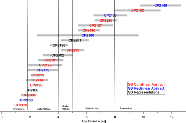
Sites were chosen that had age estimates assigned previously by other methods to allow the team to cross-check their results against previous age estimates. "The diverse rock art spans a broad time period, from the Paleo-Indian era about 15,000 years ago to the recent past. Moreover, the scientists were able to complement their own method with measurements of rock engravings whose ages had previously been dated using independent geochemical methods. Both age estimates were in excellent agreement and thus confirmed each other. The comparison with other archaeological material at the rock art sites, which had been previously dated, also supported the researchers' age estimates." (Max-Planck-Gesellschaft 2022) 


Graph of testing results from Celebration Park site, Idaho.

"'All of our analyses suggest that the earliest petroglyphs were created as early as the transition period from the Pleistocene to the Holocene, about 12,000 years ago, and were repeatedly revised by indigenous people over thousands of years until the recent past,' explains Andreae, a biogeochemist." (Max-Planck-Gesellschaft 2022)

Celebration Park site, Idaho.

If these results hold up through further testing it may be that we have finally achieved at least this one holy grail of rock art research - the ability to date petroglyphs through clues in the patination coating them. Back in the early 80s I made some unsuccessful attempts to do this using a photographic light meter to determine relative darkness of the patina in and ourside of a petroglyph. At roughly the same time Dr. Ronald Dorn was analyzing cation ratios in the varnish to determine the age of petroglyphs, and at that time his method also was not widely trusted and adopted, although I know of instances where his readings successfully matched age estimates for petroglyphs made using other methods. But now we may finally have an inarguable success in dating petroglyphs, and I congratulate the Andreaes' and look forward to their further developments.

NOTE: Some images in this posting were retrieved from the internet with a search for public domain photographs. If any of these images are not intended to be public domain, I apologize, and will happily provide the picture credits if the owner will contact me with them. For further information on these reports you should read the original reports at the sites listed below.  

REFERENCES:

Andreae, Meinrat O., and Tracy W. Andreae, 2022, Archaeometric studies on rock art at four sites in the northeastern Great Basin of North America, 26 January 2022, PLOS, https://doi.org/10.137/journal.pone.0263189. Accessed online 18 August 2022.

Max-Planck-Gesellschaft (Institute), 2022, 12,000-kyear-old rock art in North America, non-destructive method dating petroglyphs in the American West, 28 January 2022, https://mpg.de/18213975/rock-art-petroglyph-dating. Accessed online 17 August 2022.  


Saturday, July 17, 2021

A BOOK REVIEW – “NO BEAR: VISIONS THROUGH TIME.”


Keyser, James D., Carl M. Davis, David A. Kaiser, Mark D. Willis, Stephen J. Lycett, 2021, No Bear: Visions Through Time, Oregon Archaeological Society (OAS) Press, Publication Number 27, Portland, OR.

The 27th volume published by the Oregon Archaeological Society is about a Montana rock art site named the No Bear site. Titled No Bear: Visions Through Time, this volume relates another example of cutting edge recording techniques and analysis of rock art. This site was found on the Blackfeet Reservation in northern Montana, in a nowadays inaccessible location high on a cliff.

View of No Bear petroglyph site, Montana.

No Bear is a small, but complicated site, multi-component in that a number of styles and techniques are represented. “No Bear is located on the Blackfeet Indian Reservation in north-central Montana just east of the Rocky Mountains. The site consists of an extensive and unusual array of red pictographs painted across three adjacent faces on the lower portion of a massive sandstone cliff situated at the confluence of a deep coulee draining into a major stream valley. Petroglyphs are also scratched and abraded across two of the rock faces where they are both superimposed on and superimposed by various pictographs.” (Keyser et al. 2021:2)


    Drawing of panels 1 and 2, No Bear                  petroglyph site, Montana.

Due to the inaccessible location of the rock art the team had to utilize innovative techniques to photograph it in depth. “We initially debated using either a drone or pole-assisted aerial photography (PAP), and after consultation with Mark Willis we brought both types of equipment to the site. Although we used both methods, after examining the site Willis and Keyser decided to rely primarily on PAP photography because of its time-efficiency and accuracy given the site access and weather conditions.” (Keyser et al. 2021:3)


     Detailed drawing of Panel 3, No Bear                petroglyph site, Montana.

The images on these panels were quite difficult to see because of fading and erosion. “In addition to the collapse of a large part of panel 2, significant erosion is evident on the right half of Panel 3, in this area, the painted images are significantly fainter than most others painted on the panel’s left half, making them less visible in ambient light photographs. Some of this is clearly due to age, since several of the fainter images, which are older and thus exposed to more weathering, are scattered among fresher ones. But we also note that photographs show distinctive patterns of abrasion across the right half of the panel and on the extreme lower margin of the panel’s left side.” (Keyser et al. 2021:2-3)

Composite of panels 1, 2, and 3 as photographed, and then DStretched to bring out the pictographs. No Bear petroglyph site, Montana.

“Given the soft slope and weather conditions, we photographed the panels from a range of about 30 cm to 3 meters (1 to 10 feet) and at an elevation of approximately 4 to 6 meters (13 to 19 feet) above stable ground. Willis controlled placement of the camera to take more than 750 photographs while Keyser triggered the shutter at Willis’s direction. – The more than 750 photographs taken by PAP from multiple vantage points in front of the panels allowed Willis to process the photographic data in a commercial Structure from Motion (SfM) photogrammetry package called MetaShape (Version 1.5.3). This software takes a set of overlapping photographs, analyzes the location of visually similar objects in them., and then creates a three-dimensional point cloud (Figures 7, 8) based on the relationship between the objects. The point cloud is a highly accurate 3D representation of the rock art panel surface.” (Keyser et al. 2021:5)

To make the images visible the team processed the resulting 3D model with D-stretch. “During and ofter preparing the composite photograph, DStretch enhancements of many individual photographs were used to emphasize the painted imagery for purposes of photo-tracing. This also helped highlight the scratched petroglyphs.” (Keyser et al. 2021:7)

 All in all approximately eight pages are used to explain their recording methods in detail, highly educational for others seeking a recording model.  The subsequent sixty pages are devoted to the in-depth analysis we would expect from this team. Every detail of every panel is studied, identified, and compared with other examples from the region to try to find its significance.

From the shape of feathers on a headdress to the weapon, or dance wand, displayed in a figure’s hand, this analysis happens, comprehensive and in-depth, and it has allowed the team to make a number of important conclusions. "All three panels have pictographs, and differences in weathering combined with superimpositions indicate that artists painted images in at least four different episodes on Panel 3. Other artists using Panel 3 also scratched and/or abraded a series of petroglyphs in at least three different episodes occurring between the two major painting episodes. One artist also drew a small scratched oval scrawl on the large anthropomorph in Panel 1. In all, we have identified at least seven different episodes of rock art production at the site." (Keyser et al. 2021:11)

The final product is not only an in-depth analysis of a fascinating and unique rock art site, but also is an example of detailed thoroughness and excellence for future rock art researchers and recorders.

For more information about this, and their other publications go to www.oregonarcheological.org/publications or inquire at Oregon Archaeological Society, PO Box 13293, Portland, Oregon, 97213.

Saturday, June 2, 2018

BOOK REVIEW - HORSE RAIDERS IN THE MISSOURI BREAKS:


It wasn't done by the butler in the library . . . . . it was done in the Missouri Breaks, by the Blackfoot and the Crow.


Cover: Horse Raiders in the Missouri
Breaks,  Keyser and Minick, 2018,
Oregon Archaeological Society,
Portland.

Back in the dim past (1970s and 80s) when I was only a few years into my studies of rock art, I was lucky enough to meet Jim Keyser, the only archaeologist I know who had the courage at that time to state that we could, in fact, interpret rock art and learn a lot about it and the people who made it, not just record it. Since then, Jim's publications with a number of collaborators, provide an education in how to approach the subject of meaning in rock art. Now I have the distinct pleasure of presenting to you a 2018 book by James D. Keyser, and David L. Minick, Horse Raiders in the Missouri Breaks: Eagle Creek Canyon Petroglyphs, Montana, another volume in the series published by the Oregon Archaeological Society in Portland (www.oregonarchaeological.org).


Eagle Creek Canyon Petroglyphs
site, 24CH757, Montana.


Stylistic comparisons,
Fig. 12, p. 22.

Most rock art books are large regional surveys or site reports, but this is an in-depth analysis of the rock art of a single locale, but (as with all of Keyser's work) with a very broad range of comparative material explaining and establishing it in time and place. It includes very detailed descriptions of the rock art, and comparisons to ledger-book art as well. Including over 100 pages on just six panels at a single site (just five panels if you discount panel three which is a modern autograph - vandalism), its detailed chronologic and stylistic classification will inform studies over a much broader region, and its approach to the study of rock art sets an example that we can all benefit from. For example: it includes eight pages (31 - 38) of analysis of saddles in rock art. I also count forty pages devoted to interpretation of the rock art at the site.


Jim Keyser with a recording crew, 
Eagle Creek Canyon project.

From his beginnings in rock art studies Keyser has  propounded the theory that Native American winter counts and ledger book art provide a lexicon that we can use to inform our analysis of rock art imagery. Over his productive career Keyser has also accumulated comparative files of other rock art sites which join the winter counts and ledger book art in his lexicon of examples. This analysis, based on Keyser's huge comparative files, also places it in the broader context of regional rock art, and Native American art which could be applied to other art forms and media.


Plate 5, Horse, Carved and 
abraded on Panel 5.

David Minick is a long-time member of Oregon Archaeological Society and member of Keyser's rock art research team. His profession was Photo-journalist and Photographer and for the last 5 -6 years he has done much of their camera work specializing in DStretch analysis, along with lab work. He has also co-published some site reports with Keyser from Oregon, Washington, and Utah, especially recovering imagery with DStretch.


Plate 2, Horse and rider
from Panel 2.

This partnership has combined their talents to illustrate an example for the way rock art sites should be approached. As a result of their extensive analysis the authors have developed an explanation of the presence of the rock art being studied as an ancient form of tagging, or calling cards. Back on March 13, 2011, I posted a column titled Tagging and Territorial Marking in Rock Art, looking at the question as to whether some rock art was the equivalent of the modern form of vandalism - tagging. The idea is that it is a mark left by someone for someone else to find, not quite in the sense of "Kilroy was here," but more in a challenging sense, like "I was here and there was nothing you could do about it." Keyser and Minick have, of course, provided a much more thorough explanation of rock art as a "calling card."

In their analysis the examples of Blackfoot and Crow rock art in the same location are successive messages from one group to the other, taunting them. In their theory the basic motive was the Plains Indian phenomenon of horse raiding, stealing horses from an enemy group. This site, Eagle Creek Canyon in Montana, they present as being located in the area bordering between both tribes and on a natural route for horse raiding. If my group was successful I might leave a horse image on the cliff to taunt you, and after a reciprocal raid your group might leave a horse image there to trump mine.
Five Star Book.

This volume provides a lesson as to how rock art analysis should be conducted. It can be ordered from the Oregon Archaeological Society at
http://www.oregonarchaeological.org/publications/

REFERENCE: 

Keyser, James D., and David L. Minick,
2018 Horse Raiders in the Missouri Breaks: Eagle Creek Canyon Petroglyphs, Montana, Oregon Archaeological Society, Portland. www.oregonarchaeological.org

Saturday, November 11, 2017

A NEWLY-FOUND MONTANA GEOGLYPH:


Anthropomorphic geoglyph, Henry
Smith Site, Montana -  Photograph
U.S. Bureau of Land Management,
Public domain.

On September 22, 2010, I posted a column titled A GEOGLYPH IN SOUTHEAST COLORADO - THE MAN WITH THE SPEAR, about a rock alignment in the form of a human figure found near Two Buttes in southeastern Colorado. (Faris 2010)  Now an article in Westerndigs.org by Blake DePastino revealed a Montana geoglyph that is very similar. A 2015 grass fire at the Henry Smith site burned off enough cover that this geoglyph, and a number of other features, could be recorded.


The intentional grass fire, Henry
Smith Site, Montana -  Photograph
U.S. Bureau of Land Management,
Public domain.

The newly discovered features include another large figure that appears to represent a turtle, six rock cairns, and a large number of drive lines. The Henry Smith site was previously known and has been interpreted as a buffalo jump (Miller 2015) and bison hunting camp, but many of these features were not recorded until their discovery after the fire.

Radiocarbon dating of bison remains from at least six discrete layers established that the site was in use from between 770 to 1040 CE, and stemmed stone points found there place the people who used it within the Middle and Late Avonlea Phases from the Northern Plains. Partial excavation in the 1960s revealed a portion of the impoundment where the driven animals were trapped. (DePastino 2017)


Stone circles seen from drone, Henry
Smith Site, Montana -  Photograph
U.S. Bureau of Land Management,
Public domain.

The fire was purposely set in mid-April and covered approximately 320 acres. After the fire exposed the features they were extensively photographed from a drone. Also discovered were a number of stone circles. A few of these were tipi rings, but others may have been a type of medicine wheel.(DePastino 2017) Study of the site will continue.

NOTE: Images in this posting were retrieved from the internet after a search for public domain photographs. If any of these images are not intended to be public domain, I apologize, and will happily provide the picture credits if the owner will contact me with them. For further information on these reports you should read the originals at the sites listed below.

REFERENCES:

DePastino, Blake
2017 Fire Reveals Human Stone Effigy, Bison-Kill Site in Montana, February 5, 2017, http://westerndigs.org/fire-reveals-human-stone-effigy-bison-kill-site-in-montana/

Faris, Peter
2010 A Geoglyph in Southeast Colorado - The Man With The Spear, September 22, 2010, http://rockartblog.blogspot.com/search?q=A+GEOGLYPH+IN+SOUTHEAST+COLORADO+-+THE+MAN+WITH+THE+SPEAR%3A

Miller, Mark
2015   Montana Burn Reveals Ancient Stone Effigies, Cairns, Rock Formetions, and Buffalo Slaughter Areas, May 30, 2015, http://www.ancient-origins.net/news-history-archaeology/montana-burn-reveals-ancient-stone-effigies-cairns-rock-formations-020369?nopaging=1

Sunday, January 31, 2016

HISTORIC INSCRIPTIONS - GEORGE A. CUSTER, 1873:


George A. Custer, 1873.
From Urbaniak, 2015.

On December 27, 2009, I posted a column on ROCK ART OF THE LITTLE BIGHORN in which I presented a couple of rock art panels which have relations to the battle of the Little Bighorn in 1876, the so-called Custer Massacre.

In his 2014 thesis for the University of Montana titled HISTORIC INSCRIPTIONS OF THE NORTHERN PLAINS IDENTITY AND INFLUENCE IN THE RESIDUAL COMMUNICATION, Timothy Urbaniak has included an inscription of George A. Custer, although apparently we cannot relate it to the Little Bighorn battle. This inscription can, however, be associated with the 1873 Yellowstone Expedition/Northern Plains Railroad Survey.

"The Yellowstone Expedition of 1873 was an expedition of the United States Army in the summer of 1873 in Dakota Territory and Montana Territory, to survey a route for the Northern Pacific Railroad along the Yellowstone River. The expedition was under the overall command of Colonel David S. Stanley, with Lieutenant Colonel George A. Custer second in command." (Wikipedia)


1873 Yellowstone Expedition
map. Public domain.

"During the summer of 1873, troops under the command of Colonel David S. Stanley, Lieutenant Colonel G. A. Custer, 7th Cavalry Detachment, Lieutenant Colonel Luther P. Bradley, 8th and 9th Infantry Battalion, Major Robert E. A. Crofton, 6th and 17th Infantry Battalion, and Charles J. Dickey, 22nd Infantry Battalion, accompanied surveyors of the Northern Pacific Railroad under the leadership of Thomas L. Rosser, Engineer in Chief in an expedition to examine the Northern Plains landscape along the Yellowstone and Musselshell Rivers in the Montana Territory for the purpose of potential railway routing (Eckroth 2013:13). Toward the close of that Expedition, Lieutenant Colonel Custer remained with the surveyors as they left the Musselshell River and navigated east to rendezvous with Colonel Stanley, who had taken another route." (Urbaniak 2015:120-1)


Portrait of George Armstrong
Custer, 1873, St. Louis Missouri,
Wikimedia.org.

"During this process it became apparent that an inscription reading "George A. Custer 1873" (Figure 5.35) was adjacent to the plotted route. Although the GPS location of the inscription is several miles to the north of the route mapped by the railroad surveyors, it is well within the viewshed of the thousands of people and associated traveling wagons, horses, and livestock that accompanied the expedition. The inscription certainly is not in an area that would lend itself to "being carved to promote tourism," and if the intent was to attract attention, it may have been more neatly inscribed. It is interesting that the inscription does not include a group association with a military unit, a common communication behavior shown to occur elsewhere. Other faint lines on the sandstone surface may indicate that it was superimposed over a petroglyph figure. In addition to the proximity to the mapped trail of the 1873 Yellowstone Expedition, anecdotal support from the sparsely populated locals maintain that the inscription has been known to have been there since first viewed by early immigrants (Jim Meyers 2012, elec. comm.)." (Urbaniak 2015:121)

I am personally somewhat surprised that this inscription has survived un-vandalized, given the approbation that the name George A. Custer arouses among most Native Americans. Not that I would condone vandalism in any way. My personal opinion is that having a historic inscription of the name George A. Custer, serves as a reminder of how badly we once behaved toward the original inhabitants of the area, and may, perhaps, prompt us to do better by all people in the future.

NOTE: Once again I wish to thank Timothy Urbaniak for permission to use material from his thesis. Good work Tim, and thank you.

REFERENCES:

Urbianik, Timothy Rostov,
2014    HISTORIC INSCRIPTIONS OF THE NORTHERN PLAINS IDENTITY AND INFLUENCE IN THE RESIDUAL COMMUNICATION, Dissertation Presented in partial fulfillment of the requirements for the degree of Doctor of Philosophy in Anthropology The University of Montana, Missoula, MT,  July 2014.


Wikipedia

Saturday, January 16, 2016

HISTORIC INSCTIPTIONS - GENERAL CROOK, 1876:


"G. Crook, 1876", inscription.
Photo:Urbaniak, 2014.

I have mentioned this inscription in two previous postings (to view them click on the General Crook entry in the cloud index at the bottom of the blog) but only from field drawings as I did not have an actual photo of it. Now I can present a photograph of the General Crook inscription courtesy of the previously cited (Tom Horn, 12/11/2015; Kid Curry) 2014 thesis dissertation of Timothy Urbaniak, HISTORIC INSCRIPTIONS OF THE NORTHERN PLAINS IDENTITY AND INFLUENCE IN THE RESIDUAL COMMUNICATION . Tim has generously allowed me to reproduce some of his illustrations of historic inscriptions and quote his text.

"From 1875 to 1882 - Crook was head of the Department of the Platte. Crook served against the Sioux during the Great Sioux War of 1876-77. He fought the Lakota at the Battle of the Rosebud. On 28 May 1876, Brigadier General George Crook assumed direct command of the Bighorn and Yellowstone Expedition at Fort Fetterman." (Wikipedia)


General Crook, Wikimedia.

Crook left Fort Fetterman the next day with over 1,000 troops consisting of "15 companies from the 2nd and 3rd Cavalry, 5 companies from the 4th and 9th Infantry, 250 mules and 106 wagons. On 14 June, the column was joined by 261 Shoshone and Crow allies." (Wikipedia)


"The Battle of the Rosebud," from
Frank Leslie's Illustrated Newspaper,
1876, public domain.

On 17 June, during a rest break, the troops heard gunfire from the north and a scout rushed into the camp shouting, "Lakota, Lakota" and the Battle of the Rosebud was beginning. "By 0830, the Sioux and Cheyenne had hotly engaged Crook's Indian allies on the high ground north of the main body. Heavily outnumbered, the Crow and Shoshone scouts fell back toward the camp, but their fighting withdrawal gave Crook time to deploy his forces. Rapidly firing the soldiers drove off the attackers but used up much of the ammunition meant for use later in the campaign. Low on ammunition and with numerous wounded, the General returned to his post. Historians debate whether Crook's pressing on could have prevented the killing of five companies of the 7th Cavalry Regiment led by George Armstrong Custer at the Battle of the Little Bighorn." (Wikipedia)


"G. Crook, 1876", inscription
highlighted. Photo:Urbaniak, 2014.

"At the Rosebud Battlefield there is a long sandstone cliff line that was once used as a buffalo jump and that has provided a canvas for communication for millennia. Petroglyphs dating to precontact times, primarily in the form of shield figures, are incised along the surface of the sandstone cliff. The surface also contains historic inscriptions including one of "G. Crook 1876" (Figure 5.40); since the incising is shallow, it has been traced for clarity (Figure 5.41). Due to the fact that it takes time to create an inscription, even such a shallow one, and due to the fact that the Rosebud Battle began in the morning and just a few hours after Crook and his men arrived at Rosebud Creek, there was not likely a lot of time for a pre-battle incising, and there is no mention of the act in Crook's autobiography (Crook 1986:194). It is possible that someone else carved it as a commemoration; or Crook created he inscription when he returned to the site in the 1890s; although if that was the case he did not spend much in the effort." (Urbaniak 2014:122-3)

So, is this inscription attributable to General Crook? Well, if in the sense of did General Crook carve it himself, I do not think we can answer that. But, if in the sense of was it carved by someone else when General Crook was there (in the general vicinity) I think that is very likely. In either case it brings back a fascinating period of Western History - thank you Tim.

REFERENCES:

Urbianik, Timothy Rostov,
2014    HISTORIC INSCRIPTIONS OF THE NORTHERN PLAINS IDENTITY AND INFLUENCE IN THE RESIDUAL COMMUNICATION, Dissertation Presented in partial fulfillment of the requirements for the degree of Doctor of Philosophy in Anthropology The University of Montana Missoula, MT,  July 2014.


Wikipedia

Saturday, January 9, 2016

HISTORIC INSCRIPTIONS - KID CURRY, 1901:


Another illustration from the PhD
thesis of Timothy Urbaniak (2014)
identifies "Kid Curry, 1901."

"While inscriptions of "outlaws" have been documented further south into Wyoming, evidence of them roaming eastern Montana is scarcer, with the exception of the inscription "Kid Curry 1901" (Figure 5.77), located on a lone sandstone outcrop north of Ingomar, Montana." (Urbaniak 2014:130)

"Kid Curry came to Montana when he was about 16 and eventually started a ranch south of Landusky with his brothers. But when a feud erupted and Curry shot Pike Landusky, owner of the brothers’ favorite saloon, Curry skipped town for Wyoming." (Tribune Staff 2014)
 
The Wild Bunch, Logan is on
the right in the rear, public
domain photograph.

In Wyoming "he joined a gang of bandits led by “Flat-Nosed” George Currie (no relation) and Harry Longabaugh, alias the “Sundance Kid.” George Parker, alias “Butch Cassidy,” later joined the gang, eventually known as the Wild Bunch. The group’s legendary robberies include a bank hold-up in Belle Fourche, S.D., and Union Pacific train robberies." (Tribune Staff 2014)

"On July 3, 1901, Kid Curry and the Wild Bunch pulled off one of the most successful train robberies in U.S. history. At Exeter Creek, about six miles west of Malta, they held up the Great Northern Railway passenger train. They disappeared with $41,500 in unsigned tender. 
No one was ever convicted for the Great Northern robbery, but Kid Curry was arrested later that year in Tennessee for forging bank notes — presumably from the same train heist. 
He was sentenced to 41 years in prison but escaped in 1903." (Tribune Staff 2014)

The 1901 inscription of Kid Curry at Ingomar, Montana, would likely have been carved before the July 3, 1901 train robbery because, afterward the gang (including Kid Curry) would have been concentrating on evading the law. Indeed, if you are being chased by a posse, or just sought by Pinkerton agents, you are not likely to leave your name carved on a rock to give a clue towards where you had gone. Urbaniak concluded that the inscription was connected with the train robbery. "It has been speculated that the inscribing is connected with a trip to rob the Great Northern train near Wagner, Montana, which he did on July 3, 1901." (Urbaniak 2014:130)


Harvey Logan, AKA Kid Curry,
public domain photograph.

"Curry’s later activities are debated, but Nate Murphy, curator of Outlaw Lawmen Collections at the Phillips County Museum, said the most reliable information comes from the Pinkerton detective agents who trailed the Wild Bunch’s crime spree. Their records say Curry’s corpse was identified in Colorado. He was wounded in 1904 during a gunfight after a botched train robbery in Parachute, Colo. To avoid being captured, he shot himself in the head." (Tribune staff 2014) Kid Curry was buried in Linwood Cemetery, in Glenwood Springs, Colorado (Doc Holliday is also buried there).

Although the popular movie Butch Cassidy and the Sundance Kid glamorized the details of the gang's activities, including train robberies, we will do well to remember that these were violent acts and innocent people were injured and killed.


Linwood Cemetery, Glenwood Springs, Colorado. http://www.tripadvisor.com/

Such historic inscriptions can provide us with a direct emotional and intellectual link to events of the past, to the deeds and circumstances that have led to our society today. Indeed, I have been to Parachute and Glenwood Springs, Colorado, many times, and I have even ridden the train through them. I love these historic inscriptions because of such feelings of connection, and the way they allow us to better  understand the history of who we are and where we live.

.  .  .  .  .  .  .  .  .  .  .  .  .  .  .  .  .  .  .  .

NOTE: This material is presented through the generosity of Tim Urbaniak, who compiled much of this material for his 2014 PhD thesis, HISTORIC INSCRIPTIONS OF THE NORTHERN PLAINS IDENTITY AND INFLUENCE IN THE RESIDUAL COMMUNICATION RECORD at the University of Montana, in Missoula.


REFERENCES:

Staff, Great Falls Tribune, 2014.

Urbianik, Timothy Rostov,
2014    HISTORIC INSCRIPTIONS OF THE NORTHERN PLAINS IDENTITY AND INFLUENCE IN THE RESIDUAL COMMUNICATION, Dissertation Presented in partial fulfillment of the requirements for the degree of Doctor of Philosophy in Anthropology The University of Montana Missoula, MT,  July 2014.

Wikipedia.

www.tripadvisor.com

Saturday, September 13, 2014

COUP COUNTS IN ROCK ART – RIFLES:


Painted Rifles, Farrington Springs, at the canal, Bent
County, CO. Photo Peter Faris, October 1990.

One type of coup that conferred high honor on a Plains Indian warrior was earned by capturing his enemy’s weapons, rendering him helpless. This is sometimes depicted in rock art as one or more vertical weapons in a composition. In many instances rows of vertical weapons represent a number of coups counted in this manner by a warrior, or perhaps a group of warriors. At the amazing rock art site of Farrington Springs in southeast Colorado a faded row of eight painted rifles can be seen as an example of this. This might be the record of a warrior who counted eight of these coups in his career, or illustrate the weapons captured as the result of a battle by a whole group of warriors. 

“No gathering or ceremony took place without a series of coup counts, or public listing in individual’s famous deeds. These coup counts served to honor dedicated and industrious members of society, to inspire children to emulate the leaders, and to present a strong and unified appearance to enemies. – Some rock art in the black hills country – like much historic Plains Indian art – records the accomplishments of individual warriors.” (Sundstrom 2004:99)

“In this biographical art tradition, as it has sometimes been termed, every element included in a drawing conveys meaning. Hairstyle is often a clue to the subject’s tribal identity. Personal attire may indicate his social status or warrior society membership. Shield designs or a distinctive article of clothing might indicate the personal identity of the individual pictured. A bow or a gun indicates weapons captured or used to touch the enemy.” (Sundstrom 2004:100)


Linnea Sundstrom, Storied Stone: Indian Rock Art in
the Black Hills Country, 2004, Fig. 9.17, p. 111.
Rifles circled by me.

On December 27, 2009, I posted a column entitled ROCK ART OF THE LITTLE BIGHORN about a rock art panel in the Black Hills which Linea Sundstrom suggests might represent coup counts after the battle of the Little Bighorn. Sundstrom described it as follows: “At the bottom of the panel are four long rows of sketchy human figures. Their position indicates that they were “taken,” that is, killed. Because part of the panel is missing, it is impossible to make an exact count, but more than 200 must have been in the drawing before weathering erased some figures.” Rows of guns are included in the composition suggesting a large number of captured weapons as part of the same event. “At the left end of the top row of corpses is an eagle like that seen on U.S. Army insignia. Because no single Indian ever killed that many U.S. soldiers, this count must represent a collective event of killing – probably the battle of the Little Bighorn.” (Sundstrom 2004:110) In this panel 26 captured rifles are illustrated.


Rifles, Pictograph Cave, Billings, Montana.
Photograph 1982, Jack and Esther Faris.


Rifles, Pictograph Cave, Billings Montana.
Photograph August 24, 2008, Peter Faris.
Retouched image from signage at the site.

At the site of Pictograph Cave, south of Billings, Montana, there is another tally count of rifles much like the other examples. Seven rifles in a row are displayed above a row of 23 short lines like tally marks. The rifles and the short tally lines seem to be painted with the same pigment which may mean they are indeed related. Possibly the 23 tally marks are shorthand for 23 more rifles giving us a total of thirty weapons captured in coups or recovered from the battlefield. If we assume that this is indeed another coup count it is tempting to try to also connect it to the Battle of the Little Bighorn because of the close geographic proximity of this site to the battlefield. As can be seen in the illustration of the detailed reconstruction of the panel all seven rifles are firing which suggests a battle context. The rifles are pictured in a style which suggests older flintlock muzzle loading weapons but in this case that could just be a stylistic decision, indeed some of the guns used by the Lakota and Cheyenne warriors were reportedly still muzzle loading and this design was so recent in history that all of them would recognize the meaning of the portrayals.

REFERENCES:

Faris, Peter
2009    Rock Art of the Little Bighorn, in http://rockartblog.blogspot.com, Dec. 29.

Sundstrom, Linea

2004   Storied Stone: Indian Rock Art in the Black Hills Country, University of Oklahoma Press, Norman.