Showing posts with label drive line. Show all posts

Saturday, July 27, 2024

STONE BLINDS AND DRIVELINES REVISITED – BALTIC SEA ‘BLINKERWALL':

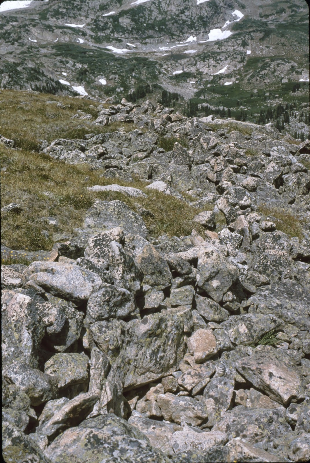
Rollins Pass Driveline, Grand County, CO.,1 mi. of fence, 174 pit blinds & 184 cairns, ca. 6,000 - 3,000 BC, Photograph Peter Faris,  25 July 1987.

One interesting facet of the study of geoglyphs is the fact that many of them are connected to hunting in some way. Some are just simple hunting blinds where the hunter can be concealed while waiting for prey. Some are complex traps for prey, and some are meant to influence the movement of the animals in such a way that benefits a waiting hunter. This last seems to be the case for the recently discovered wall under the Baltic Sea.

Back on 14 February 2015 I published” Stone Blinds and Drivelines – Rollins Pass, CO.” on RockArtBlog, about visiting the vast stone drivelines and hunting blinds on Rollins Pass in the Colorado Rockies with Doctor James Benedict, the noted high mountains archaeologist. Most of the drive lines are now only one or two stones high, any animal could easily step over them, but apparently they are still doing the job today that they were constructed for long ago. “Dr. Benedict stated that one day during one of his recording trips to the site he watched a deer or elk wandering up the slope stop and divert to the side when it came to one of the drive lines, even in their modern broken down and aggraded condition.” (Faris 2015) Apparently their effectiveness depends on the artificial appearance of a straight line in the natural environment. Benedict had estimated that more than a mile of stone walls remain on that location.
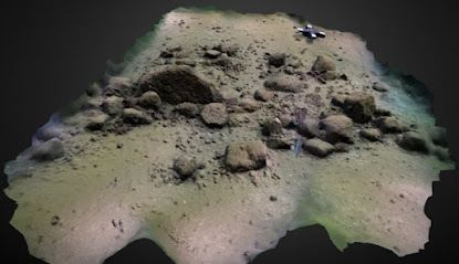
3-D model of the west end of the Blinkerwall. Image by Phillipp Hoy, Rostock University, Rostock, Germany.

Now, in 2021, such a construction has been located under the Baltic Sea dating back to before the rise in sea levels at the end of the glaciations period, estimated to be roughly 11,000 years ago there.

“In 2021, Jacob Geersen, a geophysicist with the Leibniz Institute for Baltic Sea Research in the German port town of Warnemünde, took his students on a training exercise along the Baltic coast. They used a multibeam sonar system to map the seafloor about 6.2 miles (10 kilometers) offshore. Analyzing the resulting images back in the lab, Geersen noticed a strange structure that did not seem like it would have occurred naturally. Further investigation led to the conclusion that this was a manmade megastructure built some 11,000 years ago to channel reindeer herds as a hunting strategy. Dubbed the "Blinkerwall," it's quite possibly the oldest such megastructure yet discovered, according to a new paper published in the Proceedings of the National Academy of Sciences—although precisely dating these kinds of archaeological structures is notoriously challenging.” (Ouellette 2024) The assumption is that it functioned with the local reindeer exactly like Dr. Benedict (above) related for the Rollins Pass drive lines. The reindeer would divert and follow the fence to a location where the hunters waited in ambush.

The Blinkerwall, the oldest structure in the Baltic Sea. Illustration by Michal Grabowski.

“The discovery is made up of more than 1,300 stones and roughly 300 larger boulders, and it stretches for more than half a mile along the seafloor. Resting nearly 70 feet underwater in the Bay of Mecklenburg, the wall stands, on average, about 1.5 feet tall. Natural events, such as glacial deposits or other land movements, cannot account for this structure’s existence, researchers report in a study published Monday in Proceedings of the National Academy of Sciences. Instead, they argue, the roughly 11,000-year-old wall was a tool built by hunters to guide and trap reindeer, which tend to travel along straight elements of the landscape, such as cliff sides or streams. ‘Hunters tapped into the natural behavior of the animals and created their own linear feature,’ Ashley Lemke, an underwater archaeologist at the University of Wisconsin-Milwaukee who was not involved with the research, tells Science’s Andrew Curry. ‘It’s not an obstruction, it’s a trail. They follow it to where the hunters are waiting.” (Thorsberg 2024) This preceding description is a very good explanation of how and why such drivelines work.

Scan of the west end of the Blinkerwall.

"'At this time, the entire population across northern Europe was likely below 5,000 people. One of their main food sources were herds of reindeer, which migrated seasonally through the sparsely vegetated post-glacial landscape. The wall was probably used to guide the reindeer into a bottlenick between the adjacent lakeshore and the wall, or even into the lake, where the Stone Age hunters could kill them more easily with their weapons,' explains Marcel Bradtmoller from the University of Rostock. The last reindeer herds vanished from these regions approximately 11,000 years ago due to climate warming and forest expansion. Consequently, the stone wall was probably not constructed after this period. If this is accurate, it would classify the wall as the oldest human-made structure ever found in the Baltic Sea." (Waters 2024)

The animals are diverted along the construction by its very existence on the site, ending up exactly where the waiting hunters want them to be for maximum advantage in harvesting game. Since reindeer migrate in large groups the harvest could have been quite large, illustrating the effectiveness of such a tactic.


Detailed structure of the Bay of Mecklenburg including the location of the Blinkerwall. Bathymetric data from The Federal Maritime and Hydrographic Agency Bundesamt für Seeschifffahrt und Hydrographie (BSH).

The only other possible explanation for this wall (other than it being a drive line) was what the authors (Geersen et al.) call ‘stone fishing.’ “In the absence of basal complexes and basement rocks in Northern Germany, glacially derived stones were used for construction purposes in this area toward the end of the last millennium. The demand for stones resulted in the birth of stone fishing as a profession. Stone fishing represents an anthropogenic effort to move and conquer boulders from the marine environment using stone pincers and ropes. -  After 1906, stone fishing was prohibited, and the stones were left in place being identified as important habitat and also useful for coastal protection. Because stone fishing (had) concentrated on the near-coastal waters and was not done in the central basins, we consider an anthropogenic movement of the stones for the purpose of stone fishing an unlikely candidate to explain the construction of the Blinkerwall. Furthermore, it seems unlikely that within the 18th and 19th century, stone fishers would have been able to place the stones next to each other over a distance of about 1 km given the water depth of about 21 m. Let alone the fact that their intention was to remove the stones rather than place them elsewhere on the seafloor.” (Geersen et al. 2024)

So, logically, the fact that the wall is now under 21 meters of water and that it was constructed by humans, the most likely explanation for it is that it was constructed when that area was still dry land, which dates it to the end of the last Ice Age. A very impressive accomplishment for people back then, and an impressive job of deduction for the authors (Geersen et al. 2024) of the report.

NOTE 1: Some images in this posting were retrieved from the internet with a search for public domain photographs. If any of these images are not intended to be public domain, I apologize, and will happily provide the picture credits if the owner will contact me with them.

NOTE 2: I have not included secondary citations in the References (below). For further information on these reports and all sources you should read the original reports at the sites listed below.


REFERENCES:

Faris, Peter, 2015, Stone Blinds and Drivelines – Rollins Pass, CO., 14 February 2015, https://rockartblog.blogspot.com.

Geersen, Jacob, Marcel Bradtmoller, Jens Schneider von Deimling and Harald Lubke, 2024, A submerged Stone Age hunting architecture from the Western Baltic Sea, 12February 2024, PNAS, Vol. 121, No. 8, https://www.pnas.org. DOI.org/10.1073/pnas.231008121. Accessed online 20 May 2024.

Ouellette, Jennifer, 2024, Scientists found a Stone Age megastructure submerged in the Baltic Sea, 14 February 2024. Proceedings of the National Academy of Sciences 2024, DOI: 10.1073/pnas.2312008121, https://arstechnica.com. Accessed online 17 February 2024.

Thorsberg, Christian, 2024, Stone Age Wall Discovered Beneath the Baltic Sea Helped Early Hunters Trap Reindeer, 13 February 2024, https://www.smithsonianmag.com. Accessed online 17 February 2024.

Waters, Conny, 2024, Underwater Drone Images Reveal Oldest Human-Made Structure In The Baltic Sea, 13 February 2024, https://ancientpages.com. Accessed online 14 February 2024.

Saturday, June 22, 2024

ANOTHER UNDERWATER DRIVELINE – THE DROP 45 SITE IN LAKE HURON:

About a utilitarian geoglyph for hunting animals.

North American Laurentide ice sheet. Illustration from Pinterest.
Laurentide ice sheet, Illustration from smithsonianmag.com.
Map of the Cordilleran and Laurentide ice sheets. Online image, public domain.

It is easy to overlook, or forget, that the glacial periods had so much water locked up in ice that considerably more territory was available to prehistoric humans. Not only at continental margins, but where large lakes now exist, land was exposed and, no doubt, lived on and utilized by the populations. With the last melting of glacial ice this water was released and raised water levels considerably. This means, of course, that many traces of prehistoric life and activities are now underwater.

“Some of the most pivotal questions in human prehistory necessitate the investigation of archaeological sites that are now under water. The advance and retreat of glacial ice throughout the period of human development and dispersal, and the associated global changes in sea level, repeatedly exposed, and then submerged, significant coastal land masses. As a result, questions as diverse as the origins of early human culture, the spread of hominids out of Africa, and the colonization of the New World all hinge on evidence that is under water. Although the discovery and investigation of such sites presents methodological challenges, these contexts also have unique potential for preserving ancient sites without disturbance from later human occupation. The Alpena-Amberley Ridge (AAR) beneath modern Lake Huron in the North American Great Lakes provides just such a setting.” (O’Shea, et al. 2014:6911)

Diagram of Drop 45 Site beneath Lake Huron. Illustration from O'Shea et al., 2014.

During the last glaciations, before the birth of the Great Lakes, paleoIndian hunters roamed the area and left traces of their existence. “Since 2008, more than 60 stone constructions on the AAR have been identified and visually inspected within two targeted research areas. Targets of potential interest identified during acoustic survey are examined via video provided by a remote operated vehicle (ROV) and, if warranted, are directly mapped and sampled by self-contained underwater breathing apparatus (scuba)-trained archaeologists.” (O’Shea, et al. 2014:6911) These investigations are now made possible by the development of the new technologies.

Blinds and drive lines seen from above. Drop 45 Site beneath Lake Huron. Illustration from O'Shea et al., 2014.

“Underwater archaeologists have discovered evidence of prehistoric caribou hunts that provide unprecedented insight into the social and seasonal organization of early peoples in the Great Lakes Region. An article detailing the discovery of a 9,000-year-old caribou hunting drive lane under Lake Huron appears in today’s issue of the Proceedings of the National Academy of Sciences. ‘This site and its associated artifacts, along with environmental and simulation studies, suggest that Late Paleoindian/Early Archaic caribou hunters employed distinctly different seasonal approaches,’ said John O’Shea, the Emerson F. Greenman Professor of Anthropological Archaeology and lead author of the article. ‘In autumn, small groups carried out the caribou hunts, and in spring, larger groups of hunters cooperated.” (Swanbrow 2014)

Rollins Pass drive line, Grand County, Colorado, 25 July 1987, 1 mile of fence, 174 pit blinds and 184 cairns, ca. 6,000 - 3,000 BC. Photograph Peter Faris, 1987.

Although a low stone wall could have been easily crossed by the game animals, the appearance of such artificial features on the landscape seemingly make the animal uneasy, they tend to turn aside and parallel such a wall instead of crossing over. The high-altitude Rocky Mountain archaeologist James Benedict once told me about watching a deer approach a linear stone feature on Rollins Pass in the Colorado Rockies. Although the stone line is basically only one stone high nowadays the deer turned aside instead of crossing it. (Benedict, Personal communication, 1987)

Diver recording a hunting blind, Drop 45 Site beneath Lake Huron. Illustration from O'Shea et al., 2014.

Drop 45 Site beneath Lake Huron. Illustration from O'Shea et al., 2014.
Diver and underwater drone. Drop 45 Site beneath Lake Huron. Illustration from O'Shea et al., 2014.

“Researchers based at the University of Michigan think the roughly 9,000-year-old structure helped natives corral caribou herds migrating across what was then an exposed land-corridor – the so-called Alpena-Amberly Ridge – connecting northeast Michigan to southern Ontario. The area is now covered by 120 feet (37 meters) of water, but at the time, was exposed due to dry conditions of the last ice age.” (LiveScience Staff 2014)

“Paleoenvironmental analysis indicates that the area was a subarctic environment consisting of sphagnum moss, tamarack larch and spruce trees, along with small lakes, rivers, and wetlands. Radiocarbon dates on preserved wood yielded dates from 8,900–8,640 cal B.P., whereas charcoal recovered from the middle of a circle of small stones yielded a date of 9,020 cal B.P. The environment that emerges from these studies is one that would have been ideal for migrating caribou and for their human pursuers”. (O’Shea, et al. 2014:6911) I find it remarkable that we even have these hard dates for these features. Wonderful work.

NOTE: Some images in this posting were retrieved from the internet with a search for public domain photographs. If any of these images are not intended to be public domain, I apologize, and will happily provide the picture credits if the owner will contact me with them. For further information on these reports you should read the original reports at the sites listed below.


REFERENCES:

Benedict, James, 1987, Personal communication.

LiveScience Staff, 2014, In Photos: Hunting Structure Hidden Beneath Lake Huron, 28 April 2014, https://www.livescience.com. Accessed online 6 May 2024.

O’Shea, John M., et al., 2014, A 9,000-year-old caribou hunting structure beneath Lake Huron, Proceedings of the National Academy of Science (PNAS), 13 May 2014, Vol. 111, No. 19, 6911-15. Accessed online 6 May 2024.

Swanbrow, Diane, 2014, Prehistoric caribou hunting structure found beneath Lake Huron, 28 April 2014, https://record.umich.edu. Accessed online 6 May 2024.

Saturday, February 14, 2015

STONE BLINDS AND DRIVELINES - ROLLINS PASS, CO:


Drive line, Rollins Pass, Grand County, CO.
Photograph Peter Faris, 25 July 1987. 

Over the years I have discussed features that we classify as geoglyphs a few times. Under our western cultural classifications of art we have always included architecture so I feel that I can properly include rock constructions under the classification of rock art. In this posting I want to mention the amazing rock alignments and constructions on the top of Rollins Pass in Grand County, Colorado at 11,671’ altitude in the Colorado Rocky Mountains. I have had the opportunity to visit there a couple of times, the first in 1987 with Dr. James Benedict who researched high altitude archaeology for many years and was certainly the expert on the Rollins Pass alignments.


A section of the drive line, Rollins Pass, Grand County,
CO. Photograph Peter Faris, 25 July 1987.

These comprise 12 game drives and associated stone hunting blinds and other features. “Several drives are small, perhaps single construction episode walls containing less than 150 meters of rock alignments, while others are large, likely aggraded drives, which contain over 1500 meters of drive features much like other game drives in the Indian Peaks such as Sawtooth Mountain and the Arapaho Pass System.” (Pelton 2012:55)


Close-up of stone construction, Rollins Pass, Grand
County, CO. Photograph Peter Faris, 25 July 1987.

At the time of my first visit to the area in 1987, Dr. Benedict gave a rough estimate of over 1 mi. of fence, 174 pit blinds, and 184 cairns, and gave his date estimates as from ca. 6,000 - 3,000 BC. Obviously people had expended a great deal of time and energy to create these features in the thin air of nearly 12,000 feet above sea level.

“Six of the 12 sites contain less than 500 meters of rock alignments, three contain between 500 meters and one kilometer, two contain between one and two kilometers of rock alignments, and one contains over two kilometers (2,041 meters) of rock alignments. In terms of the total number of pit or hunting blind features, seven sites contain one to ten, two sites contain 11 to 20, two contain between 30 and 40, and one contains over 40.” (Pelton 2012:55)


 Hunting blind, Rollins Pass, Grand County, CO.
Photograph Peter Faris, 25 July 1987.

The hunting blinds may have been partially excavated pit features which were then surrounded by a rock wall that the hunter could conceal behind as the animals were driven toward them. Excavations in hunting blinds have proven that people were indeed in them, at least on occasion, as dropped items and tool sharpening flakes have been reported.

We can only surmise how exactly they were used, but I can easily imagine a group of hunters gathering in some of the blinds on top of the pass while the rest of the clan hikes down to lower altitude in the forest. There they could spread out in a long line and begin a noisy drive up towards the pass on top, driving any animals ahead of them and funneling them toward where the hunters waited. In such a scenario the Rollins Pass complex would function as sort of the reverse of a buffalo jump. In this case instead of driving the game to fall down, they were driving them to climb up, but the results would have been much the same.

A view of the summit of Rollins Pass and the modern road across it seen from within one of the hunting blinds shows a section of drive line couple of the cairns visible as longer rocks standing on end. The landscape in the back ground gives a good idea of the altitude and the conditions found here.


View from within a stone blind of the drive line, Rollins Pass,
Grand County, CO.photograph Peter Faris, 25 July 1987.
Cairns represented by vertical rocks in right center.

“The number of cairns per site is most often related to a specific design element of certain game drives - in which cairn alignments are utilized in the place of rock wall alignments, a construction technique that requires far less labor investment and exhibits no discernible pattern, in terms of cairn quantity, between sites. Based on the numbers from the 12 previously recorded game drives, the “average” game drive at Rollins Pass contains around 670 meters of rock alignments, between 15 to 16 pit or hunting blind features, and between 9 to 10 cairns.” (Pelton 2012:55-56)

These cairns most probably were similar to the inuksuk built by Inuit hunters to help guide the reindeer to a desired hunting ground. How effective could such a complex be? Dr. Benedict stated that one day during one of his recording trips to the site he watched a deer or elk wandering up the slope stop and divert to the side when it came to one of the drive lines, even in there modern broken down and aggraded condition.

As rock alignments, and very impressive ones at that, these drive line complexes certainly classify as a category of geoglyphs, and as we consider architecture to be one component of the arts, I feel completely justified in including these in RockArtBlog.

REFERENCE:

Pelton, Spencer R.
2012    Putting Rollins Pass on the Map: Revitalizing the Research of a High Altitude Archaeological Landscape, pages 54-57, Colorado Archaeology, Spring 2012, Vol. 78, No. 1, Colorado Archaeological Society and Colorado Council of Professional Archaeologists.