Showing posts with label geoglyphs. Show all posts

Saturday, May 10, 2025

GEOGLYPHS OF THE BLACK DESERT OF JORDAN:


Black Desert geoglyphs, Jordan. Image from News Jordan.

A series of very interesting geoglyphs stretch across a volcanic wasteland known as the Black Desert of Jordan. I was made aware of these when I received a communication from Tomás Tarjuelo Palomino, a collaborator introducing me to the theories of Spanish researcher Mrs. Virtudes Pontes Sánchez who has been studying the geoglyphs. In the following paragraphs I will present the geoglyphs and then go into the theory of Mrs. Sánchez and Mr. Palomino in a separate column.

These geoglyphs have occasionally been lumped into the same category as the ‘desert kites (see Note 1 below)’ that I have written about previously. This should not be accepted, however, as the ‘desert kites’ are obviously traps for hunting antelope and the purposes of these particular geoglyphs are unknown, but none of them seem to have a shape that would function as an effective animal trap. I purposely wrote the previous sentence as plural, purposes, because the patterns of internal walls, entrances and other construction details are far from standardized. Were they residences, temples, tombs or fortifications, or all of the above, nobody seems to know.

Black Desert geoglyphs, Jordan. Image from News Jordan.

There have been attempts to explain these constructions as archerastronomical sites. "Researchers have also shown that, in the past, one cluster of the wheels could have been linked with astronomical knowledge and that some of the geoglyphs were probably connected with burials." (Archaeology World Team) This is an example of the phenomenon known as confirmation bias, wherein an answer that was correct before for a different question is given outsized weight when applied to the current question. Just like everything looks like a nail to a hammer, everything likes like archeoastonomy to an archeoastronomer.


Black Desert geoglyphs, Jordan. Google Earth image from the Daily Mail, UK.

“It has been concluded by archaeologists that at least two of the giant Wadi Al Qattafi ‘Wheels’ from Wadi Al Qattafi and the Wisad Pools, in the Black Desert of Jordan are at least 8,500 years old – making them older than the famous Nazca Lines in Peru by about 6,000 years.” (Archaeology World Team) These must be among the oldest human constructions in the region. “BBC reports that by using optically stimulated luminescence (OSL), the archaeologists were able to show not only the date of creation of the two wheels but also that one of them was repaired about 5,500 years ago.” (Archaeology World Team) These dates would have been achieved by OSL dating of the soil just under a rock providing a date for the last time sunshine shone on that patch of ground.

Azraq Wheels geoglyph, Black Desert, Jordan. Reddit image.

“The research, soon to be published in the journal Antiquity, demonstrates that at the time of the creation of these two wheels the climate of the Black Desert would have been very different, making life in the area easier.” (Archaeology World Team) These do not provide us an answer for what any of the desert constructions actually were used for. They are, however, a very strong argument that at least two of them were not archeoastronomical.

Azraq Wheels geoglyph, Black Desert, Jordan. Reddit image.

As I wrote above, the fact that no two of these constructions seem to have been built to the same pattern suggests that they may have had varied purposes. One suggestion I would like to make is that seen from above many of them look like a small, fortified hamlet or farmstead, with an outer wall, either for defense or to fence in livestock, and inner subdivisions representing animal pens and, presumably, areas for the construction of residential structures. Perhaps the differences in size and complexity are because of differences in group size and economic status. The larger structures might represent a clan or extended family and its large herds, while the smaller ones may just be a multi-generational residence with smaller flocks.

In my next column, I am going to pass along the absolutely unique, and highly creative, theory the the aforementioned Tomás Tarjuelo Palomino, and Spanish researcher Mrs. Virtudes Pontes Sánchez

NOTE 1: So-called ‘Desert Kites’ have been mentioned in two previous columns on RockArtBlog.

29 July 2023, 9,000 Year Old Petroglyphs Copy Designs of Mega-Scale Desert Animal Traps. https://www.blogger.com/blog/post/edit/7760124847746733855/8126054377764858401.

17 June 2023, Editorial on the Use of Artificial Intelligence in Rock Art Analysis. https://www.blogger.com/blog/post/edit/7760124847746733855/1059986807197980559.

NOTE 2: Some images in this posting were retrieved from the internet with a search for public domain photographs. If any of these images are not intended to be public domain, I apologize, and will happily provide the picture credits if the owner will contact me with them. For further information on these reports you should read the original reports at the sites listed below.


REFERENCES:

Archaeology World Team, 2019, These Mysterious in Jordan Are 6,000 Years Older Than Peru’s Nazca Lines, 17 December 2019, https://archaeology-world.com. Accessed online 9 February 2025.

Tomás Tarjuelo Palomino, 24 January 2025, Personal Communication.

Virtudes Pontes Sánchez, 2021, Groundbreaking Archaeological and Scientific Discovery in the Jordanian Black Desert, 1 October 2021, https://operationdisclosureofficial.com. Accessed online 9 February 2025.


Saturday, January 13, 2024

STONE CIRCLES OF SENEGAMBIA:

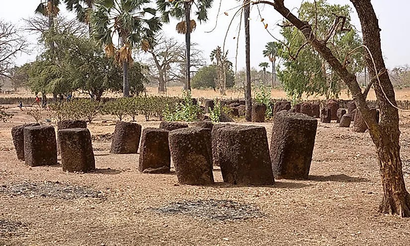
Stone circles of Senegal and Gambia, Africa. Online image, public domain.

There is a remarkable collection of stone circles and related monuments along the River Gambia in Gambia and Senegal in Western Africa. “The site consists of four large groups of stone circles that represent an extraordinary concentration of over 1,000 monuments in a band 100 km wide along some 350 km of the River Gambia. The four groups, Sine Ngayene, Wanar, Wasu and Kerbatch, cover 93 stone circles and numerous timuli, burial mounds, some of which have been excavated to reveal material that suggest dates between 3rd century BC and 16th century AD. Together the stone circles of laterite pillars and their associated burial mounds present a vast sacred landscape created over more than 1,500 years. It reflects a prosperous, highly organized and lasting society.” (UNESCO)

Stone circles of Senegal and Gambia, Africa. Online image, public domain.

Stone circles of Senegal and Gambia, Africa. Online image, public domain.

The comparative effort involved in the construction of these would seem to rival the creation of pyramids in Egypt or Moai on Rapa Nui (Easter Island). One can imagine whole segments of the society spending most of their time laboring on this huge complex of stone circles. “The stones forming the circles were extracted from nearby laterite quarries using iron tools and skillfully shaped into almost identical pillars, either cylindrical or polygonal, on average around 2 m in height and weighing up to 7 tons. Each circle contains between eight to fourteen standing stones having a diameter of four to six metres. The four megalithic sites inscribed bear witness to a prosperous and highly organized society with traditions of stone circle constructions, associated with burials, and persisting in certain areas over more than a millennium.” (UNESCO)

Stone circles of Sine Ngayene, Africa. Online image, public domain.

Sine Ngayene: “Sine Ngayene is the largest of the four areas, and home of 52 stone circles, one double circle, and 1,102 carved stones. It is generally accepted that the single burials found here predate the multiple burials that are associated with the construction of the stone circles. The site of Sine Ngayene is located just northwest of Sine, Senegal. In 2002, an expedition was launched in the Petit-Bao-Bolong drainage tributary; it was called Sine- Ngayene Archaeological Project (SNAP). The team found iron smelting sites and quarries located close to the monument sites. They also found evidence of hundreds of homes nearby, dating around the time of the monuments, clustered in groups of 2 – 5 with remnants of house floors and pottery shards. This evidence suggests the existence of small, linked yet independent communities. Researchers also suggest the possibility that these megalithic cemeteries could have been a focal spot of the cultural landscape and served the purpose of bringing people together.” (Wikipedia)

Stone circles of Wanar, Senegal, Africa. Online image, public domain.

Wanar: “The area of Wanar is located in the Kaffrine district of Senegal, and is made up of 21 stone circles and one double circle. – All of the monuments found at Wanar seem to mark burials, according to the archaeologists working there. Researchers have also determined that the site was a burial ground first, and the stones were added later for ritual use. Construction for this area can be narrowed down to between the seventh and fifteenth centuries A.D.

A current dating program that has begun is yielding estimates that date the construction of the double circle to between the twelfth and thirteenth centuries. A 2008 excavation was conducted on the double circle at Wanar, and two types of burials were distinguished: simple burials that consisted of large pits sealed with a mound, and more complex burials that were deep with narrow mouths. There was also a presence of perishable materials found in the burials, such as brick and plaster, that suggests the existence of funerary houses built at the time of burial.” (Wikipedia)

Stone circles of Wassu, Africa. Online image, public domain.

Stone circles of Wassu, Africa. Online image, public domain.

Wassu: “Researchers are not certain when these monuments were built, but the generally accepted range is between the third century B.C. and the sixteenth century A.D.” (Wikipedia)

Stone circles of Kerbatch, Gambis, Africa. Online image, public domain.

Kerbatch: “Kerbatch, an area comprising nine stone circles and one double circle, is located in Gambia’s Nianija district. Kerbatch features a V-shaped, ‘bifid’ stone (the only one in the region) that had broken in three places and fallen. This stone, that had been part of a frontal line, was restored during the 1965 Anglo-Gambian Stone Circles Expedition led by P. Ozanne. During thes expedition Ozanne and his team excavated the double circle at Kerbatch.” (Wikipedia) These are listed as the major concentrations although there are a number of other monuments and stone circles.

“During the medieval period of Europe which corresponds roughly to the Golden Age of West Africa, several great empires and kingdoms sprang out from the Senegambia region, including but not limited to the great Ghana Empire, the Mali Empire, the Songhai Empire, the Jolof Empire, the Kaabu Empire, the Kingdoms of Sine, Saloum, Baol, Waalo and Takrur. During this period several great dynasties rose and fell, and some, such as the Guelowar Dayasty of Sine and Saloum, survived for more than 600 years despite European colonialism, which fell as recently as 1969, nine years after Senegal gained its independence from France.” (Wikipedia) In the eurocentric world view that we have inherited we tend to forget that other cultures reached surprising heights long before our culture developed. Not only the scale and magnitude of these monuments attests to the cultural height of these kingdoms, but also their other arts and cultural advancements.

“The integrity of the four components of the site can only be evaluated as part of a much wider unified cultural complex. The complexes conserve their integrity in terms of spatial associations of the component circles, individual megaliths and tumuli. The spiritual beliefs associated to the stones by local communities help protect their integrity. The stone circles stand in a farmed landscape and there have been few interventions. A very small number of stones have been removed. Some burial sites have been excavated and subsequently back-filled. These disturbances remain minimal. The oval authenticity of the four sites is intact.” (UNESCO) It seems a little awkward to me to refer to “100 km wide along some 350 km” in length as a site – singular – but later the plural sites is used.

These stone circles represent a notable cultural accomplishment, attesting to a high level of civilization whose greatness deserves to be preserved and remembered.

NOTE: Some images in this posting were retrieved from the internet with a search for public domain photographs. If any of these images are not intended to be public domain, I apologize, and will happily provide the picture credits if the owner will contact me with them. For further information on these reports you should read the original reports at the sites listed below.

REFERENCES:

UNESCO, Stone Circles of Senegambia, https://whc.unesco.org/en/list/1226. Accessed on 12 February 2023.

Wikipedia, Senegambian stone circles, https://en.wikipedia.org/wiki/Senegambian_stone_circles. Accessed on 12 February 2023.

Wikipedia, Senegambia, https://en.wikipedia.org/wiki/Senegambia#Media. Accessed on 17 February 2023.

Sunday, October 9, 2022

FORT MOJAVE TWINS GEOGLYPH ALIGNMENT:

Mojave Twins Geoglyph, Arizona. Internet photograph public domain.

Back in August 2022 I received an interesting letter. Lee Knutson wrote of a discovery he had made on Google Earth. Lee discovered alignments related to the Fort Mojave Twins Geoglyphs which are fenced off on the Fort Mojave Tribal reservation.

Figure 1, Google Earth at an elevation of ~22 miles, this line is indicated in gold; the general location of the geoglyphs. Knutson 2022.

A number of internet souces purport to enlighten us about the pair of geoglyphs known as the Mojave Twins, but since they are mostly identical and represent copies of a single source we must take anything they say with a large dose of salt. "The Mojave Twins - - are two of about 120 intaglios along the Colorado River from northern Mexico to Fort Mojave. The Mojave Twins have been said to represent a spiritual form of good and evil. One twin has a large round head and attached limbs, the second has a shortened head and detached arms, the second twin likely representing evil. The more complete twin appears to represent Mustamho, the name given to the creator God by the Mojaves according to the reference book 'Earth Figures of the Lower Colorado' by Boma Johnson. The sacred Avikwaame Mountain and the original river homeland of the Mojave are visible from the Twin's location, on a high terrace located on the Fort Mojave Indian land (seen best from an airplane)." (fathersmanifesto.net) The above paragraph seems to be one of the sources of the copies of information found on the internet about the Fort Mojave Twins geoglyphs.

Figure 2, Mojave Twins Geoglyph, Arizona. Knutson 2022.

Knutson included a number of illustrations including screen shots from his computer and explained his findings as follows: "Using Google Earth, a line on heading of ~279 degrees can be drawn between the Boundary Cone Butte (Mojave: Avi-Veskwi), a prominent outlier of the Black Mountains of Arizona on the eastern side of the Mojave Valley, and Mt. Manchester (Mojave: Avi-Mota), the high point of the Dead Mountains on the western side of the colorado River. In Figure 1, an annotated screenshot from Google Earth at an elevation of ~22 miles, this line is indicated in gold; the general location of the geoglyphs is indicated by a blue star." (Knutson 2022)

"Close up in Figure 2, from an elevation of 286 feet, a section of that line in black (A) is tangential to the top of the more northerly figure, and bisects the 'cleared area' on the western margin." (Knutson 2022)

"A green line (B), bisecting the torso of the (headless) northerly figure, and projected to the point of the right elbow of the larger figure, has a heading of ~200 degrees south. Finally, a red line (C) bisects the larger southerly figure, from a point between the feet of the northerly figure to the crown, and has a heading of ~212 degrees south." (Knutson 2022)

"The geoglyph site straddles the line between the two peaks: this placement is not accidental, and the crossing of the 'cleared area' shows that. In fact, all the elements and aspects of the site ought to be considered purposefully placed and interrelated. While the location of the geoglyphs takes advantage of the unique location between the peaks, the orientations of the figures could have been in any direction that would fit the site. As it is, the headings of figures are downriver, to the south and west, and separated by ~12 degrees. From the ground level, these point toward the Sacramento Mountains, west of Needles, California. Recalling, howeever, that the geoglyphs are scaled for viewing from above, it seems reasonable to look for some association." (Knutson 2022)

Figure 3, Alignments to Milky Way shown with Stellarium. Knutson 2022.

"Using Stellarium (Zotti 2021), the Milky Way appears on the horizon at civil twilight on the Fall Equinox at a heading of ~200 degrees and approximately one month later it can be seen again at civil twilight on the horizon at a heading of ~212 degrees." (Knutson 2022)

"Figure 3 is a combination of images from Stellarium and Google Earth, reoriented to a south-southwest horizon: the appearance of the Milky Way is mapped to the two headings of the figures. Note that this appearance, immediately after sunset, only occurs at this time of the year." (Knutson 2022)

Do I know what these alignments might imply, what meaning (if any) was intended? No, I do not. Lee does not try to interpret them either. "My intention is to simply report these findings, and not to speculate on meanings or ultimate  purposes."(Knutson 2022) I appreciate the fact that he does not go out on some fringe limb about archaeoastronomy, but lets the facts speak for themselves. Thank you for sharing Lee, and keep up the good work.


NOTE: Stellarium is a free, open-source astronomy planetarium software available at stellarium.org. Google Earth is a free program that provides views of the surface of the earth, available at https://earth.google.com. Images in this column were provided by Lee Knutson, and are used with his permission.

The quotation of Boma Johnson from fathersmanifesto.net could not be confirmed with Johnson. Boma Johnson passed away in 2019: see obit @ https://dixierockart.com/boma-johnson.

PRIMARY REFERENCES:

Knutson, Lee, 2022, personal communication.

https://fathersmanifesto.net/intaglio.htm

SECONDARY REFERENCES:

Johnson, Boma, 1986, Earth Figures of the Lower Colorado and Gila River Deserts: A Functional Analysis, 1 January 1986, Arizona Archaeological Society, Phoenix.

Zotti, George, and Alexander Wolf (editors), 2021, Stellarium 0.21.0 User Guide, https://github.com/Stellarium/stellarium/releases/download/v.0.21.0/stellarium_user_guide-0.21.0.pdf

Saturday, September 18, 2021

PERU'S PALPA GEOGLYPHS:


Palpa geoglyphs, Paracas culture, Peru. Internet image.


  Close-up, Palpa geoglyphs, Paracas culture,                   Peru. Internet image.

Everyone interested in rock art knows about the Nasca geoglyphs in Peru, but not everyone knows of the geoglyphs around the nearby town of Palpa which are considered to be centuries older, created by the fascinating Paracas culture.


Palpa geoglyphs, Paracas culture, Peru. Internet image.

“The valleys of Palpa and Nasca share a combined cultural history, with the Palpa area of the Nasca basin containing geoglyphs and linear features that are comparable in quality and complexity to the concentration of lines and geoglyphs on the Nasca desert plains (pampas).

To differentiate the two ‘Nasca geoglyphs’ is used to denote all pre-Hispanic ground carvings in the Nasca drainage, whilst the ‘Palpa geoglyphs’ refers to the subset of geoglyphs located in the area around the present-day town of Palpa.


  Close-up, Palpa geoglyphs, Paracas culture,                   Peru. Internet image.

It is speculated that the Palpa geoglyphs derive from the period of the Paracas culture (800 BC – 100 BC), the precursor to the evolution of the Nasca culture (100 BC – AD800), that are both distinguished by their unique associated ceramics and textiles.” (Heritage Daily 2021)  

  Close-up, Palpa geoglyphs, Paracas culture,                   Peru. Internet image.

There are some apparent differences however. The Nasca lines and shapes are generally on the reasonably flat surface of the Nasca Plain and are not generally believed to be intended to be seen in their entirety from ground level observers. Also most of them are just lines and/or geometric shapes. Many scientists speculate that the Nasca geoglyphs are there for humans to interact with by walking the lines. The Palpa geoglyphs, however, are apparently fantasy anthropomorphs and zoomorphs predominantly, and they are placed on hillsides and slopes so they can be seen and comprehended from the ground level, perhaps ancestors or deities watching over the village.


“The Palpa geoglyphs were mainly position(ed) on sloped terrain near the Rio Grande basin or the Palpa alluvial plain, which allowed the geoglyphs to be seen from a distance. Hardly a trace of use has been associated, making it difficult to theorize their purpose or function in Paracas culture, in marked contrast to later geometric geoglyphs of the Nasca culture.” (Heritage Daily 2021)


Palpa geoglyphs, Paracas culture, Peru. Internet image.

They appear to be more for observing than for interacting with. So, although they are all geoglyphs in the same general region, their meaning and intended purpose must have drastically changed over the intervening centuries.

Another difference is seen in the technique used to create the images. “The early figures were made by removing dark stones from lighter sediments. But, unlike later geoglyphs, the removed stones were not only used for marking the outline of the geoglyph, but were also piled up to form the mouth, eyes, or other anatomical features.” (Heritage Daily 2021)

  Close-up, Palpa geoglyphs, Paracas culture,                   Peru. Internet image.

Also, the Nasca geoglyphs are all relatively simple. Most of them are large but simple geometric figures and lines, even the portrayals of animals are, for the most part, simple outlines. The Palpa geoglyphs, on the other hand, are quite a bit more complex with body details in-filled and ornate headdresses, accessories and decoration.

NOTE: Images in this posting were retrieved from the internet with a search for public domain photographs. If any of these images are not intended to be public domain, I apologize, and will happily provide the picture credits if the owner will contact me with them. For further information on this you should read the original reports at the site listed below.

REFERENCES:

Archaeology News, 2021, The Mysterious Palpa Geoglyphs, #139923, August 2021, Heritage Daily, https://www.heritagedaily.com

Saturday, February 29, 2020

NEW NAZCA GEOGLYPHS DISCOVERED:


New geoglyph discovered
near Nazca,
Credit Yamagata University.

A team from Yamagata University has announced the discovery of 143 new geoglyphs at Nazca, Peru. A paper by Dr. Masato Sakai explained that "The Yamagata University Institute of Nasca was founded in October 2012 in the City of Nasca, Peru. It is the only research group in the world that the Peruvian government gives a permission to conduct on-site field study in the long run. Yamagata University is playing the central role in conducting international collaborative research with the group of specialists in anthropology, archaeology, geography, psychology, information science, conservation science, zoology and chronology." (Sakai)  Sakai was part of the team that also recently identified the species of some of the bird geoglyphs at Nazca which I wrote about on August 10, 2019, and August 17, 2019 with Avian Subjects Identified In Nazca Geoglyphs: Part One - The Hummingbird and the second article Avian Subjects Identified in Nazca Geoglyphs: Part Two - The Others!


Diagram of the new geoglyph
discovered near Nazca,
Credit Yamagata University.

This was made possible by the founding of the Yamagata University Institute of Nasca in October 2012 in the city of Nasca, Peru. "It is the only research group in the world that the Peruvian government gives a permission to conduct on-site field study in the long run." (Sakai)

Researchers have used a number of new technologies in this search. They have used aerial photography from drones as well as airborne laser detection. Perhaps most interesting and important, one of the figures they discovered was actually recognized by analyzing their images with artificial intelligence (AI).


Geoglyph discovered by Watson,
Credit Yamagata University.

"We analyzed high-resolution images of the entire Nas(c)a Pampa, obtained through aerial laser measurements among other methods, and conducted fieldword in the area, 'the researchers said. Through these efforts, we constructed a hypothesis that a thype of biomorphic geoglyph was chiefly produced along some paths situated in the western region of the Pampa.'" (Sci-News 2019)

They have now made a number of major discoveries of unknown geoglyphs. "Archaeologists at the Japanese University of Yamagata report that a long-term study conducted since 2004 has uncovered 143 previously unknown Nazca gdoglyphs, including a figure who escaped human detection and (was) discovered by artificial intelligence." (ScienceNews)

The scientists divided the new geoglyphs into two categorized based on the techniques of their original creation. This also implied two different age groupings of the figures.

"They are categorized into two main types, depending on whether the geoglyphs were made by removing stones to form lines (type A) or to form solid-colored surfaces (type B). Type A geoglyphs date relatively later and were likely created in the Early Nazca period (100 CE to 300 CE). On the other hand, the type B geoglyphs were produced at least during the Initial Nazca period (100BCE to 100CE), if not earlier." (Sci-News 2019)

This may be the first reported instance in which artificial intelligence has aided in rock art-related research and shows it to have great potential in the long run.


Diagram of the geoglyph
discovered by Watson,
Credit Yamagata University.

"The team also used the IBM Watson Machine Learning Community Edition (formerly known as IBM Power AI) to analyze images of the Naz(c)a Pampa and find candidates for new biomorphic geoglyphs. 'We selected a promising candidate from the results and conducted fieldwork at the area in 2019,' the archaeologists said. 
'This led to the discovery of one new figure in the west of the Nazca Pampa. This figure is relatively small, spanning about 16 feet (5m) across, and depicts a humanoid figure standing on two feet. It was likely created during the Initial Nazca period, as it is a type B geoglyph produced by removing stones to form a a solid-colored shape. This newly discovered figure was also situated near a path, indicating that it was likely used as a kind of waypost.'" (Sci-News 2019)

This last sentence somewhat confused me as the way I first read it I thought it meant that Watson used the presence of the path as a clue to look for something in the near vicinity, after re-reading it I have decided that the writer meant it to indicate that the figure may have been intended by its Nazca creators as a waypost/landmark along the path.

I find this report really exciting, the addition of Artificial Intelligence as a tool to locate and record rock art would be an additional possibility and a powerful future tool for preservation, study, and interpretation. I can hardly wait.

NOTES: 1. In quoting from published material I have generally used the spelling of Nazca or Nasca used by the authors. However, in the quotations from Sci-News I corrected a few that were spelled Nasza.

2. Some images in this posting were retrieved from the internet with a search for public domain photographs. If any of these images are not intended to be public domain, I apologize, and will happily provide the picture credits if the owner will contact me with them. For further information on these reports you should read the original reports at the sites listed below.

REFERENCES:

Greshko, Michael
2018 Exclusive: Massive Ancient Drawings Found in Peruvian Desert, April 5, 2018, https://www.nationalgeographic.com/news/2018/04/new-nazca-lines-discovery-peru-archaeology/

Sakai, Masato, Ph.D,
undated     World's Only Research Team on Nasca Lines and Geoglyphs, https://www.yamagata-u.ac.jp/en/research/highlights/lit1/

Science News Staff,
2019 More than 140 new Nazca geoglyphs have been discovered, November 20, 2019, https://scientistsstudy.com/2019/11/more-than-140-new-nazca-geoglyphs-have.html

Sci-News Staff
2019 Archaeologists Discover 143 New Nazca Geoglyphs, November 25, 2019, http://www.sci-news.com/archaeology/new-nazca-geoglyphs-07836.html

Saturday, August 17, 2019

AVIAN SUBJECTS IDENTIFIED IN NAZCA GEOGLYPHS: PART TWO – THE OTHERS!

Last week I began a two-report on a recent paper from the Journal of Archaeological Science: Reports titled “Identifying the Bird Figures of the Nasca Pampas: An Ornithological Perspective” by Masaki Eda, Takeshi Yamasaki and Masato Sakai. Now we will look at some more of their conclusions.


BG-4c, Fig. 4c, identified as a parrot
hatchling. Internet, Public Domain.


Parrot hatchling,
abc.net.au.

“Geoglyph BG-4c (Fig. 4c) was listed as a duck (Lumbreras, 2000). The bill is short and thick, and almost as thick as the head. There is a raised portion on the forehead and an irregular circle at the center of the body trunk. If this feature represents a wing, the birds’ upper limbs are quite short. One short leg is recognizable; it is attached to a wide foot with three toes. The tail is short and equal in length to the bill. The small, wing-like feature of the geoglyph suggests that the bird is a flightless bird or a hatchling. When we assume that the bird was standing or walking, we considered that it may represent a precocial species that is able to stand and walk soon after hatching. Ducks (Anatinae, Anatidae) have bills much thinner than the bill depicted in the geoglyph. Ratites have short wings, although their long legs are completely different from the legs in the geoglyph. Assuming the bird is lying (down), it would be a hatchling of the altricial
species. The short and thick bill, rump-like feature on the forehead, short wings, legs, and tails are recognizable in parrot (Psittacidae) hatchlings (personal communications with Dr. Scott Echols). Although exclusive studies involving parrot hatchlings are required to make this assertion, the geoglyph appears to depict one of these birds.”
(Masaki et. al. 2019:4)

 BG-5b, Aveni's Frigate Bird,
Identified by Masaki et.al. as a pelican.
Illustration from Aveni, Fig. 8a, p. 31.
BG-5b, Fig. 5b, Identified as a pelican,
Masaki et. al., 2019,
used with permission.


Displaying frigate bird,
(fregata-magnificens),
Photograph oceanlight.com
- Public Domain. 


Peruvian pelican, resting with
head and neck down,
(note small feather crest)
Illustration otlibrary.com
- Public Domain.

Their most controversial identifications is the image that they list as BG-5b.

“The crest depicted in the geoglyph (BG-5b) appears in a wide range of taxonomic groups. In Peru, it is found in pelicans, guans and curassows (Cracidae), hawks and eagles (Accipitridae), antbirds (hamnophilidae), and flycatchers (Muscicapidae). Among these birds, only pelicans have long, hooked bills. Assuming that the protruding portion under the head represents the breast, this geoglyph closely resembles a pelican resting on a reef.” (Masaki et. al. 2019:4)

“Geoglyph BG-5b was listed as a guano bird by Lumbreras (2000), but was also identified as a frigatebird exhibiting display behavior based on the presence of a long, hooked bill and the pouch-like throat feature under the bill (Aveni 2000). In Peru and other South American countries, the term “guano bird” is not taxonomically specific, but includes pelicans (Pelecanidae), boobies (Sulidae), and cormorants (Phalacrocoracidae); these birds breed on islands and produce guano, which is a substance composed of deposited excrement and bird carcasses and used as fertilizer [for its nitrates which were also valuable in the production of black gunpowder]. The geoglyph depicts the head and neck or protruding breast of a bird seen from the side. It is characterized by a distinctive crest and an extremely long bill that is hooked at the tip.” (Masaki et. al. 2019:4)

Although Aveni (2000:31) identified this as a displaying frigate bird (and it certainly has the outline of the head and breast of a displaying frigate bird) the frigate bird does not possess the crest shown on the head of the geoglyph. Masaki et. al. have concluded that this is most likely a pelican. Indeed, I can imagine that a pelican with its head and neck tucked back and its breast protruding could look a lot like that. None of the pelican pictures I have seen showed it with such a prominent crest, but there were raised feathers in many of them that could be called a crest.


BG-5c, Fig. 5c, identified as a flying
pelican by Masaki et. al. Internet
photograph, Public domain.


Flying Pelican, BG-5c, Fig. 5c,
Illustration Masaki et. al.
Used by permission.


Flying pelican, Internet
photograph, Public domain.

The next example is also listed as a pelican. “BG-5c was listed as a bird (Lumbreras 2000); the geoglyph depicts a bird with a crest and a long, thin bill that is hooked. Its short tail is fan-shaped, and the legs are not drawn. As stated above, pelicans are the only birds in Peru with crests and long, hooked bills. Although pelicans have long necks, they become folded when the bird is in flight. This makes the neck appear shorter and the throat pouch less conspicuous, as is the case with the bird depicted in the geoglyph. In addition, pelicans completely conceal their legs during. For these reasons we have concluded that geoglyphs BG-5b and BG-5c depict pelicans.” (Masaki et. al. 2019:4)

So, are they correct in their assumptions? I certainly have no reason to question their conclusion about the hermit (hummingbird), but does that mean that the other Nazca hummingbird geoglyphs are hummingbirds (Trochilinae), not hermits (Phaethornithinae), or are they just not classified?

The parrot hatchling seems convincing although there is always the possibility that it is just a generic bird geoglyph, only coincidentally possessing the characteristics that the researchers identified. I am the least confident about the pelicans, especially the apparent lack of the large throat pouch that pelicans possess, and which is not apparent in these geoglyphs, but I am not an ornithologist, so I will bow to their expertise on these.

What I find really fascinating is their observation that none of these birds live anywhere near Nazca today. Although the people would have seen pelicans on trips to the coast, the hermits and parrots live a long way away from Nazca, in the Amazon across the Andes to the east. How do we interpret that? And how far did Masaki et. al. go in looking for matches? There might be a better match just a county farther away. All in all though, these are fascinating questions, and a real contribution to our understanding of some of the Nazca geoglyphs.

NOTE: Some images in this posting were retrieved from the internet with a search for public domain photographs. If any of these images are not intended to be public domain, I apologize, and will happily provide the picture credits if the owner will contact me with them. For further information on these reports you should read the original publications listed below.

REFERENCES:

Aveni, A. F.
2000 Between the Lines: The Mystery of the Giant Ground Drawings of Ancient Nasca, Peru, University of Texas Press, Austin.

Lumbreras, L. G.,
2000 Contexto Arqueologico de las Lineas y Geoglifos de Nasca, UNESCO-INC.

Masaki Eda, Takeshi Yamasaki and Masato Sakai,
2019 Journal of Archaeological Science: Reports, Identifying the Bird Figures of the Nasca Pampas: An Ornithological Perspective, https://doi.org/10.1016/j.jasrep.2019.101875

Saturday, April 21, 2018

DRONES ARE PROVIDING A USEFUL TOOL FOR RECORDING ROCK ART AND ARCHAEOLOGICAL FEATURES:


Newly discovered Paracas
geoglyphs, ancient-origins.com.
Public domain.

Exciting new discoveries in archaeological survey, and rock art recording, are being made possible by the development of video and photographic drones. Recent online articles in Live Science and National Geographic News have documented the use of drone photography to record inaccessible rock art panels and geoglyphs. In the coastal Peruvian desert near the Nazca lines a number of new geoglyphs have been discovered with drone imaging, and an enormous rock art panel in Venezuela was recorded by drone as well.


Newly discovered Paracas
geoglyphs, ancient-origins.com.
Public domain.

The story of the newly discovered geoglyphs in the Palpa province of Peru began in December 2014 "when the environmental organization Greenpeace placed a huge sign calling for renewable energy next to the Nazca hummingbird design National Geographic reported. Greenpeace didn't have permission to enter the World Heritage Site and ended up damaging it." (Geggel 2018)

"Following the incident (for which Greenpeace later apologized), Peru received a grant from the United States to help restore its archaeology by hiring Peruvian archaeologist Johny Isla, the Nazca Line's chief restorer and protector, National Geographic said. Given that not all of Peru's archaeological sites have been mapped from the air, Isla and Peruvian archaeologist Luis Jaime Castillo Butters, of the Pontifical Catholic University of Peru, who co-discovered the new glyphs, partnered with Sarah Parcak, a space archaeologist and founder of the Laboratory for Global Observation at the University of Alabama at Birmingham, to do so." (Geggel 2018)

"After winning the TED Prize in 2016, Parcak founded the GlobalXplorer initiative, which trains citizen scientists to analyze satellite imagery for archaeological sites and signs of looting. The platform's first project invited volunteers to look at satellite photos of Peru." (Greshko 2018)


Newly discovered Paracas
geoglyphs, Public domain.

"Parcak uses aerial photography from drones and satellites to discover and examine archaeological sites. In Peru, Parcak's team used drones, which took images in 2017 that helped the archaeologists discover the new lines." (Geggel 2018) This innovative project used drone photography to make new discoveries in areas that were suspected of holding geoglyphs, in Venezuela drones were used to record rock art that was previously known, but was hard to reach or inaccessible.


Venezuelan mountainside petroglyphs
(computer enhanced),
nationalgeographic.com,
Public domain.

"Ancient rock art isn't always easy to reach, but a researcher in Venezuela has solved this challenge with a bit of modern technology. A camera - equipped drone that zipped across a rocky, watery landscape to photograph ancient artwork depicting people, cultural rituals and animals, a new study reports." (Geggel 2017)


Venezuelan petroglyphs
(computer enhanced),
www.ucl.ac.uk,
Public domain.

"The drone-recorded engravings, in addition to more accessible rock art along the Orinoco River in western Venezuela, are some of the largest rock engravings found anywhere in the world, the researcher said. One panel is more than 3,200 square feet (304 square meters) and has 93 engravings. Another engraving portrays a 98-foot-long (30 m) horned snake." (Geggel 2017)

"The engravings appear to date to pre-Columbian (before 1492) and colonial times (1492 to the 19th century), said the study's author Philip Riris, an archaeologist at University College London in the United Kingdom. Some may be up to 2,000 years old, he noted." (Geggel 2017)

So modern drone technology not only proved useful in discovering rock art, but also in photographing and recording it. Not bad.

NOTE: Some images in this posting were retrieved from the internet with a search for public domain photographs. If any of these images are not intended to be public domain, I apologize, and will happily provide the picture credits if the owner will contact me with them. For further information on these reports you should read the originals at the sites listed below.

REFERENCES:

Geggel, Laura,
2017 Ancient Rock Art Mapped in Amazing Detail, Revealing 100-Foot Snake, Live Science, December 11, 2017, https://www.livescience.com/61155-drone-maps-ancient-rock-art-venezuala.html

Geggel, Laura,
2018 Sprawling, 2,000-Year-Old Desert Carvings Show Up in Drone Photos,
Live Science, April 6, 2018, https://www.livescience.com/62238-new-nazca-lines-discovered.html

Greshko, Michael
2018 Exclusive: Massive Ancient Drawings Found in Peruvian Desert,National Geographic News, April 5, 2018, https://news.nationalgeographic.com/2018/04/new-nasca-nazca-lines-discovery-peru-archaeology/

nationalgeographic.com

www.ancient-origins.com.

www.ucl.ac.uk