Sunday, January 28, 2024

PAREIDOLIA AND THE CARVING OF THE GREAT SPHINX:

The Great Sphinx, Giza Plateau, Egypt. Online image, public domain.

Yes Alice, it is quite possible that Egypt’s Great Sphinx is the result of pareidolia. One of the most impressive examples of art made from rock in the world might, just might, have originated as a case of pareidolia.

“Located at the Giza Plateau next to the Great Pyramids, the Sphinx is a chimeric monolith monument of colossal dimensions. In strictly mythological terms a sphinx represents an androsphinx, that is a monster consisting of the body of a lion and a human head. While its name is accepted to stem from the Greek verb σφίγγω (“I strangle”), it cannot be ruled out that it comes from the Egyptian shespankh, meaning “living image”. Despite having fewer malevolent and more masculine attributes than its Greco-Oedipean counterpart, it still conveyed an idea of untamed vigour, thereby winning the denomination of “The Terrifying One” in modern Egyptian Arabic.” (Galassi 2023)

A yardang in China, photograph from GettyImages, retreived online.

As residents of the western United States we have ample evidence around us of the power of wind and weather to sculpt stone. Most of the great National Parks of the Southwest have marvelous examples of this. Where sedimentary rock is layered in a formation with variations in the hardness of the layers, the erosion of the rock will result in the formations known as ‘hoodoos’ and ‘yardangs.’ “A yardang is a streamlined protuberance carved from bedrock or any consolidated or semi-consolidated material by the dual action of wind abrasion by dust and sand and deflation. Yardangs become elongated features typically three or more times longer than wide, and when viewed from above, resemble the hull of a boat.” (Wikipedia) These forces are at work, of course, all over the world, not just in the western United States.


Another yardang. Online photograph, public domain.

As we know, at least those of us who don’t attribute it to the work of aliens from outer space, the Great Sphinx was created by the carving of an original rock formation with extra features then added on in masonry. “Historians and archaeologists have, over centuries, explored the mysteries behind the Great Sphinx of Giza: What did it originally look like? What was it designed to represent? What was its original name? But less attention has been paid to a foundational and controversial question: what was the terrain the ancient Egyptians came across when they began to build this instantly recognizable structure – and did these natural surroundings have a hand in its formation?” (Devitt 2023) In other words which came first, the concept or the yardang?

“To address these questions, which have been raised on occasion by others, a team of New York University scientists replicated conditions that existed 4,500 years ago – when the Sphinx was built – to see how wind moved against rock formations in possibly first shaping one of the most recognizable statues in the world.” (Devitt 2023)

The team from New York University set up an experiment to try to replicate the source of the original rock formation. “The work centered on replicating yardangs – and exploring how the Great Sphinx could have originated as a yardang that was subsequently detailed by humans into the form of the widely recognized statue.” (Devitt 2023)

NYU laboratory experiment replicating the erosion of a yardang. Image from Boury, 2022.

“The team, led by New York University’s Leif Ristroph, originally studied how water eroded clay. After building several bentonite clay mounds with non-erodible plastic (standing in for ‘hard inclusions’) at the upstream end of each one, water flowed over the mounts parallel to its long axis. Over time, the water ate away the clay, but left the non-erodible plastic intact, and Ristroph was struck by the appearance of a very familiar shape.” (Orff 2023) The action of a moving medium on a static solid. The water standing in for wind and weather erosion, and the clay construct representing a rock outcropping being eroded.

Now, none of this tells us whether the ancient Egyptians intentionally went out looking for a rock outcropping to adapt into an image that was already in their minds – the Great Sphinx, or whether someone saw the shape of the yardang and decided that it looked a lot like a human head on a lion’s body, but the latter possibility would mean that the Great Sphinx of Giza really is the result of pareidolia.

NOTE: Some images in this posting were retrieved from the internet with a search for public domain photographs. If any of these images are not intended to be public domain, I apologize, and will happily provide the picture credits if the owner will contact me with them. For further information on these reports you should read the original reports at the sites listed below.

REFERENCES:

Boury, Samuel et al., 2022, Poster: Sculpting the Sphinx, 75th Annual Meeting of the APS Division of Fluid Dynamics - Gallery of Fluid Motion. DOI: 10.1103/AOS.DFD.2022.GFM.P0030. Accessed online 17 January 2024.

Devitt, James, 2023, Did nature have a hand in the formation of the Great Sphinx?, 31 October 2023, https://phys.org/news/2023-10-nature-formation-great-sphinx.html. Accessed online 31 October 2023.

Galassi, Francesco M., 2014, On face and identity of the Great Sphinx of Giza: A medico-anthropological review, July 2014, SHEMU, The Egyptian Society of South Africa, Vol. 18, No. 3, www.egyptiansociety.co.za. Accessed online 31 December 2023.

McLaughlin, Katherine, 2023, Was Egypt’s Great Sphinx Actually Formed by Erosion?, 2 November 2023, Architectural Digest. Accessed online 31 December 2023.

Orf, Darren, 2023, A New Study Reveals the Astonishing Way the Great Sphinx in Egypt Actually Formed. 30 October 2023, https://www.popularmechanics.comAccessed online 31 October 2023.

Wikipedia, Yardang, https://en.wikipedia.org/wiki/Yardang


Saturday, January 20, 2024

BASKETRY SHIELDS IN SOUTHWESTERN ROCK ART?

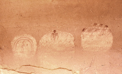
Three shields, Westwater Creek, Grand County, Utah. Photograph Peter Faris, September, 1981.

An important component of the rock art in the American Southwest represents images of shields and/or shield bearing warriors, but shields, as archeological artifacts from prehistoric times are very rare.

“Shields from across the Americas, whether of animal hide or basketry, as objects made from perishable organic materials, are inherently disadvantaged in terms of their archaeological visibility when compared with more durable lithic, ceramic, and bone products.” (Jolie 2022:3) Most shields in collections reflect the contact and historic periods where collectors have been able to acquire them for collections.

Overview of Mummy Cave coiled basketry shield showing a frog like anthropomorphic design.  Frontispiece from Culin’s (1907) “Games of the North American Indians, showing a colorized chromolithograph with an artistically rendered version of the convex surface of the basketry shield from Mummy Cave, Arizona, with froglike design. Illustration from Jolie, 2022, page 7.

In 1978 Barton Wright wrote “Prehistoric shields have been excavated from burials at Mesa Verde, Aztec, and Mummy Cave in Canyon del Muerto. All of these shields are basketry. The coil of the basket is a bundle of three willow rods laced together with yucca in a simple, non-interlocking stitch to form a circular plaque roughly three feet in diameter. The center is bowed outward slightly to leave room for the hand behind a hardwood grip. The shield is supported by this short hand grip, lashed with yucca across the inner convexity. These wooden handles were recovered intact on the Mummy Cave and Aztec specimens which is an extremely rare occurrence. The Mummy Cave shield showed that the positioning of the handle had been changed at least once, possibly for better balance.” (Wright 1976:4)

A few discoveries of shields made by basketry techniques have turned up in excavations in the American southwest. The techniques used in basketry weaving in the Southwest are plaited and coiled basketry. Plaiting is the criss-cross intertwining of the material used for things like mats. Coiled basketry uses rods sewn together with a material. “All of the shields are essentially large shallow trays or plaques made in close coiling by sewing non-interlocking stitches over a three whole rod bunched foundation. Formal variability largely exists in terms of their degree of concavity and overall diameter which, in most cases, due to the presence of a rim or coil curvature, can be estimated with a high level of certainty. Extant basketry shields range from about 50 to 88 cm in diameter.  These measurements likely give us a rough indication of the size of basketry or hide walking shields as being, on average, closer to 70+ cm. As noted above, iconographic depictions of shields are known to be up to 90 cm in diameter, but there is no reason to assume that any or all such depictions were executed to scale. Work direction is uniformly right-to-left (leftward) and work direction is always concave, resulting in the painted, decorated surface being the convex surface. In general, all of the shields reflect a technology and style wholly at home in the northern southwest during the AD 1100s and 1200s, but for which thicker foundation rods and stitching material (all likely Rhus sp.) were employed to create a thicker, denser-walled basket compared to similar contemporaneous coiled baskets of identical structure from the Southwest.” (Jolie 2022:13-14))

Center of coiled basketry shield from Aztec West Ruin, Room 95, showing adhering red pigment. Note remains of hide thong at top piercing the fabric. Photograph by Edward A. Jolie, courtesy of the American Museum of Natural History.


Artistic reconstruction of the fragmentary coiled basketry shield from Aztec Ruin West, New Mexico, Room 95, according to the two largest fragments. Illustration by Will G. Russell, based on the author’s data. Jolie, Figure 9, page 18, 2022.
Note the resemblence to the shield on the right of my opening illustration from Westwater Creek, Utah.

Gary David reported on the discovery of a basketry shield during excavations at Aztec Ruin. “In one of the rooms the bones of an obviously high-status man nicknamed “the Warrior” was found. Wrapped in a turkey-feather blanket, his skeleton measured 6’2” tall, making him at least a foot taller than the average height of males at that time. On top of his body was found a large woven-basketry shield measuring three feet in diameter. Placed on this warrior shield were several curved sticks (boomerangs).” (David:20) These were, of course, either rabbit sticks or fending sticks.

Overview of the Cliff Palace coiled basketry shield (O.574). Scale is 10 cm. Photograph by Edward A. Jolie, courtesy of the History Colorado Center. Image from Jolie, 2022, Figure 15, page 24.

“The outer surface of the Aztec shield has been painted. The central portion is blue-green with a thin rim of red. The outer margin of the shield was covered with pitch and sprinkled with powdered selenite for sparkle. The Mummy Cave shield is also decorated. The central part is covered by a frog-like figure with an orange spot on its back and the rim is painted with a divided border of yellow and blue-grey. This is the same design that occurs on the canyon wall at Betatakin. The Mesa Verde shield was badly deteriorated and no longer retained a trace of its decoration; however, it had been constructed in the same fashion as the other two examples. These shields are from the Pueblo III period of the Anasazi people dating from A.D. 1100-1300.”  (Wright 1976:4-6)

“Surprisingly, there are, in fact, a few traces of basketry shields being used in the historic period. A single extant Tohono Oodham basketry shield collected in 1884, some 49 cm in diameter, is fabricated in 3/3 twill strips of unidentified material with a burlap-like cloth covering painted black with a white floral-looking design surrounding a black center. A basketry shield is also reported for the San Juan Southern Paiute, and this is all the more noteworthy because of their residence in southern Utah/northern Arizona and the inferred influence of ancient Pueblo basketweaving traditions on their own.” (Jolie 2022:6)

Barton Wright (1976) did not believe that basketry shields would have had small efficacy once the bow and arrow were adopted. “It is extremely unlikely that these basketry shields would have deflected or stopped an arrow or lance. Since lances have never been found in archaeological context in the Southwest, they were probably not a factor in the use of a basketry shield. Native archers, on the other hand, who had little difficulty in penetrating the chain mail of the Spanish or the padded fiber armor of their mestizo warriors, would have had no difficulty in penetrating the half inch willow rods. Judd believed on the basis of his excavations that arrows, clubs and thrown rocks were the most common implements of warfare in the Southwest. It seems logical to assume that basketry shields were used for cushioning the fracturing blows of clubs or thrown rocks rather than defense against arrows.” (Wright 1976:6) As it turns out, however, basketry shields have been seen to be quite capable of stopping arrows. I suggest that Wright had forgotten that the flexibility (or “cushioning”) he writes about is an effective way of absorbing the energy of the arrow’s impact as Jolie’s discovery teaches us.

Forton disagreed with Wright, in his 2019 doctorial thesis he wrote: “Pueblo III shields were essentially coiled baskets worn on the arm and were crafted as a deterrent to the bow and arrow, which had made fending sticks obsolete. Imagery is confidently identified as depicting shields, based on physical examples excavated from Mesa Verde, Aztec Ruins, and Canyon del Muerto. The shield from Mesa Verde was too deteriorated to ascertain any designs it may have born, but the shield from the Aztec West great house was painted in concentric bands of green blue, while the Canyon del Muerto shield was painted with a froglike figure. Shields in Southwest rock art are frequently decorated with concentric circles and the Canyon del Muerto shield is similar in form to a striking shield pictograph at Betatakin.” (Forton 2019)

Closeup view of one of the two wooden projectile tips embedded in the convex surface of the White House basketry shield. Photograph by Edward A. Jolie, courtesy of the American Museum of Natural History. Jolie, 2022, Figure 12, page 21.

One basketry shield from White House in Canyon del Muerto calls into question Wright’s assertions of their ineffectiveness against the bow and arrow and confirms Forton’s statement. “Though missing its center, it is mostly complete and was at least about 74 cm in diameter originally. The convex surface exhibits a painted design in the form of a black and red checkerboard band some 20–25 cm wide that divides the basket in half. The convex surface exhibits multiple holes, some with penetrating remnants of hide thongs that suggest former pendant items and, most notably, the tips of two wooden projectiles embedded in its coils. A direct AMS radiocarbon determination on stitching fiber yielded a date of 817+/-35 rcy BP.” (Jolie 2022:17) In other words Jolie (2022) found the remains of a basketry shield with the tips of two arrows stuck in it. These are self arrows with pointed wooden tips and lacking arrowheads but, it is possible that given their smaller diameter they may have had a greater chance of penetration than a stone arrowhead.

“Sometime prior to AD 1200, coiled basketry shields may have supplanted fending sticks in response to bow and arrow use, and the newly available chronometrics on basketry shields reviewed here suggest the existence of conflict in the northern Southwest before the widely accepted social unrest of the AD 1200s. The possibility also remains that basketry shield production persisted at a low level into the historic era among some Southwestern groups. Accepting that shield imagery remains mute on construction technique, it seems prudent not to assume that all shields depicted are automatically hide.” (Jolie 2022:27) I am here suggesting that Jolie’s statement that “shield imagery remains mute on construction technique” is too negative, I believe that the many rock art images of anthropomorphs holding a spiral may be, in fact, representations of figures with basketry shields.

“Thus, visibility again looms large as a key dimension for understanding and evaluating the multiple roles of shields and shield imagery in the prehispanic Southwest. The basketry shields described above inhere with strong visual qualities that were arguably designed to impact viewersperception across multiple contexts. Although suffering from imperfect preservation that contributes to their archaeological invisibility, the very fact that three of the five known basketry shields originate from areas largely devoid of shield bearing imagery invites a renewed look at shield imagery and its distribution.” (Jolie 2022:27)

3-Kings panel, McConkey Ranch, Vernal, Utah. Photograph by Bill McGlone.

Closeup of the 3-Kings panel, McConkey Ranch, Vernal, Utah, showing three spirals representing possible basketry shields. Photograph by Peter Faris.

Closeup of the 3-Kings panel, McConkey Ranch, Vernal, Utah, showing three spirals representing possible basketry shields. Photograph by Peter Faris.

The famous 3-Kings panel at McConkey Ranch ouside of Vernal Utah shows a group of fremont figures, some of which are obviously armed warriors, with three spirals in the composition. One is in the lower right of the picture, one is next to the waist on the right side of the central figure, and the third is just above the shield being held by that central figure.

Joli wrote (2022): “Perhaps the most famous rock imagery (paintings, petroglyphs, and pictographs) shield depictions in the Southwest are those from Tsegi phase sites in the Kayenta region of southern Utah and northern Arizona dating between about AD 1250 and 1300. Numerous large-scale shields, some up to 90 cm in diameter, are executed in white, tan, purple, and pink clay mixtures and are found in or near alcoves and defensible cliff dwellings. Various interpretations of these and later shield images see them as symbolizing socioreligious or clan affiliations, community identity, or perhaps even marking the locations of particular clan or residence groups. Shield petroglyph images from Hopi have also been stated to be records of successful battles with adjacent groups (Wright 1976)." (Joli 2022:9-10) The opening line of this paragraph, of course, would only be true if the spirals associated with warriors in famous Fremont portrayals like the 3-Kings panel at McConkey Ranch, Vernal, Utah, are not meant to be examples of basketry shields.

Fremont warrior with coiled basketry shield. Glade Park, Mesa County, Colorado. Photograph Peter Faris, October 1989.

The AD 1100s and 1200s time period cited by Jolie (2022: 13-14) also falls well within the dates (AD 1 to 1301) of the Fremont Culture which resided a little farther North centered on Utah and western Colorado. (Wikipedia) Fremont basketry is a distinctive one-rod-and-bundle technique that is “so unique that it has led some to suggest that the Fremont culture can be defined on the basis of this single artifact category alone.” (Madsen 1989:9) As Wright (1976:4) stated above “All of the shields are essentially large shallow trays or plaques made in close coiling by sewing non-interlocking stitches over a three whole rod bunched foundation.” This suggests that we have no extant examples of basketry shields by Fremont peoples, however the Fremont culture area also boasts extensive shield bearing warrior imagery. Interestingly, the Fremont region also boasts many petroglyphs of warriors holding spirals, which I am suggesting may represent basketry shields. Fremont artists also left numerous images of spirals by themselves which could represent shields as well.

Fremont warrior, McKee Springs, Dinosaur National Monument, Utah. Photograph Peter Faris.

Fremont warrior, McKee Springs, Dinosaur National Monument, Utah. Photograph Peter Faris.

Basketry shields, like most baskets in the American Southwest, were created by coiling where the weft of the basket is started in the center and coils horizontally, continuously being sewn to the previously completed element inside the coil. Given this coiled construction I suggest that many shield figures holding a coil (spiral) are meant to represent figures with basketry shields, not hide shields with spiral decoration. Instead of “ceremonial objects,” or hide shields painted with spiral decoration, or figures connected to the Sun, or water, or so many of the other explanations put forward over the years, I am suggesting that many of them are warriors holding basketry shields. Sometimes things actually are what they look like they are.

NOTE: Some images in this posting were retrieved from the internet with a search for public domain photographs. If any of these images are not intended to be public domain, I apologize, and will happily provide the picture credits if the owner will contact me with them. For further information on these reports you should read the original reports at the sites listed below.

REFERENCES:

David, Gary A., Giants, Kachinas, and Cannibals, https://www.academia.edu.

Forton, Maxwell M., 2019, Shields of the Tsegi: Pueblo III Social Affiliation as Seen in Spatial Patterning of Shield Iconography, PhD thesis, Dept. of Anthropology, Binghamton University, Academia. Accessed 29 October 2023.

Jolie, Edward, 2022, Basketry Shields of the Prehispanic Southwest, The Heard Museum, June 2022, KIVA, DOI:1080/00121940.2022.2086400.

Madsen, David B., 1989, Exploring the Fremont, Utah Museum of Natural History, University of Utah, Salt Lake City.

Wikipedia, Fremont Culture, https://en.wikipedia.org/wiki/Fremont_culture. Accessed online 9 September 2023.

Wright, Barton, 1976, Pueblo Shields From the Fred Harvey Fine Arts Collection, Northland Press, Flagstaff, AZ, © The Heard Museum, Phoenix, Arizona.

Saturday, January 13, 2024

STONE CIRCLES OF SENEGAMBIA:

Stone circles of Senegal and Gambia, Africa. Online image, public domain.

There is a remarkable collection of stone circles and related monuments along the River Gambia in Gambia and Senegal in Western Africa. “The site consists of four large groups of stone circles that represent an extraordinary concentration of over 1,000 monuments in a band 100 km wide along some 350 km of the River Gambia. The four groups, Sine Ngayene, Wanar, Wasu and Kerbatch, cover 93 stone circles and numerous timuli, burial mounds, some of which have been excavated to reveal material that suggest dates between 3rd century BC and 16th century AD. Together the stone circles of laterite pillars and their associated burial mounds present a vast sacred landscape created over more than 1,500 years. It reflects a prosperous, highly organized and lasting society.” (UNESCO)

Stone circles of Senegal and Gambia, Africa. Online image, public domain.

Stone circles of Senegal and Gambia, Africa. Online image, public domain.

The comparative effort involved in the construction of these would seem to rival the creation of pyramids in Egypt or Moai on Rapa Nui (Easter Island). One can imagine whole segments of the society spending most of their time laboring on this huge complex of stone circles. “The stones forming the circles were extracted from nearby laterite quarries using iron tools and skillfully shaped into almost identical pillars, either cylindrical or polygonal, on average around 2 m in height and weighing up to 7 tons. Each circle contains between eight to fourteen standing stones having a diameter of four to six metres. The four megalithic sites inscribed bear witness to a prosperous and highly organized society with traditions of stone circle constructions, associated with burials, and persisting in certain areas over more than a millennium.” (UNESCO)

Stone circles of Sine Ngayene, Africa. Online image, public domain.

Sine Ngayene: “Sine Ngayene is the largest of the four areas, and home of 52 stone circles, one double circle, and 1,102 carved stones. It is generally accepted that the single burials found here predate the multiple burials that are associated with the construction of the stone circles. The site of Sine Ngayene is located just northwest of Sine, Senegal. In 2002, an expedition was launched in the Petit-Bao-Bolong drainage tributary; it was called Sine- Ngayene Archaeological Project (SNAP). The team found iron smelting sites and quarries located close to the monument sites. They also found evidence of hundreds of homes nearby, dating around the time of the monuments, clustered in groups of 2 – 5 with remnants of house floors and pottery shards. This evidence suggests the existence of small, linked yet independent communities. Researchers also suggest the possibility that these megalithic cemeteries could have been a focal spot of the cultural landscape and served the purpose of bringing people together.” (Wikipedia)

Stone circles of Wanar, Senegal, Africa. Online image, public domain.

Wanar: “The area of Wanar is located in the Kaffrine district of Senegal, and is made up of 21 stone circles and one double circle. – All of the monuments found at Wanar seem to mark burials, according to the archaeologists working there. Researchers have also determined that the site was a burial ground first, and the stones were added later for ritual use. Construction for this area can be narrowed down to between the seventh and fifteenth centuries A.D.

A current dating program that has begun is yielding estimates that date the construction of the double circle to between the twelfth and thirteenth centuries. A 2008 excavation was conducted on the double circle at Wanar, and two types of burials were distinguished: simple burials that consisted of large pits sealed with a mound, and more complex burials that were deep with narrow mouths. There was also a presence of perishable materials found in the burials, such as brick and plaster, that suggests the existence of funerary houses built at the time of burial.” (Wikipedia)

Stone circles of Wassu, Africa. Online image, public domain.

Stone circles of Wassu, Africa. Online image, public domain.

Wassu: “Researchers are not certain when these monuments were built, but the generally accepted range is between the third century B.C. and the sixteenth century A.D.” (Wikipedia)

Stone circles of Kerbatch, Gambis, Africa. Online image, public domain.

Kerbatch: “Kerbatch, an area comprising nine stone circles and one double circle, is located in Gambia’s Nianija district. Kerbatch features a V-shaped, ‘bifid’ stone (the only one in the region) that had broken in three places and fallen. This stone, that had been part of a frontal line, was restored during the 1965 Anglo-Gambian Stone Circles Expedition led by P. Ozanne. During thes expedition Ozanne and his team excavated the double circle at Kerbatch.” (Wikipedia) These are listed as the major concentrations although there are a number of other monuments and stone circles.

“During the medieval period of Europe which corresponds roughly to the Golden Age of West Africa, several great empires and kingdoms sprang out from the Senegambia region, including but not limited to the great Ghana Empire, the Mali Empire, the Songhai Empire, the Jolof Empire, the Kaabu Empire, the Kingdoms of Sine, Saloum, Baol, Waalo and Takrur. During this period several great dynasties rose and fell, and some, such as the Guelowar Dayasty of Sine and Saloum, survived for more than 600 years despite European colonialism, which fell as recently as 1969, nine years after Senegal gained its independence from France.” (Wikipedia) In the eurocentric world view that we have inherited we tend to forget that other cultures reached surprising heights long before our culture developed. Not only the scale and magnitude of these monuments attests to the cultural height of these kingdoms, but also their other arts and cultural advancements.

“The integrity of the four components of the site can only be evaluated as part of a much wider unified cultural complex. The complexes conserve their integrity in terms of spatial associations of the component circles, individual megaliths and tumuli. The spiritual beliefs associated to the stones by local communities help protect their integrity. The stone circles stand in a farmed landscape and there have been few interventions. A very small number of stones have been removed. Some burial sites have been excavated and subsequently back-filled. These disturbances remain minimal. The oval authenticity of the four sites is intact.” (UNESCO) It seems a little awkward to me to refer to “100 km wide along some 350 km” in length as a site – singular – but later the plural sites is used.

These stone circles represent a notable cultural accomplishment, attesting to a high level of civilization whose greatness deserves to be preserved and remembered.

NOTE: Some images in this posting were retrieved from the internet with a search for public domain photographs. If any of these images are not intended to be public domain, I apologize, and will happily provide the picture credits if the owner will contact me with them. For further information on these reports you should read the original reports at the sites listed below.

REFERENCES:

UNESCO, Stone Circles of Senegambia, https://whc.unesco.org/en/list/1226. Accessed on 12 February 2023.

Wikipedia, Senegambian stone circles, https://en.wikipedia.org/wiki/Senegambian_stone_circles. Accessed on 12 February 2023.

Wikipedia, Senegambia, https://en.wikipedia.org/wiki/Senegambia#Media. Accessed on 17 February 2023.

Saturday, January 6, 2024

ROCK ART IMAGES OF EARLY ROCK CLIMBING AND ROPES:


 Closeup, A honey hunter climbing a rope ladder at abrigo de Barranco Gómez in Castellote, Teruel, Spain. Online image public domain.

Back in February 2022 I did a column on some pictographs of honey gathering from Spain. In that one I focused on the idea of the importance of honey to the societies and the lengths they would go to gather it. Recent studies have taken another track, to the implications of the climbing itself and the ropes and other equipment required in acquiring the honey.

As seen on cliff face at abrigo de Barranco Gómez in Castellote, Teruel, Spain. Image from Bea, 2013.

Drawing and hypothical sections of rope ladder based on the pictograph. Online image, public domain.

“Direct or indirect evidence of ropemaking are scarce in European prehistory. Only a few references to Middle or Upper Palaeolithic remains are known to us, with more examples towards the Holocene. The archaeological contexts of ropes offer little information about possible uses, as the activities they are used for are often archaeologically invisible. However, some rock-art traditions shed some light on potential uses, worth exploring. In Spain, Levantine rock art offers the best graphic examples across Europe showing various uses of ropes, including climbing. Starting from the recently discovered climbing scene of Barranco Gómez site (Teruel, Spain), including the best preserved and more complex use of ropes seen so far in Levantine art. - Different rope-making techniques were used by Levantine societies, which we believe are indicative of a complex rope-making technology, requiring a considerable investment of time and efforts. It also shows a certain variety of rope climbing techniques and rope climbing gear, illustrating that both were mastered by Levantine societies. Moreover, a preferential use of ropes in honey-hunting scenes is observed.” (Bea et al. 2023)


Fragment of rope in situ, Lascaux Cave, France. Image from donsmaps.com.

Fragment of rope, Lascaux Cave, France. Image from donsmaps.com.


There have been a few samples of rope recovered from ancient sites in Europe. These pictures from Don Hitchcock at www.donsmaps.com show an excavated sample of rope, as well as an imprint in dried mud of a rope that has disappeared with age.

Rigid climbing systems (tree trunks, masts or branches). (1 & 2) Los Trepadores (after Beltrán Reference Beltrán2005); (3) La Higuera (after Baldello). Image from Bea, 2013.


“The catalogue of Levantine Rock Aat includes hundreds of sites, but explicit representations of ropes or rope-ladders are rare. Some of the known examples cannot be linked to a specific activity, but most of them are related to climbing. Nevertheless, climbers do not only use ropes and rope ladders, but occasionally climb some type of plants, branches or trees. Climbers are either related to wild boar hunting, honey hunting or unidentifiable activities, as they are isolated or are part of incomplete scenes.” (Bea et al. 2023)

“Within the foothills of the Iberian System Mountain Range in northeastern Spain, archaeologists have discovered a 7,500-year-old painting depicting prehistoric humans gathering honey. The exceptionally detailed image shows a figure climbing a rope ladder to reach a colony of bees.” (Saed 2021) While we have the pictures of figures climbing ropes up cliffs we have no indication of their equivalents of modern climbing equipment. I suppose we can project a few things like a wooden peg pounded into a crack in the rock with a hammerstone, instead of a metal piton, and a loop tied into the rope instead of a carabiner.

  Flexible climbing systems. Stirrup ladders: (1) Barranco Gómez; (2) Cingle de l'Ermità.      Ropes: (3) La Araña (Hernández-Pacheco;          (4) Los Trepadores (after Beltrán).                             Images from Bea, 2013. 

“Manuel Bea, a researcher from the University of Zaragoza, authenticated the painting alongside colleagues Ines Domingo and Jorge Angas. ‘We have a perfect photograph,’ he explains, that provides insight into just how these practices were conducted: by climbing ropes. The Barranco Gomez rock shelter was found by a nearby resident in 2013, but the analysis of the painting published just this year.” (Saed 2021)  The Barranco Gomez pictograph clearly shows some sort of rope ladder with a pair of ropes connected somehow creating openings for the feet. The authors of the paper (Bea et al. 2023) postulate that the second rope is repeatedly tied around the first, spaced comfortably apart to create a series of loops for the foot. This suggestion seems to fit comfortably with what can be seen in the image. What cannot be seen, however, is how it is fastened at the top of the rope, what secures it to the cliff?

The team was able to get quite a bit of information out of their analysis. “The unique honey-hunting scene from Barranco Gómez site illustrates the use of a truly complex rope-making technology. Close observation of this depiction does not assist in identification of the rope-making techniques (whether twisted or plaited fibres), but the use in climbing and the length show that Levantine societies were technologically advanced in the production of quality ropes. We estimate that each loop of the ladder (considering a minimum of 25 cm high and 20 cm wide) requires up to 80–85 cm of rope (including the necessary knots), so the rope length was possibly 25 m after the 29 stirrups depicted in the scene. Given that, the ladder itself could have been up to 7.5 m in length. The proportions of the length of the ladder and the height of the climber (assuming a height of 1.7 m) would fit perfectly.” (Bea et al. 2023)

Climbing illustrated in Cueva de las Aranas. Image from Bea, 2013.

Drawing of climbing illustrated in Cueva de las Aranas. Image from Bea, 2013.

The image from Cueva del las Aranas appears to show three vertical ropes with no horizontal rungs or loops of any kind. This may be meant to show an instance of shimmying up the rope, but again no details on its connection at the top other than some angled lines that the ropes connect with. These angled lines at the top have been suggested to represent branches.

“What is important is that Levantine groups had a refined technique for rope making, which was adapted to produce long ropes for climbing activities. When the action represented in the scenes displaying rope equipment can be deduced, honey hunting is the only well-defined activity. While this activity was depicted in different parts of the Levantine territory in the final stages of the sequence, it is completely absent in the initial stages, marking a significant change in the cultural treatment this activity had over time.” (Bea et al. 2023)

The authors of this study (Bea et al. 2023) have also included images of a number of other climbing scenes from rock art in the Levant including not only more that appear to be climbing ropes, but also apparently using trees or limbs for vertical access. This is an interesting and informative look at a vestige of early technology that we seldom think of, and I highly recommend it for fascinating reading.


NOTE: Some images in this posting were retrieved from the internet with a search for public domain photographs. If any of these images are not intended to be public domain, I apologize, and will happily provide the picture credits if the owner will contact me with them. For further information on these reports you should read the original reports at the sites listed below.

REFERENCES:

Bea, Manuel, Didac Roman, and Ines Domongo, 2023, Hanging over the Void. Use of Long Ropes and Climbing Rope Ladders in Prehistory as Illustrated in Levantine Rock Art, 8 June 2023, Cambridge University Press (online). Accessed online 19 July 2023.

Faris, Peter, 2022, Some Sweet Pictographs – Honey Collecting in Spanish Rock Art, 12 February 2022, https://rockartblog.blogspot.com/search/label/honey%20gathering

Hitchcock, Don, A rope from Lascaux Cave, https://donsmaps.com/lasc auxrope.html. Accessed online 25 July 2023.

Saed, Omnia, 2021, Found: A 7,500-Year-Old Cave Painting of Humans Gathering Honey, 16 December 2021, Atlas Obscura, https://atlasobscura.com/articles/honey-cave-painting

Wikipedia, Rope, https://en.wikipedia.org/wiki/Rope. Accessed online 25 July 2023.