Wednesday, December 29, 2010

THE NU’UANU PETROGLYPHS, OAHU:

On October 23, 2010, we were given a tour of the Honolulu area by my cousin Rob and one of the sites that we located was the Nu’uanu petroglyphs. They are located in Nu’uanu valley which is where the deciding battle of King Kamehaha I’s drive to conquer Oahu and thus unify the Hawaiian islands occurred in 1795.
Nu'uannu Stream, Honolulu, Oahu, Hawaii. Photo: Peter Faris, Oct. 23, 2010.
According to Wikipedia the battle “is known in the Hawaiian language as Kalelekaʻanae, which means "the leaping mullet", and refers to a number of Oahu warriors driven off the cliff in the final phase of the battle. Kamehameha I had begun his campaign to unify Hawaii in 1783, but prior to 1795 had only managed to unify the Big Island. In February 1795 he assembled the largest army the Hawaiian Islands had ever seen, with about 12,000 men and 1,200 war canoes. Kamehameha initially moved against the southern islands of Maui and Molokai, conquering them in the early spring. Then he invaded Oahu”. (http://en.wikipedia.org/wiki/Battle_of_Nu'uanu)

Nu'uannu petroglyphs, dogs and human figures. Honolulu,
Oahu, Hawaii. Photo: Peter Faris, Oct. 23, 1020.

Kamehameha I prevailed and at the climax of the battle, caught between the Hawaiian Army and a 1000-foot drop, “over 400 Oahu warriors either jumped or were pushed over the edge of the Pali” (http://en.wikipedia.org/wiki/Battle_of_Nu'uanu) - the leaping mullet. This had been the last major challenge to Kamehaha I and afterword the combined islands were known as the Kingdom of Hawaii.

Dog petroglyphs, Nu'uannu, Honolulu, Oahu, Hawaii.

The Nu’uanu petroglyphs consist of three sites along the Nu’uanu stream behind the Nu’uanu Memorial Park Cemetery and the Royal Mausoleum, near Alapena pool. They have a total of as many as forty carved images mostly human figures and dogs. The number of dog images is somewhat surprising as there are no wild canids on the Hawaiian Islands to commemorate, so they have to be representations of the domestic dog (Canis lupus familiaris).

While the meaning of these dog images is not known for sure there are a number of possibilities in mythology listed in Traditions of O’ahu: Dog Gods of the Ko'olau Mountains. A number of the tales involve a supernatural dog named Poki. Seeing Poki was an ill omen and a traveler who saw the dog would be wise to return home to avoid disaster. In other tales Poki was the pet of an evil spirit living in the mountains.

Nu'uannu petroglyphs, dogs and human figures. Honolulu,
Oahu, Hawaii. Photo: Peter Faris, Oct. 23, 1020.

There is another interesting myth involving a dog. In this myth Kane, the chief god of the Hawaiian pantheon used to party with his companions at night in the mountains over Wai-pi’o valley and each drink of awa (the intoxicating drink known as kava in the Pacific islands ) was accompanied by a blast on their conch shell horns (pu). Kane’s horn, the famed kiha-pu, was of divine origin and possessed supernatural power, as well as being louder than any other. These loud sessions disrupted the whole countryside and kept the inhabitants awake all night. To deal with these disruptions King Liloa sent a dog named Puapualenalena to steal Kiha-pu, which subsequently became a prized possession of Hawaiian monarchs. (http://www.sacred-texts.com/pac/ulh/ulh22.htm) This Kiha-pu can be seen on display at the Bishop Museum in Honolulu.
One myth directly related to the Nu’uannu petroglyphs claims that they portray a mythical dog named Kaupe who had once been a human who had ruled Nu’uanu valley. During his reign he ate a lot of people and later Kaupe became a malevolent spirit in dog form that calls out to people at night to lure them to their deaths. (Reference: http://en.wikipedia.org/wiki/Kaupe)
Whichever story we choose to believe this concentration of dog petroglyphs seems totally unique and is off the beaten path so it may not be visited as regularly as more publicized sites.

References:

Traditions of O’ahu: Dog Gods of the Ko'olau Mountains, Asia-Pacific Digital Library, Kapi’olani Community College, (http://apdl.kcc.hawaii.edu/~oahu/stories/kona/doggods.htm).

Wikipedia


Wednesday, December 22, 2010

A PAINTED BOULDER IN SOUTHPARK, COLORADO:

Hereford, West face of the painted boulder, South
Park, Colorado. Photo: Peter Faris, 1994.

One day in the summer of 1994 I was driving down South Park in the Colorado Rockies on C-285 headed for Chaco Canyon when I came upon this idyllic scene. I do not know exactly what caused me to pay attention to this cow specifically because there is no shortage of cattle in pastures along rural roads in Colorado to observe. Something about this cow lying down in the field attracted my attention. A few seconds later I looked back in the rear-view mirror and saw the second scene. I pulled over and stopped on the shoulder of the highway before turning around and going back to take the pictures included here.

This erratic boulder in the field which so resembles in size and shape the form of a reclining cow had been (as you can see) painted to look like just that, and cleverly, whoever the artist had been, a different breed was used for each side. The east face of the boulder resembled (to my eyes anyway) a Holstein while the west face of the boulder was obviously a Hereford. They were certainly well enough done that they stood up to a casual glance and I was at least momentarily fooled by the scene.

Holstein, East face of painted boulder, South
Park, Colorado. Photo: Peter Faris, 1994.

To me this is a wonderful example of playfulness, whoever painted this boulder (and I assume that it was the rancher who owns the land it lies on) took the time and effort with no possible profit other than the joy involved. And it has been kept up as far as I know. The last time I saw it was just a couple of years ago and it was still painted although the paint looked much less fresh than when I first saw it. In its current incarnation it is not painted as two different breeds, at my last observation of it both sides were painted to look like the Hereford.

Each time I drive down C-285 I look forward to visiting my old friend, and it has been that way for the past sixteen years. My thanks to that anonymous rancher for adding a spot of joy to the world. Oh, and by the way, good job painting too!

A REVIEW - READING THE ROCKS:

A REVIEW: Reading the Rocks: Aboriginal Australia’s Painted History, by Samir S. Patel, pages 32 – 37 & 68, Archaeology, January-February 2011, Vol. 64, No. 1.
This article, excellently written by Samil S. Patel, a senior editor and writer at Archaeology, is about the researches of archaeologist and rock art specialist Paul S. C. Tacon of Griffith University in Gold Coast, Australia, at the amazing rock art site of Djulirri in the Wellington Range of Arnhem Land in northern Australia. Its setting is a visit with Tacon and the aboriginal owner of the site Ronald Lamilami to Djulirri which affords the opportunity to describe the site and its significance. Djulirri’s additions and overpaintings cover an immense period of time. Tacon traces its early images back 15,000 years and the last major additions to the panels were painted about 50 years ago.

Aside from good information, and a very interesting look at the Australian rock art tradition, the importance of this piece by author Samir S. Patel is that for a change rock art is being discussed as a valid part of the historical record and a source of cultural information. “Djulirri is among the top handful of rock art sites in the world, and in its layers of pigments and stained rock is an abundance of information about Aboriginal culture and how it dealt with the sweeping changes of the last few centuries.”

This article also includes valuable information on how the aboriginal culture understands the rock art record. “All the stories are here in the rock” says Lamilami. “Each year, a new concept would be drawn - what happened the year before that, it’s a time lapse.” Patel points out that “Other rock art sites, such as Lascaux in France, capture only a narrow period of time, and even the deepest archaeological deposits aren’t willful creations like this. Djulirri might be the longest continuously updated human record in the world.” In other words according to Lamilami, this site represents an annually updated record of what happened to his people over that span of time, much like the winter counts of many of the Native American tribes of the Great Plains of North America.

I feel that this six page article contains more real understanding and usable information than some of the books on rock art sitting on my bookshelf. Do yourself a favor; make sure you get to read this one.

Wednesday, December 15, 2010

BIRDS IN ROCK ART - MACAWS:

Among the birds pictured in rock art of the American southwest are the figures of some birds that are not native to North America but which had been imported from Meso-America. These alien visitors are parrots and macaws. Macaws and parrots, along with copper bells, and sea shells were imported from the jungles of southern Mexico, up to 1,000 kilometers (more than 600 miles) to the south.
Macaws and parrots were important birds in prehistoric Mimbres-area communities by A.D. 1000. Scarlet macaws apparently were imported into the area from the tropical lowlands in Mexico. Macaws in particular evidently were of special, perhaps ceremonial, importance as indicated by consistent age at death, probably reflecting sacrifice in the spring, and by deliberate burial, often in special rooms in the community. Remains of macaws and parrots were also found in abundance at Chaco Canyon and other sites proving that not just the feathers, but the birds themselves had been traded for.

There were basically two species of Macaw that were prehistorically imported into the American southwest from Mesoamerica. These are the military macaw (Ara militaris), a green feathered species, and the scarlet macaw (aro macao). The military macaw is from relatively dry areas and its range reached to within 20-30 miles of the Arizona/Mexico border. The scarlet macaw occupied wetter habitation so its natural range ends considerably farther south (Hutchins 36-37). Scarlet macaws are relatively easily tamed and so would have been easier to transport (Hutchins p.40).

Three macaws, Hovenweep National Monument,
Utah/Colorado. Photo: Peter Faris.

My petroglyph of macaws is located at Hovenweep. There are three of the birds arrayed horizontally across the center of the picture with their heads with curved beaks facing to the right and their tails pointing out to the left. The bird on the right has a squared fret design sticking up from its tail, the center bird seems to be standing on a Mesa Verde style t-shaped doorway, and a smaller, fainter one is on the left side past the spiral.

Close-up of three macaws, Hovenweep National
Monument, Utah/Colorado. Photo: Peter Faris.

Native American societies prized feathers for decorative purposes as well as for their perceived symbolic and spiritual meanings. For any people who highly prized feathers the feathers of Mexican macaws would have been valued highly indeed for the beauty of their bright colors. Pueblo peoples associated macaws with the rainbow because of their bright colors and, as birds, they belonged in the sky. The accompanying complex of associations included clouds, the sun, and rain, and maize (which needed rain to grow). The multicolored plumage of macaws also suggested the many colors of kernels found on Indian maize. Thus it is not surprising that macaw and parrot feathers were important for the creation of “Corn Mother” fetishes. Pueblo peoples create “Corn Mother” fetishes, based on a perfect head of corn bundled within a cluster of feathers. Called the mi’li at Zuni, the base was hollowed out and a heart of flint was placed within. Called a tiponi at Hopi, instead of flint it held seeds. Among the feathers affixed to the corn mother, the feathers of the macaw were highly prized. They would have also been prized for the creation of Pahos the so-called "prayer sticks".

Parrot effigy pot, Tonto polychrome, ca. 1300-1400,
p.189, Brasser, Native American Clothing, 2009

The Tonto polychrome macaw effigy pot illustrated was created by the Hohokam people of southern Arizona.

It is hardly surprising then to find images of parrots and/or macaws in the rock art of the region. While we cannot know if the motive for the creation of their images was to invoke spiritual influences, a prayer for rain, or just to brag about wealth, it is interesting to reflect that the images of parrots and macaws are placed on the rocks in a region where they never naturally lived. These images remain as a symbol of the complexities of the culture of these people who benefited from these long distance trade networks.

Reference:

Hutchins, Megan
2008   Survey of the Macaw, p. 36-44, in Mesoamerican Influences in the Southwest, Kachinas, Macaws, and Feathered Serpents, edited by Glenna Nielsen-Grimm, Museum of Peoples and Cultures, Popular Series #4, Brigham Young University, Provo, UT.

Wednesday, December 8, 2010

PACHYDERMAGLYPHS - NOT REALLY ROCK ART:

In March 2004, we had an opportunity to visit the fascinating rock art of Hueco Tanks, east of El Paso, Texas. While the main purpose of the visit was to see the numerous mask pictographs at that location we saw many other things as well. Named for a number of natural pools of rainwater (or tanks) so valuable to non-technological people in that arid landscape, Hueco Tanks has obviously attracted visitors for millennia. According to the DesertUSA website: “Over the millennia, Hueco Tanks has drawn desert plant and wildlife communities and prehistoric and historic man into its folds primarily because its huecos (a Spanish word for “hollow”) – especially the deep ones that lie beneath sheltering rock ceilings – trap and hold drinkable water, that most valuable desert commodity. Indeed, as Robert Miles and Ron Ralph said in an article in The Handbook of Texas Online, Hueco Tanks held virtually the only dependable source of water between the Pecos River, roughly 120 miles to the east, and El Paso, some 30 miles to the west.”


Mammoth rub, Hueco Tanks, Texas.
Photo: Peter Faris, March 2004.

Not too far from the park headquarters, our ranger guide pointed out an area up on the cliff face where the rock projection had been been artificially smoothed and polished. This smoothing had been done by mammoths scratching their itches by rubbing against the rock. According to the ranger this had been confirmed by laboratory analysis which found the remnants of proteins from their skin and hair absorbed into the rock.

A number of other such locations have been discovered and can be researched online. This vestige of Paleolithic giants gave one a sense of personal connection. Unlike the sterility of simply academic knowledge of their former existence, here we could personally experience contact with a rock that they had rubbed up against. This feeling was not at all unlike the feeling we get when in the presence of rock art, that we can somehow contact on a personal level the reality of the person who created the art, and what can be more exciting than that?

Although these are generically known as "mammoth rubbing stones" and that is certainly accurate and descriptive, I have been looking for a technical term to apply to these sites. In the context of RockArtBlog I have decided to name them pachydermaglyphs - what do you think?

Reference:
http://www.desertusa.com/mag07/april07/Hueco.html

Wednesday, December 1, 2010

POHAKU KA LUAHINE, MOANALUA VALLEY, OAHU:

Pohaku Ka Luahine, Moanalua Valley, Oahu. Showing one deeply
pecked anthropomorph and some random markings and grooves
on the top. Photo: Peter Faris, October 23, 2010.

Pohaku Ka Luahine is said to translate as "the rock of the old woman". It was reportedly given this name after an incident in which a child broke kapu by crying at a religious ceremony, an offense punishable by death. The child’s grandmother ran up the valley with it and hid behind the stone until the kapu expired and the warriors stopped searching for them.
 
Pohaku Ka Luahine, Moanalua Valley, Oahu. Showing 
random markings and grooves on the top.
Photo: Peter Faris, October 23, 2010.


Pohaku Ka Luahine, Moanalua Valley, Oahu. Showing two faintly
pecked anthropomorphs and the trunk of the mango tree it sits under.
Photo: Peter Faris, October 23, 2010.

Wikipedia gives a short history of the Moanalua valley. “Samuel Mills Damon inherited the ahupuaʻa (uplands-to-sea tract) of Moanalua in 1884 from Princess Bernice Pauahi Bishop, whose husband Charles Reed Bishop was a business partner of Damon. Before her, since the lands were won in battle by Kamehameha I they passed from Kameʻeiamoku to Ulumāheihei Hoapili, then to Prince Lot Lot Kapuāiwa (who became King Kamehameha V), and Princess Ruth Keʻelikōlani. Damon later became one of the first trustees of the Kamehameha Schools established by the Bishops. The Damon estate sold much of Moanalua to commercial and residential developers in 1956.” Formerly part of Samuel Mills Damon estate, the trail follows the old estate carriage road up the valley from the Moanalua Valley park.


Old carriage road hiking trail, Moanalua Valley, Oahu.
Photo: Peter Faris, October 23, 2010.


Cobbles of the old carriage road hiking trail, Moanalua
Valley, Oahu. Photo: Peter Faris, October 23, 2010.

With cousin Rob as my guide we hiked up the cobbles of the old carriage road the requisite seven crossings of the stream and there on the right under the mango tree just as described was the petroglyph boulder Pohaku Ka Luahine. Earlier records credit this boulder with twenty one anthropomorphic figures as well as a 90-point konane game board (James 2010:49). Unfortunately it has received a certain amount of vandalism and appears to have suffered from weathering erosion as well. A few traditional style Hawaiian figures are visible on the sides of the stone. I could not really see the grid of pits of the konane game board supposedly pecked into the top. This is a checkers-like game played with black and white pebbles by Hawaiians and examples have been found with one hundred and more pits pecked into boulders. Given the dim light under the jungle canopy there were few options for visual clues from side-lighting, the surface of the boulder appears fairly uniform, and much of what can be seen did not come through on photos.


It was certainly a lovely hike through the jungle though, well worth it for the exercise alone, and to also see the rock art made it a really special afternoon.

Reference:

James, Van
2010      Ancient Sites of Oahu: Revised Edition, Bishop Museum Press, Honolulu.

Friday, November 26, 2010

A POLL ON THE EFFECTIVENESS OF SECRECY IN PROTECTING ROCK ART SITES:

For a few weeks until July 24, 2010, the poll question on RockArtBlog was Do You Believe That Secrecy Protects Rock Art Sites, Or Is The Broadest Transparency And Education Possible More Effective? The answer choices are listed below along with their votes.

Open and effective education and site stewardship provide the best protection. 4 votes, 44.44%

Plant poison ivy and fertilize regularly. 3 votes, 33.33%

Controlled access limited to acknowledged researchers and scholars. 1 vote, 11.11%

Keep it totally secret - do not let anyone (including vandals) know where it is. 1 vote, 11.11%

It is important to remember the disclaimer, that this is only an opinion poll and in no way represents objective proof. It is also not possible to confirm the qualifications of the respondents. That said, it does represent the actual responses to an actual question and is worthy of note. We do not seem to believe that secrecy works to protect rock art.

Saturday, November 20, 2010

HALLEY’S COMET PICTURED IN CHACO CANYON:


Archaeoastronomy panel, Peñasco Blanco Trail,
Chaco Canyon, NM. Photo: Peter Faris, 1997.

Archaeoastronomy is the study of the astronomical knowledge of ancient peoples. Students of archaeoastonomy have long been fascinated with the evidence for ancient astronomy found in Chaco Canyon consisting of the Fajada Butte sun calendar and the supposed supernova panel on Peñasco Blanco trail. High above Chaco Canyon’s Peñasco Blanco trail can be found a panel that has often been identified as the Supernova of AD 1054 that produced the Crab Nebula. This well known panel includes a crescent moon, a 10-pointed star which is believed to represent the supernova explosion, and a hand print.


Archaeoastronomy panel, Peñasco Blanco trail, Chaco
Canyon, NM. Red color enhanced to bring out the tail of
the comet pictograph below. Photo: Peter Faris, 1997.

What is not usually mentioned is that there is more rock art at that location. Right below the supposed supernova panel on the rock overhang, and painted in white on the face of the cliff is a large concentric circle symbol, often identified as an Ancestral Pueblo sun symbol. In this case, however, what appears to be a faded flame-like extension can be seen projecting to the right from the sun symbol. This extension, which also appears to be considerably obscured by dust, seems to combine with the sun symbol to represent a comet. Using the large sun symbol as the head of the comet certainly implies that it was large and bright.

Chaco Canyon was a major center of Ancestral Puebloan culture between AD 900 and AD 1150. During that period Halley’s Comet appeared in AD 912, AD 989, AD 1066, and AD 1145. Elsewhere in the world the AD 1066 appearance figured as an omen in the Norman conquest of England and, as such was also portrayed in the Bayeux Tapestry record of Duke William’s conquest. One old written reference in England mentions it as appearing four times as bright as Venus, and another likened its size and brightness to that of the moon.


Field sketch of Halley's comet pictograph,
Peñasco Blanco trail, Chaco Canyon, NM.
Peter Faris, 1997.

I submit that the brightest and most impressive of these appearances would be the obvious candidate for reproduction above the Peñasco Blanco trail. From the information available that was probably the AD 1066 appearance of Halley’s. The proximity of that date to that of the supernova of AD 1054 also is suggestive of the AD 1066 appearance as we know that someone in that location had painted an astronomical event probably twelve years earlier. Certainly the people there at that time showed interest in the events seen in the heavens as is proved by the Fajada Butte Sun Calendar and the supernova panel. These clues suggest to me that the faded pictograph below the supernova panel is a record of the AD 1066 appearance of Halley’s Comet.

Tuesday, November 16, 2010

New Technique in Digital Photography may have Important Applications in the Study of Rock Art and other Scientific Applications:

My friend Teresa forwarded this information: from Southwest Archaeology Today, news from the Center for Desert Archaeology, in Tucson, AZ.
A technique called GigaPan can be used to take incredibly detailed photographs of rock art. Rock art expert Sandra Olsen and photographer Richard T. Bryant took this technology to Saudi Arabia to document its rock art, working with the Saudi Ministry of Education. You can view some of their results and see the marvelous detail the technique achieves online at
http://news.nationalgeographic.com/news/2010/11/101112-gigapan-science-panoramas-technology/

Thursday, November 11, 2010

WIZARD STONES, WAIKIKI BEACH, OAHU:

In October 2010, we vacationed in Waikiki, Oahu, Hawaii, and took the occasion to visit some rock art sites on the island, and also found the Waikiki Beach Wizard Stones.

Waikiki beach "Wizard Stones", view looking west,
Oahu, Hawaii. Photo: Peter Faris, 10/27/10.
 
“These ancient stones, according to tradition, were once empowered with the mana (spiritual power) of four great kahuna (wizards) who arrived from Kahiki (the traditional homeland; some say Tahiti or the Society Islands) before the reign of the 16th century ruler of Oahu, chief Kakuhihewa. These kahuna, who became widely known throughout the islands as healers, instructed the people that four large stones should be moved from nearby Kaimuki and placed on the beach at Waikiki.” (James 2010:27) Kaimuki is a small crater on the North side of nearby Diamond Head.

The particular stones chosen supposedly consist of “bell stone” a special basaltic rock from Kaimuki quarry, that produces a bell-like ringing tone when struck. Although they were originally in separate locations, over the years they have been consolidated and in 1980 were moved into their present location in Kuhio beach park, which originally held only one of the four.

Waikiki beach "Wizard Stones", view looking northeast,
Oahu, Hawaii. Photo: Peter Faris, 10/27/10.

While they display no actual imagery or show no signs of carving, I include them because of the special spiritual significance that are afforded these stones by native Hawaiian peoples. In the late 1800s, Princess Likelike, sister of King Kalakaua, placed a lei on each stone as an offering and prayed before going into the water. (James 2010:27-28) Today offerings are often found placed upon the stones as well (note leis hanging from the fence in photo no. 2), a phenomenon we recognize in North American at many rock art sites as well as other sites of spiritual significance.

Wednesday, November 3, 2010

COWBOY ROCK ART - CONTINUED:

On Tuesday, July 6, 2010, I published a posting about cowboy rock art in Trinchera Pass, Colorado. This collection of rock art was supposedly created by drovers moving herds from Texas to the gold fields of Colorado in the latter half of the 1800s. It displays many markings and symbols as well as some pictures that are almost light-hearted and humorous. There is another side to cowboy rock art, the imagery produced by men who spend a considerable amount of time alone, in isolation, and lonely. These are often female figures of the sort that we generally classify as pinups, attractive and physically appealing. There is an inescapable comparison to be made with the historic aircraft nose art of WWII, also produced by men who were in a situation that minimized contact with females, and also often included images of nude or scantily clad females.

Baca County, Colorado. Photo: Bill McGlone.

An excellent example of this type of art is the panel from Baca County, CO. Its identification as cowboy art is reinforced by the presence of the small figure of a rider on a rearing horse on the right side of the panel.

Dragon trail, South of Rangley, Rio Blanco county, Colorado.
Photo: Peter Faris.

In this case I am extending the term “cowboy art” to include that produced by sheep herders, who were in very much the same situation toward female companionship. An example of this is the delicate caped lady carved in Canyon Pintado by Paco Chacon of Fruita, Colorado, on January 9, 1975. Unfortunately since I saw it some twenty plus years ago some idiot apparently saw only sin and decadence and decided to exorcise the evil with some thirty plus gunshots as illustrated by the second photo which was taken by Cheryl Ames in 2008.

Dragon trail, South of Rangley, Rio Blanco
county, Colorado. Photo: Cheryl Ames.


Thursday, October 28, 2010

AN EXCITING ANALYTICAL TECHNIQUE - X-RAY FLUORESCENSE SPECTROSCOPY:

Back in the early 1980s, I first heard of a very exciting analytical technique being applied to art history studies – neutron activation analysis. This was described in an article by Maurice J. Cotter, Neutron Activation Analysis of Paintings published in the January-February 1981 issue of American Scientist magazine (pages 17-27). It is based upon the same general phenomenon as C14 dating, that each element has its own discrete atomic half life. If you can use some form of radiation source to irradiate a sample and induce radiation in it, the rate with which that radiation dissipates (its half life) can be measured and analyzed to identify the discrete elements in the sample and their respective proportions. Of course, that reading would be of the remaining elements of the paint as well as the elements in the surface that the paint is on. By taking readings of an adjacent area of unpainted stone surface, a comparison would then illuminate the contents of the paint. Simply put, any difference in the readings between the two areas can be assumed to represent the contents of the paint. At the time I recognized that having portable equipment to do this would allow us to begin to identify the pigments used in the paint of pictographs, but alas, I am not a nuclear scientist.


Multiple colors, Notches Dome, WY,
Photo-Bonnie Newman, 2005

A technique similar to this has now been applied pigment analysis of rock art in just that manner in a fascinating project conducted by Bonita Newman and Dr. Lawrence Loendorf. They used portable x-ray equipment in July 2005 to analyze the elements in the pigments of pictographs at rock art sites. Newman described the process as follows:
Dr. Loendorf  taking a reading, Photo - Bonnie Newman, 2005

“Pigment analysis at the three selected sites was conducted with a portable x-ray fluorescence spectrometer. This small, light hand held unit provides non-destructive elemental analysis.

As the atoms of an element are struck by high energy photons from the x-ray source, electrons from the inner shells are knocked from their orbits around the nuclei of the atoms, causing those atoms to become unstable ions. To re-establish stability, electrons from the next higher shell move to the vacant inner orbits emitting energy as they move.

This phenomenon is referred to as fluorescence. Since each element maintains a different electron shell configuration, the spectrum produced by each episode of fluorescence is unique, allowing the element to be identified.”

Now think about how important this actually is. After a century of guessing and making assumptions about the chemical contents of the paint used in producing pictographs we can now know exactly what those elements are! Think of what a database this will eventually be.

In a future posting I will discuss some of the results of their studies.
ACKNOWLEDGEMENTS:
Bonita Newman is an archaeologist with ICI Corporation, Virginia Beach, VA., and is currently a member of the board of directors of the Colorado Rock Art Association. Lawrence Loendorf is a noted rock art researcher, a former president of the American Rock Art Research Association, and is a retired New Mexico State University professor.

Tuesday, October 19, 2010

IS ROCK ART REALLY ART?

One of the questions that beginners in rock art studies often get passionately involved in is “is rock art really art?” Indeed, it often seems that the less the person actually knows, the more passionately they adopt and argue their positions on certain questions, and this question of “is it art?” seems to generate more steam than most. We hear endless facile (and ultimately meaningless) statements about people (the creators of the rock art) who do not even have a word for the concept of art and who strive to do everything well (italics mine), etc.

The truth is, of course, that it has never been left up to the creators of material to designate its status as art. Indeed, it makes no difference what their intentions were when producing the images. Historically materials have received the designation of “Art” if they proved of interest to collectors, and once notice had been taken of these materials they were quickly incorporated into the field of studies designated as Art History.

Indeed, except for a short period of time during the renaissance it really wasn’t until a little over a century ago that the creators of works designated as art were consulted much at all about what they did. The producers of “Modern Art” argued loud and long for the artistic legitimacy of what they produced. The truth is as it always has been that the designation of what is or is not art has never depended upon the intentions of the creator. It has always come from the collectors who were fascinated by the material, and the scholars who subsequently studied and classified it.

So, is rock art really art? Of course it is. It is art because of the large numbers of people who find it so fascinating, and because I, as an art historian, have devoted the last 30 years of my life to it - and I say so.

Friday, October 15, 2010

ECHO PARK, DINOSAUR NATIONAL MONUMENT:


Petroglyph panel, Echo Park, Dinosaur National
Monument, CO. Photo: Peter Faris, 1986.

Among the many remarkable rock art sites in Dinosaur National Monument in Colorado and Utah is this panel at Echo Park. Created in the distinctive Fremont Indian style, these petroglyphs are high on a cliff face with the lowest elements a possible twelve to fifteen feet above the ground. The stream runs against the base of the cliff in this location so there is nothing but blank cliff and running water below these images. It does not look likely that people could have found good access to the cliff face here for making the petroglyphs so possibly this is an example of the valley bottom eroding down that far since the petroglyphs were created.

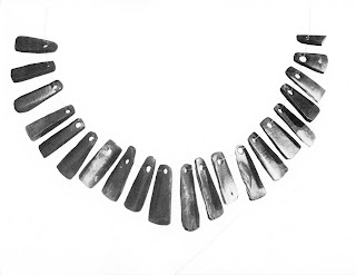
Single course Fremont bone plaque necklace, from
Exploring the Fremont, David B. Madsen, 1989,
Utah Museum of Natural History, p.41.

The main anthropomorph in the upper left quadrant of the photo is composed of nearly 300 dots with some form of elaborate winged headdress, eyes, a mouth, ear pendants, and a seven plaque bone necklace incised into the cliff surface. This style of necklace is quite common in the portrayal of individuals in the Classic Fremont Style rock art and numerous examples have been recovered. Below the necklace can be seen a belt or waistband as well.

What is the most remarkable about these petroglyphs, however, is the technique used to create them because they are created from lines of many dots that seem to have been drilled into the rock. As I said above, given the lie of these petroglyphs I could not get into a position to examine them closely, but given the apparent depth, and consistent size and roundness of these dots I assume that they are drilled holes. Even if these are created on sandstone rather than much harder stone like basalt, drilling this many holes represents an awesome amount of work.

Originally these figures might have been painted as well, as many Classic Fremont Style figures from this area included both pecking and paint, indeed traces of paint can still be found on many of them. Some of these are located at other sites in Dinosaur National Monument and many others at nearby McConkey Ranch north of Vernal, Utah.

In any case they represent a truly unique example in North American rock art.

Friday, October 8, 2010

THE GOLDEN RATIO IN ROCK ART:

Hunt panel, 9-Mile Canyon, Utah.
Photo: Peter Faris, 1985.

On April 17, 1987, I presented a paper at the Rock Art in the Western United States symposium at the Denver Museum of Natural History, co-sponsored by the museum and by the Colorado Archaeological Society. My presentation was titled Aspects of Design in Uintah and San Rafael Fremont Rock Art. In this I focused on analyzing rock art in terms of traditional design concepts in western art. Note that I was discussing rock art that predates any possible contact between cultures. In this I was postulating that preference for certain proportions and ratios are apparently hard-wired into the human brain. One of the design elements that I discussed on that occasion was the golden ratio (AKA: golden mean/golden section).
The golden ratio was of great interest to early mathematicians and has been used intentionally at least since the Renaissance by western artists as a basis for composition. Simply speaking, the golden ratio is a means of subdividing a line or an area in such a way that the ratio of the smaller portion to the larger is the same as ratio of the larger portion to the total. According to Wikipedia “two quantities are in the golden ratio if the ratio of the sum of the quantities to the larger quantity is equal to the ratio of the larger quantity to the smaller one. The golden ratio is an irrational mathematical constant, approximately 1.6180339887.”

In 1945, Max Raphael wrote in Prehistoric Cave Paintings that “The first surprise of the spectator who takes measurements is not that he finds proportions in all these lines and surfaces, but that these proportions – largely independent of the various animal species represented – can be reduced to a few recurrent types such as 1:1, 1:2, 2:3, 2:5, 3:5, 3:4, 3:7 and 4:7. The first two require no explanation because they can be achieved with any scale. The next three form the homogeneous group 2:3 = 3:5 which is known as the golden section” (p.28).

Raphael believed that early man had become aware of this ratio by noticing natural relationships of the digits of the human hand. His candidate for this relationship was the that the ratio of the width of the 4th and 5th fingers on one hand compared to the width of the thumb plus the 1st and 2nd fingers closely approximates the ratio of the width of the thumb plus the 1st and 2nd fingers to the width of all five fingers. Raphael also found the golden section in the body proportions of many of the animals portrayed in cave paintings.

Golden ratio proportions drawn on photo,
Hunt panel, 9-Mile Canyon, Utah.
Photo: Peter Faris, 1985.

The example that I presented for the golden ratio is the famous hunting panel from 9-Mile Canyon in northeastern Utah. In examining this petroglyph panel we first recognize that there are elements from more than one culture included and my analysis was focused on the original Fremont composition. It is obvious that the original composition composed a panel of the type that is sometimes called a “master of the animals” or “master of the hunt” composition. The classic Fremont figure on the upper center of the composition (often assume to be a hunt shaman) is surrounded by a grouping of quadrupeds which appear to be bighorns. These animals are all connected to each other and to the upper human figure by overlapping, and in some instances lines. Six or seven figures have been added later in a different style, predominately on the right side. Four of these are hunters carrying bows and were created at a later date with a more fluid and curving style by another hand and which would not have been part of the original composition. There are also shield figures which may be questioned but their presence does not change the proportions of what I take to be the original composition which consists of the upper central Fremont figure and the grouping of bighorns around him. When I focus on that, the ratio of the width to the height can be seen to be very closely comparable to the golden ratio. I believe that this was probably done subconsciously by the original Fremont artist. These proportions just “felt right” to the creator of the panel. Later figures were probably added to share the supposed spiritual power possessed by the panel. I believe that this ratio represents one of the elements in rock art that is not generally intentional, but comes from a common inherited, subconscious, human sensitivity to that ratio which is hard-wired into the human brain, possibly as a relic of our primate brain’s need to judge distances and proportions in the branches of the trees that housed our early ancestors.

This points toward at least one element that can be recognized in rock art that is attributable to our common humanity rather than cultural influences or stylistic choices, but I believe there are many other such elements.

REFERENCE:

Raphael, Max
1945   Prehistoric Cave Paintings, Pantheon Books, Washington D.C.

Tuesday, September 28, 2010

COUP COUNTS IN ROCK ART – CONTINUED:

On September 28, 2010, I posted a column on portrayals of coup counts in rock art of the northern Great Plains. In this I showed examples of lines of rifles that researchers assume represent weapons captured from some enemy group, and also mentioned examples which illustrate a row of bows or tomahawks that are assumed to represent the same thing. Another example that might be postulated is a row or column of arcs assumed to represent horse hoof prints and have been suggested to represent the coups of a group of horses stolen in a horse raid.


Field sketch, 5BN7, Hicklin Springs, Colorado,
by Peter Faris, 25 September 1993.

One example of this type of portrayal can be found at Hicklin Springs (5BN7) in southeastern Colorado. Toward the bottom of this panel twenty four curved arcs resembling horse hoof prints can be seen aligned in four vertical columns. This has been interpreted as representing a record of a successful horse raid in which the raiding party returned with two dozen captured horses and the bottom portion of this panel represents a record of this.

One problem with this interpretation is the style of pecking itself. These are fairly deeply pecked with no abrading and in this area that type of petroglyph usually predates the early historic period during which the horse became available to people on the southern Great Plains. Deeply pecked petroglyphs in this area are generally prehistoric; historical era imagery in this area is usually incised. This could mean that the panel of “U” shaped symbols does not represent horse hoof prints at all, but then if that is the case, what do they represent? The deep pecking could, of course, represent an anomalous technique that was created later, but in the earlier style.

COUP COUNTS IN ROCK ART:

James Keyser has convincingly written about similarities between much proto-Historic and Historic Plains Indian rock art and the imagery drawn and painted in ledger books, on war shirts, and buffalo robes by the same Plains Indian warriors. Indeed he has called the pictures in ledger books, and on war shirts and buffalo robes a “lexicon of symbols” that can be applied to the interpretation of much rock art of the northern Great Plains.
Line of red rifles, coup count from Pictograph Cave,
southeast of Billings, MT. Photo: Peter Faris, 2009.

A group of rifles in a line painted in red can be seen at Pictograph Cave southeast of Billings, Montana. A grouping such as this is generally interpreted as coups based upon comparisons with paintings of war shirts, buffalo robes, and ledger books painted by warriors of Plains Indian tribes to advertise their exploits in combat. The assumption is that these represent weapons that were captured in battle. Another such grouping drawn in black can be seen at Farrington Springs in southeastern Colorado.

Line of black rifles, coup count, Farrington Springs,
Colorado. Photo: Peter Faris, 2002.

In other instances and locations examples of rows of bows or tomahawks lined up in the same way can be seen which are also assumed to represent coup counts. If this is the case we can also assume that this represents an older example, predating the acquisition of enough firearms to picture in such groupings. The rifle groupings also provide hints to dating in that many of the known groupings portray flintlock rifles as seen in the examples from Montana and southeastern Colorado.

39FA79, from p.111, Linea Sundstrom, Storied Stone,
Indian Rock Art of the Black Hills Country, 2004.

In the Black Hills, Linea Sundstrom has recorded what is, if she is correct, the largest known panel representing counted coups. Containing almost 30 rifles, and 119 schematized human figures lined up in similar rows (in the same format as the coup counts) the top portion of panel 39FA79 also shows scenes of combat supposedly recording some of the brave deeds performed by the warrior who created the petroglyph panel. The figures supposedly represent the bodies of enemies killed in combat, and because of the large number of them in this example Sundstrom suggests that this panel might represent the members of the 7th Cavalry killed at the Battle of the Little Big Horn by members of the Cheyenne and Lakota tribes.

Many other examples of this theme exist in North American rock art. Indeed other symbols can sometimes be postulated as coup counts as well. More on this later.

Wednesday, September 22, 2010

A GEOGLYPH IN SOUTHEAST COLORADO - THE MAN WITH THE SPEAR:

In southeastern Colorado, south of the town of Limon, a geoglyph composed of rocks placed to form am image has been located. This rock alignment is in the form of a man carrying a spear or long staff. I was given a photo of this image about 8 years ago by Ted Barker who I believe had taken it while standing on the hood of his pickup to get as high an angle as possible. I know of no true overhead picture of the image which would show it in clear outline. At the angle that we view this from the image is greatly distorted by perspective and it is somewhat difficult to recognize from this angle but all who have seen it seem to agree that it is the outline of a man carrying a spear or long staff made out of rocks.


Man with spear geoglyph, southeastern Colorado. Photo: Ted Barker.

As far as I know this has never been formally recorded and no tests have been conducted of the site. Thus we have no actual data as to its provenience. So who made it, and why? The fact that the figure is pedestrian, not mounted on a horse, suggests that it might be prehistoric or at least proto-historic. The rocks seem to be well seated in the ground, not sitting up on the surface, so that might suggest age. This is hard to say, however, since we do not have a geomorphologic study of the site we do not know what processes might have been at work. Are natural processes slowly sinking the rocks into the ground with the passing of time, or could wind erosion be removing surface particles of dirt to counter that process?

One can only hope that someone will complete a formal study and recording of the "man with a spear" geoglyph before a pickup truck drives across it or a bunch of the rocks are rolled away, and if you do please let me know.


Monday, September 13, 2010

AN OBELISK IN PURGATOIRE CANYON, SOUTHEASTERN COLORADO, REVISITED:

On June 30, 2009, I posted a column entitled AN OBELISK IN PURGATOIRE CANYON, SOUTHEASTERN COLORADO. In this I presented a picture of a tall rock column with petroglyphs carved into the surface which had been erected vertically by someone in the past. In the text I mentioned that although my photo showed it with the top broken off, the broken portion of it was found at its base when I first visited the site.

Southeast Colorado obelisk. Photo: Jim Whitall.

I recently ran across an earlier photo of the obelisk that had been published by Bill McGlone, Phil Leonard, and Ted Barker in their 1999 book Archaeoastronomy of Southeast Colorado and the Oklahoma Panhandle. This earlier photo had been taken by Jim Whitall, and shows the obelisk with the petroglyphs enhanced on the surface of the stone. At that period McGlone and Leonard were in the practice of enhancing petroglyphs by painting the markings with a solution of powdered aluminum in distilled water, a practice that was thought to be harmless to the petroglyph. They abandoned that practice soon thereafter when the dating petroglyphs by analysis of their patina began to look possible.

In this early photo the largest broken portion of the obelisk had been placed back on top of it and the petroglyphs were enhanced with this aluminum powder mixture for increased visibility. A smaller fragment has also been replaced on the top but this fragment does not appear to have any portion of the petroglyphs on it. With the broken pieces back in place this early photo of the southeast Colorado obelisk does give a much better appreciation of the appearance of the original and the enhanced petroglyphs are more clearly visible This interesting phenomenon is essentially unique, at least I know of no other examples in this area.

Although, in this photo it looks as if it might be leaning against the rock behind it they are actually separated by a few feet and the column is truly free standing. I will be very interested to see any other examples of similar carved and erected stones from other locations. If you know of one please contact me. Thank you.

Monday, September 6, 2010

THE TOMB OF REKHMIRE – A DWARF MAMMOTH IN ANCIENT EGYPT?

Rekhmire was “Governor of the Town” of Thebes, and the vizier of Egypt during the reigns of Tuthmose III and Amenhotep II (ca. 1479 to 1401 B.C.E.) during the XVIII dynasty (Wikipedia). This made him the most powerful official in the civil administration during that period of the Egyptian empire’s greatest extent and prosperity. As the most powerful official he rated a large and highly decorated tomb in the Theban necropolis. The illustrations include many illustrating Rekhmire’s duties for the Pharaoh and provide an invaluable record of his duties and daily life for the court.

Wall mural from the tomb of Rekhmire showing
tribute bearers. The giraffe is at upper right and
the miniature elephant following the bear is at
the lower left.

One wall of his tomb shows Rekhmire supervising the collection of tribute to the Pharaoh from foreign emissaries. Rows of figures bearing tribute are illustrated divided by nationality. The top row shows tribute from the land of Punt and includes myrrh, gold, precious stones and ivory, a baboon, monkeys and exotic animal skins. The next row down records the tribute from Mediterranean islands including Crete. These bearers are dressed in Mycenaean kilts. Next in order is a row of Kushite (Nubian) tribute bearers with representative animals including a giraffe, leopard, baboons, monkeys, cattle and dogs, as well as ostrich eggs and feathers. The next in vertical order represents the tribute from Syrians dressed in long white robes and pointed beards with wagons and horses, a bear, and an elephants, weapons and metal vessels, copper ingots and pottery.

Because of space constrictions on the tomb wall these portrayals are shown in a rough echelon of scale, the larger animals are shown as larger than smaller species, but not to full proportion. The tallest animal is the giraffe which stands a little taller than the Nubian leading him. Other animals shown are scaled roughly in proportion down from the giraffe based upon their relative sizes, with one notable exception, the elephant. The elephant is little larger than the bear which precedes it in procession. That makes the elephant the most interesting animal in the tomb and it also brings up a fascinating question. What kind of elephant is it anyway?

Wall mural from the tomb of Rekhmire showing
the miniature elephant following the bear.

There actually was, at this time, a resident population in the Syrian area of a native elephant, the Syrian elephant, Elephas maximus asurus. The most extreme western population of the Asiatic elephant, this became extinct in ancient times by around 100 BC. This was also the largest sub-species of the Asian elephant, standing up to 3.5 meters tall (11½ feet). This size provides a problem with the elephant in the tomb painting. It is portrayed as waist high on its handler, and given the relative sizes of the animals shown it should have been considerably larger in scale like the giraffe on the register above it, - perhaps it is a baby Asian elephant. It seems to portray some features that could belong to an Asian elephant, the domed head and small ears. It cannot however be intended as a baby elephant of any kind because it has a pair of impressively long tusks which would be huge if scaled up to full size. Such tusks could only be meant to represent a fully grown adult animal. There is one other puzzling feature about the elephant in Rekhmire’s tomb, it seems to be covered with hair (compare the portrayal of the elephant’s surface with the bear in front of it). What kind of elephant had small ears, a domed head, huge tusks, and a covering of hair?

The only elephantid with the domed head, small ears, huge tusks, and covered with hair that I can think of was the wooly mammoth (Mammuthus primigenius). But, in ca. 1479 to 1401 B.C. how could they have seen a mammoth to portray in Rekhmire’s tomb.
According to Wikipedia, “during the last ice age, woolly mammoths (Mammuthus primigenius) lived on Wrangel Island in the Arctic Ocean. It has been shown that mammoths survived on Wrangel Island until 1700 B.C.E., the most recent survival of any known mammoth population.” This time frame is close enough to the 1479 B.C.E. of the beginning of the reign of Tuthmose III to make me wonder. The latest date from dwarf mammoth remains on Wrangel Island (1700 B.C.E.) surely does not represent the last individual to perish, so many must have lived longer. That makes it conceivable to imagine an overlap in time between the existence of dwarf mammoths on Wrangel Island, and the creation of Rekhmire’s tomb. Could a representative captive sample of Wrangel Island dwarf mammoths actually been traded from far northeastern Siberia to Syria, to be presented to an Egyptian pharaoh as tribute? Stranger things have happened.

Tuesday, August 31, 2010

ROCK ALIGNMENTS IN SOUTHEASTERN COLORADO:


Rock Alignment, Baca County, CO. The middle
rock in this picture is behind the clump
of weeds. Photo: Peter Faris, 1988.


In Baca County, in southeastern Colorado, a very interesting phenomenon is represented by a large number of rock alignments. Straight lines of various sized rocks carefully laid out across the landscape in almost perfect rows, some for considerable distance. The longest that has been reported to me is approximately one-half mile in length. There does not seem to be any discernible pattern to their layout or locations. Some go up hills and down, others up the center of a valley between two hills. These occur over a larger area than just Baca County, Colorado. A few years ago I was told by a rancher from near Boise City, OK, that he had them in that area as well.


A Native American informant reportedly told some investigators that these rock alignments represented escape routes, where members of a threatened tribe could sneak away without leaving any footprints by walking on the rocks like stepping stones. This is patently silly as you would not need to follow footprints to find your quarry if they obligingly had left you a trail of stepping stones to follow, much more durable and easier to see than bread crumbs.

So what is the purpose for these alignments? I truly do not know. As usual these things are “discovered” when they become known to modern science, no matter who knew about them before. Investigators have made much about the fact that they supposedly can only be “seen from above.” Well it is possible that they were made as some sort of spiritual activity, if the labor of creating these lines was an offering to the spirits. That does not fit very well with anything we know about Native American religions. That suggestion does occur to us because it fits well with many of the religious traditions of the dominant western culture. Carved stone saints standing in niches in European cathedrals are fully finished in the back even though no member of the congregation will ever see that back, because God knows whether or not it is complete, and less than complete is thought to be less than satisfactory to God.

We are faced with an unknown here and much serious study will be required to gather more information. Until then, I am open to suggestions.

Tuesday, August 24, 2010

A BIGHORN SHEEP/RAINBOW PETROGLYPH:

On an August afternoon in 2003, friends Bill and Jeannie guided us to visit the Mortandad Ruin near Los Alamos, NM. The remaining ruins consist primarily of a cliff of cavates, rooms excavated into relatively soft volcanic tuff. There is also a considerable amount of rock art, some of it petroglyphs pecked into the cliff walls, and some of it images carved into the smoke-blackened walls of cavates, exposing the light colored tuff beneath. A probable sun symbol in one caveate consists of a circle around a dot (a haloed sun) with approximately sixteen short tic marks on the inside of the circle pointing roughly toward the central dot. Another haloed sun symbol petroglyph carved near the top of the cliff consists of approximately six concentric circles around a central dot.

While inspecting a cloud petroglyph on a generally southwestern-facing point near the top of the cliff I realized what a marvelous weather-spotting point this actually was. I could see a thunderstorm clearing the canyon rim far down the broad valley, bringing refreshing rain to a hot summer afternoon on an arid and sun-facing cliff, and which seemed to fully explain the cloud petroglyphs in that location.

Bighorn sheep petroglyph with a rainbow
on his left horn. Mortendad ruin, New Mexico.
Photo: Peter Faris, August, 2003.

On September 16, 2009, I did a posting about that weather-watching station and the weather-related rock art found there. Also found in that weather-watcher’s station, near the cloud petroglyphs, a small and carefully carved rainbow reminds us of the joyful conclusion of this refreshing summer rain. This rainbow is carved on the left horn (to our right) of the head of a bighorn sheep. This head with horns is presented in the relatively unusual aspect of a frontal view, instead of the usual side view of the sheep’s head. Heart shaped petroglyphs on the right side of the panel represent other sheep’s heads seen in frontal view, but only the one on the left has the rainbow carved into his left horn. So is there a connection between bighorn sheep and rainbows that could help explain this image?

Close-up of bighorn sheep petroglyph with a rainbow
on his left horn. Mortendad ruin, New Mexico.
Photo: Peter Faris, August, 2003.

In Landscapes of the Spirits: Hohokam Rock Art at South Mountain Park (2002), archaeologist Todd Bostwick wrote about the meteorological connotations of bighorn sheep in the American southwest. “Ethnographer Amadeo Rey has noted that no other animal was treated with such awe and reverence by the O’odham as the mountain sheep. Called “Cheson” by the Northern Pima, the bighorn sheep was closely associated with the wind. Some villages had shrines dedicated to the wind and Cheson. Parts of the mountain sheep are very powerful; both the hides and horns must be kept in a safe, respected location to avoid insulting the wind and bringing on violent storms.” 

Thus we have the fact of the conjunction of bighorn sheep head and rainbow symbol, in a location which seems to be devoted to weather watching, and mythological connections between bighorn sheep and weather in the American Southwest, all suggesting that the curved lines superimposed on the bighorn sheep’s left horn are indeed representative of a rainbow.

Reference:
Bostwick, Todd W., Landscapes of the Spirits: Hohokam Rock Art at South Mountain Park, 2002, University of Arizona Press, Tucson.

Saturday, August 14, 2010

REPTILES IN ROCK ART - A HORNED LIZARD PETROGLYPH ASSOCIATED WITH A SOLSTICE SUNSET ALIGNMENT:

Horned Lizard Petroglyph, p. 53, Astronomy
Magazine, April 2010, Winter solstice sunset
in notch in Sierra Estrella mountains.

Among rock art sites with solar alignments in South Mountain Park in Phoenix is the site illustrated with a sunset alignment. These rock art sites are identified as having been created by the Hohokam people.
City of Phoenix archaeologist Todd Bostwick photographed a winter solstice sunset with the sun’s disk disappearing into a notch in the Sierra Estrella mountains to the West from one site. Remarkably, the viewing point at this site is a pointed boulder with a petroglyph of a thick-bodied horned lizard, facing downward pecked on the face of it. If there were mythological connections between the setting sun and a horned toad/lizard this would be a remarkable piece of evidence.


Regal Horned Lizard, p.49, Wade C Sherbrooke,
Introduction to Horned Lizards of North America,
2003, University of California Press,
Berkeley and Los Angeles.


In his 2003 volume Introduction to Horned Lizards of North America, Wade Sherbrooke stated (p.149) that Hohokam art clearly depicted two species of horned lizard, the Short-horned lizard, and the Regal Horned lizard. Both of these species are found throughout the area inhabited by Hohokam peoples. The Latin name for the Regal Horned lizard is Phrynosoma solare, from the Latin solaris for “belonging to the Sun”.
These heat-loving lizards retire from the evening cool and the cold of the night by retreating into underground burrows or burying themselves in the sand. This may well be reflected in the downward facing position of the horned lizard in the picture of the Gila Vista site, implying the retreat of the lizard at the sundown being observed through this alignment, and possibly identifying this image as the Regal Horned Lizard.

REFERENCES

Bostwick, Todd W.
2002   Landscape of the Spirits, Hohokam Rock Art at South Mountain Park, photographs by Peter Krocek, University of Arizona Press, Tucson.

Sherbrooke, Wade C.
2003   Introduction to Horned Lizards of North America, University of California Press, Berkeley and Los Angeles.