Showing posts with label geoglyph. Show all posts

Saturday, May 17, 2025

GEOGLYPHS OF THE BLACK DESERT OF JORDAN - PART 2: VIRTUDES PONTES SANCHEZ' THEORY:

Geoglyphs, Black Rock Desert, Jordan. Note the varying number of subdivisions.

A series of very interesting geoglyphs stretch across a volcanic wasteland known as the Black Desert of Jordan. I was made aware of these when I received a communication from Tomás Tarjuelo Palomino, a collaborator introducing me to the theory of Spanish researcher Mrs. Virtudes Pontes Sánchez who has been studying the geoglyphs. In the following paragraphs I will present the geoglyphs and then go into the theory of Mrs. Sánchez and Mr. Palomino.

These geoglyphs have occasionally been lumped into the same category as the ‘desert kites (see Note below)’ that I have written about previously. This should not be accepted, however, as the ‘desert kites’ are obviously traps for hunting antelope and these particular geoglyphs purposes are unknown, but none of them seem to have a shape that would function as an effective animal trap. Were they residences, temples, tombs or fortifications, nobody seems to currently know.

The marvelous geoglyphs of the Black Rock Desert of Jordan and surrounding areas are mysterious for two basic reasons. The first would be lack of study, not enough research has been done to determine what they were intended for. The second is their tremendous variety which seems to belie a commonality of purpose. Their internal structures are so variable.

These differences, which puzzle a linear thinker like me, seem to be exactly what inspired the unique theory of Mrs. Sanchez as communicated to me by Mr. Palomino.

Egg cell (Oocyte) immediatly after fertilization.

In her own words Mrs. Virtudes Pontes Sánchez described her reactions to seeing the geoglyphs. “In the Jordanian Black Desert several circles can be clearly distinguished thanks to the technological development which makes effective the high-definition photographing from satellites. Said circles compound specific geoglyphs and are created with stones of basalt Furthermore, they are still a matter of speculation by archaeologists, who have speculated about different theories and scopes. However, no archaeologist has a clear idea of what they really represent and their finality. When I saw those images and after my experience of more than 28 years researching the ancient scripture and the megalithic archaeology I realized what the above mentioned circles of basalt are and the role they fulfill.” (Palomino and Sanchez 2025) The letter was accompanied by screen shots from Google Earth of a large number of the geoglyphs, as well as microscopic views of developing embryos.

First division of fertilized egg cell.

As I said, when seen from above, the geoglyphs reminded Mrs. Sanchez of developing embryos as seen through a microscope. “The concerned geoglyphs constitute maps of embryonic experiments, and if you pay close attention to the picture you will realize the result of two species: one is human, whereas the other is reptilian. The five embryos located on the left side of the picture are human, whereas the remaining embryos are reptilian. They show the embryonic development until they become blastocyst.” (Palomino and Sanchez 2025)

Further division into three cells.

“As you can see, the pictures representing the geoglyphs and the latter pictures are the same kind of pictures. Both display embryos in development, with the difference that the geoglyphs located on the desert are dated 8,500 years old pursuant to the archaeologists.” (Palomino and Sanchez 2025)

Eight cells.

More than just embryos, Sanchez also sees stem cells in some of the shapes. “These geoglyphs are not only situated in the Jordanian desert, but also in more countries, as well as around the area where the ancient scriptures speak of the Garden of Eden. There are geoglyphs representing stem cells as well, such as these appearing on the next pictures.” (Palomino and Sanchez 2025) So, in these images of the geoglyphs seen from above they see a biology text essentially about conception.

They also accept that there is still a great deal to learn about these constructions. “There is, in fact, much more in said vast area than you can imagine, ‘till a good explanation is issued about the reason of their composition of stones of basalt. There are plenty of images able to prove that we all were created here and that there is no theory of evolution. The ancient scriptures are right in saying there is creation.” The fact that these structures are composed of basalt would be basically the fact that the ‘Black Desert’ is named for vast fields of volcanic basalt that once flowed across the area.

Developing embryonic blastocyst.

So, in summation, Sanchez and Palomino see the shapes in the Black Desert in Jordan as diagrams of biological forms, embryos and stem cells, and from this they believe that they have proof of the Creation. One comment I would make to this is that one of the things I enjoy about rock art is a lack of dogma so there is room for a number of theories. My other comment would be to repeat that I do not personally have an explanation for their tremendous variety which seems to belie a commonality of purpose. Their internal structures are so variable. As a result of this I feel compelled to state that I do not know what they are either. As I stated in a previous column my best guess would be that they represent walled family or clan compounds that contained residences and pens for their flocks. In such a case the size might denote the number of people and animals being housed. But, until I know a better answer, I will let Mrs. Sanchez’ and Mr. Palomino’s statement stand without further comment.

NOTE: So-called ‘Desert Kites’ have been mentioned in two previous columns on RockArtBlog.

  • 29 July 2023, 9,000 Year Old Petroglyphs Copy Designs of Mega-Scale Desert Animal Traps. https://www.blogger.com/blog/post/edit/7760124847746733855/8126054377764858401.

NOTE 2: The microscopic pictures of developing cells were provided by Tomas Tarjuelo Palomino, and Virtudes Pontes Sanchez with no citation of their original source. Thank you.

REFERENCES:

Tomás Tarjuelo Palomino, 24 January 2025, Personal Communication.

Virtudes Pontes Sánchez, 2021, Groundbreaking Archaeological and Scientific Discovery in the Jordanian Black Desert, 1 October 2021, https://operationdisclosureofficial.com. Accessed online 9 February 2025.

Saturday, March 8, 2025

GEOGLYPHS – A SERPENT INTAGLIO IN KANSAS:

The Great Serpent Mound, Peebles, Ohio. Gettyimages.

Most people know of the Great Serpent Mound at Peebles, Ohio. Less well known is a smaller serpent intaglio in Rice County, near Lyons, Kansas. Like the Ohio serpent mound, the Kansas serpent is portrayed as swallowing an egg.

Rice County Serpent Intaglio. The Wichita Eagle, November 11, 2014.

“This manmade curiosity represents an enormous serpent in the act of swallowing an egg. It is one of the best-preserved Indian carvings still around. In Kansas, there are only two, said Janel Cook, the director of Lyons’ Coronado Quivira Museum. They call it the Serpent Intaglio.” (Bickel 2008) The Quivira people were believed to be the predecessors of the Wichita tribe.

“Ancestors of the Wichita tribe cut this 160-foot-long image of a serpent into the sod of Rice County roughly 600 years ago. This photo was taken in the 1980s when an archaeologist poured biodegradable lime into the cut to highlight the shape. In Gary Miller’s Rice County cow pasture, miles from anywhere, there’s a long depression in the prairie grass that zig-zags along the western slope of a ridge. It’s a faint image, only inches deep. But in springtime, wild onions grow in an egg-shaped circle at one end. And in 1983, a scientist named Clark Mallam poured lime into the zig-zag and had an airplane fly over to take a photo. The yellow lime contrasted with the pasture grass and revealed the image of a serpent, 160 feet long, jaws closing around an egg.” (Wenzl 2014) The fact that different vegetation grows there than in the untouched ground around it suggests that the soil is different, or has perhaps been treated some way to give it different properties. “Apparently a different kind of soil was put into the snake,' said Kermit Hayes, a neighboring farmer. 'Short buffalo grass is about all that will grow there. Grasses such as bluestem and western wheat grass cover the pasture around the trench.”(Blosser 1982) So the modified soil is affecting growing conditions and make the serpent detectable.

Close-up of the serpent intaglio and vegetation differences. Online image, public domain.

This geoglyph or intaglio has been visited by archaeologists, but apparently it has not yet been studies in detail. “Dr. Clark Mallam, a visiting archeologist, says the jaws of the serpent point northwest toward the remains of ancient Quivira Indian villages two miles away. 'Dr. Mallam isn't saying positively, but it looks like the Indian villages were all under the influence of the serpent,' Ernst said. 'Dr. Mallam says, 'Here is the serpent and here is the Garden of Eden,'' Ernst said, pointing to a map of the villages in a fertile valley of the Little Arkansas River. The consensus is the hilltop discovery, which local residents refer to as 'the snake' or by its technical name, 'the intaglio,' which means a design or figure carved or engraved into a hard material, is one more Quivira relic which has withstood the elements.” (Blosser 1982) Dr. Mallam was a professor of anthropology at Luther College in Decorah, Iowa, who specialized in studying Native American mounds and geoglyphs.

The curator of the Lyons, Kansas museum, Clyde Ernst, has reported that the members of the Wichita tribe have not provided any insight into the meaning of the serpent in their beliefs (BLosser 1982). The image of a serpent swallowing an egg must have had spiritual significance to all these people, possibly portraying an eclipse.

NOTE: Some images in this posting were retrieved from the internet with a search for public domain photographs. If any of these images are not intended to be public domain, I apologize, and will happily provide the picture credits if the owner will contact me with them. For further information on these reports you should read the original reports at the sites listed below.

REFERENCES:

Bickel, Amy, 2008, LYONS – On a hill amid the pasture, something mysterious emerges from mixed-grass prairie, 9 August 2008, The Hutchinson News, Hutchinson, Kansas. Accessed online 3 January 2025.

Blosser, J.B., 1982, Apparent ancient Indian symbol snakes across Kansas pasture, 17 September 1982, UPI Archives online. https://www.upi.com/Archives/1982/09/17/Apparent-ancient-Indian-symbol-snakes-across-Kansas-pasture/4598401083200/. Accessed online 3 January 2025.

Wenzl, Roy, 2014, Wichita State anthropologist hopes to unearth a Plains people’s lost story, 11 November 2014, The Wichita Eagle. Accessed online 3 January 2025.

Saturday, June 22, 2024

ANOTHER UNDERWATER DRIVELINE – THE DROP 45 SITE IN LAKE HURON:

About a utilitarian geoglyph for hunting animals.

North American Laurentide ice sheet. Illustration from Pinterest.
Laurentide ice sheet, Illustration from smithsonianmag.com.
Map of the Cordilleran and Laurentide ice sheets. Online image, public domain.

It is easy to overlook, or forget, that the glacial periods had so much water locked up in ice that considerably more territory was available to prehistoric humans. Not only at continental margins, but where large lakes now exist, land was exposed and, no doubt, lived on and utilized by the populations. With the last melting of glacial ice this water was released and raised water levels considerably. This means, of course, that many traces of prehistoric life and activities are now underwater.

“Some of the most pivotal questions in human prehistory necessitate the investigation of archaeological sites that are now under water. The advance and retreat of glacial ice throughout the period of human development and dispersal, and the associated global changes in sea level, repeatedly exposed, and then submerged, significant coastal land masses. As a result, questions as diverse as the origins of early human culture, the spread of hominids out of Africa, and the colonization of the New World all hinge on evidence that is under water. Although the discovery and investigation of such sites presents methodological challenges, these contexts also have unique potential for preserving ancient sites without disturbance from later human occupation. The Alpena-Amberley Ridge (AAR) beneath modern Lake Huron in the North American Great Lakes provides just such a setting.” (O’Shea, et al. 2014:6911)

Diagram of Drop 45 Site beneath Lake Huron. Illustration from O'Shea et al., 2014.

During the last glaciations, before the birth of the Great Lakes, paleoIndian hunters roamed the area and left traces of their existence. “Since 2008, more than 60 stone constructions on the AAR have been identified and visually inspected within two targeted research areas. Targets of potential interest identified during acoustic survey are examined via video provided by a remote operated vehicle (ROV) and, if warranted, are directly mapped and sampled by self-contained underwater breathing apparatus (scuba)-trained archaeologists.” (O’Shea, et al. 2014:6911) These investigations are now made possible by the development of the new technologies.

Blinds and drive lines seen from above. Drop 45 Site beneath Lake Huron. Illustration from O'Shea et al., 2014.

“Underwater archaeologists have discovered evidence of prehistoric caribou hunts that provide unprecedented insight into the social and seasonal organization of early peoples in the Great Lakes Region. An article detailing the discovery of a 9,000-year-old caribou hunting drive lane under Lake Huron appears in today’s issue of the Proceedings of the National Academy of Sciences. ‘This site and its associated artifacts, along with environmental and simulation studies, suggest that Late Paleoindian/Early Archaic caribou hunters employed distinctly different seasonal approaches,’ said John O’Shea, the Emerson F. Greenman Professor of Anthropological Archaeology and lead author of the article. ‘In autumn, small groups carried out the caribou hunts, and in spring, larger groups of hunters cooperated.” (Swanbrow 2014)

Rollins Pass drive line, Grand County, Colorado, 25 July 1987, 1 mile of fence, 174 pit blinds and 184 cairns, ca. 6,000 - 3,000 BC. Photograph Peter Faris, 1987.

Although a low stone wall could have been easily crossed by the game animals, the appearance of such artificial features on the landscape seemingly make the animal uneasy, they tend to turn aside and parallel such a wall instead of crossing over. The high-altitude Rocky Mountain archaeologist James Benedict once told me about watching a deer approach a linear stone feature on Rollins Pass in the Colorado Rockies. Although the stone line is basically only one stone high nowadays the deer turned aside instead of crossing it. (Benedict, Personal communication, 1987)

Diver recording a hunting blind, Drop 45 Site beneath Lake Huron. Illustration from O'Shea et al., 2014.

Drop 45 Site beneath Lake Huron. Illustration from O'Shea et al., 2014.
Diver and underwater drone. Drop 45 Site beneath Lake Huron. Illustration from O'Shea et al., 2014.

“Researchers based at the University of Michigan think the roughly 9,000-year-old structure helped natives corral caribou herds migrating across what was then an exposed land-corridor – the so-called Alpena-Amberly Ridge – connecting northeast Michigan to southern Ontario. The area is now covered by 120 feet (37 meters) of water, but at the time, was exposed due to dry conditions of the last ice age.” (LiveScience Staff 2014)

“Paleoenvironmental analysis indicates that the area was a subarctic environment consisting of sphagnum moss, tamarack larch and spruce trees, along with small lakes, rivers, and wetlands. Radiocarbon dates on preserved wood yielded dates from 8,900–8,640 cal B.P., whereas charcoal recovered from the middle of a circle of small stones yielded a date of 9,020 cal B.P. The environment that emerges from these studies is one that would have been ideal for migrating caribou and for their human pursuers”. (O’Shea, et al. 2014:6911) I find it remarkable that we even have these hard dates for these features. Wonderful work.

NOTE: Some images in this posting were retrieved from the internet with a search for public domain photographs. If any of these images are not intended to be public domain, I apologize, and will happily provide the picture credits if the owner will contact me with them. For further information on these reports you should read the original reports at the sites listed below.


REFERENCES:

Benedict, James, 1987, Personal communication.

LiveScience Staff, 2014, In Photos: Hunting Structure Hidden Beneath Lake Huron, 28 April 2014, https://www.livescience.com. Accessed online 6 May 2024.

O’Shea, John M., et al., 2014, A 9,000-year-old caribou hunting structure beneath Lake Huron, Proceedings of the National Academy of Science (PNAS), 13 May 2014, Vol. 111, No. 19, 6911-15. Accessed online 6 May 2024.

Swanbrow, Diane, 2014, Prehistoric caribou hunting structure found beneath Lake Huron, 28 April 2014, https://record.umich.edu. Accessed online 6 May 2024.

Sunday, March 3, 2024

GEOGLYPHS - GIANT CHALK FIGURE OF HERCULES IDENTIFIED AS SAXON MUSTERING SITE:


Cerne Abbas Giant, near the village of Cerne Abbas, Dorset, England. Online image, public domain.

Some of the world’s most famous geoglyphs are the chalk figures found in England. The Uffington White Horse, the Long Man of Wilmington, and perhaps the most famous of all the Cerne Abbas Giant.

“The Cerne Abbas Giant was formed by cutting trenches two feet deep into the steep hillside and then filling them with crushed chalk. Some scholars believed the giant might date back to the Iron Age as a fertility symbol. Local folklore holds that copulating on the giant’s crotch will help a couple conceive a child, and there is an Iron Age earthwork known as the Trendle at the top of the hill in which the giant has been carved. However, there is no mention of the figure in a 1540s survey of the Abbey lands, nor in a 1617 survey conducted by the English cartographer John Norden.” (Ouellette 2021)

Chalk-filled trench of Cerne Abbas Giant. Online image, publlc domain.

“A study conducted in 1996 observed alterations in certain characteristics over time. It concluded that when originally carved, the figure had a cloak draped over its left arm and potentially held an object, speculated to be a severed head beneath it is left hand. Tests conducted by the National Trust in 2021 determined that the giant was carved in the Anglo-Saxon period between AD 700-1100, when the land was owned by the West Saxon royal family in the 9th Century and 10th Century.” (Milligan 2024)

Sculpture depicting Hercules, late Roman, Corbridge, England. Corbridge Roman Town Museum. Photograph Copyright Carole Raddato.

This figure has since been recognized as a representation of the Classical Hercules. The draped cloak and severed head align with Classical representations of the demigod.

“The club is the clue, according to the new study. Hercules was one of the most frequently depicted figures in the classical world, and his distinctively knotted club acted as an identificatory label, like the keys of Saint Peter or the wheel of Saint Catherine. Hercules’ signature mantle—his cloak—may have also been included in the original Cerne Abbas outline, draped over the giant’s free hand, the researchers hypothesize.” (Anderson 2024)

“A further study by researchers from Oxford University now suggest that the figure was a muster station for West Saxon armies during a period when Saxon kingdoms were in conflict with invading Vikings. According to the researchers, the giant’s position, protruding from a ridge and situated near major route ways, combined with nearby fresh water souces and the locality to a West Saxon estate made it the perfect mustering spot.” (Milligan 2024)

So, perhaps now we know.


NOTE: Some images in this posting were retrieved from the internet with a search for public domain photographs. If any of these images are not intended to be public domain, I apologize, and will happily provide the picture credits if the owner will contact me with them. For further information on these reports you should read the original reports at the sites listed below.

REFERENCES:

Anderson, Sonja, 2024, This mysterious Hillside Carving is Actually Hercules, Researchers Say, 2 January 2024, https://www.smithsonianmag.com. Accessed online 4 January 2024/

Milligan, Mark, 2024, Mystery of Cerne Abbas Giant solved?, 1 January 2024, https://www.heritagedaily.com. Accessed online 2 January 2024.

Morcom, Thomas and Helen Gittos, 2024, The Cerne Giant in Its Early Medieval Context, Speculum, Volume 99, Number 1, Published by University, https://doi.org/10.1086/727992. Accessed online 10 January 2024.

Ouellette, Jennifer, 2021, Archaeologists “flabbergasted” to find Cerne Giant’s origins a medieval, 12 July 2021, Ars Technica, https://arstechnica.com/science/2021/07/. Accessed online 10 January 2024.                                       


Saturday, October 24, 2020

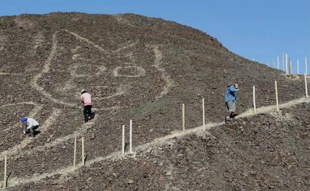
NEWLY DISCOVERED PARACAS CAT GEOGLYPH WAS LITERALLY UNDERFOOT:


Newly discovered and restored Paracas cat geoglyph, Peru. Internet photo, public domain.

The extensive geoglyphs in the Nazca valley of Peru, known as the Nazca lines were created by the removal of rocks covered with dark desert varnish leaving a lighter colored sandy soil beneath. The passing of millenia and natural erosion processes would tend to make these fade from view, especially if the image had been created on a hillside.

These famous Nazca lines are notoriously difficult to see. At ground level you can only see a small portion of whatever is around you, and you are not allowed to wander around freely among the images. In general the only satisfactory views are either from chartered airplane or from one of the viewing platforms providing a higher vantage point. One of these viewing platforms is on the small hill that sports the cat image. “Archaeologists came across the faded feline outline while conducting maintenance work at the UNESCO heritage site.” (May 2020) Proposed work to upgrade the path led to a closer look that identified the degraded geoglyph on the side of the hill. Upon a closer look workers identified the image of the cat, literally underfoot.


Newly discovered and restored Paracas cat geoglyph, Peru. Photo ancient-origins.net.


Relaxing cat, internet photo, public domain.


Newly discovered and restored Paracas cat     geoglyph, Peru. Photo ancient-origins.net.

“The Nazca lines, a Unesco World Heritage site, is home to designs on the ground - known as geoglyphs - created some 2,000 years ago. Scientists believe the cat, as with other Nazca animal figures, was created by making depressions in the desert floor, leaving coloured earth exposed. The cat then went unnoticed until plans were recently drawn up for a new path leading to an observation platform. The platform would have provided a vantage point for visitors to see many of the other geoglyphs.” (BBC 2020)


Newly discovered and restored Paracas cat geoglyph, Peru. Internet photo, public domain.

These geoglyphs were made possible by the special nature of the surfaces of the desert ground on the Nazca plain. A light colored soil is pretty much covered with very dark rocks stained by desert varnish. To create an image all the people needed to do was move some of the rocks aside to expose the light soil. However, over the ±2,000 or so years since the cats creation the wind had removed some of the soil and wind and earthquakes may have moved some of the rocks back to obscure the lines. Luckily the restoration process is fairly simple for these images. Once again the dark rocks are moved to the side exposing the lighter colored substrate beneath the rocks. 


Paracas woven textile cats. Internet photos, public domain.

“People created the giant cat figure between 2,500 and 1,800 years ago, according to the chief archaeologist for the Nazca Lines site, Johny Isla. He told Spanish news agency Efe that the cat looks very similar to cat motifs on textiles from the Paracas culture, which flourished in the area between 500 BCE and 200 CE - centuries before the Nazca culture, which usually gets the credit for most of the valley’s geoglyphs.” (Smith 2020)


Pampas Cat, leopardus colocola, Cincinnati Zoo. Public domain.

Since the Precolumbian Americas had no domestdicated cats, this animal represented a natural wild cat species found in the area. "Wild pampas cats, slightly larger than modern house cats, prowled the fields of the Paracas, attacking rodents and insects feeding on a wide array of cultivated crops." (Spivak 2020) Paracas farmers undoubtedly recognized the favor that these felines were doing them in controlling rodent numbers. An agricultural people in such an extreme environment would have been extremely aware of the loss of food to rodents, and they must have felt that wild cats, if not gods themselves, were sent by the gods to help the people. The artist in charge was obviously very familiar with these cats, however, to catch the relaxed pose so convincingly. The longitudinal and crosswise markings on the tail of the geoglyph subtly indicate the natural markings of the pampas wild cat.

Cats were a familiar subject matter to the Paracas people with many examples found in their pottery and weaving, attesting to their importance in the culture. 


Paracas pottery cats, internet photos, public domain.

This wonderful cat is now restored and should be good for another 2,000 years.

NOTE: Some images in this posting were retrieved from the internet with a search for public domain photographs. If any of these images are not intended to be public domain, I apologize, and will happily provide the picture credits if the owner will contact me with them. For further information on these reports you should read the original reports at the sites listed below.

REFERENCES:

May, Tiffany, October 19, 2020, 2,000-Year-Old Cat Etching Found at Nazca Lines Site in Peru, https://www.nytimes.com

Smith, Kiona N., October 19, 2020, A giant cat picture was just discovered among the Nazca Lines, https://arstechnica.com

Spivak, Deborah, July 8, 2020, A Paracas Textile Tribute to Cats, Cloth, and Death, Saint Louis Art Museum, https://www.slam.org

Staff writer, October 1-8, 2020, Large 2,000-year-old cat discovered in Peru’s Nazca lines, BBC News.

Saturday, August 10, 2019

AVIAN SUBJECTS IDENTIFIED IN NAZCA GEOGLYPHS: PART ONE – THE HUMMINGBIRD.


Hummingbird geoglyph, Nazca, Peru.
Photo Masaki Eda, used with
permission.

A favorite pastime of rock art researchers has long been trying to identify animal or plant images portrayed in rock art as to species or breed. This can have productive results in learning the appearance and physical characteristics of extinct species, or in gaining information as to the range of animals or plants during certain prehistoric periods, or give insight into the technology and cultural practices of the peoples who created the images. Now, a paper by non-rock art specialists has provided the identities of some of the birds portrayed in the geoglyphs of the Nazca desert of Peru. Masaki Eda, a Zoo-archaeologist, and self-described Archeo-ornithologist, from the University of Hokkaido in Japan, and his colleagues have applied their knowledge to analyze details in some of the bird geoglyphs and identify these with some degree of certainty and the results are somewhat surprising.


Hummingbird geoglyph, Nazca, Peru.
Photo Masaki Eda, used with permission.
Contrast enhanced by Peter Faris. 

In their report in the Journal of Archaeological Science they said “in this study, we identified bird geoglyphs in Nasca and Pampas de Jumana by noting any recognizable morphological traits. We then categorized the geoglyphs from an ornithological perspective and compared the identified characteristics with those of modern birds in Peru. In addition, we compared our identification results with those of other studies.” (p. 2)

“20 bird geoglyphs comprise the largest number of all geoglyphs that depict plants and animals at the Nasca and Palpa pampas. These geoglyphs are mainly considered to have been created during the late Paracas and the Nasca Period (c. 2400 to 1300 years ago).” (p. 1) Some of the figures previously listed as bird figures were virtually unrecognizable, either too distorted, incomplete, or too damaged to classify, but the researchers attempted to identify 16 of them. 


Koepcke's hermit hummingbird, Peru.
neotropical.birds.cornell.edu,
Public Domain.

The most commonly identified birds at Nazca are the hummingbirds. The first bird listed by Masaki et. al. is one of them. Lumbreras (2000) listed two bird geoglyphs as hummingbirds. “The bird geoglyph “3a” (BG-3a; Fig. 3a) was listed as a hummingbird (Lumbreras 2000) Its bill is notably long (almost as long as the rest of the body) and relatively thin compared to the width of the head. Short legs extend from either side of the body trunk, and each foot has three toes. The tail (with an elongated middle section) is almost as long as the body trunk. In the geoglyph, the bill is extremely long, and appears to be depicted in an exaggerated way. While hummingbirds (Trochilidae) have long bills, long tails, and short legs, these traits are also found in hacamars (Galbulidae). The feet of hummingbirds are anisodactyl (i.e., three toes face forward, and one faces backward), while those of the jacamars are zygodactyls (i.e., two toes face forward and two face backward). We, therefore, consider that geoglyph BF-3a more closely resembles hummingbirds. The family Trochilidae consist of typical brightly-colored hummingbirds (Trochilinae) and dull-colored hermits (Phaethornithinae). In Peru, long and pointed tails only occur in hermits (Fig. 3d), whereas the tails of typical hummingbirds are forked or fanshaped. We, therefore, consider that geoglyph BG-3a depicts hermits.” (Masaki et. al. 2019:2)

If this identification is correct it leaves us with an interesting question to answer. Why, of all the varieties of hummingbird to be found in the same area as Phaethornithidae, would the ancient Nazcans  choose to portray the drab hermit instead of one of the brightly colored “flying jewels” that hummingbirds are usually considered to be? A question of the habitat that this bird is found in will be brought up in Part 2.


NOTE: One image in this posting was retrieved from the internet with a search for public domain photographs. If this image is not intended to be public domain, I apologize, and will happily provide the picture credits if the owner will contact me with them. For further information on this subject you should read the original reports listed below.

REFERENCES:

Lumbreras, L. G.,
2000 Contexto Arqueologico de las Lineas y Geoglifos de Nasca, UNESCO-INC.

Masaki Eda, Takeshi Yamasaki and Masato Sakai,
2019 Journal of Archaeological Science: Reports, Identifying the Bird Figures of the Nasca Pampas: An Ornithological Perspective, https://doi.org/10.1016/j.jasrep.2019.101875

Saturday, March 17, 2018

ORCA GEOGLYPH REDISCOVERED AND RESTORED IN PERU:


Orca geoglyph, Palpa, Peru.
thehistoryblog.com
public domain. 

A wonderful geoglyph of what what has been identified as an orca has been found and restored in the Palpa region of southern Peru, near the famous Nazca Lines.
"Archaeologists rediscovered a giant geoglyph of a killer whale, etched into a desert hillside in the remote Palpa region of southern Peru, after it had been lost to science for more than 50 years. The 230-foot-long (70 meters) figure of an orca - considered a powerful, semi-mythical creature in ancient Peruvian lore - may be more than 2,000 years old, according to the researchers. They said it may be one of the oldest geoglyphs in the Palpa region, and older than those in the nearby Nazca region, which is famous for its vast collection of ancient ground markings - the Nazca Lines - that include animal figures, straight lines and geometrical shapes." (Metcalfe 2017)

However, in a strange and ironic twist, its discoverer first located it in Bonn, Germany, and then later relocated it on the ground in Peru. "Archaeologist Johny Isla, the head of Peru's Ministry of Culture in Ica province, which includes the Palpa and Nazca valleys, explained that he saw a single photograph of the orca pattern for the first time about four years ago. He'd seen it while researching studies of geoglyphs at the German Archaeological Institute in Bonn." (Metcalfe 2017)


Nazca pottery orca stirrup
jar, www.wikiwand.com
- public domain.

"The photograph appeared in an archaeological catalog of geoglyphs printed in the 1970s, which was based on research carried out in Palpa and Nazca by German archaeologists in the 1960s, Isla said. But the location and size of the orca geoglyph were not well-described in the catalog, Isla told Live Science in an email. As a result, he said, the glyph's whereabouts in the desert hills of the Palpa Valley, about 250 miles (400 kilometers) south of Lima, were by then unknown to local people or scientists." (Metcalfe 2017)

"After returning to Peru, Isla looked for the orca geoglyph on Google Earth and then on foot. "It was not easy to find it, because the [location and description] data were not correct, and I almost lost hope," he said. "However, I expanded the search area and finally found it a few months later," in January 2015." (Metcalfe 2017)


Nazca pottery orca stirrup
jar, Larco Museum, Lima,
Peru - public domain.

This orca is therianthropic, with a human arm under the lower jaw on the left side. This is a symbol that is common on Nazca pottery. It turns out that many Nazca representations of killer whales possess these humanoid arms, often clutching trophy heads. The number of its fins is also a discrepancy. An actual killer whale has one dorsal and two ventral fins, as well as a tail that ends in a horizontal triangular shape. The geoglyph has five fins showing, three dorsal and two ventral (and there should be a matching pair of ventral fins on the opposite side). Additionally, its tail is notched as if somewhat divided. What these differences might have represented mythologically to the people of that time we probably cannot know.


NOTE: Images in this posting were retrieved from the internet with a search for public domain photographs. If any of these images are not intended to be public domain, I apologize, and will happily provide the picture credits if the owner will contact me with them. For further information on these reports you should read the originals at the sites listed below.

REFERENCES:

Larco Museum, Lima, Peru.

Metcalfe, Tom
2017   2,000 Year Old Killer Whale Geoglyph Found in Peru Desert, November 28, 2017, https://www.livescience.com/61035-ancient-killer-whale-geoglyph-peru.html?utm_source=1s-newsletter&utm_medium=email&utm_campaign=20171128-1s.

thehistoryblog.com

www.wikiwand.com

Saturday, February 24, 2018

TETZACUALCO, A MEXICAN CREATION GEOGLYPH:


Nahualac with Tetzacualco,
i.pinimg.com, public domain.

On the volcanic slopes below the Mexican volcano Iztaccihuatl, in a pond known as Nahualac, a geoglyph replicating the monster out of which the earth was created has been discovered. This geoglyph is believed to represent the earth monster Tetzacualco. "The "Tetzacualco" (a name that can mean "stone enclosure") has been known to explorers since the 16th century. Since that time, both amateur explorers and professional archaeologists have investigated the structure, putting forth a variety of ideas as to what the structure was used for and when it was built. Made of numerous stones, it's about 37.7 x 32.2 feet (11.5 x 9.8 meters)." (Jarus 2018)


Replica of the Aztec Cosmos,
(seen in drained Nahualac),
Mexico. www.ancient-origins.net.
public domain.

It is possible that the construction was intended as a symbolic representation of Cipactli from the Aztec creation myth. "The site, known as "Nahualac", is at least 1,000 years old, judging from ceramic materials. Some of them have been identified as belonging to the Coyotlateko (750-900 AD), Mazapa (850-900 AD) and Tollan Complex (900-1150 AD) cultures. Archaeologists at the National Institute of Anthropology and History led by Iris del Rocio Hernandez Bautista believe that the site was designed to depict Meso-American myths about the creation of the universe. Namely, it's believed the earth monster Cipactli floated on primeval waters and then split itself, thus creating the heavens and earth. Archaeologists claim that the stone shrine, called a "tetzacualco", emulates this myth due to its positioning. According to them, the way it was placed made the stone shrine look like it was floating on the water surface, fitting with the myth. The Mesoamericans likely used a ritual control of water from nearby springs to irrigate the pond and create the visual effect." (Puiu 2018)
Skull and plants above Cipactli,
blue-green paint. Andrea Stone,
Images from the Underworld,
1995, p.55.

Cipactli was theriomorphic, sometimes appearing in human form, but often having features of a crocodilian, toad, or turtle, or combination of them. These are all water creatures and the Aztecs believed that the earth floated upon a great body of water. To the Aztecs Cipactli represented the plane of the earth, or great, gaping jaws entering into the earth. (Stone 1995:22) Indeed, the shape of this tetzacualco could be taken for great, gaping jaws opening into the earth. The water of the pond was controlled by drainage ditches which could be used to raise or lower the water level. I can imagine a ceremonial public gathering with the open gaping maw of cipactli emerging from the water surface at a significant moment. It must have been very impressive, indeed it would still be.

The creation of this structure is somewhat mysterious. "The artifacts that the archaeologists recovered indicate that the structure was created at least three centuries before the Aztecs by an even earlier Mesoamerican culture whose identity is not yet clear, according to the statement from the research team." (Jarus 2018)


Nahualac with Tetzacualco submerged on
left, Aerial-view. www.ancient-origins.net,
public domain.

"Nor is it clear how long Tetzacualco was used or what kind of ceremonies took place there. During the 16th century, Juan Bautista Pomar, a writer in Mexico who was of mixed Spanish and Native Mesoamerican descent, claimed that the Tetzacualco was in use up to that century and that children were sometimes sacrificed there." (Jarus 2018) There have not yet been any human remains found in excavations there so that latter statement is unproven, and may indeed have been Spanish propaganda. What we can be sure of is that subsequent peoples adapted their beliefs to it, and it to their beliefs, in the same way that we assume that the Aztecs saw Cipactli there.

NOTE: Images in this posting were retrieved from the internet after a search for public domain photographs. If any of these images are not intended to be public domain, I apologize, and will happily provide the picture credits if the owner will contact me with them. For further information on these reports you should read the originals at the sites listed below.

REFERENCES:

Jarus, Owen
2018 1,000-Year-Old Stone Structure in Mexico May Depict Creation of Earth, January 5, 2018, Live Science.

Puiu, Tibi
2018 Stone Shrine Discovered Inside Mexican Volcano Depicts Mythical Aztec Universe, January 4, 2018, https://www.zmescience.com/science/stone-shrint-discovered-inside-mexican-volcano-depicts-mythical-aztec-universe/

Stone, Andrea J.
1995 Images from the Underworld: Naj Tunich and the Tradition of Maya Cave Painting, University of Texas Press, Austin.