Showing posts with label petroglyph. Show all posts

Saturday, September 6, 2025

A COMET PETROGLYPH AT LOS ALAMOS:


I have written before on the subject of comets pictured in rock art here on RockArtBlog. I find the concept of an astrophysical manifestation like a comet being recorded in this way to be eminently reasonable, something as amazing as a close approach of a comet might well spark the desire to make a record.

Los Alamos petroglyph panel. Photograph by Bruce Maase, 2013.

One apparently memorable comet appearance was in 1264 AD. This one was supposedly seen pretty much worldwide, and mentioned in records. According to Herman E. Bender “Unambiguous images of comets in North American rock art are rare. What is or may well be even more rare to non-existent was/is the ability to date the images. This potentially changed with discovery in or about 2013 of a comet pictograph near Los Alamos, New Mexico. The comet in the pictograph was identified by a scientific team as the Great Comet of 1264 AD. Backing up the claim, European and Asian medieval comet records firmly indicated the comet had entered eastern Orion in mid-August and had five tails. Because three stars in a row, i.e. Orion’s ‘belt stars’, were indicated on the rock art panel along with the comet and its five tails, the comet in the pictograph was dated to mid to late August, 1264 AD.” (Bender 2023:21)

Los Alamos petroglyph panel. Photograph by Bruce Maase, 2013.

Here Bender is correlating the vertical row of three dots below the supposed image of the comet to the belt of the constellation Orion. 

One interesting identifying feature of the comet portrayal is that it is shown with five lines of dots that are taken as its tails. “Five tails was a salient feature of the Great Comet of 1264 AD. The Korean records stated that, ‘On a chia-hsi~ day in the seventh month of the fifth year of WSnjong [26th July] a comet was observed at the NE. Its tail, which measured 7 to 8 ft, gradually divided itself into five branches pointing towards the NW.’ Further corroborating the five tails time-line for August 17 (1264 AD), the Korean record went on to state that, ‘On a jen-yin day in the eighth month [23rd August] the [five] branches reunited and the tail increased in length.’ The European records leave no doubt that the comet sported five separate tails, but also echo Asian records of where the comet was seen with its five tails on the early morning of August 17, 1264 AD, i.e. ‘between the Dog [Sirius and Canis Major] and Orion’.” (Bender 2023:21-22) I have so far been the actual dating method used to reach this conclusion, however, Bruce Masse (2013) implies that it was estimated based on the position of the comet to a supposed indication of the constellation Orion on the panel. This position was also found in the Korean record.

Woodblock print depicting the great comet of 1264, dated 15th century. Internet image, public domain.

The remarkable appearance of this comet would have been memorable indeed. Donald K. Yeomans (2007) reported that “on July 26, Chinese observers reported the tail spanning 100 degrees.” This is obviously an extremely impressive manifestation with it spanning 100 degrees across the arc of the sky. This appearance was well recorded with J. R. Hind citing over three dozen contemporary sources in his 1884 book On the expected return of the great comet of 1264 and 1556.

Adoration of the Magi, Giotto di Bondoni, 1301. From Karam, 2017, p. 72.

As I had stated above, I find the concept of an astrophysical manifestation like a comet being recorded in this way to be eminently reasonable, something as amazing as a close approach of a comet might well spark the desire to make a record. A more famous example of such a record is the fresco painting Adoration of the Magi by Giotto di Bondoni in 1301 in the Scrovegni Chapel in Padua, Italy. In this, Bondoni shows the magi before the Holy Family in the manger with the Star of Bethlehem shown in the form of a comet.

Having been lucky enough to have seen a few comets in my life I can well understand the urge to leave a record of such a wondrous occasion. While I have not always totally agreed with Bender’s analyses in other things I can find no reason to disagree with this one. Congratulations to all involved in winkling out the facts to this fascinating story.

NOTE 1: If you wish to refer to P. Andrew Karam’s (2017) book on comets be sure to check pages 66 and 67 where he has included my photograph and field sketch of the great comet from the famous panel in Chaco Canyon.

NOTE 2: Some images in this posting were retrieved from the internet with a search for public domain photographs. If any of these images are not intended to be public domain, I apologize, and will happily provide the picture credits if the owner will contact me with them. For further information on these reports you should read the original reports at the sites listed below.

REFERENCES:

Bender, Herman E., 2023, The Great Comet of 1264 AC in Rock Art – Two Views from North America, Hanwakan Center for Prehistoric Astronomy, Cosmology and Cultural Landscape Studies, Inc., Fond du Lac, Wisconsin, USA. Accessed online 14 September 2024.

Hind, J. R., 1848, On the expected return of the great comet of 1264 and 1556, Published by G. Hoby, 123 Mount Street, Berkeley Square, London. Accessed online 6 August 2025.

Karam, P. Andrew, 2017, Comets, Reaktion Books, London.

Masse, W. Bruce et al., 2013, A Probable Ancestral Pueblo Comet Petroglyph at Los Alamos National Laboratory, PowerPoint presentation at IFRAO 2013 conference, American Rock Art Research Association, Glendale, Arizona. Accessed online 7 August 2025/

Yeomans, Donald K., 2007, Great Comets in History, from Solar System Dynamics, Jet Propulsion Laboratory, California Institute of Technology. Accessed online 6 August 2025.

Saturday, May 31, 2025

EXPERIMENTAL ARCHEOLOGY INSPIRED BY ROCK ART - BRONZE AGE SCANDINAVIAN BOATS:

Highlighted petroglyph, Bronze Age Scandinavian boat. Photograph bradshawfoundation.com.

For years I have been intrigued by the interesting designs of Bronze and Iron Age boats portrayed in rock art. The design looked to me as if they were built with a keel that protrudes from the water in a graceful curve. Above this an extension of the gunwales mirrors that curve, and the two curved elements are cross-connected by braces. Now, a reconstruction of one of the actual watercraft has shown us the true form of these boats, and proven its efficacy.

Highlighted petroglyphs, Bronze Age Scandinavian boats, animals and people. Photograph bradshawfoundation.com.

The images in pictographs and petroglyphs are tantalizing, but did not contain enough information to explain how these boats were constructed. This all changed in the second decate of the 20th century with the discovery of the Hjortspring boat.

The reconstructed remains of the Hjortspring boat at the National Museum of Denmark in Copenhagen. Internet image, public domain.

“The Hjortspring boat (Danish: Hjortspringbåden) is a vessel designed as a large canoe, from the Scandinavian Pre-Roman Iron Age. It was built circa 400–300 BC. The hull and remains were rediscovered and excavated in 1921–1922 from the bog of Hjortspring Mose on the island of Als in Sonderjylland, , southern Denmark. The boat is the oldest find of a wooden plank ship in Scandinavia and it closely resembles the thousands of petroglyiph images of Nordic Bronze Age ships found throughout Scandinavia.” (Wikipedia) Between the knowledge gained from the remaining fragments of the actual boat, and the numerous rock art images, a modern reconstruction of the boat could be assembled, using original methods and materials, and tested. A fascinating experimental archeology project.

A modern replica of the Hjortspring Boat, named the Tilia Alsie. Photograph by the National Museum of Denmark, Copenhagen.

This reconstruction allowed Boel Bengtsson and team (2025) to perform tests in a study designed to find out if these boats could be considered practical seafaring (open ocean) transportation, or if they were confined to inland and coastal waterways following land.

Bengtsson described the area of their study. “The area of Thy is situated in northern Jutland, Denmark, on the northern shores of the sheltered inland waterways afforded by the Limfjord and with the exposed sandy seashores of the Skagerrak to the north. The strategic location on the Limfjord, which offered a relatively safe and sheltered east-westerly seafaring route, connecting the North Sea with the Baltic Sea up until its western entrance silted up in the Middle Ages, no doubt helped ensure its position as centre of wealth and power from the Late Neolithic period into the Bronze Age. Across the Skagerrak strait, the small peninsula of Lista at the very southern tip of Norway, is recognized by good agricultural land, sandy beaches, smaller inlets, waterways and fjords that could serve as portages in order to avoid the more exposed and dangerous stretches of sea around the peninsula.” (Bengtsson et al. 2025:4) So, the question is do these ancient mariners stick to a longer, safer route keeping the shore in view, or do they strike out over open water on a much shorter crossing?

This area is quite appropriate for the conduct of such a study as it encompasses Bohuslan, an amazingly endowed rock art site with huge numbers of boat images. “Bohuslän, placed roughly halfway along the coastal route between Lista and Thy, is the richest rock art area in Europe and in Scandinavia, featuring over 10,000 boat images, and is believed to have been an important boatbuilding and transit area in the Bronze Age.” (Bengtsson et al. 2025:6) There could hardly have been a more appropriate study area.

A modern image of the Tilia Alsie. From the National Museum of Denmark, Copenhagen.

“The simulations of potential routes suggested in this paper rely on available performance data of a Bronze Age type vessel. The only vessel that can be argued represent a Bronze Age type vessel and for which such performance data exists that could be used is the c.350 BC Hjortspring boat. This boat was found during peat excavations in the Hjortspring bog on the island of Als in southern Denmark in the 1880’s and was excavated in 1921–1922. About 40% of the boat has been recovered, enabling the reconstruction of a double ended plank-built boat that from stem to stem is c. 14 meters long, with a total of 10 internal thwarts, each with carved out seats for two paddlers. The overall length of the boat is extended by two sets of horn projections at either end. The lower of these are attached to the c. 15.4 m long bottom plank which protrudes from the bottom plank at each end, whereas the upper horn projections extend outward and upwards following the shape of the gunwale, making them ideal for long distance paddling, along with two steering oars, one located at each end of the vessel. Neither of the two steering oars were complete and estimates of their individual blade lengths vary between 53 cm  to 75 cm, but could have been longer still.” (Bengtsson 2025:17-18) The finding of the Hjortspring Boat provided construction details that were not revealed by the rock art, and the rock art showed the overall ideal shape for a reconstruction.

Artist conception of a Bronze Age boat and crew. By Hakon Lystad.

“Parallels to the unusual design features of the Hjortspring boat appear in depictions of boats in both rock art and bronzes dating from c. 1600 BC onwards in Scandinavia  and are also marked out on contemporary ship-settings in the region. This, along with the refined boatbuilding technology employed in its construction, strongly suggests that it was built within a well-established Scandinavian boatbuilding tradition with its roots at the very beginning of the Bronze Age. Hence it is justifiable to refer to it as a “Bronze Age Type Boat” despite it being of a slightly younger date.” (Bengtsson 2025:19) This is attested to by the fact that the remaining fragments, when reassembled, match so many of the petroglyphs of Bronze Age boats in that area.

Highlighted petroglyph of warriors battling on a Bronze Age boat at Tanum, Sweden. Internet image, public domain.

These also provided enough data for a complete reconstruction of such a Bronze Age vessel. “A reconstruction of this boat, called the Tilia Alsie, was launched ready for sea trials in 1999, and was, between 1999 and 2001, tested extensively by both members of the Hjortspringbådens Laug and professional Dragon boat racers under the supervision of Max Vinner from the Viking Ship Museum in Roskilde [83]. Both the process of reconstruction and the on-water trials and their results have been published in the Ships and Boats of the North series in a volume co-edited by Ole Crumlin-Pedersen and Athena Trakadas in 2003. Further testing of the vessel was made in 2006, this time under sail, the results of which were published in the Maritime Journal of Archaeology in 2011.” (Bengtsson 2025:19) If anyone would be able to put this reconstruction to the test it would be the professional dragon boat racers. The whole project is a great example of experimental archeology informed by both the archeological data and the rock art of Bronze Age boats so prevalent in the area.

NOTE: Some images in this posting were retrieved from the internet with a search for public domain photographs. If any of these images are not intended to be public domain, I apologize, and will happily provide the picture credits if the owner will contact me with them. For further information on these reports you should read the original reports at the sites listed below.

REFERENCES:

Bengtsson, Boel, et al., 2025, Seafaring and navigation in the Nordic Bronze Age: The application of an ocean voyage tool and boat performance data for comparing direct open water crossings with sheltered coastal routes, PLoS One 20(4). https://doi.org/10.1371/journal.pone.0320791. Accessed online 7 April 2025.

Radley, Dario, 2025, Bronze Age Scandinavians braved open seas 3,000 years before the Vikings, new study reveals, 6 April 2025, Archaeology Magazine online, https://archaeologymag.com. Accessed online 7 April 2025.

Wikipedia, Hjortspring boat, https://en.wikipedia.org/wiki/Hjortsprint_boat.


Saturday, March 15, 2025

HIGHEST ALTITUDE PETROGLYPHS IN EUROPE:

Stelvio National Park, Lombardy, Italy. Image from  arkeonews.net.

I have written a few previous columns on high altitude rock art (see ‘highest elevation’ in the cloud index at bottom). Now we have learned of the discovery of petroglyphs in Lombardy, Italy that are acclaimed as the highest in Europe.

Spiral and anthropomorph with possible quadruped. Image from archaeology.org.
Image from  arkeonews.net.

“The discovery of a series of petroglyphs over 3,000 meters high in the Valtellina Orobie mountain range in Lombardy has made them the highest petroglyphs found in Europe and provided new clues to human presence in mountainous areas since ancient times. Tommaso Malinverno, a Como hiker, informed the Soprintendenza in the summer of 2017 that he had noticed odd carvings on a rock at the base of the Pizzo Tresero glacier. After receiving this report, scientists and archaeologists conducted thorough research and determined that the petroglyphs dated to between 3,600 and 3,200 years ago (1600 -1200 BCE), during the Middle Bronze Age.” (arkeonews 2025) Now 3,000 meters is 9,842 feet so this is not up in rarified air. It does, however, prove that some people of the Middle Bronze Age traveled in the high mountains for some reason, shades of Otzi. 

Image from Regione Lombardia. 

The location of the newly found rock art is not all that isolated archeologically. “The petroglyphs are located near the Gavia Pass, a region already renowned for its rich archaeological heritage. The site connects with other significant tock art locations in Lombardy, including Val Camonica, recognized as Italy’s first UNESCO World Heritage Site in 1979, and the Valtellina region, home to the famed Rupe Magna in Grosio and the stele statues of Teglio.” (Radley 2024)

Quadruped. Image from Regione Lombardia. 

As you will see below they have suffered damage from a source that we usually do not consider to be a threat to rock art – glacial activity. This threat would seem to be reducing, however, given climate change and global warming. What new threats will show up now? “Stefano Rossi, and archaeologist from the Superintendence, remarked, ‘The Tresero petroglyphs are an exceptional research opportunity. They raise crucial questions about the complex relationship between humans and mountains over millennia. High-altitude exploration is often associated with modern mountaineering, but these engravings demonstrate long-term human presence starting in prehistory.’ However, glacial activity over thousands of years has eroded many of the carvings, leaving striations on the rocks and potentially obliterating many portions of a once larger rock art complex.” (Radley 2024) The fact that their rock face shows glacial erosion means that the petroglyphs would have been obscured by ice for part of their history. The news stories do not state how far from glacial ice they are now but they have obviously been covered at some point suggesting climatic changes over history.


NOTE: Some images in this posting were retrieved from the internet with a search for public domain photographs. If any of these images are not intended to be public domain, I apologize, and will happily provide the picture credits if the owner will contact me with them. For further information on these reports you should read the original reports at the sites listed below.

REFERENCES:

Arkeonews, 2025, The Highest Prehistoric Petroglyphs in Europe Discovered at 3000 Meters in the Italian Alps, https://arkeonews.net. Accessed online 5 January 2025.

Radley, Dario, 2024, Europe’s highest petroglyphs unearthed in Lombardy’s mountains, 21 November 2024, https://archaeologymag.com. Accessed online 21 November 2024.

Sunday, January 12, 2025

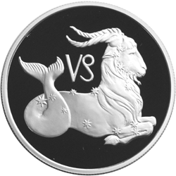
EGYPTIAN PETROGLYPH IDENTIFIED AS A CONSTELLATION – THE EL-HOSH CAPRICORN (GOAT-FISH):

The el-Hosh Capricorn petroglyph, Egypt. Image from msn.com.

A recent paper (2024) by Linda Evans and her team discuss a petroglyph with a combination of the apparent fore-quarters of a quadruped and the rear half being a fish tail, discovered at a rock art site in Upper Egypt. Their analysis led to conclusions that it represented the goat-fish symbol for the constellation Capricornus.

Close-up of the el-Hosh Capricorn petroglyph, Egypt. Image from phys.org.

“A new study by Dr. Linda Evans and her colleagues from Macquarie University, Australia, published in the Journal of Egyptian Archaeology, has recently identified what may be an Egyptian petroglyph depicting the zodiac sign Capricornus, a hybrid creature with the forequarters of a goat and the body of a fish. Zodiac symbols are completely unattested in Egyptian rock art, making this image the only known example. By studying the history of the zodiac sign, its introduction into Egypt, and its use, the researchers were able to determine the likely period of and possible reason for its creation.” (Oster 2024)

Enhanced image of the el-Hosh Capricorn petroglyph, Egypt. Image from phys.org.

Drawing of the petroglyph. Image from Evans et al., 2024.

At some point in prehistory hominins came up with a number of ideas concerning the night sky. One was that the stars made patterns that they believed that they could identify with beings, creatures, or implements. With this belief established it is not a long way to the assumption that these stellar creatures or beings influence life here on earth. “The ‘goat-fish’, a mythical creature incorporating the horned forequarters of a goat and the torso of a large fish, has long been known from the ancient Near East and Mediterranean regions. It first appeared in Mesopotamia, where it later represented the zodiac sign of Capricornus. There is also sporadic evidence of the sign in Egypt, beginning in the Graeco-Roman Period. Here we present an unusual petroglyph at the rock art site of el-Hosh in Upper Egypt (70 km north of Aswan, on the west bank of the Nile), which depicts a hybrid mammal and fish figure that we propose may also represent Capricornus.” (Evans et al. 2024) And, once we have accepted the proposition that what happens in the heavens influences life here on earth, then it is only natural to look for patterns or movements to try to analyze what they portend, and to develop rites and rituals to try to influence these portents.

The Sumerian god Enki. Illustration from mythology.net

Sandee Oster (2024) described the development of Capricornus as a symbol for a constellation. “The first occurrence of something resembling Capricornus occurred in Mesopotamia, where the Sumerian got Enki and the Akkadian equivalent Ea were usually depicted as bearded men with horned caps, wearing gowns. At the shoulders of these gowns, water streams filled with fish would spout. This later evolved into the first recognizable depiction of a goat-fish hybrid at the feet of the god on cylinder seals dating to ca. 2112-2004 BCE.” (Oster 2024) This cylinder seal was not illustrated.

Babylonian Capricorn on a boundary stone. (redrawn from Hinke 1907 fig. 36) Evans et al., 2024.

Greek Capricorn (sea goat). Illustration from Wikipedia.

According to Oster, the Greeks got the idea of the zodiac from the early Mesopotamian civilizations. “From Mesopotamia, the zodiacs and their associations eventually spread to Greece (5th century BCE) and from there to Rome (1st and 2nd century CE). By at least 300 BCE, zodiacs were known to Egypt and their earliest depictions could be found on zodiac ceilings in Egyptian Ptolemaic temples such as the temple Montu and Rattawy at Armant (c. 44-30 BCE). Later these zodiac symbols, including Capricornus, occurred in Roman-era temple ceilings, coffin lids, tombs, and even coins.” (Oster 2024)

Interestingly, I can find no mention of a capricornus or goat-fish hybrid therianthrope  anywhere online as being part of the Egyptian zodiac. Capricorn is one of the constellations in the Greek zodiac suggesting the possibility that this would have been introduced into Egypt by the Greeks or Romans

Later Egyptian (Greek period) Capricorn from the hypostyle hall, temple of Hathor, Dendera (traced from photograph), Evans et al. 2024.

Later Egyptian (Greek period) Capricorn from the Osiris chapel, temple of Hathor, Dendera (traced from photograph), Evans et al., 2024.

Linda Evans et al. (2024) came to the same conclusions when discussing the potential date of the petroglyph in question. “If a connection with Capricornus is accepted, a Graeco-Roman date for the petroglyph’s production may be possible. Furthermore, the creature’s outstretched tail possibly indicates a period earlier than the second century CE, when the Roman loop-tailed version of Capricornus became popular. It should be noted, however, that it has been proposed that Egyptian knowledge of the zodiac could have come directly from Mesopotamia, rather than via Hellenistic Greece.” (Evans et al. 2024)

Evans et al. discuss whether the possible origin of the symbol could be Mesopotamian or Graeco-Roman and note that if it was Mesopotamian the goat-fish could predate the Graeco-Roman Period. Their conclusion, however, is that it is more likely to have been created between the first century BCE and the end of the first century CE. One major clue that led them to this conclusion is the presence of Greek script carved on a nearby petroglyph panel.

NOTE: Some images in this posting were retrieved from the internet with a search for public domain photographs. If any of these images are not intended to be public domain, I apologize, and will happily provide the picture credits if the owner will contact me with them. For further information on these reports you should read the original reports at the sites listed below.

REFERENCES:

Evans, Linda, Fred Hardtke, and Wouter Claes, 2024, The Goat-Fish of El-Hosh: An Unusual Petroglyph Identified, The Journal of Egyptian Archaeology Online. Accessed online 20 November 2024.

Oster, Sandee, 2024, First ever goat-fish petroglyph reveals Egyptian  understanding of zodiac symbols, 19 November 2024, Phys.org. Accessed online 20 November 2024.

Saturday, December 7, 2024

A DONKEY IMAGE FOUND AT KARAHAN TEPE:

Excavation at Karahan Tepe, Turkey. Image from easternturkeytour.org.

A charming petroglyph of a running wild donkey has been discovered at the site of Karahan Tepe. "Karahan Tepe is an archaeological site in (the) Sanliurfa Province in Turkey. The site is close to Gobekli Tepe and archaeologists have also uncovered T-shaped stelae there and believe that the sites are related. According to Daily Sabah, 'The excavations have uncovered 250 obelisks featuring animal figurines' as of 2020. Additiionally, the site may be the earliest known human village, predating the construction of Gobekli Tepe, dating to between 9,000 - 11,000 BC." (Wikipedia) The "Daily Sabah" is a Turkish newspaper that is published in the English language. Other publications give the total number of obelisks as 266. Given the stylistic resemblances between Gobekli Tepe and Karahan Tepe this relationship would seem to be obvious.

Running wild donkey figure, Karahan Tepe, Turkey. Image from  anatolianarchaeologyy.net.

“The ongoing excavations at Karahan Tepe, led by Professor Dr. Necmi Karul, have revealed a remarkable new find: a depiction of a running wild donkey carved onto a stone laid on the floor of an ancient structure. This depiction, approximately 20 centimeters in length, is notable not only for its size but also for its dynamic portrayal, which reflects the artistic skills of Neolithic people. ‘The donkey figure found is a figure about 20 centimeters long, placed right next to the grinding stone,’ Dr. Karul told the correspondent. Rather than its dimensions, the fact that it is mobile and depicted in proportion to the stone on which it is carved is again an indication of the skill of the artists of this period.” (Radley 2024) I would not call a paving stone set in the floor mobile, but this is merely a detail.

Running wild donkey figure, Karahan Tepe, Turkey. Image from  anatolianarchaeologyy.net.

“The period of domestication and distribution of the donkey (Equus asinus) in Turkey occurred around 5000 to 7000 years ago. They are thought to have their origins from the Nubian (Equus africanus africanus) and Somalian (E. a. somaliensis) ass, both of which are subspecies of the African wild ass. The African wild ass lived in the deserts and other arid areas of the Horn of Africa, in Eritrea, Ethiopia and Somalia. However, it formerly had a wider range that extended into Egypt.” (Milligan 2024) This timeline does not seem to fit the estimated dates of occupation for Karahan Tepe (ca. 11,000 – 9,000 BCE) unless it was occupied for two thousand years or more, which is not backed up by estimations for the occupation dates there.

Running wild donkey figure, Karahan Tepe, Turkey. Image from  anatolianarchaeologyy.net.

 “According to Dr. Karul, the wild donkey motif is the first of its kind discovered at Karahan Tepe, adding a new dimension to our understanding of animal iconography and the relationship between humans and their environment during this perion. He explained that the animals depicted in the iconography of the era generally fall into two categories, those with an erie, imposing presence, often seen on obelisks, and more commonly consumed animals, such as birds, gazelles, and wild donkeys. The latter were animals that people lived with, consumed, and were surrounded by, compared to the more fearsome creatures. ‘The depiction of the wild donkey in motion, carved onto the base of a grinding stone is particularly notable as it is the first time we have encountered such a moving wild donkey motif.’” (Radley 2024)

Closeup of running wild donkey figure, Karahan Tepe, Turkey. Image from anatolianarchaeologyy.net.

Once again we seem to have discrepancy because pictures very clearly show the stone that the donkey is carved onto next to a grinding stone, not on its base. These discrepancies of date and location are mere details (errors of reporting) however, compared to the very early and wonderful depiction itself which we can confirm in the photographs.

NOTE: It is even possible that the small, factual discrepancies between reports could have resulted from differing interpretations during translation from an original report in Turkish.

REFERENCES:

Milligan, Mark, 2024, Donkey depiction discovered at Karahan Tepe, 22 August 2024, Heritage Daily online, https://www.heritagedaily.com. Accessed online 17 October 2024.

Radley, Dario, 2024, Running wild donkey figure discovered at Karahantepe, 31 August 2024, Archaeology magazine online, https://archaeologymag.com. Accessed online 17 October 2024.

Wikipedia, Karahan Tepe, https://en.wikipedia.org/wiki/Karahan_Tepe. Accessed online 23 October 2024.

Saturday, July 6, 2024

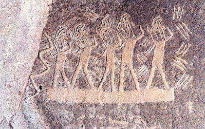
MUSIC AND DANCE IN ROCK ART - THE TORO MUERTO PETROGLYPHS:

Dancers from Toro Muerto, Peru. Image from Toro Muerto Archeological Research Project Archives.

A huge number of petroglyphs can be found at a site called Toro Muerto in Peru. Although Toro Muerto is one of the largest rock art sites in Peru it has not been extensively studied. Recently a team of archeologists has published studies of the rock art of Toro Muerto. Andrzej Rozwadowski, Liz Gonzales Ruiz and Janus Z. Woloszyn published a paper in 2019 covering the rock art of Toro Muerto in general, and then in 2024 Rozwadowski and Woloszyn followed that with an analysis of the themes on some of the boulders as dancers and representations of the music accompanying the dancers.

Toro Muerto petroglyph boulder. Photograph A. Rozwadowski.

Dancers with zig-zag lines. Toro Muerto petroglyph boulder.  Drawing Polish-Peruvian research team.

“Toro Muerto, meaning ‘dead bull’ in Spanish, is a significant rock art complex located in southern Peru, nestled within a desert gorge near the Majes River Valley. Encompassing and expansive area of approximately 10 square kilometers (3.86 sq mi), this site holds around 2,600 volcanic boulders, each adorned with ancient petroglyphs. These petroglyphs vary in size and complexity ranging from small stones featuring single motifs to massive boulders adorned with intricate arrays of multiple images.” (Pandey 2024)

Another Toro Muerto petroglyph boulder with dancers and zig-zag lines. Photograph A. Rozwadowski. Drawing Polish-Peruvian research team.

“Unique to the Toro Muerto petroglyphs are the drawings of the so-called "danzantes" or dancers. A danzante is a schematic drawing of a human figure, usually 20-30 cm high, often depicted in a dynamic pose with one arm raised and the other lowered, legs slightly apart (sometimes bent at the knees), and the head presented in profile or facing forward. While the geometric patterns, lines, and zigzags accompanying the danzantes were initially thought to represent snakes or lightning bolts, Polish scientists who analyzed these 2,000-year-old rock carvings have proposed a different theory.” (Waters 2024)  On 15 April 2012, I wrote a column on RockArtBlog about Dancing Figures in rock art (Faris 2012). At that time I had not yet seen any of these marvelous petroglyphs at Toro Muerto.

Another Toro Muerto petroglyph boulder with dancer and zig-zag lines. Photograph A. Rozwadowski.

“A new study published in the Cambridge Archaeological Journal proposes a novel interpretation: the abstract geometric shapes adorning the volcanic boulders might be representations of ancient songs potentially linked to shamanic rituals involving hallucinogenic plants.” (Radley 2024) I would think that this implies a strange twist on the neuropsychological model, stating that the petroglyphs represent visions seen accompanying music during hallucinations.

“It is worth noting that Antonio Núñez, Cuban ambassador to Peru and one of the most important early researchers of Toro Muerto, suggested that some of the geometric motifs he observed at this site (zigzags, straight lines, points) represent musical or dance signs(signos musicales o danzarios), or sound communication.” (Rozwadowski and Woloszyn 2024)

Rudolph Laban. Image from Wikipedia.

Laban Dance Notation System chart. Internet image, public domain.

So, the idea that the lines, zigzags, etc., represented music that the anthropomorphs are dancing to has been considered a possibility since these petroglyphs were first studied. When I first saw the pictures I was struck by their resemblance to Laban diagrams invented to record dance movements. This is officially known as “Laban Movement Analysis." “LMA is largely taken from Rudolph Laban’s ‘The Mastery of Movement,’ first published in 1950. A choreographer and dance theorist hailing from Austria-Hungary, Laban was a pioneer of modern dance as we know it today. - - He also created intricate taxonomies for understanding human movement, such as labonotation, a theory of dance notation and analysis.” (Woltmann 2022) Now, I am not suggesting that these petroglyphs that accompany the ‘dancers’ are actually something like a Laban diagram, but I find the resemblance to be striking, a fascinating coincidence.

NOTE: Some images in this posting were retrieved from the internet with a search for public domain photographs. If any of these images are not intended to be public domain, I apologize, and will happily provide the picture credits if the owner will contact me with them. For further information on these reports you should read the original reports at the sites listed below.


REFERENCES:

Faris, Peter, 2012, Dancing Figures, 15 April 2012, https://rockartblog.blogspot.com/search/label/Dancing%20figures.

Pandey, Sahir, 2024, Are Toro Muerto’s Petroglyphs in Peru Hallucinogenic Visions in Stone, 10 April 2024, https://www.ancient-origins.net. Accessed online 25 May 2024.

Radley, Dario, 2024, Geometric petroglyphs in Peru may represent ancient songs from shamanic rituals, 8 April 2024, https://archaeologymag.com. Accessed online 9 April 2024.

Rozwadowski, Andrzej, and Janus Z. Woloszyn, 2024, Dances with Zigzags in Toro Muerto, Peru: Geometric Petroglyphs as (Possible) Embodiments of Songs, pp. 1-21, published online by the Cambridge Archaeological Journal on behalf of the McDonald Institute for Archaeological Research, Cambridge, UK. Accessed online 13 May 2024.

Waters, Connie, 2024, Ancient Petroglyphs In Toro Muerto Are Not What We Thought – Archaeologists Say, 24 May 2024, https://ancientpages.com. Accessed online 24 May 2024.

Woloszyn, Janus Z., Liz Gonzales Ruiz, and Andrzej Rozwadowski, 2019, The Petroglyphs of Toro Muerto: new documentation and discoveries at the largest South American rock art complex, pp. 1-8, Antiquity, Vol. 93, No. 372. https://doi.org/10.15184/aqy.2019.200. Accessed online 14 May 2024.

Woltmann, Suzy, 2022, Laban Movement Analysis: An Introduction for Actors, 18 July 2022, https://backstage.com/magazine/article/laban-movement-analysis-guide-50428. Accessed online 26 June 2024.

Saturday, May 11, 2024

BRAZILIAN PETROGLYPHS RECORDED NEAR DINOSAUR TRACKS:


Caatinga landscape. Illustration from Wikipedia.

Two of my favorite things in the natural world are rock art (which readers of RockArtBlog will have recognized by now), and fossilized dinosaur tracks. Any report of finding them in conjunction in the same site is positively exciting, and now we have a report of just such an occurrence in Brazil.

Aerial view of Outcrop 1. Illustration Troiana et al., 2024.

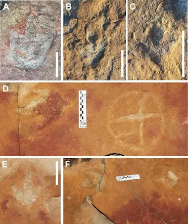
Leonardo Troiano wrote in the 2024 paper describing this discovery: “The Serrote do Letreiro Site, found on the northwest periphery of the Sousa Basin, Brazil, presents a remarkable convergence of paleontological and archaeological elements. It is constituted of subhorizontal "lajeiros", or rock outcrops, intermingled with endemic Caatinga vegetation. The three prominent outcrops feature fossilized footprints of theropod, sauropod, and iguanodontian dinosaurs from the Early Cretaceous Period. Adjacent to these dinosaur tracks, indigenous petroglyphs adorn the surface. The petroglyphs, mainly characterized by circular motifs, maintain a striking resemblance to other petroglyphs found in the states of Paraíba and Rio Grande do Norte.” (Troiano et al. 2024) Caatinga is a type of semi-arid tropical vegetation, and an ecoregion characterized by this vegetation in interior northeastern Brazil (Wikipedia). Rock outcroppings in this forest have been found to contain not only three different types of dinosaur footprints, but petroglyphs as well, and it is herein postulated that the dinosaur tracks themselves were one reason for the subsequent placement of petroglyphs on those rock faces. 

Outcrop 1, dinosaur tracks (enhanced) and petroglyphs (dotted circles). Illustration from Scientific Reports, 2024.

"The lithological support on which petroglyphs and dinosaur tracks are located are sub-horizontal sandstone and comglomerate sandstone strata situated on a small hill, known as 'Serrote'. There is evident displacement of sizable surface portions due to rainwater runoff on the inclined support. The makers' preference for such type of sandstone is commonly observed in the Northeast region of Brazil, where many of these rock formations were used as support for petroglyphs. Additionally, the site in question is positioned near a water source, specifically a small lake and a temporary stream, which is likewise a recurring factor is similar sites in the region. The process of creating the petroglyphs involved the use of mixed techniques. The petroglyphs were first carved by scraping with light contact between an abrasive instrument and the rock surface. Irregularities are observed on the inner endes of the rock grooves, a result of fast movement, causing friction between the instrument and the surface. Many of the petroglyphs underwest subsequent pecking so that the ingraving line was refined by a series of continuous impacts using a sharp instrument. This complementary process resulted in small and repeated concavities of greater depth than those observed in petroglyphs made only through scraping. The preference in some instances for the scraping technique often produces shallow petroglyphs, with renders them more vulnerable to erosion, resulting in the current low visibility and legibility of many petroglyphs." (Troiano et al. 2024) Note, they report that some of the petroglyphs had been renewed or repecked. When I carefully read the authors' description of how these petroglyphs were produced I found myself in disagreement. Carving stone with "scraping with light contact" and then "fast movement, causing friction" is not a practical way to remove stone. One either grinds or pecks the surface with a harder stone. The comment about "subsequent pecking", however appears to be right on. No real blame though, kunless a person has actually worked stone they can be forgiven for not totally understanding the process.

Outcrop 1, Dinosaur footprints and petroglyphs. Illustration Troiana et al., Figure 4, 2024.

 “Concerning the morphology of the identified petroglyphs, the presence of tetrapartite or pentapartite circumferences stands out. Nevertheless, there are notable exceptions to this trend, including engravings comprised of rectangular grid structures and others resembling stars. Despite the profusion of identified petroglyphs, no overlap was observed between these inscriptions and the fossilized footprints. In none of the cases was it found that the creation of a petroglyph resulted in damage to the existing footprints, suggesting thoughtfulness by the makers. In some cases, there is an extreme proximity between petroglyphs and footprints, with some occurring immediately adjacent to the fossilized tracks. This only highlights and establishes a more profound relationship between the archaeological and paleontological records. Concerning the graphic identity, or the "set of characteristics that allow attributing a set of graphisms to a particular social authorship, it was determined that the Serrote do Letreiro site belongs to a broad set of archaeological rock art sites in the Brazilian Northeast region that present an identical repertoire of motifs, either pure or abstract, and of similar or identical execution techniques. In the first rock outcrop, located further north, it is possible to identify a higher concentration of dinosaur tracks. Reports from previous visitors to the site from the past twenty years, as well as statements from residents, indicate that until not long ago, there were a minimum of thirty such petroglyphs that were discernible on outcrop 1. The legible petroglyphs found on this outcrop consist predominantly of circles internally divided by lines and are positioned close to the footprints, in some cases as close as a distance of 10 cm.” (Troiano et al. 2024) It would appear to be important that “no overlap was observed between these inscriptions and the fossilized footprints.” This implies to me that the makers of these images carefully avoided overlapping any of the dinosaur footprints, suggesting that they were recognized as being of import.

        
Outcrop 1, Dinosaur footprints and petroglyphs. Illustration Troiana et al., Figure 5, 2024.

No culture leaves basic questions unanswered. I have written elsewhere that one thing that the indigenous inhabitants of the Americas knew well was animal tracks. So many of the tribes depended upon hunting for sustenance would have made reading tracks a priority. Finding these tracks in stone would have presented a conundrum to them – animal tracks in stone that they did not recognize. Something made those tracks, and they did not fit any of the contemporary animals that they knew. I have speculated that this would be one of the factors that led to beliefs in supernatural creatures that could have made the tracks, and once the idea of supernatural is involved such a site probably acquires ritual and spiritual importance. In the past I have referred to this as Native American Paleontology. They had their answers, just not the same ones that we had come up with. This spiritual importance led to the production of the petroglyphs, carefully avoiding the tracks.

Outcrop 3, Dinosaur footprints and petroglyphs. Illustration Troiana et al., Figure 7, 2024.

Here, the authors refer to the eloquent writings of Adrienne Mayor. “Overall, the systematic examination of interactions between humans and the fossil record, such as fossil discoveries in the pre-Columbian era, is a relatively recent scholarly endeavor. Adrienne Mayor played an important role in highlighting the evolution of this research in two significant publications: "The First Fossil Hunters: Paleontology in Greek and Roman Times" (2000) and "Fossil Legends of the First Americans" (2013). As early as 1935, there was recognition that the discipline of paleontology is indebted to Native Americans, considering their relevant discoveries, as described by Edward M. Kindle in his notes in the Journal of Paleontology. Despite this, some prominent paleontologists, such as G. Gaylord Simpson, held the opposite view, exemplifying the paradigm that prevailed for most of that time. According to him, pre-Columbian fossil findings were occasional events and are not to be considered in the history of paleontology. Furthermore, he claimed that Native American reports were untrustworthy, being of little ethnological and no paleontological value. This hegemonic conception disregarded native contributions, arguing that fossil discoveries made by indigenous people were the mere result of chance finds, devoid of any scientific continuity (see page 26 in Mayor). Nonetheless, today, it is indisputable that Native American thought represents a distinct and valuable form of scientific reflection and inquiry. This knowledge, developed over generations, is often referred to as “Native Science”. It is important to highlight that, despite the differences between the Western Scientific Method and Native Science or Traditional Knowledge, both represent equally valid efforts to grasp, describe, and understand the reality that surrounds humans. The integration of Native science knowledge provides a valuable opportunity for academic exchange while at the same time contributing to the empowerment and inclusion of Native American voices in this sphere.” (Troiano et al. 2024)


Therapod track. Illustration Troiana et al., Figure 13A, 2024.

Petroglyph resembling a therapod track. Illustration Troiana et al., Figure 13C, 2024.

These last few lines once again provide a well presented view of what I have called Native American Paleontology. Our science might not have agreed with their conclusions, but their conclusions were valid for their world view and belief systems, and worked for them.

NOTE: Previous RockArtBlog columns on the concurrence of rock art and dinosaur tracks can be accessed through “dinosaur tracks” in the cloud index at the bottom of this column. For much more thorough descriptions of the three sites read the original paper by Troiano et al. (2024).

PRIMARY REFERENCE:

Troiano, Leonardo P., Heloísa B. dos Santos, Tito Aureliano, Aline M. Ghilardi, 2024, A remarkable assemblage of petroglyphs and Dinosaur footprints in Northeast Brazil, Nature/Scientific Reports 14:6528, https://doi.org/10.1038/s41598-024-56479-3. Accessed 22 March 2024.

SECONDARY REFERENCES:

Mayor, Adrienne, 2000, The First Fossil Hunters: Paleontology in Greek and Roman Times, Princeton University Press.

Mayor, Adrienne, 2013, Fossil Legends of the First Americans. Princeton University Press.