Showing posts with label australia. Show all posts

Saturday, September 5, 2026

DAMAGE TO ROCK ART FROM POWER PLANT POLLUTION EMISSIONS:

Murujuga, on the Burrup Peninsula and Dampier Archipelago in the Pilbara region of Western Australia. Photograph from newsartnet.com.

From 2020 to 2026 a study was conducted at a location known as Murujuga, on the Burrup Peninsula and Dampier Archipelago in the Pilbara region of Western Australia. This fascinating study was an attempt to discern what, if any, damage to rock art was inflicted by the air pollution emitted from power plants and industrial enterprises.

Petroglyph at Murujuga, on the Burrup Peninsula and Dampier Archipelago in the Pilbara region of Western Australia. Photograph from newsartnet.com.

Amy Stevens (2026) has written about the area and the importance of the abundant rock art found there, frequently citing K. A. Evans (2026). “Murujuga is a sacred cultural landscape of land and sea Country across the Burrup Peninsula and Dampier Archipelago, in Western Australia’s Pilbara region. It contains an estimated 1 million to 2 million petroglyphs, or rock engravings, that tell the story of the relationship between Ngarda-Ngarli Traditional Owners and this landscape over at least 50,000 years. These petroglyphs hold deep meaning for Ngarda-Ngarli, embodying cultural, spiritual, ancestral and environmental knowledge.” (Stevens 2026)

Petroglyph at Murujuga, on the Burrup Peninsula and Dampier Archipelago in the Pilbara region of Western Australia. 1970 Photograph from newsartnet.com (red arrows show details).

“In July 2025, the Murujuga Cultural Landscape was added to the UNESCO World Heritage List in recognition of its outstanding cultural and spiritual significance. This brought renewed attention to Murujuga, “commodities such as liquefied natural gas (LNG). Concerns have been raised that industrial pollution is degrading the rock art.” (Stevens 2026) As it is a site in the UNESCO World Heritage List, there is an international recognition of its importance to all people, and degradation of the rock art is then a concert to all people.

Same petroglyph at Murujuga, on the Burrup Peninsula and Dampier Archipelago in the Pilbara region of Western Australia. 1970 Photograph from newsartnet.com showing missing details.

Indeed, this has been a concern for over a decade. A 2017 paper by John Black studied the color changes that the pollution might cause in the patina of the rock art panels, and did conclude that there was destruction beginning to show. “The art is under threat due to high concentration sof acidic and nitrate-rich pollution from nearby industrial complexes. Maintenance of the outer, rock or desert varnish, layer of therocks is essential for preservation of the art. An increase in acidity of rock surfaces through acid rain and organic acids from nitrate-stimulated microbial growth may alter the mineral composition, integrity and color of the rock varnish. This paper describes analyses of distilled water washings from rocks on Burrup Peninsula compared with rocks collected prior to industrialization. Acidity of rock surfaces has increased from near neutral to a pH just above 4. The increasing acidity has been associated with a logarithmic increase in solubilization of manganese (Mn) and iron (Fe) compounds from the rock surfaces. A theoretical evaluation using electrochemical equilibrium principles confirms that increasing acidity will increase the solubilization of Mn and Fe compounds. Removal of darker Mn and Fe mixed M(II)/M(III) compounds from the outer, rock varnish layer and the relative increase in ferrous oxide and illite/kaolin compounds will result in the rock surface layers becoming thinner, lighter, redder and more white/yellow over time. The impact on engraved surfaces would be expected to be greater because the rock varnish is thinner than on the non-engraved surface rock. Pollution from industry on Burrup Peninsula is likely to destroy the rock art over time.” (Black et al 2017) In other words, Black et al found that aerial pollution was degrading the patina on the rock surfaces, especially within the petroglyphs themselves.

Petroglyph at Murujuga, on the Burrup Peninsula and Dampier Archipelago in the Pilbara region of Western Australia. 1974 Photograph from newsartnet.co.

Stevens (2026) reported on the third annual report of this monitoring program. In her article K. A. Evans stated “today we released the third annual peer-reviewed report of the Murujuga Rock Art Monitoring Program (MRAMP). This government-funded research effort doesn’t resolve every question – understanding a system as complex as Murujuga takes time. The research is undertaken by a team of more than 30 multidisciplinary researchers, and independently peer reviewed by a range of international experts. It is solely written by the researchers.” (Stevens 2026)

Same petroglyph at Murujuga, on the Burrup Peninsula and Dampier Archipelago in the Pilbara region of Western Australia. 2021 Photograph from newsartnet.com (red arrows show damage to the stone).

Stevens (2026) quoted from Evans report that “Earlier monitoring pointed to nitrogen dioxide, the most abundant air pollutant gas at Murujuga, as a possible cause. But our data at the time couldn’t clearly separate its effects from other air-borne pollutants, particularly sulfur dioxide.” (Stevens 2026)

Petroglyph at Murujuga, on the Burrup Peninsula and Dampier Archipelago in the Pilbara region of Western Australia. 1988 Photograph from newsartnet.co.

Evans (2026) stated “This year’s results change that and the acid rain it can produce, as the most relevant factor. The chemistry behind this is well understood: sulfur dioxide reacts in the atmosphere or on the rock surface to form sulfuric acid. This can dissolve the manganese and iron oxide minerals that give the rock varnish its dark color, to create porosity. Several lines of evidence – atmospheric chemistry, rainfall pH and laboratory testing – now point to historic levels of sulphur dioxide from a range of industry and shipping.” (Evans 2026) Known as acid rain this will degrade the patina as well as the rock surface.

Same petroglyph at Murujuga, on the Burrup Peninsula and Dampier Archipelago in the Pilbara region of Western Australia. 2021 Photograph from newsartnet.co.

“Rock, rainfall, and dry deposition pH values argue against present-day acidification of rock surfaces and historically high rates of patina dissolution. However, the elevated porosity values proximal to heavy industry require explanation. Any such explanation must be placed in the context of this ancient landscape. The rocks of Murujuga weathered sub-aerially for thousands to tens of thousands or even hundreds of thousands of years, prior to the introduction of heavy industry from the 1960s onwards. As heavy industry evolved, the fluxes and composition of emitted gases changed. This extended history complicates attribution of the elevated porosity to any specific time or emissions source. Porosity would have formed naturally over the weathering history of the rock. However, elevated porosity within the weathered rind is observed proximal to Dampier, within a region spatially coincident with current elevated concentrations of NO2. This association suggests a link between emissions and the elevated porosity. Both NOx, which include NO2, and SOx which include SO2, are considered reactive gases, which means that they react in the atmosphere to form nitric and sulfuric acids, which can increase the rate of rock weathering.” (Evans 2026)

Petroglyph at Murujuga, on the Burrup Peninsula and Dampier Archipelago in the Pilbara region of Western Australia.  Photograph from newsartnet.com.

“Damage to landscapes such as Murujuga rarely have a single cause. We’re tracking how many factors interact, sometimes over decades. The fourth and final year of this research will focus on the interplay of air quality, rock surfaces and microbial communities. We will also complete the environmental criteria to protect Murujuga in the long term, with a focus on ammonia and ozone, in addition to sulphur dioxide and nitrogen dioxide. However, ongoing monitoring will continue to ensure the protection of the rock art.” (Stevens 2026) This damage has accumulated over time, and perhaps will hopefully be prevented in the future. This is, however, not the only site by any means where rock art has been damaged by industrial pollution. Indeed, using the findings of both the 2017 study (Black et al.) and the 2026 study (Evans et al.) these processes are constantly at work at many rock art sites, if not all.


Hayden coal generating station, Hayden, Colorado. Photograph by cpr.com.

One site that I know well, here in Colorado, is not far from the Hayden Power Plant in Hayden, Colorado. This is a 465 megawatt coal generating station operated by Xcel Energy Company. This is quite near the Hayden pictograph site which is found along Highway 40. As the photographs show, the rock face here is extremely degraded.

Pictograph panel near Hayden power station showing degraded condition. Photograph Peter Faris, 1982.

Equestrian figure from the left side of the pictograph panel near Hayden power station showing degraded condition. Photograph Peter Faris, 1982.

This damage is not just from the shotgun pellets scattered all over the equestrian on the left (seen as faint white spots). The coal plant emissions cannot be doing this rock art panel any good. Wouldn’t it be a lovely surprise to find something happening to rock art that is good for its preservations?

REFERENCE:

Black, John L. et al., 2017, Theoretical effects of industrial emissions on color change at rock art sites on the Burrup Peninsula, Western Australia, Journal of Archaeological Science: Reports 12, 457-462. Accessed online on 29 August 2026.

Evans, K. A. et al., 2026, Impacts of industrial emissions on rock art at Murujuga, Western Australia, Scientific Reports (2026) 16:13805. Accessed online on 29 August 2026.

Stevens, Amy, 2026, Historic sulfur emissions the likely cause of damage to Murujuga rock art: new research, 25 August 2026, https://theconversation.com. Accessed online on 26 August 2026.


Saturday, May 30, 2026

THYLACINE AND TASMANIAN DEVIL PAINTINGS IN NORTHERN AUSTRALIA:

Thylacene cynocephalus (Tasmanian tiger). Internet image, public domain.

Sarcophilus harrisii (Tasmanian devil). Image from Wikipedia.

Most of us probably know of the Tasmanian Devil as the Looney Tunes cartoon character who appeared in 1954. Disappearing in 1964, he reappeared in the 1990s and again became popular. (Wikipedia) The thylacine (Tasmanian tiger) may be the most popular target of cryptozoologists trying to prove rather or not they are completely extinct. It is also one of the most mentioned targets for the biological concept of de-extinction, recreating an extinct animal by using DNA from museum collections. Tasmanian devils are not yet extinct on the island of Tasmania, but are threatened by their bizarre cancerous facial tumors that affect most of the population.

Thylacines, Injalak Hill, Northern Territory, Australia. Image from Craig Banggar.

Paul Tacon wrote a concise history of the discovery and early classification of these creatures. “The Tasmanian devil (Sarcophilus harrisii) and the Tasmanian tiger (Thylacinus cynocephalus), also known as thylacine, were first described scientifically in 1808 by George Prideaux Harris, the then Deputy Surveyor of Van Diemen’s Land. ‘the species was originally given the scientific name Didelphis cynocephali (dog-headed opossum), alongside the Tasmanian devil (Didelphis ursine) or bear opossum’ by Harris. Later in the 1800s, there were various taxonomic name changes to both species, resulting in the current classifications and the Tasmanian devil being named after Harris. To date, few skeletal remains of devils or thylacines have been found in Arnhem Land (Northern Territory, Australia), but part of a Tasmanian devil mandible was recovered from an excavation at the Padypadiy rock shelter), the East Alligator River in a deposit dated to 3120 ± 100 BP. Nearby, at the Madjedbebe rock shelter – recovered a thylacine maxillary fragment painted with red ocher dated to ‘2.7 – 3.9 calibrated kyr BP’.” (Tacon et al. 2026) So, when Europeans reached Australia, these animals were both extinct on the mainland, but remembered in the myths and legends of the aborigines.

Painting of a Tasmanian Devil in a cave-like Awunbarna site, northwest Arnhem Land. DStretch version (yre). Image from Paul S. C. Tacon et al, Fig. 4.

Rock art depictions suggest thylacines were more widespread and more culturally important across mainland Australia than Tasmanian devils as only 25 Tasmanian devil images have been documented, including the two described above, versus over 160 thylacine depictions. Thylacines may also have survived much longer in pockets of western Arnhem Land, the Kimberley and elsewhere than Tasmanian devils after the arrival of the dingo. (Tacon et al. 2026)

Western Arnhem Land has the most detailed oral history about thylacines from anywhere in Australia and stories about the creature continue to be told by some people today. In western Arnhem Land oral history thylacines are associated with Rainbow Serpents and often are described as the Rainbow Serpent's pets or dogs, sometimes in pairs and swimming. Three of the Awunbarna sites discussed above have pairs of thylacines and we have documented 29 paintings of Rainbow Serpents at Awunbarna. One of the Awunbarna Rainbow Serpents, less than 1000 years of age given the style and preservation, has three small thylacine-like creatures painted over part of its tail that are fresh-looking and do not appear to be very old. (Tacon et al. 2026) As to this last example we must remember that Australian First Nations tradition includes individuals who are responsible for pictograph sites and are supposed to refresh or repaint them whenever they need it.

Awnbarna Maliwawa style Thylacines next to Malinwawa human figures. DStretch (ids). Image by Joakim Goldhahn, from Tacon et al, Fig. 8.

Indigenous peoples also told stories of how thylacines hunted kangaroos. Contemporary western Arnhem Land artists are inspired by these and related stories as well as rock art depictions, so that occasionally paintings of thylacines are made on bark, paper and canvas. But contemporary paintings of Tasmanian devils or other extinct animals are not made despite lots of mythological creatures with animal, human-animal or human-like forms made by western Arnhem Land artists today and in the past 100 years. (Tacon et al. 2026) Many more illustrations are in the 2026 report by Tacon et al, listed below.

As I said above, thylacines, along with mammoths, are perhaps the most popular targets for de-extinction using DNA from museum specimens. On the island of Tasmania cryptozoologists are still searching for specimens of the Tasmanian tiger, and some claim they have seen it but no solid proof has been presented. It is, however, a fascinating subject and I wish them all luck.

NOTE: Some images in this column were retrieved from the internet with a search for public domain photographs. If any of these images are not intended to be public domain, I apologize, and will happily provide the picture credits if the owner will contact me with them. For further information on these reports you should read the original reports at the sites listed below.


REFERENCES:

Tacon, Paul S. C. et al., 2026, The Devil is in the Detail: Tasmanian Devil and Tasmanian Tiger Paintings from Awunbarna and Injalak Hill, Northern Territory, Australia, 30 March 2026, doi.org/10.1002/arco.70024. Accessed online 12 April 2026.

Morwood, M. J., 2002, Visions from the past, the archaeology of Australian Aboriginal Art, with illustrations by D. R. Hobbs, Smithsonian Institution Press, Washington D. C., Fig. 620, p. 170.

Wikipedia, 2026, Tasmanian Devil, https://en.wikipedia.org/wiki/Tasmanian_devil. Accessed online 29 April 2026.

Saturday, January 24, 2026

TRAINING AI TO DETERMINE THE GENDER OF THE MAKERS OF FINGER FLUTING ON CAVE WALLS:

Finger fluting at Gargas Cave, France. Image from Clottes, 2002.

We are all probably aware of the existance finger fluting in caves, it is found all over the world, but it has always been somewhat peripheral to the subject of cave art itself. It is, however, purposeful markings made by people on the cave walls so it needs to be covered in any consideration of cave art. Various examples have been attributed to Neandertals, as well as Homo sapiens men, women and children. Now, a team in Australia is using artificial intelligence to try to clarify the makers of these marks.

“Flutings have the potential to reveal information about age, sex, height, handedness and idiosyncratic markmaking choices among unique individuals who form part of larger communities of practice. However, previous methods for making any determination about the individual artist from finger flutings have been shown to be unreliable4. Accordingly, we propose a novel digital archaeology approach to begin understanding this enigmatic form of rock art by leveraging machine learning (ML) as a tool for uncovering patterns from two datasets, one tactile and one virtual, collected from a modern population. We aimed to determine whether ML can reveal subtle differences in the sex of the artist based on their finger-fluted images.” (Jalandoni et al. 2025:1) In other words they will attempt to have machine learning programs learn to distinguish information like gender and age by analyzing finger fluting created by volunteers. If successful, this could then be applied to finger fluting in cave walls to learn more about the persons who originally created the marks.

Finger fluting attributed to Neandertals, Noire Valley, France. Image from Jean Claude Marquet.

“Experiments were conducted - both with adult participants in a tactile setup and using VR headsets in a custom-built program – to explore whether image-recognition methods could learn enough from finger fluting images made by modern people to identify the sex of the person who created them.” (Lock and Egan 2025:1) The team had participants actually make finger flutings in clay as well as virtually while being videotaped. “Two controlled experiments with 96 adult participants were conducted with each person creating nine flutings twice: once on a moonmilk clay substitute developed to mimic the look and feel of cave surfaces and once in virtual reality (VR) using Meta Quest 3. Images were taken of all the flutings, which were then curated and two common image-recognition models were trained on them. (Lock and Egan 2025:1-2)

Disappointingly, the tests did not produce reliable results. “The VR images did not yield reliable sex classification; even when accuracy looked acceptable in places, overall discrimination and balance were weak. But the tactile images performed much better. ‘Under one training condition, models reached about 84% accuracy, and one model achieved a relatively strong discrimination score.’ Dr. Tuxworth said. However, the models did learn patterns specific to the dataset; for example, subtle artifacts of the setup, rather than robust features of fluting that would hold elsewhere, which meant there was more work to be done.” (Lock and Egan 2025:1-2) Doctor Gervase Tuxworth is one of the experimental team that conducted this study. His statement suggests that the test results were highly variable.

Paleolithic finger fluting from Rouffignac Cave, France. Online image, public domain.

“Overall, the deep learning models achieved high accuracy during training, with AUC values exceeding 0.85 for certain tactile image conditions. These results suggest that the models effectively learned patterns within the tactile dataset and demonstrated strong discrimination between male and female-generated finger fluting images. However, the relatively lower AUC values for virtual images, coupled with their unstable test accuracy, indicate that they do not provide sufficiently distinct features for reliable sex classification. This discrepancy highlights the greater robustness of tactile images over virtual images in capturing relevant classification features. Despite the promising performance on tactile images, deep learning models exhibited a pronounced disparity between training and test performance. While training accuracy consistently increased, reaching near-perfect levels in the later epochs, test accuracy remained unstable and showed no substantial improvement over time. This pattern indicates overfitting, where the models effectively learn dataset-specific features but fail to generalize to unseen test data.” (Jalandoni et al. 2025:10) I find the previous paragraph somewhat confusing. It states “accuracy consistently increased, reaching near-perfect levels” and “accuracy remained unstable and showed no substantial improvement” in two contiguous sentences. In any case, the team did not get reliable results.

Finger fluting made by children, Rouffignac Cave, France. Online image, public domain.

There are a number of possible sources of inaccuracy in the test results.“The instability in test accuracy further suggests that the models struggle to extract robust and generalizable patterns from the finger fluting images, ultimately limiting their reliability for sex classification. A possible contributing factor to this challenge could be individual variation in hand size and fluting characteristics. For example, some females may have larger hands and exhibit stronger fluting patterns resembling those of males, while some males may have smaller hands and display lighter, less pronounced fluting strength. This variability could confuse the model, making it difficult to accurately differentiate between sexes and ultimately hindering its performance on the test set. These results underscore the critical need to increase the dataset size to alleviate overfitting and improve the model’s generalizability. Moreover, the inherent variability in finger fluting images may impose fundamental limitations on the feasibility of using deep learning for sex classification, suggesting that alternative approaches or additional contextual data may be necessary to enhance classification accuracy. The limited success of the tactile data in sex prediction underscores the importance of material-based approaches in understanding finger flutings. While the VR data failed to provide useful results, it opens up new and exciting possibilities for exploring the dynamic aspects of fluting and artistic intent in the future. While a modest achievement, this study highlights the potential of ML to enhance traditional archaeological methods”. (Jalandoni et al. 2025:10) Not every try is guaranteed success.

Koonalda Cave finger flutings, Australia. Photograph Robert Bednarik, 1979.

So, this test did not manage to display reliable accuracy, too many variables in the creation of finger fluting seemingly overwhelmed the software. Also, the experiment apparently did not include children, and it is thought that much finger fluting, at least in European cave contexts, was created by children. If successful, this project would have been a really wonderful development but, alas, it was not. Better luck next time.

NOTE: Some images in this column were retrieved from the internet with a search for public domain photographs. If any of these images are not intended to be public domain, I apologize, and will happily provide the picture credits if the owner will contact me with them. For further information on these reports you should read the original reports at the sites listed below.


REFERENCES:

Andrea Jaladoni, Robert Haubt, Calum Farrar, Gervase Tuxworth , Zhongyi Zhang , Keryn Walshe and April Nowell, 2025, Using digital archaeology and machine learning to determine sex in finger flutings, Scientific Reports, 15:34842. https://doi.org/10.1038/s41598-025-18098-4. Accessed online 12 October 2025.

Lock, Lisa, and Robert Egan, 2025, VR experiments train AI to identify ancient finger-fluting artists, 16 October 2025, The GIST, by Griffith University, https://phys.org/news/2025-10-vr-ai-ancient-finger-fluting.html.

Saturday, July 5, 2025

FENDING STICKS, RABBIT STICKS, BOOMARANGS OR SERPENTS?


Sand Canyon, Canyons of the Ancients, Colorado. Photograph and drawing from Radislaw Palonka, 2019.

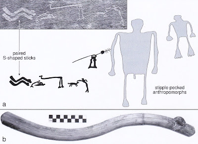
Virtually any sinuous form by itself in rock art has been identified either as a serpent, or a ‘rabbit stick’. These were once often referred to as ‘boomerangs’ as well. There is another possibility, however, that is not mentioned as often – these forms may represent fending sticks. These date back to the period before the bow and arrow when the common projectile weapon system was the atlatl and dart. Warriors could carry fending sticks to deflect the darts from an atlatl. With the right timing the dart could be deflected to the side with a sweeping movement of the fending stick held in front of you. This has actually been demonstrated as an experimental archeology project by some fearless, or crazy, graduate students.


Basketmaker II, from White Dog Cave, Arizona. Photograph from semanticscholar.org.

In the early days of archeology in the American southwest these “S-shaped” grooved sticks were usually identified as rabbit sticks or boomerangs, assuming that they were meant as a throwing weapon for small game hunting analogous to Australian aboriginal non-returning boomerangs. “Curved wooden throwing sticks, or “rabbit sticks,” also could be hurled at small game. In concept, they are not unlike the Australian boomerang, although rabbit sticks do not return to the sender. Also, known as fending sticks, the curved sticks may been used as weapons, for warding off blows in battle.” (Texas Archaeological Research Laboratory)

Rabbit Stick, Photograph B. Bernard, University of New Mexico Field School collections, 66.90.50.

When found in rock art, however, these shapes were once almost universally identified as snake images. I would argue, however, that an image intended to be a serpent would include some serpent-like details; a head, forked tongue or in the American southwest rattlesnake rattles.


Petroglyiph, anthropomorphs with S-shaped stick, John's Canyon, SE Utah. From Phil R. Geib, 2016, Fig. 11.8.

More recently the use of these items as fending sticks has gained some purchase. These fending sticks can indeed be taken as evidence of warfare. As Stephen A LeBlanc (1999) explained “There are Basketmaker rock art depictions of men holding trophy skins, there was a special form of basket used only to dry and stretch scalps, and fending sticks are commonly recovered along with atlatls. This last item may need clarification. During the earliest times in the Southwest, the bow and arrow were not present, and the atlatl was used to throw small spears or darts. With these atlatls, curved sticks with a thong that was wrapped around the user's wrist are often found. The best explanation for these sticks is that were used to fend off darts thrown by atlatls. That is, they served as a kind of shield-thus, their sole function would have been warfare. If frequency and standardization of fending sticks are any measure, warfare using atlatls was also quite common.” (LeBlanc 1999:3) In other words, the argument is that their association with images of atlatls suggests a relationship, and indicates their use as fending sticks.

Petroglyiph, anthropomorphs with paired S-shaped sticks. From Phil R. Geib, 2016, Fig. 11.4.

An explanation from the Maxwell Museum in Albuquerque gives a clear description, and suggests the relationship between fending sticks and rabbit sticks. ”The prehistoric sticks come in two basic shapes: the S-shaped version shown above, and sticks shaped like an open C. It's possible that the S-shaped sticks are older, and functioned primarily to defend the user against incoming atlatl darts. Such darts travel slowly enough that with practice, it's possible to deflect them as they approach—at least that's the theory. The S-shaped sticks are our best candidates for "fending sticks." Fending sticks became obsolete once the bow and arrow was adopted in the Southwest, about 1,400 years ago. Arrows travel too quickly to be batted to one side by the intended target. Instead, the region's warriors began using shields. Under this telling of events, the loss of the "fending" function led to the use of shorter, C-shaped sticks used primarily for throwing—the modern Pueblo "rabbit stick." (Maxwell Museum) Of course, a thrown stick can still be thought of as a weapon as well.

Petroglyiph, anthropomorphs with S-shaped sticks, Chinle Wash, Arizona. From Phil R. Geib, 2016, Fig. 11.7.

Phillip R. Geib has also led in the area of study into the use of fending sticks in the American southwest and rock art. “A defender can knock aside atlatl darts from close range with these sticks. Some tribes in South America perform a similar feat in a duel-like context and Diego de Landa may have observed an analogous ritual in the 1500s among the Yucatec Maya. The fending hypothesis is most logical in a duel. Many of the analyzed prehistoric sticks come from a known Puebloan war god shrine in central New Mexico, where an informant identified one as symbol of membership in a warrior society. In addition to prowess as a man killer, war society membership in the distant past might have involved atlatl duels where dart defense with a stick displayed great skill and courage. Basketmakers may have considered S-shaped sticks as an ancient symbol of warrior status.” (Geib 2016) This is very strong evidence of the use of these bent sticks in personal defense, and a reasonable hypothesis for their being recorded on the rocks, a record of a warrior’s personal status.


Petroglyiph, anthropomorphs with paired S-shaped sticks, Chinle Wash, Arizona. From Phil R. Geib, 2016, Fig. 11.5.

Geib backed up his researches into the use of fending sticks in the American southwest with related and contemporary examples from South America. “Deflecting atlatl darts with a short stick might seem absurd or illogical, yet certain tribes in South America still conduct duel-like atlatl fights that involve dart deflection for defense. -  - Warriors from opposing villages are paired to face each other; one is on offense first while the other is on defense, then the roles switch. The group with the greatest number of ‘hits’ is judged the winner. - - Dart defense in this South American example is achieved with a more substantial obstacle than a FCS (flat curved stick). Still, it shows that atlatl darts can be deflected or dodged, even when thrown from a close range. It is key that attention is focused on single projectiles. It is within such a rule-bound, duel-like fight that use of FCS for defense against atlatl darts makes sense: a duel would be far less risky, even if lethal tips were used. The antiquity of South American atlatl dueling remains unknown but it could be considerable given the weapons involved.” (Geib 2017)


Australian woomeras serve as spear throwers and fending sticks. Image from aboriginal-bark-painting.com.

Not only in South America can we find examples of the use of deflection for defense against the thrown spear. In Australia the aboriginal woomera (their version of the atlatl) is a multipurpose tool. Its primary use is to launch a spear for greater distance. However, it is also used as a fire making tool, a receptacle for mixing ochre in ceremonies, and also as a fending stick to deflect spears in battle. Woomeras have even been found with a stone blade set into the handle to use as a tool for working on other wooden artifacts (sort of a prehistoric Swiss Army Knife). So we have a number of examples from other parts of the world for the use of fending sticks as defense against thrown spears in conflict. Obviously, when atlatls were replaced by the bow and arrow the era for using fending sticks for personal defense was over. The smaller size and considerably greater speed of an arrow would make it virtually impossible to count on deflecting them with a fending stick, and selection would have soon removed any warriors who refused to learn that lesson.

Petroglyiph, anthropomorph with S-shaped stick. From Phil R. Geib, 2016, Fig. 11.10d.

Are these images fending sticks or rabbit sticks (non-returning boomerangs) used for hunting small game? Well, I would argue that such an image could represent either, or both at the same time. In any case these curved sticks are obviously an important tool and/or weapon, and as such likely subject matter to record in the people’s rock art.


NOTE: Some images in this posting were retrieved from the internet with a search for public domain photographs. If any of these images are not intended to be public domain, I apologize, and will happily provide the picture credits if the owner will contact me with them. For further information on these reports you should read the original reports at the sites listed below.

REFERENCES:

Geib, Phil R., 2017, Mesoamerican Flat Curved Sticks: Innovative ‘Toltec’ Short Sword, Fending Stick, or Other Purpose?, 31 August 2017, Published online by Cambridge University Press. Accessed online 12 January 2024.

Geib, Phil R., 2016, Basketmaker II Warfare and Fending Sticks in the North American Southwest, 1 May 2016, PhD dissertation, University of New Mexico, https://digitalrepository.unm.edu/anth_etds/27. Accessed online 13 January 2024.

Leblanc, Stephen A., 1999, Southwestern Warfare: Reality and Consequences, Archaeology Southwest, Spring 1999, Volume 13, Number 2, pp. 1-7. Accessed online 25 November 2023.

Maxwell Museum, undated, The Testimony of Hands: An Online Exploration of the Archaeology Collections of the Maxwell Museum, University of New Mexico, Albuquerque, New Mexico. Accessed online 13 January 2025.

Palonka, RadosÅ‚aw, 2019, Rock Art from the Lower Sand Canyon in the Mesa Verde Region, ,Colorado, USA, KIVA, 85:3, 232-256, DOI: 10.1080/00231940.2019.1643071

Texas Archaeological Research Laboratory, Undated, About Darts, Atlatls, and Other Weaponry Systems, University of Texas, Austin, Texas. Accessed online 25 November 2023. Accessed online 13 January 2025.


Saturday, April 20, 2024

NAWARLA GABARNMANG - A REMARKABLE ROCK ART SITE IN ARNHEM LAND:

The following account is about the discovery of a magnificent rock shelter in Arnhem Land, Australia, with an overwhelming amount of beautiful rock art. Of course, this ‘discovery’ only means that Western culture has finally seen it, the original inhabitants of the country always knew of it. Now that we have seen it, however, we can share its beauty with the world.

The northern Entrance of Nawarla Gabarnmang. Photograph by Bruno David, published in Antiquity, 2013.

“In June 2006, RLW and pilot Chris Morgan sighted an unusually large rockshelter during a routine aerial survey on the Arnhem Land plateau. They landed the helicopter and on walking into the open, double-ended shelter, found themselves in a stunning gallery with hundreds of rock paintings.

Nawarla Gabarnmang. Online image, public domain.

Anthropological work with senior Elders Wamud Namok and Jimmy Kalarriya enabled the Jawoyn to learn the name of the site – Nawarla Gabarnmang (nawarla=‘place of ’, gabarnmang=‘hole in the rock’). The two men had visited the shelter when they were children, and been told it was an important site where people camped en route to ceremonies on Jawoyn country. They also identified the Jawoyn clan Buyhmi as the relevant traditional owners of the site. When Buyhmi traditional owner and Elder Margaret Katherine was taken to the site, she cried out to her ancestors and wept for a place and family she had never known.” (David et al. 2011)

Jawoyn elder Margaret Katherine. Pinterest image.

This is doubtless the result of decades of Western culture’s attempts to eradicate indigenous practices and beliefs. Now that these policies have changed the aboriginal people are recovering portions of their cultural heritage that have lain dormant.


The roof, supported my many rock pillars provided a nicely sheltered place for people to stop at for a period of time. “Originally the rock pillars were not widely spaced. They were typically about one metre apart. We know this because this is how they are found in other parts of the site that people did not frequent. We can also see where missing pillars once stood, for their very tops remain adhered to the ceiling and their bases have survived on the floor in those parts of the site where the pillars are now more widely spaced. In some areas, pillars are now eight metres apart where once they stood side by side.” (David 2018)

View inside Nawarla Gabarnmang. Photograph Jean Jacques Delannoy.

This site has been in use for a very long time. “Fifty thousand years ago, Aboriginal people started to camp at the site, first at the edge and then gradually further within. Living amid the pillars was not possible at first, for they were too closely spaced. But sometime between 35,000 and 23,000 years ago – the exact timing is uncertain as more research is required – individual pillars began to be toppled. This required planned, structured dismantling, for the weight of the roof would not allow the rock pillars to be simply pushed aside. First, the pillars’ top layer was flaked away or, in some cases, vertically sectioned and removed as a block, all with stone tools, creating a space between pillar and ceiling. That space then allowed the pillars to be pushed aside and dismantled piece by piece. The overlying ceiling now lacked local support, so individual layers of ceiling rock began to collapse. Where pillars had gone, the ceiling level was now higher than in surrounding areas. The individual toppled pillar fragments and ceiling slabs were flaked into typically forty-centimetre-long pieces and carried away to the shelter’s outer edges, so that today hundreds if not thousands of regularly shaped tabular blocks abound at the rock-shelter’s northern and southern entrances. A few of those tabular pieces were left on the shelter floor and moved around. They each show signs of use, sometimes from the grinding of ochre to make paints in shades of white, red, pink, yellow and black. Others were used as anvils to rest higher-quality stone for the flaking of stone tools. It is these tabular pieces remaining on the shelter floor that local Aboriginal Elders refer to as “pillows,” demarcating where in the past people rested. The extant pillar walls and ceiling rock surfaces are heavily decorated with paintings, so much so that in some places more than thirty layers of paint have been identified, motif over motif in a time sequence that represents centuries of changing styles. And how are we to think of the accumulated slabs at the shelter’s northern and southern entrances: rejected debris to clear the site or a cache of useable tools and furniture? In some cases, slabs were overlaid in multiple tiers to make stools for artists to stand on when painting the ceiling.” (David 2018) So this location was not only painted, but first it was physically modified to fit the populations preconceptions and then decorated. This did not, of course, happen in a frenzy of deconstruction and decoration, but it seems they did have what amounts to a plan over a long period of time.


Barramundi fish on the ceiling of Nawarla Gabarnmang. Online image, public domain.

“Nawarla Gabarnmang is a spectacular site, one of the world’s great archaeological rock-shelters. Yet it is more than this. The stone workings – the systematic dismantling of the pillars, the removal of blocks to create more open spaces, their strategic disposal at both site entrances and the decoration of the remaining pillar walls and ceiling – all speak not of a natural cave but of an engineered and furnished architectural space.” (David 2018) Having finally created the space that they were satisfied with, the people then proceeded to decorate it with magnificent paintings.

Barramundi fish on the ceiling of Nawarla Gabarnmang. Online image, public domain.

“The glorious murals of the Nawarla Gabarnmang cave are vivid testimony to the cultural heritage community, social cohesion, and spirituality of the early Aboriginal settlers of Australia, who managed to create enormous beauty in a hostile environment of blistering heat and parched land, some 23,000 years before the erection of the Egyptian Pyramids or the Stonehenge Stone Circle.” (Visual Arts Cork)

This space has been painted, and repainted for millennia, but one piece of fallen stone has given a date that is truly impressive. This one dated piece “consists of a charcoal drawing made on a piece of rock, some 3 centimetres by 3 centimetres that fell from the roof during prehistory. The drawing itself comprises 2 crossed lines: one is straight, while part of the other is slightly curved. The area formed by the curved part has been filled in with a heavier (thus darker) application of charcoal, but the rest of the drawing is faded beyond recognition. The stone fragment is aged between 28,000 and 45,600 years old, while the charcoal drawing is dated to 26,000 BCE. The drawing is broadly contemporaneous with the Fumane Cave paintings in Italy (c.35,000 BCE) and the Chauvet Cave paintings in France (c.30,000 BCE), both painted during the era of Aurignacian in Europe. Despite its advanced age, Gabarnmang's charcoal drawing is unlikely to be northern Australia')s most ancient art. This honour is likely to go to the cupule art or hand stencils of the Kimberley region, which are believed to date to at least 30,000 possibly 40,000 BCE.” (Visual Arts Cork)

Palimpsest at Nawarla Gabarnmang. Online image, public domain.

The studies indicated that people have occupied Nawarla Gabarnmang for a very long period of time indeed. “Initial results at Nawarla Gabarnmang have revealed secure evidence of people some 45,000 years ago. Ongoing excavations are aimed at tracking the >45,000 year old levels, dating the rock art and further investigating the site’s geomorphology (including anthropogenic  modifications to the ceiling and pillars).” (David 2011)

So, at roughly the same period of prehistory that humans were painting the natural caves of Europe, the people of Arnhem Land, Australia, were, in effect, creating their own cave before painting it extensively.

NOTE: Some images in this posting were retrieved from the internet with a search for public domain photographs. If any of these images are not intended to be public domain, I apologize, and will happily provide the picture credits if the owner will contact me with them. For further information on these reports you should read the original reports at the sites listed below.

REFERENCES:

David, Bruno et al., 2011, Nawarla Gabarnmang, a 45,180±910 cal BP Site in Jawoyn Country, Southwest Arnhem Land Plateau, Australian Archaeology, No. 73 (December 2011), pp. 73-77. Accessed online 31 December 2023.

David, Bruno et al., 2018, Nawarla Gabarnmang, 25 September 2018, Landscape Australia, https://landscapeaustralia.com/articles/nawarla-gabarnmang/. Accessed online 31 December 2023.

Gunn, Robert et al., 2017, The past 500 years of rock art at Nawarla Gabarnmang, central-western Arnhem Land, pp. 303-328, from The Archaeology of Rock Art in Western Arnhem Land, Australia, edited by Bruno David, Paul Tacon, Jean-Jacques Delannoy, and Jean-Michel Geneste, Australian National University Press, Canberra, Australia.

Visual Arts Cork, Nawarla Gabarnmang Charcoal Drawing (26,000 BCE), http://www.visual-arts-cork.com/prehistoric/nawarla-gabarnmang.htm. Accessed online 31 December 2023.