Showing posts with label Neolithic. Show all posts

Saturday, March 18, 2023

11,000 YEAR-OLD SCENE MAY BE THE OLDEST KNOWN NARRATIVE:

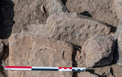
Relief panel, Sayburç, Turkey. Photograph, the Sayburç Project.

Excavations at Sayburç, in south-eastern Turkey in 2021, have exposed ancient ruins including a relief carving that is being called the World's oldest narrative. "Narrative - the representation in art of an event or story" (Merriam Webster online dictionary, accessed 16 January 2023). So, this says to me that a single image could not be classified as a narrative, although it could be a single scene out of a narrative. A narrative implies the passage of some time - this happened, then that.

Panoramic view of the relief panel, Sayburç, Turkey. Photograph, the Sayburç Project.

In 2021, at Sayburç, "a relief was discovered in a communal building that displays a scene depicting humans and animals. This scene has the narrative integrity of both a theme and a story, in contrast to other contemporaneous images, and represents the most detailed depiction of a Neolithic 'story' found to date in the Near East, bringing us closer to the Neolithic people and their world." (Özdoğan 2022) This is analagous of an eleven thousand year old picture book.


Close-up details of central figure and facing leopard heads, Sayburç, Turkey. Photograph, the Sayburç Project.

"The site of Sayburç comprises a Neolithic mound, located 60 km east of the Euphrates River, on the southern periphery of the eastern Taurus mountains. It was mostly covered by the construction of the modern village of Sayburç in 1949, after which the site takes its name. Excavation began in 2021, which revealed two separate Pre-Pottery Neolithic occupations. The first, which comprises communal buildings, is located in the northern part of the village, on the south-eastern edge of a small Roman settlement. The second, consisting of residential buildings, is located 70m further south. The communal building containing the relief was discovered in the northern occupation area. Here, two modern houses, one of stone, the other of concrete, had been constructed over the remains. To date, only half of the building has been excavated. The modern houses will be demolished in future field seasons to enable the Neolithic structure to be exposed in its entirety." (Özdoğan 2022) It is remarkable how many recent discoveries of the very first stages of civilization seem to come out of this area.

View of the excavation from above. Sayburç, Turkey. Photograph, the Sayburç Project.

"The communal building measures 11m in diameter, and was carved into the livestone bedrock, with stone-built walls that rest on a bench, which rises from the floor. The bench measures approximately 0.6-0.8m high and 0.6m wide and displays a number of ~0.4m-wide cavities extending along the wall, suggesting that it had originally been partitioned by pillars. The images engraved on the inner face of the bench, in combination with the size and structural features of the building, suggest that this must have been a place for special gatherings." (Özdoğan 2022) If this is the case, that it was meant for special gatherings, then that implies the images were meant for the population, public display, not private. It quite possibly represents scenes from a myth or legend that everyone in the community would know, and they would recognize these.

Map of the area with Sayburç toward lower left, Gobekli Tepe near center. Map from cambridge.org.

“Five figures are represented side-by-side on the inner face of the bench in the form of a 0.7-0.9 x 3.7m panel. Aside from a male figure fashioned in high relief, the other figures are carved in flat relief. The direction and stance of the figures imply that two related scenes are present. While the other figures are facing on another, only the male figure - in high relief - faces into the room, staring into the interior. This principal human figure holds it phallus in its right hand. -  the rounded protrusions on the upper end of the legs appear to represent the knees, as if bent forward while sitting, and provide perspective. Although the head is damaged, a round face, large ears, bulging eyes and thick lips are evident. In particular, a triangular-shaped necklace or neckband is notable. This male figure is faced on each side by two leopards which are depicted in profile. Their mouths are open, the teeth visible, and their lang tails are curled up towards the body. The leopard to the west is depicted with a phallus, whereas the other is not." (Özdoğan 2022)

The five figures visible in the relief carving comprise two leopards, one bull, and two humanoid male figures. These quite possibly actually represent a single humanoid involved in two different activities or events, like two scenes in the story or two acts in a play. And, I say humanoid because his status is unknown. He may represent a mere mortal, a cultural hero or a sacred being, a demi-god or god. This may be an early manifestation of a being like Gilgamesh.

Left side of second panel, Sayburç, Turkey. Photograph, the Sayburç Project.

Right side of second panel, Sayburç, Turkey. Photograph, the Sayburç Project.

"To the west is a similar scene, in which a second human figure and a bull are depicted side on. The human appears to be male, with a phallus-shaped extension on the abdomen, and is shown in a slightly squatted position, with its back turned to the first three figures. Its raised, open left hand has six fingers, while the right holds a snake, or a rattle, with its head facing the ground. Although the body of the bull is portrayed from the side, its head is depicted as if from above with both horns visible. This distorted perspective is comparable to that seen at other prehistoric sites and must have been deliberately chosen to emphasize the horns, which are exaggerated like the leopards' teeth in the previous scene." (Özdoğan 2022)

"The Sayburç reliefs correspond to the style and themes of the Neolithic. Phalluses are the only elements identifying the sex of the figures, and emphasis is placed on predatory and aggressive aspects of the animal world, as represented by the depiction of dangerous features, such as teeth and horns, which has been observed at other sites." (Özdoğan 2022)

This emphasis on the threatening nature of the animals suggest the "Master of animals" theme often suggested by Neolithic art. The authors suggest a relationship to Gobekli Tepe, and the bull's horns may also indicate some relationship to Çatalhöyük. And, as I stated above the figure's interaction with a bull may indicate a very early manifestation of an epic like the story of Gilgamesh.  

NOTE: Some images in this posting were retrieved from the internet with a search for public domain photographs. If any of these images are not intended to be public domain, I apologize, and will happily provide the picture credits if the owner will contact me with them. For further information on this reports you should read the original report at the site listed below.

REFERENCES:

Merriam Webster Online Dictionary, accessed 7 January 2023.

Özdoğan, Eylem, 2022, The Sayburç reliefs: a narrative scene from the Neolithic, Antiquity, Vol. 96, Issue 390, December 2022, pp. 1599-1605, published online by Cambridge University Press, 8 December 2022. Accessed 7 January 2023.


Saturday, March 5, 2022

ANOTHER GAME BOARD PETROGLYPH:


Omani game board, Qumayrah Valley, Oman. Photograph J. Sliwa, Polish Centre of Mediterranean Archaeology, University of Warsaw, Poland.

I have, in the past, written a few columns about petroglyphs that seem to be intended as game boards. There is now a new report about another one found in Oman by a joint project between the University of Warsaw and the Omani Ministry of Heritage and Tourism.

“The work is carried out by an Omani-Polish project ‘The development of settlement in the mountains of northern Oman in the Bronze and Iron Ages’ headed jointly by Prof. Piotr Bielinski from the Polish Centre of Mediterranean Archaeology, University of Warsaw (PCMA UW) and Dr. Sultan al-Bakri, Director General of Antiquities at the Ministry of Heritage and Tourism (MHT) of the Sultanate of Oman.” (ASZY 2022)

Oman is located on the southeast tip of the Arabian Peninsula adjacent to the Indian Ocean and the ruins are near the village of Ayn Bani Saidah in the Qumayrah Valley in the north of the Sultanate of Oman. (ASZY)

“In the latest study, the researchers identified an ancient settlement from the Umm al-Nar period (2500-2000 BC), where they unearthed the remains of several large circular towers and Bronze Age buildings.” (HeritageDaily 2022)


Closeup of Omani game board, Qumayrah Valley, Oman. Photograph J. Sliwa, Polish Centre of Mediterranean Archaeology, University of Warsaw, Poland.

“In one of the rooms we’ve found…a game-board – beams the project director. The board is made of stone and has marked fields and cup-holes. Games based on similar principles were played during the Bronze Age in man economic and cultural centers of that age. Such finds are rare, but several examples are known from India, Mesopotamia and even the Eastern Mediterranean basin.” (ASZY 2022) Unfortunately, none of the references identified which of the co-directors of the project this quotation should be attributed to.


10th century ivory board from Muslim Spain, Museum of Burgos, photograph Wikipedia.

The board appears to have 14 holes carved into what looks in the photos to be a block of limestone. It seems to be intended for use in a variant of the family of games known as Mancala in which seeds or stones are moved from pit to pit to either capture an opponent’s pieces, or to bank the most pieces for yourself. (Wikipedia)

“Researchers also found evidence of processing copper at the site, as well as several copper objects, suggesting that the settlement participated in this lucrative trade for which Oman was famous at that time, with mentions of Omani copper present in the cuneiform texts from Mesopotamia.” (HeritageDaily 2022)

I think that we can assume that any group of people who have the leisure time to play board games are, if not prosperous, at least secure in their environment, and emotionally relaxed enough to enjoy themselves, and this game board would seem to prove this. I can picture prosperous copper merchants relaxing with a game of mancali. There is, however, another possibility, that this is a counting board. These work on the same principle as an abacus with each hole in each marked off sector having a value. The operator can essentially do fairly complicated mathematical operations by placing, moving, or removing counters between the various valued holes. If this were the case we need to picture the prosperous copper merchants calculating their profits. Remembering, however, that the board appears to have 14 holes I know of no mathematical system that would require 14 holes to work.

NOTE: Some images in this posting were retrieved from the internet with a search for public domain photographs. If any of these images are not intended to be public domain, I apologize, and will happily provide the picture credits if the owner will contact me with them. For further information on these reports you should read the original reports at the sites listed below.

REFERENCES:

ASZY, 2022, Qumayrah Valley in Oman: ancient towers, copper trade and games, 4 January 2022, Polish Centre of Mediterranean Archaeology, University of Warsaw, accessed 8 January 2022

HeritageDaily, 2022, Archaeologists discover 4,000-year-old stone board game, https://www.heritagedaily.com, accessed 7 January 2022.

Wikipedia, Mancala, https://en.wikipedia.org/wiki/Mancala, accessed 9 January 2022

Saturday, November 21, 2020

NEOLITHIC PETROGLYPHS AT QUBBET-EL-HAWA, EGYPT:


Qubbet El-Hawa, Egypt. Photo David Sebel.

A recently discovered petroglyphs at Qubbet El-Hawa (Cave of the Winds) along the Nile river in Egypt is estimated to be 6,000 years old. "The image, discovered recently by archaeologists, provides a tantalizing glimpse of Egypt's Neolithic period, or Stone Age. It likely dates back to the latter half of the fourth millenium B.C., said Ludwig Morenz, and Egyptologist at the University of Bonn in Germany." (Pappas) This date would mean that the images at Qubbet El-Hawa predate the pharaohs and provide a glimpse into very early life along the Nile river.


     Qubbet El-Hawa, Egypt. Photo David             Sebel - photo enhanced.

"Qubbet el-Hawa is a site on the western bank of the Nile, opposite Aswan. The name is derived from the dome of the tomb of an Islamic sheikh, but archaeologically, it is usually understood as referring to the site of the tombs of officials lined up on artificial terraces below the summit of the Nile bank upon which the Islamic tomb stands." (Wikipedia)


Panel with conceptual drawing of what they think they see. David Sabel.

"The scene is interpreted by Morenz as a hunter with a bow standing next to an ostrich. On the other side of the ostrich is a person who seems to be wearing an ostrich mask. Morenz believes that the person might be a shaman and the mask-wearing might indicate ritual purposes." (Pappas)

Actual tracing of the panel. David Sabel.

"The images were pecked into the rock with a hard point and are now barely perceivable due to their considerable age. Only the archaeologically precise recording of the traces and the drawing of outlines revealed the images with noteworthy iconography. The initially confusing-looking arrangement of dots allows three figures to be seen upon closer inspection: a hunter with bow, and dancing man with raised arms, and between them, an African ostrich. 'The archer clearly shows hunting for the large flightless bird, while the man with raised arms can be identified as a hunt dancer,' reports Prof. Morenz. The dancer apparently wears a bird mask. The scene is reminiscent of the conceptual world of hunting, masks, and shamanism, as known from many parts of the Earth - including ostrich hunting by what are known as San (bushmen)." (University of Bonn 2017)

While I agree that they have found petroglyphs, to identify these figures in such detail does not seem to me to be warranted. Looking at the photographs and the field drawings the best I can say is that there seem to be three figures. Yes, one of them appears to have a bow, and the one in the center might be an ostrich, but that is pushing the limit of reasonable interpretation. I see nothing to suggest dancing and there is no indication of mask wearing. I fear that we have another case of Pareidolia, perhaps perhaps combined with an example of the Availability Heuristic.

“The availability heuristic involves making decisions based upon how easy it is to bring something to mind. When you are trying to make a decision, you might quickly remember a number of relevant examples. Since these are more readily available in your memory, you will likely judge these outcomes as being more common or frequently-occurring.” (Cherry 2020)  While I cannot know this for certain I suspect that Professor Morenz has, at some point, studied examples of San rock art which not only include ostriches, but are sometimes interpreted as showing ecstatic dancing, so this is what he saw. Pareidolia is the tendency of the human mind to interpret something as a familiar object - the old pony in the clouds, for example - and Morenz was looking for the meaning of the pecking on this panel. Not that I can say that his interpretation could not be possible, just that I don’t think he has enough data to make such definitive statements.

So, while I congratulate the team on a discovery that is significant, and important to Egyptian prehistory, I must say that I cannot agree with their interpretation based upon the evidence available.

NOTE: Some images in this posting were retrieved from the internet with a search for public domain photographs. If any of these images are not intended to be public domain, I apologize, and will happily provide the picture credits if the owner will contact me with them. For further information on these reports you should read the original reports at the sites listed below.

REFERENCES:

Cherry, Kendra, 2020 Heuristics and Cognitive Biases, https://www.verywellmind.com/what-is-a-heuristic-2795235

Pappas, Stephanie, 2017 Ancient Rock Carvings Depicting Masked People Discovered in Egypt, March 24, 2017, Live Science, http://www.livescience.com/58394-ancient-egyptian-rock-carvings-discovered.html?utm_source=ls-newsletter&utm_medium=email&utm_campaign=20170324-ls

University of Bonn, 2017 Egyptian Ritual Images from the Neolithic Period, March 22, 2017, https://phys.org/news/2017-03-egyptian-ritual-images-neolithic-period.html

https://en.wikipedia.org/wiki/Qubbet_el-Hawa

Saturday, September 21, 2019

WHAT THE HELL ARE THEY? – NEOLITHIC CARVED STONE BALLS:


Neolithic stone balls,
Ashmolean Museum,
Internet, Public Domain.


Carved Stone Ball from
the British Museum,
Wikipedia,
Public Domain.

Here is one of my favorite conundrums involving rock art. These Neolithic carved stone balls – what the hell are they? “Carved stone balls are petrospheres dated from the late Neolithic to possibly as late as the Iron Age mainly found in Scotland, but also elsewhere in Britain and Ireland. They are usually round and rarely oval, and of fairly uniform size at around 2.75 inches or 7 cm across, with 3 to 160 protruding knobs on the surface. They range from having no ornamentation (apart from the knobs) to extensive and highly varied engraved patterns.” (Wikipedia) Originally thought to be associated with the Picts, these are now known to date from the Neolithic to Iron Ages, and thus predate the Picts who arose in the Late Iron Age.

Alford ball, Wikipedia,
Public Domain.


Towie Ball, from Scotland,
Internet photo,
Public Domain.

Towie Ball, from Scotland.
Wikipedia drawing,
Public Domain.

Suggested uses range from weapons (like mace heads, bolas, or sling stones) to tools (grinders like pestles, rollers like ball bearings for the stone blocks used to build Stonehenge, weights for fishing nets), standardized weights for traders, and of course the fall back for when you don’t really know anything, “objects of ritual significance or social status.” They have also been explained as perhaps functioning like the “speaker’s staff” to control or order deliberation in meetings. 

I would like to suggest another possibility related to the concept of social status. How about tokens of wealth like the “coppers” of the Indians of the Northwest coast of North America, or Rai (the stone money of the island of Yap). Tokens of wealth depend for their value on rarity. Rarity, in turn, depends upon how hard it is to procure the object in question because of either scarcity of the raw material or because of difficulty of fabrication.

North American Northwest
Coast Indian copper,
picture from Internet,
Public Domain.

In the case of the coppers prehistorically the material was very rare and hard to procure prehistorically for the native people, as well as the effort to produce the item was great. “Coppers, which are still in use today, experienced a real golden age in the 19th and the beginning of the 20th century. Due to contacts with western explorers and merchants their production increased substantially. However there are several indications that suggest they were already in use before the first contacts with the West, about 1790. The coppers were an exceptionally important symbol in the northwestern societies of the American continent. Apart from being a means of payment in a complex system of transactions, they were also a symbol of wealth and prestige.” (nbbmuseum.be)


Rai, stone money from the
island of Yap. Picture
intchyfeetphotography.com,
Public Domain.

And in the case of the Rai the production of the pieces involved a difficult process of stone carving as well as a sea voyage to and from the quarry on a different island. “Rai, or stone money (Yapese: ray), are more than 6,000 large, circular stone disks carved out of limestone formed from aragonite and calcite crystals. Rai stones were quarried on several of the Micronesian islands, mainly Palau, but briefly on Guam as well, and transported to Yap for use as money.” (Wikipedia) There is no limestone naturally on the island of Yap – thus scarcity. And, of course, prehistorically they had no metal tools so it took considerable effort to create them. When metal tools were introduced after contact Rai became much easier to create and this caused economic inflation and depreciation in the value of the Rai, but they are still held to be important by the people.

Glasgow Ball, Scotland.
Wikipedia,
Public Domain.


Stone Ball, Photo
ancientorigins.net,
Public Domain.

Stone Ball, Internet
photo. Public Domain.

The value of these stone balls does not depend on scarcity of material, hard rocks are abundant in their homeland. It therefore depends on the difficulty of crafting them. It undoubtedly took considerable effort and precision to create most of these stone balls. “Many are said to be made of “greenstone”, but this is a general term for all varieties of dark, greenish igneous rocks, including diorites, serpentinite, and altered basalts. Forty-three are sandstone, including Old Red Sandstone, 26 greenstone and 12 quartzite. Nine were serpentinite and these had been carved. Some were made of gabbro, a difficult material to carve. Round and oval natural shaped sandstones are sometimes found. Examples made from Hornblende gneiss and granitic gneiss were noted, both very difficult stone to work. Granitic rocks were also used and the famous Towie example may be serpentinised picrite. The highly ornamented examples were mainly made of sandstone or serpentine.” (Wikipedia)

Elgin petrosphere, slate ball.
Internet photo, Public Domain.

“By the late 1970s a total of 387 had been recorded. Of these, by far the greatest concentration (169) was found in Aberdeenshire. By 1983 the number had risen to 411 and by 2015 over 425 balls had been recorded. A collection of over 30 carved balls from Scotland, Ireland and northern England are held by the British Museum.” (Wikipedia)

Some of these are fairly crude but many of them are examples of great precision and craftsmanship in their manufacture. I love the mystery here. Along with objects of considerable rarity, some of them are of beautiful design and execution, and no-one knows what they were for. We might as well call them dragon eggs. But they are rock, and artistic – thus, Rock Art.

NOTE: Some images in this posting were retrieved from the internet with a search for public domain photographs. If any of these images are not intended to be public domain, I apologize, and will happily provide the picture credits if the owner will contact me with them. For further information on these reports you should read the original reports at the sites listed below.

REFERENCES:

https://en.wikipedia.org/wiki/Carved_stone_balls

https://en.wikipedia.org/wiki/Rai_stones

https://www.nbbmuseum.be/en/2007/07/the-coppers-of -america.htm

Metcalfe, Tom
2018 Enigmatic Stone Balls from 5,000 Years Ago Continue to Baffle Archaeologists, June 18, 2018, Live Science, https://www.livescience.com/62843-enigmatic-stone-balls-scotland.html

Saturday, December 8, 2018

GOBEKLI TEPE AND THE "MAGICIANS OF THE GODS, " BY GRAHAM HANCOCK:


Pillar 43, Gobekli Tepe, Turkey.

I have recently posted a couple of columns on the remarkable temples of Gobekli Tepe in Turkey. In these, I have expressed my fascination at the level of sophistication, and artistic accomplishment, achieved at this very early stage in the history of human culture. With something as remarkable as Gobekli Tepe, it is perhaps inevitable that fringies begin to find "hidden secrets" and predictions of coming catastrophe in it. These are perhaps best expressed in Magicians of the Gods by Graham Hancock, wherein he explains the theory that art work on one of the pillars at Gobekli Tepe actually portrays the Mayan calendrical standstill.


The pillar 43 chart of constellations,
Gobekli Tepe, Graham Hancock,
Magicians Of The Gods. Figure 50.

Hancock was apparently pointed in the right direction by the writings of Paul D. Burley who discovered great astronomical meanings in Gobekli Tepe. Such is the case with the remarkable relief carvings on pillar 43. "There is a bird with outstretched wings, two smaller birds, a scorpion, a snake, a circle, and a number of wavy lines and cord-like features. At first glance this lithified menagerie appears to be simply a hodgepodge of animals and geometric designs randomly placed to fill in the broad side of the pillar. The key to unlocking this early Neolithic puzzle is the circle situated at the center of the scene. I am immediately reminded of the cosmic Father - the sun. The next clues are the scorpion facing up toward the sun, and the large bird seemingly holding the sun upon an outstretched wing. In fact, the sun figure appears to be located accurately on the ecliptic with respect to the familiar constellation of Scorpio, although the scorpion depicted on the pillar occupies only the left portion, or head, of our modern conception of that constellation. As such, the sun symbol is located as close to the galactic center as it can be on the ecliptic as it crosses the galactic plane." (Burley 2013)


The pillar 43 chart of constellations
diagrammed, Gobekli Tepe,
Graham Hancock, Magicians
Of The Gods. Page 310. 

Burley's analysis brings a couple of problems to mind for me. First, you cannot see any constellations in the sky when the sun is out and among them. You only see constellations at night when the sun is gone and the sky is dark. Why would the sun be illustrated in the middle of a star map of the night sky? Second, Burley makes great significance out of the precision of the location of this sun disk, yet the sun moves constantly while the constellations are essentially fixed for any earthbound observer. Even if you could see the sun with the constellations in the sky it would only be in any one position for an instant.


Pillar 43 with the modern
equivalent constellations,
Gobekli Tepe, Graham Hancock,
Magicians Of The Gods. Figure 51.

Hancock, however, believes Burley hook, line, and sinker, but adds his own interpretation to the meaning of this star chart. It did not represent the sky back at the time Gobekli Tepe was constructed. No, it presages the sky of present-day earth. Hancock's computer work with sky simulation software proved to him that the carvings on pillar 43 were intended as some sort of message to us today. "By a process of elimination we have seen that Gobekli Tepe cannot be inviting us to consider the equinoxes, and nor can it be inviting us to consider the summer solstice, even at the favorable moment of sunset. This leaves us only with the winter solstice with the sun in Sagittarius targeting the center of the Milky Way galaxy, the definitive astronomical signature of the years between 1960 and 2040 in our own epoch - a signature that recurs only at 26,000-year intervals." (Hancock 2015:332)


Hancock's speculated constellations
charted on pillar 43, Gobekli Tepe,
Graham Hancock, Magicians Of
The Gods, Page 320.

Another comparable scientific achievement of prehistoric antiquity that survived the ages and came down to us in the same degree of completeness is the Mayan calendar "that envisaged a great cycle in the life of the world coming to an end in exactly the same 80-year period between 1960 and 2040." (Hancock 2015:333)

If I understand Hancock, the point of all of these predictions pointing to the 80-year period between 1960 and 2040 CE, is the danger of a collision with a comet. He cites a number of references to authors speculating about the possibility of large bodies in the Taurid meteor stream. "Calculations indicate that this presently invisible object at the heart of the Taurid stream might be as much as 30 kilometers in diameter. Moreover, it is thought that other large fragments accompany it." (Hancock 2015:438) Hancock's date for this disastrous collision with the earth is apparently 2030.

"The Taurids are an annual meteor shower associated with the comet Encke. The Taurids are actually two separate showers, with a Southern and a Northern component. The Southern Taurids originated from Comet Encke, while the Northern Taurids originated from the asteroid 2004TG. They are named after their radiant point in the constellation Taurus." (Wikipedia)

So now we know, both the ancient inhabitants of Gobekli Tepe, with their predictions on pillar 43, and the ancient Mayans whose calendar ended in our era because there was no point in continuing it, we are all going to be extinct, had knowledge somehow of this impending doom. Perhaps that is the "Magic" of his title, that they somehow knew about this.

I think it is really a shame to clutter up the knowledge and awareness of a magnificent place like Gobekli Tepe with this nonsense. The amazing architecture from such an early period, with the beautifully sophisticated imagery should be enough, but, for Catastrophe Theorists and the flim-flam authors who sell that stuff it never is.  

NOTE: Some images in this posting were retrieved from the internet with a search for public domain photographs. If any of these images are not intended to be public domain, I apologize, and will happily provide the picture credits if the owner will contact me with them. For further information on these subjects you should read the originals at the sites listed below.

REFERENCES:

Burley, Paul D.,
2013 Communicating Ancient Cosmic Geography, March 8, 2013, http://asabovesobelow-pauldburley.com/

Hancock, Graham
2015 Magicians of the Gods, St. Martin's Press, New York.

https://en.wikipedia.org/wiki/Taurids

Saturday, December 1, 2018

ASTRONOMY IN ROCK ART - DECODING GOBEKLI TEPE?


Gobekli Tepe, Pillar 43,
www.look4ward.co.uk,
Public Domain.


Now, to dig a little deeper into the phenomenon of Gobekli Tepe. Readers of RockArtBlog will recognize that I have an interest in the subject of natural phenomena in rock art, among these the science of astronomy. I have long believed that any remarkable natural phenomena will tend to be recorded by the people who observed them. Among these phenomena would be the close approach of a comet. Now two researchers from the University of Edinburgh have proposed that some of the marvelous carvings at Gobekli Tepe record just such an occurrence.

The remarkable recent discoveries at Gobekli Tepe, in Turkey, have given us very early architecture decorated with sophisticated stone carvings, but they have also given us (as all such discoveries seem to) new controversies concerning archaeoastronomy and the supposed comet strike that caused the Younger Dryas.

"The Younger Dryas (c. 12.900 to c. 11,700 BP) was a return to glacial conditions which temporarily reversed the gradual climatic warming after the Last Glacial Maximum started receding around 20,000 BP. It is named after an indicator genus, the alpine-tundra wildflower Dryas octopetala, as its leaves are occasionally abundant in the Late Glacial, often minerogenic-rich, like lake sediments of Scandinavian lakes." (Wikipedia)


Gobekli Tepe, Pillar 43,
Public Domain.

Gobekli Tepe, Turkish for "Potbelly Hill", is an archaeological site in the Southeastern Anatolia Region of Turkey, approximately 12 km (7 mi) northeast of the city of Sanliurfa. The tell has a height of 15 m (49 ft) and is about 300 m (980 ft) in diameter. It is approximately 760 m (2,490 ft) above sea level.
The tell includes two phases of use believed to be of a social or ritual nature dating back to the 10th - 8th millennium BCE. During the first phase, belonging to the Pre-Pottery Neolithic A (PPNA), circles of massive T-shaped stone pillars were erected - the world's oldest known megaliths. More than 200 pillars in about 20 circles are currently known through geophysical surveys. Each pillar has a height of up to 6 m (20 ft) and weighs up to 10 tons. They are fitted into sockets that were hewn out of the bedrock." (Wikipedia) It is these pillars which we are concerned with here. They are remarkably carved with low relief images and symbols, some have 3-dimensional animals, and human appendages making them stylized standing human figures.

Martin Sweatman and Dimitrios Tsikritsis, of the School of Engineering, University of Edinburgh, King's Buildings, Edinburgh, Scotland, have analyzed carvings on some of these pillars and deciphered them to tell an amazing tale. Sweatman and Tsikritsis claim they are a record of the huge comet strike that caused the Younger Dryas by reversing the climate warming, putting earth back into ice age conditions for 1,000 years. This comet strike has been amazingly difficult to locate, no remaining physical has been found so far. This has led to theories that state that the comet may have hit the earth on the ice sheet covering Canada during the late glacial age, leaving no crater in the ground.


Gobeckli Tepe, carved pillar,
the lower image is a fox.
LaStampa.it, Public Domain.

"As they are central to this work we will describe in detail a few of the key pillars of interest and their corresponding carvings. The key to unlocking our interpretation of GT is pillar 43, Enclosure D, also known as the ‘Vulture Stone’ (see Figure 1). Enclosure D is formed of a rough circular wall with eleven large upright megaliths embedded into its inner surface (once there were perhaps twelve), protruding upwards and inwards. Near the centre of the enclosure stand a pair of massive hammer-shaped megaliths, each weighing around 15 tonnes with some anthropomorphic features. We will come back to them. Pillar 43 is embedded into the north-west of the enclosure. Striking images of this pillar can be found in the academic literature and across the internet. Indeed, pillar 43 is one of the defining images of Göbekli Tepe, and has been called ‘the world’s first pictogram’." (Sweatmen and Tsikritsis, 2017)

Sweatman and Tsikritsis proceed through a very complex analysis of the imagery on pillar 43 to the conclusion that it records a dated astronomical occurrence in 10950 BC ± 250 yrs, roughly coinciding with the end of the Younger Dryas - why not the date of the event that they say began the Younger Dryas I am not able to understand. As I understand them, they say that pillar 43 sets the date and implies a catastrophe occurred, and pillar 18 indicates that it was a comet. How did the inhabitants of Gobekli Tepe, who produced this record, know of something that happened 2,000 years earlier?

"We have interpreted much of the symbolism of Göbekli Tepe in terms of astronomical events. By matching low-relief carvings on some of the pillars at Göbekli Tepe to star asterisms we find compelling evidence that the famous ‘Vulture Stone’ is a date stamp for 10950 BC ± 250 yrs, which corresponds closely to the proposed Younger Dryas event, estimated at 10890 BC. We also find evidence that a key function of Göbekli Tepe was to observe meteor showers and record cometary encounters. Indeed, the people of Göbekli Tepe appear to have had a special interest in the Taurid meteor stream, the same meteor stream that is proposed as responsible for the Younger-Dryas event. Is Göbekli Tepe the ‘smoking gun’ for the Younger-Dryas cometary encounter, and hence for coherent catastrophism?" (Sweatman and Tsikritsis)

The date designated has been arrived at by assuming the circle seen in what is roughly the center of pillar 43 (the Vulture Stone) as the sun, and the other images on the face are identified as constellations. Apparently running the (assumed) identified constellations back in a computer to the positions they occupy on pillar 43 gives the date 10950 BCE ± 250. The other pillar involved in this interpretation is pillar 18 of Enclosure D. Its imagery identifies the causal event of the Younger Dryas, a comet strike on earth. The comet is proven by the image of a fox with the foxes' tail representing the comet. (Sweatman and Tsikritsis)

I have read their paper and I must say I am not convinced. They state, in many instances, that some carved symbol carries a certain meaning, but present no evidence to back that up. We have the same criticisms here that I have found pertinent in other claimed prehistoric star charts, and a star chart is exactly what they are claiming pillar 43 is. However, a picture of a scorpion provides absolutely no proof whatsoever that the ancient inhabitants identified the same Scorpio constellation as we do, or any Scorpio constellation at all, for that matter. They might have seen those stars as representing anything at all. They might have looked up at the constellation of the rabbit's genitals for all we know. A picture of a scorpion proves nothing. I will look more deeply into these constellations and star charts in my next column.

It is, perhaps, inevitable that catastrophe theorists would find ways to involve something as remarkable as Gobekli Tepe in their crazy ideas. The press has loved this story by Sweatman and Tsikritsis, but I have not found much in the way of assent from the scientific community. It is a shame that some people cannot just admire it for what it is, amazingly early examples of temple architecture and remarkable artwork combined in one place, produced thousands of years earlier than most other known examples, a miracle of human creativity. Not everything encodes secret messages! I do, however, urge you to read their paper for yourself and make up your own mind. 

NOTE: Some images in this posting were retrieved from the internet with a search for public domain photographs. If any of these images are not intended to be public domain, I apologize, and will happily provide the picture credits if the owner will contact me with them. For further information on these reports you should read the original listed below.

REFERENCES:

Sweatman, Martin B., and Dimitrios Tsikritsis
2017 Decoding Gobekli Tepe With Archaeoastronomy: What Does The Fox Say?, p. 233-50, Mediterranean Archaeology and Archaeometry (open access), Vol. 17, No. 1.

https://en.wikipedia.org/wiki/Göbekli_Tepe

https://en.wikipedia.org/wiki/Younger_Dryas

LaStampt.it

www.look4ward.co.uk

www.suggestkeywords

Sunday, November 25, 2018

GOBEKLI TEPE - 12,000-YEAR-OLD TEMPLES?


View of Gobekli Tepe temple excavation, tse2.mm.bing.net,
Public Domain.

I am writing this as an introduction to the remarkable phenomenon of Gobekli Tepe. I have no intention to make this any more than a simple introduction, in hopes of inspiring you, my readers, to dig in to the subject yourselves. Gobekli Tepe will reward your efforts.


Pillar with relief sculpture,
birds and boar,
3.bp.blogspot.com-gobekli-tepe-3,
Public Domain.

"Gobekli Tepe, Turkish for "Potbelly Hill", is an archaeological site in the Southeastern Anatolia Region of Turkey, approximately 12 km (7 mi) northeast of the city of Sanliurfa. The tell has a height of 15 m (49 ft) and is about 300 m (980 ft) in diameter. It is approximately 760 m (2,490 ft) above sea level. The tell includes two phases of use believed to be of a social or ritual nature dating back to the 10th - 8th millennium BCE. During the first phase, belonging to the Pre-Pottery Neolithic A (PPNA), circles of massive T-shaped stone pillars were erected - the world's oldest known megaliths. More than 200 pillars in about 20 circles are currently known through geophysical surveys. Each pillar has a height of up to 6 m (20 ft) and weighs up to 10 tons. They are fitted into sockets that were hewn out of the bedrock." (Wikipedia)


Gobekli Tepe, pillar carved
with arms and a belt,
www.ancient-origins.net,
Public Domain.

The main site of Gobekli Tepe consists of a series of circular constructions as described above. Remarkably, each one was apparently used for some time and then buried, with a new circular construction built for use. Four of the circular constructions have been excavated with a probably 16 more still to be investigated. Indeed, T-shaped stone pillars have reportedly been found on a number of other hilltops in the region indicating the possibility that the phenomenon of Gobekli Tepe was widespread. (Wikipedia)


Lion and boar on a pillar
at Gobekli Tepe,
tse1.mm.bing.net,
Public Domain.

Gobekli Tepe is classified as a Pre-Pottery Neolithic A Period site, and "is a series of mainly circular and oval-shaped structures set on the top of a hill. Excavations began in 1995 by Prof. Klaus Schmidt with the help of the German Archeological Institute. There is archeological proof that these installations were not used for domestic use, but predominately for ritual or religious purposes. Excavations and geo-magnetic results revealed that there are at least 20 installations, which in archeological terms can be called a temple. Based on what has been unearthed so far, the pattern principle seems to be that there are two huge monumental pillars in the center of each installation, surrounded by enclosures and walls, featuring more pillars in those set-ups." (gobeklitepe.info)


Three-dimensional lion
carved on a pillar,
gobeklitepe.info,
Public Domain.

It is these pillars which we are concerned with here in RockArtBlog. They are remarkably carved with low relief images and symbols, some have three-dimensional animals, and human appendages making them stylized standing human figures. They comprise a remarkable collection of stunning early art.

Dating of the various layers has given a range of dates from 9130 - 7370 BCE (Wikipedia), with the largest and most ornate constructions tending to be from the earlier period. This means that 12,000 years ago, before humans had invented farming or pottery, the people of Gobekli Tepe were carving stone, building temples, and sculpting stone figures. Most of the stone carving is in relief, but a few examples are three-dimensional. All-in-all they comprise an incredibly sophisticated complex from a very early period.

NOTE: Some images in this posting were retrieved from the internet with a search for public domain photographs. If any of these images are not intended to be public domain, I apologize, and will happily provide the picture credits if the owner will contact me with them. For further information on these reports you should read the originals at the sites listed below.


REFERENCES:

https://www.ancient-origine.net/ancient-places-asia/decoding-g-bekli-tepe-secret-society-and-space-observatory-008687

https://en.wikipedia.org/wiki/Göbekli_Tepe

http://gobeklitepe.info/first-symposium-on-gobeklitepe.html