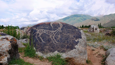
The former Soviet republic of Kyrgyzstan is possessed of a great deal of rock art, especially beautiful petroglyphs of ibex. Kyrgyzstan has been known as a land of mounted nomads for pretty much all of recorded history. Recently I was conducting an online search for public domain photos of Kyrgyzstan rock art. Among the many ibex petroglyphs that came up was the one above which, at first, I could not identify. It took me a couple of minutes to realize what this is. The other main thing that the Kyrgyz people have been known for is falconry, or more specifically hunting with trained eagles. This is a crude petroglyph of a Kyrgy eagle hunter.

“The history of the Kyrgyz people and the land now called Kyrgyzstan goes back more than 3,000 years. Although geographically isolated by its mountainous location, it had an important role as part of the historical Silk Road trade route. In between periods of self-government it was ruled by Gokturks, the Uyghur Empire, and the Khitan people, before being conquered by the Mongols in the 13th century; subsequently it regained independence but was invaded by Kalmyks, Manchus and Uzbeks. In 1876 it became part of the Russian Empire, remaining in the USSR as the Kirghiz Soviet Socialist Republic after the Russian Revolution. Following Mikhael Gorbachev’s democratic reforms in the USSR, in 1990 pro-independence candidate Askar Akayev was elected president of the SSR. On 31 August 1991, Kyrgyzstan declared independence from Moscow, and a democratic government was subsequently established.” (Wikipedia)

“Hunting with the golden eagle is an ancient tradition that dates back to the Mongol conquest of Central Asia around the 12th and 13th centuries, when a fine eagle and a good horse cost the same price and both lent prestige to their owner. Although the practice is gradually disappearing in this area, hunting with birds (especially with eagles) is still practiced in certain regions of Kyrgyzstan and Kazakhstan. Westerners tend to think of this as falconry – and although hunting with hawks and falcons does take place, it is looked down upon by those who hunt with eagles as a pastime for children and dilettantes.” (Advantour) Far from originating in the 12th and 13th centuries as stated above, a burial from Subeshi, near Turfan, of a woman eagle hunter (see below) has been dated to mid-1st millennium B.C. (Barber 1999:199)
“For thousands of years, golden eagles have been the favorite raptor to train as a hunting companion across the northern steppes from the Caucasus to China. Eagles are strong predators especially adapted to winter hunting for hare, marmot, wild goat, deer, fox (even lynx, pallas cat, and wolf, although these are unnatural prey and dangerous for the eagles). Eagles have very acute eyesight for spotting prey in snow-covered grasslands and mountains. The eagles weigh up to 12 pounds and have an extremely strong grip with sharp talons. To support the eagle on a rider’s arm, a baldak, a Y-shaped wooden rest, is attached to the saddle. Female eagles, larger, fiercer, and more powerful than males, are preferred as hunting companions by Kazakhs; Kyrgyz eagle hunters train both females and males. Several types of eagles are recognized with different abilities. Fledglings or sub-adult eagles are captured from the nest and trained to hunt. According to tradition, after 5-7 years the eagles are released back to the wild to mate and raise young. Evidence pointing to eagle hunting’s antiquity comes from Scythian and other burial mounds of nomads who roamed the steppes 3,000 years ago and whose artifacts abound in eagle imagery. An ancient Scythian nomad skeleton buried with an eagle was reportedly excavated near Aktobe Gorge, Kazakhstan. Ancient petroglyphs in the Altai region depict eagle hunters and inscribed Chinese stone reliefs show eagles perched on the arms of hunters in tunics, trousers, and boots, identified as northern nomads (1st to 2nd century AD).” (Mayor 2016:3)

The second petroglyph shows a mounted hunter with his dog and his eagle. This photograph was brought to my attention by Adrienne Mayor and was found on a website by Stephen Bodio, a writer and traveler. The photograph was taken by Andrey Kovalenko and was located near Golpaygan, Isfahan, in the central part of Iran.

Like the other mounted nomadic hunters of that region, a Kyrgy hunter needed a good horse, his trained eagle, and one of the local breed of hunting dogs, the taigan. A man who had all three was thought of as successful, even prosperous.


A final
pair of illustrations shows the mummified body of an Eagle Hunter (Huntress). “From its graves the Urumchi archaeologists
pulled several colorfully arrayed bodies. One woman (fig. 10.3) wore a copious
woolen skirt striped horizontally in shades of red, yellow, and brown, with a
dark felt hat rising high above her to two conical peaks like a twin-steepled
church. The pelt used to make her long coat had the turned inward for warmth,
and neat leather slippers protected her feet. A gigantic leather mitten encased
her left hand, the sort of protection a falcon owner might wear, and she
possessed two little pouches, one the shape of a long, narrow chili pepper and
the other containing a round-topped comb.” (Barber 1999:198-9)
Now we not only have rock art illustrating this practice, we have archaeological evidence from a burial from Subeshi, near Turfan, of a woman eagle hunter that has been dated to mid-1st millennium B.C. (Barber 1999:199) Subeshi is a lost city located near Kucha in the Taklamakan Desert in China’s Tarim Basin on the ancient silk road. A long and honorable tradition among the steppe people living in this large region.
NOTE
1: Some images in this posting were retrieved from the internet with a search
for public domain photographs. If any of these images are not intended to be
public domain, I apologize, and will happily provide the picture credits if the
owner will contact me with them. For further information on these reports you
should read the original reports at the sites listed below.
NOTE 2: How the MacArthur Foundation has gone on so long without giving Adrienne Mayor one of their “genius” grants is totally inexplicable.
REFERENCES:
Advantour, Hunting with Eagles in Kyrgyzstan, https://www.advantour.com/kyrgyzstan/cultuure/hunting-eagles.htm, accessed 7 November 2021
Barber, Elizabeth Wayland, 1999, The Mummies of Urumchi, W. W. Norton and Company, New York.
Bodio, Stephen, 2013, “New” Petroglyph, 2 January 2013, stephenbodio.com
Mayor, Adrienne, 2016, The Eagle Huntress, Ancient Traditions and New Generations, 1 May
2016, mayor@stanford.edu