Showing posts with label Wyoming. Show all posts

Saturday, February 4, 2023

12,000 YEAR OLD ROCK ART DATES IN NORTH AMERICA:

Team member taking a pXRF reading at Rochester Creek site, Utah.

The perennial problem of dating petroglyphs may have finally been solved. A team from the Max Planck Institute has used portable X-ray fluorescence equipment (pXRF) to measure levels of elements in the patina in petroglyphs and comparing that to the levels of the same elements in the rock varnish on the unpecked surfaces have come up with seemingly accurate and reliable age estimates for four sites in the northeastern Great Basin of North America. 

Legend Rock site, near Thermopolis, Wyoming.

"Researchers at the Max Planck Institute for Chemistry have now succeeded in applying their non-destructive method to dating rock art in North America. The analysis shows that rock art in the Great Basin, a region in the western U.S., was produced and continuously renewed for twelve millennia. Indigenous people accessed the same artworks over and over again and endowed them with new meaning, the findings show." (Max Planck Institute 2022)

Map Rock Site, Snake River valley, Idaho.

"Rock art originated some 46,000 years ago and can provide unique insights into the minds of our human ancestors. However, dating of these ancient images, especially of petroglyphs, remains a challenge. In this study, we explore the potential of deriving age estimates from measurements of the areal densities of manganese (Dmn) and iron (Dfe) in the rock varnish on pertoglyphs, based on the concept that the amount of varnish that has regrown on a petroglyph since its creation, relative to the surrounding intact varnish, is a measure of its age. We measured (Dmn) and (Dfe) by portable X-ray fluoresence (pXRF) on dated Late Pleistocene and Holocene rock surfaces, from which we derived accumulation rate of Mn and Fe in the rock varnish. The observed rates were comparable to our previous findings on basalt surfaces in North America. We derived age estimates for the rock art at four sites in the northern Great Basin region of North America based on Dmn measurements on the petroglyphs and intact varnish. They suggest that rock art creation in this region began around the Pleistocene/Holocene transition and continued into the Historic Period, encomassing a wide range of styles and motifs. Evidence of reworking of the rock art at various times by indigenous people speaks of the continued agency of these images through the millennia. Our results are in good agreement with chronologies based on archeological and other archaeometric techniques. While our method remains subject to significant uncertainty with regard to the absolute age of individual images, it provides the unique opportunity to obtain age estimates for large ensembles of images without the need for destructive sampling." (Andreae and Andreae 2022)

Celebration Park site, Idaho.

"In the present study, we conducted in-situ measurements by pXRF on petroglyphs at four sites in Idaho, Wyoming, and Montana to determine the areal densities of Mn and Fe in the varnish that had re-accumulated on the rock since its creation. We also made measurements on the intact varnish surrounding the rock (art) to assess the variability of varnish foration between different rock surfaces. We complimented these data by measuring the Mn and Fe densities on rock surfaces of known geological age to obtain varnish accumulation rates. From these results, we derived age estimates for the petroglyphs and evaluate tham within their archaeological and cultural context. Our study extends significantly the very scarce knowledge base on the rate of rock varnish accumulation in semiarid to mesic regions, provides further validation of non-destructive dating technique for rock art, and elucidates the history of rock art creation at four important archaeological sites representing the Great Basin Macrotradition." (Andreae and Andreae 2022)

Celebration Park site, Idaho.

The four sites tested by the Andreaes are; Celebration Park and Map Rock, two petroglyph sites in the Snake River Valley between Twin Falls and Marsing, Idaho; Legend Rock, 35 km northwest of Thermopolis, Wyoming; and Petroglyph Canyon, 21 km northwest of Lovell, Wyoming, just north of the Montana state line. (Andreae and Andreae 2022)

Celebration Park site, Idaho.

Sites were chosen that had age estimates assigned previously by other methods to allow the team to cross-check their results against previous age estimates. "The diverse rock art spans a broad time period, from the Paleo-Indian era about 15,000 years ago to the recent past. Moreover, the scientists were able to complement their own method with measurements of rock engravings whose ages had previously been dated using independent geochemical methods. Both age estimates were in excellent agreement and thus confirmed each other. The comparison with other archaeological material at the rock art sites, which had been previously dated, also supported the researchers' age estimates." (Max-Planck-Gesellschaft 2022) 


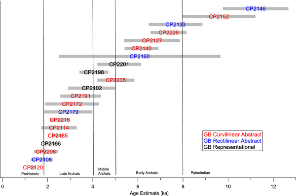
Graph of testing results from Celebration Park site, Idaho.

"'All of our analyses suggest that the earliest petroglyphs were created as early as the transition period from the Pleistocene to the Holocene, about 12,000 years ago, and were repeatedly revised by indigenous people over thousands of years until the recent past,' explains Andreae, a biogeochemist." (Max-Planck-Gesellschaft 2022)

Celebration Park site, Idaho.

If these results hold up through further testing it may be that we have finally achieved at least this one holy grail of rock art research - the ability to date petroglyphs through clues in the patination coating them. Back in the early 80s I made some unsuccessful attempts to do this using a photographic light meter to determine relative darkness of the patina in and ourside of a petroglyph. At roughly the same time Dr. Ronald Dorn was analyzing cation ratios in the varnish to determine the age of petroglyphs, and at that time his method also was not widely trusted and adopted, although I know of instances where his readings successfully matched age estimates for petroglyphs made using other methods. But now we may finally have an inarguable success in dating petroglyphs, and I congratulate the Andreaes' and look forward to their further developments.

NOTE: Some images in this posting were retrieved from the internet with a search for public domain photographs. If any of these images are not intended to be public domain, I apologize, and will happily provide the picture credits if the owner will contact me with them. For further information on these reports you should read the original reports at the sites listed below.  

REFERENCES:

Andreae, Meinrat O., and Tracy W. Andreae, 2022, Archaeometric studies on rock art at four sites in the northeastern Great Basin of North America, 26 January 2022, PLOS, https://doi.org/10.137/journal.pone.0263189. Accessed online 18 August 2022.

Max-Planck-Gesellschaft (Institute), 2022, 12,000-kyear-old rock art in North America, non-destructive method dating petroglyphs in the American West, 28 January 2022, https://mpg.de/18213975/rock-art-petroglyph-dating. Accessed online 17 August 2022.  


Friday, May 6, 2022

DID WE SEE A BLACK-FOOTED FERRET AT CASTLE GARDENS, WYOMING?


Castle Gardens, Wyoming.


Location of Castle Gardens, Wyoming.

In September 1992 a group from the Colorado Archaeological Society was visiting the wonderful rock art site of Castle Gardens, Wyoming. At one point while looking at a petroglyph panel two or three of us saw a movement out of the corner of our eye, low down on the ground and to the left, which drew our attention. Looking that way we saw just a flash of a small, low (short-legged), long-bodied animal run behind a rock formation. None of us got a good enough look to see details, but, having seen weasels before my first and immediate impression was that it was a member of that family (Mustelidae). Its color was a light tan, not the darker brown of a mink or a weasel. It was also not the white of a short-tailed weasel or ermine in winter colorization (as this was September they would have still been wearing their summer coat of white neck, chest, and underbelly, and medium to dark brown elsewhere). This was definitely a light tan color.


Black-footed ferret. Internet photograph, public domain.

“The ferret was first described by John James Audubon and John Bachman in 1851 from a single specimen collected from Goshen County, Wyoming. By the mid 1900s, historical eradication campaigns, diseases, and habitat loss through cropland conversion had drastically reduced populations of prairie dogs, the primary prey species for ferrets. As prairie dogs declined, ferrets were predicted to be near extinction. In 1967, the ferret was federally listed as Endangered throughout its range in Wyoming and 11 other western and Midwestern states under the Endangered Species Act. Within 1 year of this designation, all wild ferrets from the last known population in Mellette County, South Dakota died, and by 1979 the last ferret in captivity also perished. Despite nearly a decade (1973-1981) of targeted searches throughout Wyoming and adjacent states, no other populations were found, leading many to believe that the ferret was extinct.

In 1981, a fortuitous event occurred that irrefutably saved the ferret from extinction and initiated one of the most successful wildlife conservation stories in history. On 26 September 1981, a rancher’s cattle dog brought the carcass of a weasel-like animal to the doorstep. A local taxidermist identified the species as a ferret, and soon thereafter biologists discovered a population of ferrets in the surrounding area.” (Wyoming Black-Footed Ferret Management Plan 2018:2-3)

With the rediscovery of this remaining wild population a captive-breeding program was undertaken to save the species. “A captive-breeding program launched by the United States Fish and Wildlife Service resulted in its reintroduction into eight western US states, Canada, and Mexico from 1991 to 2009.” (Wikipedia)

“In 1991, the first reintroduction site for ferrets was established at the Shirley Basin/Medicine Bow Reintroduction Site.” (Wyoming Black-Footed Ferret Management Plan 2018:4)  It seems highly unlikely that a ferret reintroduced to the wild in 1991 at the Shirley Basin/Medicine Bow Site would have appeared at Castle Gardens in September 1992 with a distance of over one hundred miles between them, so our assumption is that there were, in fact, other wild ferrets that had remained undiscovered.

“As of 2011, over 1,000 mature, wild-born individuals are in the wild across 18 populations, with four self-sustaining populations in South Dakota, Arizona, and Wyoming.” (Wikipedia) Hopefully, the future of the Black-footed ferret in the wild is now assured.


Shield petroglyph with two long, slender animals. Castle Gardens, Wyoming. Photograph Peter Faris, September 1992.


Close-up of shield petroglyph with two long, slender ferret-like animals. Castle Gardens, Wyoming. Photograph Peter Faris, September 1992.


Another shield petroglyph with two long, slender ferret-like animals. Castle Gardens, Wyoming. Photograph Peter Faris, September 1992.


Close-up of another shield petroglyph with two long, slender ferret-like animals. Castle Gardens, Wyoming. Photograph Peter Faris, September 1992.

Castle Gardens is known for its grand displays of petroglyphs, many of them shield designs. One of these has a head with horns (a horned-headdress?) flanked by two slender, long-bodied animals oriented vertically on each side, and another has two slender, long-bodied animals vertically and opposite each other without the head in between, like mirror images of each other. Without enough details to further identify these animal portrayals, their shape alone makes the possibility that they are meant to portray a weasel or ferret, a real option that must be considered. This suggests that the Ancestral Native peoples here who made the shield petroglyphs must have been familiar with the black-footed ferret, the country is the same as the environment they used to thrive in and the pictures are here.

So, the upshot of this is that we three observers are convinced that in 1992 we saw petroglyphs at Castle Gardens that portray ferrets as designs on shields, as well as seeing a live, wild black-footed ferret at Castle Gardens, a place where, and at a time when, they were supposedly extinct. Quite a memory.

NOTE: Some images in this posting were retrieved from the internet with a search for public domain photographs. If any of these images are not intended to be public domain, I apologize, and will happily provide the picture credits if the owner will contact me with them. For further information on these reports you should read the original reports at the sites listed below.

REFERENCES:

Anonymous, 2018, Wyoming Black-Footed Ferret Management Plan, 24 November 2018, Wyoming Game and Fish Commission and Black-Footed Ferret Working Group, State of Wyoming.

Wikipedia, Black-Footed Ferret, https://en.wikipedia.org/wiki/Black-footed_ferret, accessed on 1 April 2022.

Thursday, April 1, 2021

EXTINCT ANIMALS IN ROCK ART - THE NAUGA:

A group of naugas. Dinwoody style petroglyphs, Fremont County, Wyoming. Photograph Peter Faris, September 1992.

Rock Art researchers have long referred to images of animals in rock art to try to picture what extinct animals might have looked like. Perhaps the best known examples of this are the aurochs and paleolithic horses of Europe so beautifully illustrated in the European painted caves.

Nauga. Internet photograph, Public Domain.

One extinct animal that is frequently found pictured in the Dinwoody style rock art of northwestern Wyoming is the nauga. The facts of the extinction of the nauga are quite mysterious and hard to discern. Based upon their large mouth full of sharp teeth I assume that they were carnivorous and may have almost extinct with the demise of the megafauna at the end of the Pleistocene that they depended on for food. It would appear, however, that a relic population must have survived in northwestern Wyoming because of their appearance in the Dinwoody Style rock art of that region. These must have survived on the bison that were so numerous. This rock art was produced by the Shoshonean residents of that area.


Nauga petroglyphs, Dinwoody style, Legend Rock, Hot Springs County, Wyoming. Photographs Peter Faris, September 1992.

It is well known that the US Government attempted to reduce the free Native American population on the Great plains by encouraging the over-hunting of the bison that they depended on to force them onto designated reservations. The over-hunting of the bison also led to the extinction of the naugas who depended upon them for food, as well as forcing the Native Americans onto reservations.


      Nauga petroglyphs, Dinwoody style,    Torrey Lake Canyon, Fremont County,         Wyoming. Photograph Peter Faris,                           September 1998.

The US Government has tried to cover up this shocking genocide by promulgating this phony cover story. “Naugahyde is an American brand of artificial leather. Naugahyde is a composite knit fabric backing and expanded polyvinyl chloride (PVC) plastic coating. It was developed by Byron A. Hunter, senior chemist at the United States Rubber Company, and is now manufactured and sold by the corporate spin-off Uniroyal Engineered Products, LLC. Its name, first used as a trademark in 1936, comes from the name of Naugatuck, Connecticut, where it was first produced. It is now manufactured in Stoughton, Wisconsin.” (Wikipedia)

But who knows what might still be found in the backcountry of Yellowstone. I urge cryptozoologists and other interested parties to conduct a detailed survey of the remaining wildlife in Yellowstone National Park. The much mistreated nauga might just be still there, holding on to life - I would suggest starting as soon after April 1 as possible.

NOTE: An image in this posting was retrieved from the internet with a search for public domain photographs. If any of this image is not intended to be public domain, I apologize, and will happily provide the picture credits if the owner will contact me with them. For further information on this reports you should read the original report at the site listed below.

REFERENCE:

Wikipedia, Naugahyde, https://en.wikipedia.org/wiki/Naugahyde

Saturday, May 28, 2016

SEEKING BEAR, A BOOK REVIEW:


 Cover.

I want to introduce you to another wonderful book by Jim Keyser and George Poetschat, Seeking Bear: The Petroglyphs of Lucerne Valley, Wyoming, 236 pages. Published in 2015 by the Oregon Archaeological Society Press, Portland, with well over 100 illustrations and tables it is another in their series of in-depth studies of rock art of the northern Great Plains and Basin. The Lucerne Valley, Wyoming, is an area in southwest Wyoming that has not been studied extensively in the past, so this volume greatly expands knowledge of rock art of that part of Wyoming and the adjacent areas of Colorado and Utah.

Title page.

Among these contributions to rock art knowledge are documenting the presence of rock art styles in the Lucerne Valley which are known from other areas, expanding the knowledge (at least my personal knowledge) of them and enlarging the region that they are pertinent to.  The first of these is the Classic Vernal Style of Fremont rock art which is found so magnificently around Vernal, Utah, and the Dinosaur National Monument. I had not known of any examples of that style of petroglyph farther north than Brown's Park, Colorado (although it is close enough to be expected). Also images in the Lucerne Valley were documented that the authors attribute to the Uncompaghre Style of rock art, named for examples around the Uncompaghre Plateau, south of Grand Junction, Colorado.  Also the authors explain one image in terms of the meaning of elements of the Dinwoody Style of petroglyph found in the Wind River Valley farther north in Wyoming. These examples of relating images to styles from other locations illustrates that the people of the Lucerne Valley were tied in to the cultures of their larger world, whereas we have tended to overlook that area as an isolated border region between other populations (once again affirming that it is dangerous to use our modern assumptions in evaluating past cultures).

In analyzing the images illustrated in the rock art panels, Keyser once again illustrates his amazing ability to see fine detail and to recognize elements overlooked by other people. This book provides many succinct demonstrations of how much can be learned by really detailed examinations of rock art. One example is a listing of six animals at one site and noting the position of the tail of each animal. Elsewhere the shapes of antlers on cervids are also compared.

One of the high points to me in reading this book is the authors' ability to explain many of the concepts that we often feel strongly about but have not reasoned through. On page 148, a discussion of rock art symbols and their meanings provides a masterful summation of many of the various popular and New Age explanations of rock art that frustrate so many real students of the subject. Also, on page 186, their detailed presentation on the perennial idea that rock art represents "hunting magic" could be used in any college anthropology class on the subject. 
Five stars for excellence.

All-in-all, Seeking Bear, is a highly detailed, relentlessly educational presentation of the rock art from a little known area which ties it inexorably into the larger whole world around it. My only (and I emphasize only) criticism of this wonderful volume is its lack of an index. For someone like me, who enjoys pursuing a train of thought, idea, or insight, through a volume by referring to the index this was a frustrating absence. I actually had to read it through from beginning to end, and perhaps this was their intention all along. Watch out -you just might learn something. Once again, my gratitude to Jim Keyser and George Poetschat for this contribution to rock art studies and literature. Thank you.


Keyser, James D. and George Poetschat,
2015    Seeking Bear: The Petroglyphs of Lucerne Valley, Wyoming, Oregon Archaeological Society Press, Portland. www.oregonarchaeological.org.

Friday, December 11, 2015

HISTORIC INSCRIPTIONS - TOM HORN, 1894:


Tom Horn, 1894, inscription. South-central
Montana. Photograph by Timothy Urbaniak,
used by permission.

Periodically, I include historic inscriptions in RockArtBlog, not that they are art per se, but because they provide a direct link to the history of the Western US. This week I am illustrating the inscription pictured above, Tom Horn, 1894.

"Thomas "Tom" Horn, Jr. (November 21,1860 - November 20, 1903) was an American Old West scout, who carried out varied roles as hired gunman, Pinkerton range detective, cowboy, and soldier." (Wikipedia)

Tom Horn, photograph from internet.

"At Names Hill in western Wyoming, local ranchers continued to participate in the cultural tradition of inscribing at that site. During that time there (were) new threats coming to the cattle ranches across the Northern Plains in the form of rustlers. As part of an effort to control rustling, Wyoming ranchers from around Cheyenne hired Tom Horn as an enforcer. In 1894 he was brought in as a detective by the Swan Land & Cattle Company of Cheyenne. Reputed as a cold-blooded killer that liked to shoot from afar, the placement of an inscription reading "Tom Horn, 1894" (Figure 5.68) is placed high along sandstone rimrocks. An interesting note about the inscription site is that it is placed on a cliff at the top of a valley between Billings and Hardin, Montana, with an excellent vantage spot of the travel corridor, and a place in a break in the sandstone cliffs large enough to contain a horse and bedroll." (Urbaniak 2014:128)


"Believed to have committed 17 murders as a hured gunman in the West, in 1902 Horn was convicted of the murder of 14-year-old Willie Nickell near Iron Mountain, Wyoming. The boy was the son of sheep rancher Kels Nickell, who had been involved in a range feud with neighbor and cattle rancher Jim Miller. On the day before his 43rd birthday, Horn was executed by hanging in Cheyenne Wyoming.
While in jail he wrote his autobiography, Life of Tom Horn: Government Scout and Interpreter (1904), which was published posthumously. Numerous editions have been published of this book since the late 20th century, and debate continues as to whether he was guilty of Nickell's murder." (Wikipedia)

Tom Horn presents us with an interesting and controversial case because, as noted above, historians of he are still argue over his guilt or innocence in that particular murder. Horn had reportedly confessed to it while drunk but the circumstances throw enough doubt on the case to keep the question open. Not that Horn did not deserve hanging. His career of murder as a hired gun certainly qualified him for capital punishment. Reportedly, when asked if he had any last request before his 1903 hanging Horn asked to have a friend of his in another cell sing him the song "Life's Railway to Heaven" or "Life is Like a Mountain Railway." This is also one of my favorite hymns.
.  .  .  .  .  .  .  .  .  .  .  .  .  . 

NOTE: Presented through the generosity of Tim Urbaniak, who compiled this material for his 2014 PhD thesis, HISTORIC INSCRIPTIONS OF THE NORTHERN PLAINS IDENTITY AND INFLUENCE IN THE RESIDUAL COMMUNICATION RECORD at the University of Montana, in Missoula.

REFERENCES:

Urbianik, Timothy Rostov,
2014    HISTORIC INSCRIPTIONS OF THE NORTHERN PLAINS IDENTITY AND INFLUENCE IN THE RESIDUAL COMMUNICATION, Dissertation Presented in partial fulfillment of the requirements for the degree of Doctor of Philosophy in Anthropology The University of Montana Missoula, MT,  July 2014.

Wikipedia.

Friday, May 9, 2014

WHERE BARRY FELL – CASTLE GARDENS, WYOMING #2:


Castle Gardens, Fremont County, WY.
Photograph Peter Faris, Sept. 1992.

On September 14, 2013, I posted a column entitled Where Barry Fell – Castle Gardens, Wyoming, that discussed Fell’s discovery and documentation of the First Iberian Bank of Moneta, Wyoming, based upon petroglyphs that he deciphered. For Fell the presence of ancient Celts was confirmed by the presence of the petroglyphs illustrated below. The first illustration is found at Castle Gardens and the second comes from near Writing-On-Stone, Alberta, Canada.


"Lug, the Celtic God of Light", Fig. 7-1, 
Barry Fell, Bronze Age America, p. 155.

“Chief of the Celtic gods was Lug, god of the sky and of light, and creator of the universe. His emblems are his spear and his sling-shot. With the latter he once destroyed a one-eyed monster named Balar, who, with his sorcerer attendants the Fir-bolg, had gained the mastery of Ireland. Balar is depicted in an unlettered inscription on the Milk River, near Writing-on-stone, Alberta. He is shown as having one leg and one arm, held aloft over his gigantic eye, which could kill hundreds merely by its glance. In this pictograph, Figure 7-2, Lug has just loosed the thong of his slingshot and the monster is about to bite the dust. Another and evidently much later depiction of Lug is that in Figure 7-1, where his name is given in Norse runes, one of many examples we now have of Norse influence on the western Celts in North America. Presumably the Norsemen came down from Hudson Bay to enter the prairie lands. In this petroglyph Lug is shown holding his magic spear, by means of which he defeats the forces of darkness each year, to usher in the returning spring. The last mentioned petroglyph occurs on cliffs at Castle Gardens in Wyoming, and at the same site another Celtic god is identified by his name written in Norse runes. This is Mabona (or Mabo), the Celtic Apollo, god of music and of sports and the presiding divinity in charge of male fertility. In this context his symbol is the phallus, shown in the petroglyph on the rock above him.” (Fell 1982:154)

“Figure 7-1. Lug, the Celtic god of light, is here identified in Norse runes of the period A.C. 750-1050. The name is in the possessive case: Lug’s (site or his image). This remarkable petroglyph occurs at Castle Gardens near Moneta, in Wyoming, and the drawing is traced from a photograph taken by Ted C. Sowers of the Wyoming Archaeological Survey (1941). Although this is the work of an artist of relatively modern times, the theme harks back to the Bronze Age, as does the formalistic style, like that of the earliest Bronze Age.” (Fell 1982:155)


Close-up, Castle Gardens, Fremont County, WY.
Photograph Peter Faris, Sept. 1992.

As can be clearly seen below the figure in the photograph there are a large number of linear markings of various ages (including a historic addition in English) superimposed, and it would not seem to be much trouble to find any rune or letter you wished by careful selection of the right lines. Indeed, in his figure 7-1, Fell’s last two letters can be seen in the close-up to consist of the disassembled neck and torso of a “V-Necked Anthropomorph” figure from a prehistoric petroglyph. The proper question here is not what was found by careful selection (and a lot of imagination) on the rock, but instead what was overlooked because it did not fit with preconceptions intent on finding that message.


"Lug, God of Light", Fig. 7-2, Barry Fell, 
Bronze Age America, 1982, p.158.

“Figure 7-2. Lug, god of light (right), prepares to fire his slingshot at the giant (closed) eye of the one-legged monster, Balar, who is attended by one of the Fir-bolg. Alberta Provincial Park.” (Fell 1982:158)

I don't even know how to address the nonsense of Fell's figure 7-2. He sees a Celtic god armed with a sling where I see a Native American warrior armed with a bow and arrow. Then he sees on the left the giant closed eye of a one-legged monster named "Balar, who is attended by one of the Fir-Bolg." (Fell 1982:158) Here I see another Native American warrior who is holding a shield to defend himself from the arrows of the first warrior.

If we rationalize hard enough we can imagine almost anything - but that does not make it true. As I have said before, falsification and prevarication are never acceptable.

REFERENCE:

Fell, Barry
1982    Bronze Age America, Little, Brown and Company, Boston.

Saturday, November 9, 2013

DEVIL’S TOWER, WYOMING:


Bear's Lodge Butte (Devil's Tower), Wyoming.
Photograph: Peter Faris, June 2013.

High on every list of sites that are sacred to Native Americans is Bear Lodge Butte, listed on our maps and in our records as Devil’s Tower. I can remember being fascinated with this pretty much all of my life after seeing a picture of it in a Little Golden Guide to Geology as a child.


Bear's Lodge Butte (Devil's Tower), Wyoming.
Photograph: Peter Faris, June 2013

In his book Where Lightning Strikes: The Lives of American Indian Sacred Places, Peter Nabokov gave a description of the beliefs and mythology that are attached to this location by Native Americans. “Best known of the Black Hills outliers was what Indians called Bear Lodge Butte, but which whites in offensive contrast to its heroic role in Indian mythology, came to name “Devil’s Tower.” Remembered by most Americans, this volcanic upthrust, located to the north of the Hills that jutted into the sky like a great horn with its tip lopped off, was the Mother Ship’s landing pad in director Steven Spielberg’s 1977 science fiction classic Close Encounters of the Third Kind. But to the Kiowa tribe the 867-foot promontory was revered as T’sou’a’e, or “Aloft on a Rock.” Here was the embarkation point for that early period in Kiowa Indian history that the Pulitzer Prize-winning novelist N. Scott Momaday called “the setting out.” From these high plains their ancestors migrated south, to ultimately reach the area of Rainy Mountain in western Oklahoma, where their reservation is found today.
Like a number of Plains Indian tribes, the Kiowa never forgot the Tower’s place in their mythology. They told of the seven sisters and a brother who were playing together. Transformed into a monster bear, the brother attacked his sisters, who ran for their lives. When they reached a giant tree stump it told them “climb up on me.” Once they were on top the stump began to grow, leaving the bear pawing at them and raking its sides with his claws – those vertical grooves remain to this day. On the summit the girls were finally safe, but the Kiowa say the sisters then ascended into the sky, to become the constellation we know as the Big Dipper (other tribal versions say the Pleiades).” (Nabokov 2006:215-16)
  
We finally undertook the trip there in June 2013. A long day’s drive got us to Sundance, Wyoming, which serves as the gateway to the Devil’s Tower National Monument. In Sundance we had a nice motel room at a reasonable price, and ate fine meals in a couple of good restaurants. The next day we drove out to the tower itself. It was every bit as impressive as I had hoped. We hiked around the spire and saw probably a couple of dozen rock climbers working their way up various routes. I could certainly get a small sense of the unease that Native American peoples feel to a greater extent seeing these people climbing up this sacred rock.


Offerings at Bear's Lodge Butte (Devil's Tower),
Wyoming. Photograph: Peter Faris, June 2013.

While walking around the vicinity of the rock many small offerings could be seen in the trees in various locations around the tower reinforcing its spiritual nature for some people. I am pleased to be able to report that there does not seem to be any meddling with these offerings, such as collecting or removing them. 

As we might imagine for a site with such spiritual significance there is rock art in the area although the park personnel greet such inquiries with an assumed air of ignorance. In her interesting book Storied Stone: Indian Rock Art in the Black Hills Country, Linea Sundstrom has illustrated petroglyphs at a site designated 48CK1544, which is located within view of the tower.


Left side of main panel, Site 48CK1544, 
Sundstrom, Fig 12.4, p. 146.


Right side of main panel, 48CK1544,
Sundstrom, Fig. 12.4, p.147


Incised face and design, 48CK1544,
Sundstrom, Fig. 12.6, p.147.

Sundstrom wrote about the rock art near Devil's Tower "petroglyphs located upon a ridge within distant view of Devil's Tower reflect a link between landscape and rock art. Although they are part of the incised rock art tradition, these petroglyphs are unlike others in the area. Some of the rock art represents thunder beings - eagle- or hawklike creatures with outspread wings (fig. 12.4). One petroglyph shows a creature with some human and some thunderbird characteristics. Perhaps these record the trance of some vision seeker."

For more about the rock art near Devil's Tower and, indeed, for rock art throughout the Black Hills region read Linea Sundstrom's writings. And, for a great trip to a beautiful area, and a moving experience, I highly recommend a visit to Bear's Lodge Butte/Devil's Tower.

REFERENCE:

Nabokov, Peter
2006    Where Lightning Strikes: The Lives of American Indian Sacred
 Places, Peter Nabokov, Viking Press, New York.

Sundstrom, Linea
2004     Storied Stone: Indian Rock Art of the Black Hills Country, 
           University of Oklahoma Press, Norman.

Saturday, September 14, 2013

WHERE BARRY FELL – CASTLE GARDEN, WYOMING:


Castle Gardens, Wyoming.

Continuing to kick poor old Barry Fell around, we now come to what I feel may be the most egregious example of falsification and fabrication in his whole repertoire. In central Wyoming a concentration of petroglyphs is found at Castle Gardens near the small town of Moneta. The Plains Indian petroglyphs here show a major concentration of shield images.


Castle Gardens, Wyoming.

Fell however, cannot let these marvelous images of Native American heraldry just be what they are. He has to warp them into a fantastic story of Celtic/Roman/Iberian travelers and traders who voyaged to Wyoming to open a branch of the First Iberian Bank of Moneta. I will be presenting this story mostly in his own words with comments thrown in as seems appropriate. Notice that the petroglyph panel showing the grouping of shields has a lot of plaster stuck on it from attempts to make molds of the images. I would not personally be surprised to find out that this was the result of Fell’s operations since we have already seen in so many examples that he works mostly from reproductions made from molds cast from the original rock art.

“Petroglyphs representing ancient coins extend the range to the ancient equivalent of the Oregon Trail, extending across the prairies to Moneta in Wyoming. The latter town appears to mark the site of the annual fur market in Roman times, lying near the North Pass in the Great Divide, and thus as convenient for ancient trappers as the nineteenth-century Wyoming markets were for trappers and buyers of the Astor company. The route also gave access to Nevada and California silver.“ (Fell 1980:35)

“There is one more site: the great pictograph and petroglyph location called Castle Gardens, near the town of Moneta, in central Wyoming. Dr. Don Rickey, chief historian of the Bureau of Land Management, Department of the Interior, was one of my first visitors a few days after America B.C. was published at the end of 1976. He had been struck by many features of the book that appeared to throw possible light on problems of American epigraphy and early history.  -  He began by referring to me various reports in the files of the Bureau of Land Management dealing with unexplained petroglyphs. One of the reports dealt with the Wyoming site mentioned above – the finest petroglyph location in Wyoming, remarkable for the almost universal circular form of all the designs depicted on a series of rock faces that dominate the site.
            Some of the designs I recognized at sight as well-known Celtic patterns, used on disc-shaped bronze harness trappings of Celtic kings in Europe, and also occurring in the Spiro Mound in Oklahoma, together with other evidences of Celtic designs. But the great majority of circular patterns cut into the cliffs at Castle Gardens were not familiar to me when I first saw them. They seemed so dissimilar to Indian shield patterns that it was hard to relate them to these either.” (Fell 1980:134-5) 

“The final solution to the Castle Gardens mystery came like this:
            After the match between the Byzantine bronze-coin series and the supposed “Indian shield” series of Colorado petroglyphs was discovered, I remembered the mysterious suite of circular “shield” patterns from the Wyoming site, and once more got out Dr. Rickey’s report -. This time I did indeed begin to recognize, one by one, designs that resembled ancient coins I had once seen.”(Fell 1980:140)

"Italian chariot wheel coin design and supposed imitation
at Castle Gardens. Barry Fell, Saga America, p.152.

“Bewilderment was the Wyoming artist’s reaction to certain themes featured on the Romano-Iberian coinage. In B, the crab of the Roman model A, unknown in mid-continent is rendered as an obese person executing a handstand. In D, a half-chariot becomes a mysterious sun god; for where no horses exist, there can be no wheeled vehicles. In F, the Old World cock of an Italian bronze piece becomes a turkey, experiencing great difficulty in fitting its ample proportions into the confines of a circular flan. In H an Italian chariot wheel becomes a cross-pattee. All designs on the right side are petroglyphs from the Moneta site of the Wyoming Iberian bank. Those on the left side are drawn from Roman Republican and Campanian coins; Iberian examples are commonly bisected to yield lesser denominations, or “bits,” as shown at C.” (Fell 1980:152)

I believe that the image of the supposed imitation "Italian chariot wheel coin" corresponds to the shield figure found in the illustrations below. According to James Keyser this image is not even from Castle Gardens, Wyoming. He identified it as being found near Sheriden, Wyoming. Although a little hard to make out in the actual photo you can identify the form of the shield easily in the drawing that I made from an illustration in James Keyser and Keyser and Michael A. Klassen's 2001 book, Plains Indian Rock Art.


Shield figures, Wyoming. The shield of
the figure on the right corresponds to Fell's "H" above.


Comparing Fell’s coin with a cross-pattee to the original rock art photo exposes just how egregious the falsehood and deception is. The original is a shield figure (on the right of the grouping above) and Fell omitted the legs, head, spear, and many details of the shield itself including the fringe of feathers around it (not to mention the whole of the rest of the group of figures), to make it fit his strange idea of it representing a coin from the First Iberian Bank of Moneta, Wyoming.
Shield figure panel, drawn by 
Peter Faris after Keyser and Klassen, p. 197.

But Fell goes further, he not only has identified all the circular shields at Castle Gardens (and throughout the rest of western North America) as coins, he has also discovered the sign of the bank that handled those coins, a supposed inscription in Iberian-Greek. 


Castle Gardens translation, Barry Fell,
Saga America, 1980, p. 149.

“The business sign or tile engraved at the Wyoming site near Moneta. On the left the Iberic letters spell the old Gaelic word for moneychanger, or, in modern parlance bank. On the right, the word intended apparently is Old Gaelic for no interest – or perhaps, rather, no usury (i.e., not more than 12-1/2%). In the center Greek letters phi, alpha, theta, and eta form a rebus in which a moneybag discharges coins onto a dish. The word spelled means “[it was] the first to come here,” resembling the modern use of the word “First” in bank names.” (Fell 1980:149) In other words Fell is stating that this is the sign that identifies the First Iberian Bank of Moneta (the underline is mine).

Maybe Barry Fell for this, but we don’t have to.

REFERENCES:

Fell, Barry
1980    Saga America, Times Books, New York.

Keyser, James D. and Michael A. Klassen
2001    Plains Indian Rock Art, University of Washington Press, Seattle.