Showing posts with label Massachusetts. Show all posts

Saturday, July 21, 2018

ANOTHER SUPPOSED NORTH AMERICAN RUNE STONE:


Noman's Land Island Rune
Stone, Massachusetts.

Every so often, here in North America, we run into an inscription on a stone that is claimed to be done in authentic Viking runes and proves that they were here hundreds of years before the discovery of the Americas by Columbus. The most famous of these, of course, is the Kensington Rune Stone. This column is about a stone on an island off of Martha's Vineyard, the Noman's Land Rune Stone.


Noman's Land Island, off southern
tip of Martha's Vineyard,
Massachusetts.
Image: Google Earth.

The small, uninhabited island called Noman's Land is about three miles off of the southwest corner of Martha's Vineyard. It was previously owned by the U.S. Navy which used it for a bombing range (unexploded ordnance is believed to remain there). It has been owned by the U.S. Fish and Wildlife Service since 1975, and is now used as a wildlife refuge, primarily for migratory birds. (Hickey 2007)

"In 1602, during the British ship Concord's exploration of Cape Cod, Captain Bartholomew Gosnold named Nomans Land "Martha's Vineyard" after his eldest daughter, Martha. However, the name was later transferred to the larger island currently known as Martha's Vinyard, which is located northeast of Nomans Land. The island was probably named "Nomans Land" after a Martha's Vineyard Wampanoag sachem, Tequenoman, who had jurisdiction over the island when the English came in the early 17th century: named from TequeNoman's Land." (Wikipedia)

The stone is reportedly located a little way off of the beach of the island and is usually obscured by water but is apparently exposed at low tide.


Closeup of the inscription,
Noman's Land Island Rune
Stone, Massachusetts.

"Joshua Crane, the former owner of Noman's Land, first discovered the strange lettering on the large black rock late one afternoon when the setting sun sank low on the horizon on afternoon in 1926. Mr. Crane took the oldest known photographs of the inscription in 1926, which were published in a book by Edward Gray titled Leif Eriksson, Discoverer of America." (Hickey 2007)

Gray "sent his photos to some experts at Oslo University. What the professors came back with was certainly interesting - and had the potential to throw three centuries of accepted history on its head. Once deciphered the text read, "Liif Iriksson, MI." (Berke 2015) In this text, the MI is taken to be the Roman numerals for 1001 (the supposed year of the inscription). This mixing of runes and Latin script was known in Britain after AD 700 (where Anglo-Saxon runes and Latin numerals were sometimes used together). "The characters were generally replaced by the Latin alphabet as the cultures that had used runes underwent Christianization, by approximately 700 AD in central Europe and 1100 AD in northern Europe." (Wikipedia) This suggests that it would be contradictory for an authentic Northman's Viking inscription from the year 1001 to contain a Latin notation, and since none of the records seem to suggest that Leif Ericsson's expedition included Anglo-Saxons, that would seem to settle it.

"The stone was later examined by E. B. Delbarre in the New England Quarterly in 1935 and again by Hjamar P. Holland in the same publication in 1944, both of whom dismissed the rock as a hoax." (Hickey 2007)

If one plugs the name Leif Ericson into a modern English to Runic translator, the results come back fairly convincingly like the inscription with slight differences for the different spelling (it actually translates to Liif Iriksson as noted above). This would be close enough to convince me - if the ancient Vikings of a thousand years ago had spelled their words the same way that we do in modern English. Different languages do not always share all of the same sounds and pronunciations. This, in itself, would be enough to make me suspicious of any supposed Runic inscription that translates so handily into English.

Of course, now that we know of L'anse aux Meadows and other possibly Viking sites in North America there is much less of a motive to have to believe in dubious inscriptions to prove the early Viking presence. In this case, I fear I have to classify myself with the doubters and proclaim the Noman's Land Rune Stone a hoax.

REFERENCES:

Berke, Jeremy
2015 Object of Intrigue: The Possibly Viking Runestone of Massachusetts, https://atlasobscura.com/articles/the-vikings-of-noman-s-land-island

Hickey, Jim
2007 Revisiting Viking Myth on Island, Noman's Expedition Is Planned, The Vineyard Gazette, Edgartown

https://en.wikipedia.org/wiki/Nomans_Land_(Massachusetts)

https://en.wikipedia.org/wiki/Runes

Friday, February 14, 2014

DIGHTON ROCK - THE FIRST ROCK ART PHOTO IN NORTH AMERICA:


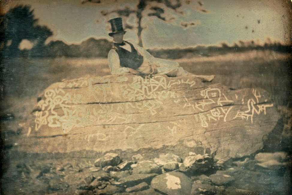
Seth Eastman on Dighton Rock, daguerreotype, 1853.

On February 1, 2014, I posted a column entitled "Dighton Rock - North America's Oldest Rock Art Report" about how this petroglyph boulder is the first known rock art site in America to be reported about. Dighton rock, however, holds another distinction in addition to being the subject of the first known rock art and archaeological site to be reported in writing. It may also be the subject of the first photograph taken of rock art in North America. 

On May 4, 2013, I posted a column entitled "The Oldest RockArt Photograph", in which I discussed a letter in Charles Darwin’s correspondence that mentioned an 1874 photograph of a bear pictograph from Picketwire Canyonlands that had been sent to Darwin. At that time I posited that it may be the oldest known rock art photograph, certainly in North America (although the photograph has not been located in Darwin’s correspondence).


                           Seth Eastman on Dighton Rock,
                               daguerreotype, 1853.

Now, I have another candidate for the title of oldest North American rock art photograph. In his 1991 book Fantastic Archaeology: The Wild Side of North American Prehistory (University of Pennsylvania Press, Philadelphia) Stephen Williams showed an 1853 daguerreotype of Dighton Rock in Berkley, Massachusetts. Williams described it as follows: “I believe that it (Dighton Rock) is the first American archaeological artifact to be captured by photographic means. Henry Rowe Schoolcraft, whom we encountered some pages ago with reference to the Grave Creek Stone, had as his major artist for his monumental six-volume work a young West Pointer named Seth Eastman. His busy army career took him from Minnesota to Texas and finally to the Seminole Wars in Florida.
Eastman, a talented artist, carefully documented Indian life on the frontier while on these military travels between 1829 and 1849. Though much of his work for Schoolcraft was studio-done on artifacts and the like, he did travel to New England, where he drew both the Dighton Rock and the Newport Tower. These drawings are all fine and good, but Eastman made archaeological history in 1853 when he sat atop Dighton Rock on shirtsleeves and a silk vest, with the inscription “enhanced” by chalk, and had a daguerreotype image made of the scene. What a way to be immortalized.
Schoolcraft used Eastman’s drawing of the Rock in his 1854 work.” (Williams 1991:215-6)

Online searching has turned up two versions of the photo; in one Eastman wears a top hat, and in the other version he is bare-headed. There are also variations that have the image reversed. In any case the early date of 1853 makes these daguerreotypes an excellent candidate for the title of Earliest Rock Art Photo!

REFERENCES:

Williams, Stephen
1991    Fantastic Archaeology: The Wild Side of North American Prehistory, University of Pennsylvania Press, Philadelphia.

Saturday, February 1, 2014

DIGHTON ROCK - NORTH AMERICA’S OLDEST ROCK ART REPORT?


Dighton Rock at mid-tide, in its original location.
http://www.dightonrock.com/dightonrockits
musuemanditspark.htm

When was the first report of a rock art inscription filed? Well, the first one to be reported that I know of was done in 1680 A.D. about Dighton Rock, in Berkley, Massachusetts. Kenneth Feder, in his Encyclopedia of Dubious Archaeology, From Atlantis to the Walam Olum (2010:80-81) explained it as follows:


Rev. Danforth's drawing, 1680. British Museum.

“The earliest extant record of the petroglyph-covered boulder dates to 1680, when an English settler Rev. John Danforth, produced a drawing of the images. Unfortunately for those who believe that the marks on Dighton Rock represent the equivalent of graffiti left by ancient European (or African or Asian) seafaring visitors to America’s shores, it should be pointed out that Danforth’s drawing of the markings he saw look virtually nothing like what can currently be seen there today.” (Feder 2010:80)


Dighton rock, en.wikipedia.org, public domain.

The Dighton rock is described in Wikipedia as - “ a 40-ton boulder, originally located in the riverbed of the Taunton River at Berkley, Massachusetts (formerly part of the town of Dighton). The rock is noted for its petroglyphs ("primarily lines, geometric shapes, and schematic drawings of people, along with writing, both verified and not."), carved designs of ancient and uncertain origin, and the controversy about their creators. In 1963, during construction of a coffer dam, state officials removed the rock from the river for preservation. It was installed in a museum in a nearby park, Dighton Rock State Park. In 1980 it was listed on the National Register of Historic Places (NRHP).
The boulder has the form of a slanted, six-sided block, approximately 5 feet (1.5 m) high, 9.5 feet (2.9 m) wide, and 11 feet (3.4 m) long. It is gray-brown crystalline sandstone of medium to coarse texture. The surface with the inscriptions has a trapezoidal face and is inclined 70 degrees to the northwest. It was found facing the water of the bay.” (Wikipedia)
Reverend Danforth produced a drawing of the petroglyphs in 1680, which still exists in the British Museum, although his drawing is considerably different from others that followed, and from what can today be seen on the rock. (Wikipedia)

“Ten years after Danforth drew the markings, the famed Rev. Cotton Mather noted the existence of the marked stone and said about the petroglyphs:
“Among the other Curiosities of New-England, one is that of a mighty Rock, on a perpendicular side whereof by a River, which at High Tide covers part of it, there are very deeply Engraved, no man alive knows How or When about half a score Lines, near Ten Foot Long, and a foot and half broad, filled with strange Characters: which would suggest as odd Thoughts about them that were here before us, as there are odd Shapes in that Elaborate Monument.”” (Feder 2010:80)

We all know that much of what is seen in rock art depends upon the sympathies of the viewer. In the case of Dighton Rock, however, the range of what is seen reached the extreme.
Sewell's drawing, 1764.

“Several other sources for the Dighton Rock petroglyphs have been cited, all of which depend on the assertion that European, Asian, or African explorers were present in New England at some point before the arrival of English settlers in the seventeenth century. A long-standing suggestion is that the markings were left by the Portuguese explorers Gaspar and Miguel Corte Real. Brown University professor Edmund Burke Delabarre became convinced that among the admitted hodgepodge of scratches, X’s, lines, circles, geometric shapes, and whatnot, there was an actual written message in Portuguese: “Miguel Cortereal by will of God, here Chief of the Indians.” - -
Others look at the same rock and see completely different messages in completely different languages. Danish writer Carl Rafn saw the name of Thorfinn Karlsefni, whose name also shows up in the Norse sagas about the discovery of Newfoundland.
Gavin Menzies (2002, 333-35) looks at exactly the same series of markings and proposes that they were left by Chinese world explorers.” (Feder 2010:81)


Rhode Island Historical Society drawing, 1830.

Now Feder’s inclusion of Dighton Rock in his Encyclopedia of Dubious Archaeology has nothing to do with questioning its authenticity, he was writing about the many outlandish interpretations it has inspired. I previously had read Cotton Mather’s account of Dighton Rock, but did not know of Rev. Danforth’s record until reading this book. We all know that much of what is seen in rock art depends upon the sympathies of the viewer, and we often see what we expect to see. Perhaps people should expect less, and study the facts more! In any case, until I see an earlier record of North American rock art I will list Reverend Danforth's drawing as the earliest North American rock art record.

NOTE: Dighton Rock has been moved into a small museum built for the purpose, and is now Dighton Rock State Park, at Berkley, Massachusetts.

REFERENCES:

Feder, Kenneth L.
2010    Encyclopedia of Dubious Archaeology: From Atlantis to the Walam Olum, Greenwood, Santa Barbara, Denver, and Oxford.

Wikipedia