Saturday, May 29, 2021

IRANIAN PETROGLYH DESIGNATED AS THERIANTHROPIC MANTIS/MAN:

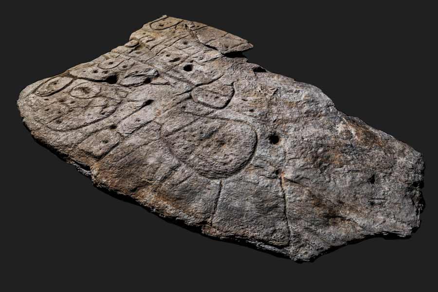
Mantis/Man therianthrope petroglyph, Iran. Photograph M. Naserifard.


        Drawing of the petroglyph, after M.                                    Kolnegari.

An interesting petroglyph found in Iran was recently published in the Journal of Orthoptera Research by a team of Iranian researchers. They named this therianthropic image the Mantis Man because of a definite resemblance to a praying mantis. The petroglyph has three main features that resemble the insect; six legs, a triangular head, and the fore limbs are poised or cocked to strike like a praying mantis.


Praying Mantis. Internet photograph, Public Domain.


Drawing of praying mantis, after Natalie Clifton. Public Domain.

The only real deviation from the resemblance to a praying mantis is that instead of two antennae on the head this petroglyph only has one line projecting outward, but that is a small error compared to the points of resemblance. So, was this image intended to be a reference to a mantis? I can go along with that.

Then, however, the whole thing went sideways fast. Not just content with making what seems to be an accurate interpretation of the petroglyph, the authors go on to involve the whole “Plasma Universe” fallacy.


"Squattin man" image, from Van der Sluijs and Peratt, 2010.

“The specific shape of the mid-legs and hind legs are the deceptive parts of the motif that could mislead the identification process. In fact, the entire appearance of the motif is comparable with particular anthropomorphs that show a man-like figure having two dots on either side of the midsection. - The symbol named ‘squatter man’ (‘squatting man”) and some archaeologists believe that the motif is associated with aurora phenomenon due to plasma discharge, specifically a ‘Z-pinch instability’. This anthropomorph has been discovered in several regions including northern Arizona, Tucson, Arizona, New Mexico, Armenia, Spain, Tyrolian Alps, Italy, United Arab Emirates, Guyana, and Venezuala.” (Kolnegari et al. 2020)


Diagram of the supposed "z-pinch" plasma arc. From Van der Sluijs and Peratt, 2010.

Now I have known archaeologists and rock art researchers who carry a little intellectual baggage with them in the form of beliefs. From ‘shamanism’, to La Van Martineau’s reading of rock art panels, many of us have mental foibles mixed in with knowledge. I even know a rock art researcher who believes in (and has seen) flying saucers.

But this Z-pinch plasma inspired bent-legged man theme is pretty much the silliest proposal I have ever seen. It is based upon the proposition that anthropomorphic figures with bent arms and legs were inspired by a phenomenon from plasma physics caused by a massive solar coronal mass ejection striking the earth, resulting in a “z-pinch” of the aurora.

“What would the sky look like if the solar wind was further increased by one or two orders of magnitude? Although we have no scientific proof that this has ever happened, the American astronomer, Thomas Hold (1920-2004), proposed that such an event did happen within the past 12,000 years. Unfortunately, we have no visual depictions of what such an event would have looked like, but thanks to the affiliation of one of the authors with the Los Alamos National Laboratory, it was possible to use the world’s fastest computer, Roadrunner, to simulate the evolution of an aurora under the influence of  such a massive solar wind. Apparently the aurora would assume different shapes than the familiar frivolous waves, rays, and ripples and take on a less scattered, more concentrated form. As its height profile is altered, a column forms that joins the magnetosphere of the earth to the solar wind. Expected structures include pinched ropes of a ‘sausage’ type, helices, concentric circles, filamentary ‘rays’ that intertwine and merge, and the emergence of ‘plasmoids’ shaped like orbs or eggs. As such a configuration achieves a degree of semi-stability, moreover, the event would last considerably longer than ordinary auroral outbursts, allowing petroglyph carvers to depict aspects, depending on their own point of view on earth. The snapshot results of the different stages of the simulated aurora appear to match closely many of the so-called abstract petroglyphs seen around the world. - - - So, could these enigmatic petroglyphs be evidence that humans witnessed intense auroral storms in the past? We believe this is the case and have reason to postulate three episodes of auroral activity of this type, accompanied by rock art carving, which occurred between roughly 10,000 and 3,000 BCE. Although it is wise to keep one’s feet on the ground at all times, it is clear that archaeologists could benefit much from lifting their gaze up to the heavens. The sky was as much a part of the ancient’s environment as the earth.” (Van der Sluijs and Peratt 2010:38-40)

This is based in a theory of Plasma Cosmology which had been put forward in the late 1930s and 1940s as an alternative to Einstein’s gravity dominated cosmology. So, in summation, what had been a thoroughly interesting discovery of a petroglyph in Iran, has now sullied by an interpretation even more ridiculous than UFOs, crop circles, and animal mutilations. Too bad.

NOTE: I am somewhat dismayed, not only as a rock art researcher but as a taxpayer, that Anthony L. Peratt was allowed to use the super computer at Los Alamos National Laboratory at taxpayer expense to pursue his silly theory that petroglyphs were inspired by super plasma phenomena. This may be science, but it is not good science.

Also - Some images in this posting were retrieved from the internet with a search for public domain photographs. If any of these images are not intended to be public domain, I apologize, and will happily provide the picture credits if the owner will contact me with them. For further information on these reports you should read the original reports at the sites listed below.

REFERENCES:

Kolnegari, Mahmood, Mohammed Naserifard, Mandana Hazrati, Matan Shelomi, 2020, Squatting (squatter) mantis man: A prehistoric praying mantis petroglyph in Iran, Journal of Orthoptera Research 29(1): 42-44, https://doi.org/10.3897/jor.29.39400 (13 March 2020)

Van der Sluijs, Marinus Anthony, and Anthony L. Peratt2010, Searching for Rock Art Evidence for an Ancient Super Aurora, Expedition Magazine, Vol. 52, No. 2, pp. 33-42, Penn Museum, Philadelphia, PA, https://www.penn.museum/sites/expedition/p=12874

Saturday, May 22, 2021

A WHOLE NEW TYPE OF ROCK ART - AMMOGLYPHS:


"Hashtag" ammoglyph, photograph www.ancientorigins.net.

It is not often I get to pass along news about a whole new kind of rock art, but it was with some excitement that I found this report of a team of South African researchers who have discovered ammoglyphs. These originated as human created designs in beach sand which was later turned to sandstone, preserving the markings in the process, voila - rock art.


Trace fossils of sand ripples on a beach turned to sandstone. Internet photograph, Public domain.

In the past I have seen many examples of ripple marks from water preserved in stone. Indeed, I have long been fascinated by the trackways of extinct animals preserved as trace fossils when beach sand has been cemented into sandstone. I have even been aware that in recent decades hominin tracks in stone have been discovered. What I was not expecting was that doodles or drawings left in the sand by these beings would have been preserved and could be recorded as a form of rock art.


Divided triangle ammoglyph. Photograph Charles Helm.

“An ammoglyph (‘ammos’ being Greek for ‘sand’, and ‘glyph’ being Greek for a carving, image, or symbol) is a name given to fossilized art works created by early humans. They are a special kind of aeolianites. This term was coined by Charles William Helm, lead researcher in the excavation of these fossilized pieces and is a relatively new discovery within the 2019 year.

Deliberate sand impressions have been discovered made in former sand dunes and beach deposits that have now been fossilized into rock and re-exposed through the process of erosion. They were first noticed in coasts in the region of South Africa, an area rich in early rock art. They are dated to the Middle-Late Pleistocene, approximately 158,000 to 70,000 years ago. The sand impressions are theorized to have shown indications of foraging or development of symbols and patterns as a means of communication or art. Such patterns that have been discovered include repetitive figures in the shapes of circles and stylistic techniques that display lines in zig-zags, parallel lines, and cross-hatches.” (Wikipedia)

Helm, a Research Associate at the African Centre for Coastal Palaeoscience, Nelson Mandela University first began studying trackways in British Columbia, but moved to South Africa where he found much more fertile ground.


Fossilized hominin track. Photographs Richard Helm, 2020.

“These rock surfaces don’t just show where and how our ancestors walked or jogged. They also reveal how they foraged or left stone tools - and made patterns in the sand. The patterns that we have found consist of circles, grooves, ‘hashtags’, fan shapes and even what appears to be a sand sculpture that resembled a sting-ray. In our research paper about these discoveries, we introduced the term ‘ammoglyph’ to describe a pattern created by humans in sand that is now evident in rock. Now we’ve discovered two new triangular patterns that we believe are ammoglyhs. This is yet more evidence that South Africa’s coastline is a place where our human forebears became truly modern. Here they developed the complex cognition that defines us today.” (Helm 2021)

Some of the markings found were probably produced accidentally as the hominin walked across the sand, perhaps with a walking staff, or dragging something, but others seemingly would have had to be purposefully created. You don’t get the hashtag patterns, the triangular patterns, or the protractor-created circle by accident.


Protractor created circle ammoglyph. Photograph Charles Helm.


Charles Helm re-creating creation of the circle. Photograph Linda Helm.

The latter, in particular, indicates complex cognition and planning. A forked stick, used like a protractor, with one arm pushed into the sand as a pivot that the other arm was rotated around. This one even shows the impressions of the knees of the hominin who kneeled in the sand to make the design.

I find this stuff very exciting. No dispassionate scientific consideration here, this is a big deal.

NOTE: Some images in this posting were retrieved from the internet with a search for public domain photographs. If any of these images are not intended to be public domain, I apologize, and will happily provide the picture credits if the owner will contact me with them. For further information on these reports you should read the original reports at the sites listed below.

REFERENCES:

Helm, Charles, 2021, What Triangular Patterns on Rocks May Reveal About Human Ancestors, 26 April 2021, https://phys.org

Helm, Charles W., M. Lockley, H. Cawthra, J. D. Vynck, M. Dixon, C. J. Helm, and Guy H. H. Thesen2020, Newly Identified Hominin Trackways From the Cape South Coast of South Africa, South African Journal of Science, DOI:20.27259/SAJS.2020/8156

WikipediaAmmoglyph, https://en.wikipedia.org/wiki/Ammoglyph


Friday, May 14, 2021

 OBITUARY: 

Dr. William S. Hammond, 7 May 1931 to 4 February 2021. 

We just found the announcement on 10 May 2021 of the passing of our friend Bill Hammond. I have known Bill in the Colorado Archaeological Society (CAS) for going on forty years, and while Bill was not particularly interested in rock art he was willing to discuss almost anything concerning archaeology at length. This made him a excellent collaborator and valued friend. About 12-years ago Bill recommended to the CAS board that I replace him as CAS representative on the Board of History Colorado and the Archaeology and Historic Preservation Committee which he was leaving because of ill health. I have been honored to serve there in his stead ever since.

I am not going to list his lifetime of accomplishments, descendants, education, and all of the other traditional required contents of an obituary. That can be looked up in the Denver Post obituary. This is intended instead, to be a short reminiscence of a friend.

The last time I saw Bill in person he came over because he knew that I had a digital microscope. He produced a pill bottle that contained a small piece of bone with a dot pattern along the edge that had been recovered in the excavations at Ken-Caryl which he led for many years. We spent a happy half-hour examining this fragment of bone trying to picture what was missing from the shape of what we had. It was pretty clearly a bone pendant with the delicate dot pattern, and we had the joy and satisfaction of the search for knowledge together. Those who knew him knew his gentle excellence as well as his passion for knowledge. I will miss Bill, as will the whole of the Colorado Archaeological Society. The smile says it all.

Saturday, May 8, 2021

A CARVED SLAB IN FRANCE IS CLAIMED TO BE THE OLDEST MAP IN EUROPE:


St. Belec slab, France. Photograph ancientorigins.net.

Well, here we go again. Another carved stone slab has been designated as a map, and not just any map. No, this map has been designated the oldest map in Europe.

Readers of RockArtBlog should know that I am very skeptical of claims of maps in rock art. I have gone so far as to say that I have not seen one yet in North America that I can agree is a map. It seems that when confronted by a mess of tangled lines on the rock face the fallback position for amateurs is always “that is a map of the surrounding area”. Indeed, the very first column I wrote for RockArtBlog was “Are There Maps In Native American Rock Art,” on April 18, 2009, debunking a claimed map on a petroglyph panel in southeastern Colorado.


Qenqo, Peru. Internet photograph, Public Domain.

In other locales, and other situations, I can accept the concept of a carved stone map, Q’enqo, in Peru, and a few other locales, have Incan carve stone representations of  miniature landscapes that are thought to have been used in rituals. This might just be the case with the Saint-Belec slab.

The authors of the analysis believe it is a map meant to represent its surrounding region. “A recent re-examination of the Saint-Belec slab suggests that its sculptured surface and scattered motifs represent the surrounding landscape and a series of contemporary structures now known from archaeological evidence.” (Nicolas et al. 2021)


                      St. Belec slab, France.                   Photograph Bournemouth University, UK.

“When discovered, the slab formed the western side of one of the largest stone-cists in the region. It was orientated east-west and measured 3.86 m long, 2.1 m wide, and 1.86 m high.” (Nicolas et al. 2021) In other words it was used as part of the structure of a burial chamber under a mound or barrow. The work of constructing a stone burial chamber and raising a barrow over it suggests that the person buried inside was of some importance. The Bronze Age date assumed for this rock seems to be the result of its incorporation into a structure dating from that period, plus the fact that the authors state it does not bear any resemblance to earlier Neolithic carvings.

“A key point is that the engravers seem to have modified the original surface relief of the slab to create the desired 3D-form that compares to the topography of the surrounding landscape, the Odet River valley, overlooked by the Saint-Belec barrow. Furthermore, a series of lines appear to figure a more extended river network. To test this hypothesis, we have led several network and shape analyses that confirm a good correspondence between the carvings and the topography, with similar results to ethnographic solicited maps. Such correlations give the opportunity to georeference the Saint-Belec slab and get an idea of the possible scale of the space represented: an area c. 30 km long and 21 km wide. Furthermore, the carved motifs might have depicted early Bronze Age settlements, barrows, field systems, and tracks.” (Nicolas et al. 2021)

                    St. Belec slab, France.        Photograph Bournemouth University, UK.

“While there are relatively few blank areas on the decorated surface, there is very little overlap of the motifs, except at their ends. Therefore, it appears that the successive phases in creating the panel did not significantly change the overall composition but were rather added in a planned way.” (Nicolas et al. 2021) In other words, there seems to have been a plan for the composition which was worked on until completed and then the surface was essentially left alone.

”One outstanding question about the Saint-Belec slab is why it was made? One possibility is that such a territorial depiction was a material and symbolic act enforcing. Set alongside the contemporary development of field systems in Brittany making the slab perhaps suggests the appearance of a new form of land tenure., while the distribution of elite graves is closely linked to soil fertility. Against this background, we can hypothesize that the Saint-Belec slab was used as a cadastral plan for managing the territory and controlling land.” (Nicolas et al. 2021) My interpretation of this statement is that the authors believe that this slab, representing a map of the surrounding area that the elite possessor had influence over, would have been used in the same fashion as a stereotyped military commander in a movie standing over his map table and making plans for actions.

I would like to suggest another possibility; where the authors state that “the Saint-Belec slab was used as a cadastral plan for managing the territory and controlling land,” I would like to suggest that it may have had a ritual function such as the above mentioned Q’enqo in Peru, where rites performed over the surface of this representation of the territory may have magically and/or spiritually effected the territory itself, perhaps for annual fertility rites, or magical security and protection.

In any case, if it was indeed used in such a fashion by an elite owner, it must then have been built into the wall of that elite’s tomb upon death and burial. So, in this case, I find myself agreeing that this may indeed be a map in rock art, but in this specialized way, not as an image per se of the land surface itself, but as a spiritual go-between representing the large area of land depicted.

NOTE: Some images in this posting were retrieved from the internet with a search for public domain photographs. If any of these images are not intended to be public domain, I apologize, and will happily provide the picture credits if the owner will contact me with them. For further information on these reports you should read the original reports at the sites listed below.

REFERENCES:

Faris, Peter, 2009, Are There Maps In Native American Rock Art?, April 18, 2009, https://rockartblog.blogspot.com

Nicolas, C., Y. Pailler, P. Stephan, J. Pierson, L. Aubry, B. Le Gall, V. Lacombe, and J. Rolet, 2021, La Carte et le Territoire: La Dalle Gravee du Bronze Ancien de Saint-Belec (Leuhan, Finistere), April 2021, Bulletin de la Societe Prehistorique Francaise, tome 118, 1, p. 99-146.

Saturday, May 1, 2021

HIGH ON HYPOXIA - DID OXYGEN DEPRIVATION INSPIRE PALEOLITHIC CAVE ART?


Painted wall at Chauvet Cave France. Photograph from www.donsmaps.com.

“Don’t take the brown acid, it’s bad” Does anyone remember Wavy Gravy’s announcement at Woodstock? This came to mind as I read a silly recent article from a team of Israeli rock art researchers. It explained that Paleolithic artists placed their artistic masterpieces so deep in caves because they were inspired by the effects of brain hypoxia. Brain hypoxia is the condition resulting from insufficient oxygen being delivered to the brain by the bloodstream. 

According to Healthline.com: “Brain hypoxia symptoms range from mild to severe. Mild symptoms includeTemporary memory loss, Reduced ability to move your body, Difficulty paying attention, and Difficulty making sound decisions. Severe symptoms includeSeizure, Coma, Brain death.” (Badii 2018) What on this list sounds like creativity? Creative production in the visual arts not only requires physical activity and a great deal of dexterity, precision and coordination, it is a rigorous mental activity that requires decision making, judgement, memory, and concentration, exactly the opposite of the effects of hypoxia. Yet this is exactly what a recent Israeli study claims.

"The study explains why so many ancient paintings are deep inside cave system(s). Prehistoric cave dwellers living in Europe purposefully starved themselves of oxygen to hallucinate while creating their decorative wall paintings, a groundbreaking new study has found. Researchers have been questioning for years why so many of the world's oldest paintings were located in often pitch-black tunnel systems, far away from cave entrances. But a recent study by Tel Aviv University now reveals that the location was deliberate because it induced oxygen deprivation and caused cavemen to experience a state called hypoxia." (Ankel 2021)


Lions, rhinos, and bison, Chauvet Cave, France. Internet photograph, Public Domain.

It is true that psychedelic hallucinations were associated with some art in the late 60s and 70s but this was usually the psychedelic art associated with the Hippies or high abstract expressionism. No realist painter would have been helped by the effects of psychedelics, let alone hypoxia.

"'People have always been fascinated by caves. Underground cavities and hollows in mountains played a special role in the ontology and cosmology of indigenous societies, past and present' Yafit Kedar, a PhD candidate in the Department of Archaeology and Near Eastern Studies at Tel Aviv University explained. Kedar's research focuses on understanding the implications of smoke dispersal and air circulation on humans at Paleolithic caves and rock shelters." (Tercatin 2021)

"According to Ran Barkai, the co-author of the study, the cavemen used fire to light up the caves, which would simultaneously also reduce oxygen levels. Painting in these conditions was done deliberately and as a means of connecting to the cosmos, the researcher says. 'It was used to get connected with things,' Barkai stated, adding that the cave painters often though of the rock face as a portal connecting their world with the underworld, which was associated with prosperity and growth. The researcher also suggested that cave paintings could have been used as part of a kind of initiation rite." (Ankel 2021)

"'The natural oxygen concentration in the atmosphere is 21%.' Kedar explained. ' A lower concentration of oxygen creates a condition known as hypoxia.' Hypoxia officially occurs when the oxygen concentration is below 18%. Its symptoms, the researchers pointed out, include dizziness and headaches but also euphoria and an increase in the release of dopamine - which can lead to hallucinations and out-of-the-body experiences, especially if the level of oxygen drops below 14.5%." (Tercatin 2021)

This statement is erroneous, these figures are far from absolute. They state that hypoxia occurs as oxygen concentration is below 18%. The effective oxygen concentration in Boulder, Colorado is 17.3%. I have lived in Boulder and went to graduate school there and functioned just fine. The effective oxygen concentration in Aspen, Colorado is 15.4% and I, and most other people do just fine in Aspen. The authors say that there will be "hallucinations and out-of-body-experiences" if oxygen drops below 14.5%. The effective oxygen concentration at the altitude of Leadville, Colorado is 14.3%. I have been to Leadville and done just fine. I know artists in Leadville who paint very well without "hallucinations and out-of-body-experiences."


Horses, Chauvet Cave, France. Photograph Wikipedia.

So, if our erstwhile cave artist is actually experiencing that euphoria and hallucinations along with his dizziness and headaches I can picture him perhaps summoning up the energy and concentration to make a handprint, a smear of some sort, or a simple abstract pattern, and, in fact, all of these can be found in cave painting. What I cannot picture is that same cave artist producing the masterful paintings of Chauvet, Lascaux, Altamira, or any of the other acknowledged examples of masterpieces of art found in caves. That quality and level of creation requires much more decision making, judgement, memory, and concentration to pull off. The beautiful horses, lions, bison, rhinos, and other animals in Chauvet and the other caves are not the result of hallucination, they are the result of the deliberate and sober use of the highest level of human analysis and creative concentration.

I believe that the authors of this so-called scientific study came up with their theory of oxygen deprivation prompting the paintings in the far depths of caves and then pushed it to what they saw (or wanted to see) as its logical conclusions, without referencing it to the reality of facts, ending up going down their own imaginative cave with Alice and the Cheshire Cat, not based in the real world.

Indeed, that the authors may have had some reservations in their theory is suggested by this statement from the discussion section of their paper. “It is also possible that people who are accustomed to the alternate states of consciousness induced by hypoxia could become somewhat inured, with the symptoms decreasing after recurrent visits to the cave. Perhaps these people retained their ability to perform some of the practical tasks associated with their endeavor, such as building scaffolding, guiding others, or executing the depictions, while less experienced visitors to the cave would have been much more severely affected.” (Kedar et al. 2021)

I would like to suggest to them a different interpretation of their story which might be more plausible. The quality of the fine art itself disproves their theory as stated so we can assume that one or a few artists with their small oil lamps did not use up so much oxygen that they went into hypoxia when the art was being created. If, however, a larger number of people gathered together there with their larger number of light sources, then the oxygen might have been depleted by the larger crowd. If they gathered there for some sort of ceremonial purpose that included the art as a background, then perhaps the audience may have experienced mild hallucinations from hypoxia. This would enhance the experience and the effects of the art. So, not for the artists, but for the audience, this theory might make a little more sense - but note, this is not what the authors claimed.

I am aware that this whole argument is a little simplistic and overlooks variables like the human body adapting to various environments, but, I would argue, their whole premise is even more simplistic and I just cannot buy it.

NOTE: Images in this posting were retrieved from the internet with a search for public domain photographs. If any of these images are not intended to be public domain, I apologize, and will happily provide the picture credits if the owner will contact me with them. For further information on these reports you should read the original reports at the sites listed below.

REFERENCES:

Ankel, Sophia, 2021, Prehistoric Cavemen Starved Themselves of Oxygen to Induce Hallucinations and Inspire Their Ancient Paintings, Study Finds, April 11, 2021, https://news.yahoo.com  

Badii, Chitra, Brain Hypoxia, September 29, 2018, medically reviewed by Seunggu Han, M.D., https://www.healthline.com/health/cerebral-hypoxia#symptoms 

Kedar, Yafit, Gil Kedar and Ran Barkai2021, Hypoxia in Paleolithic Decorated Caves: the Use of Artificial Light in Deep Caves Reduces Oxygen Concentration and Induces Altered States of Consciousness, Time and Mind (Journal), DOI:10.1080/1751696X.2021.1903177

Tercatin, Rossella2021, Stoned in the Stone Age: Prehistoric Humans Got High - Israeli Scholars, April 8, 2021, The Jerusalem Post