Showing posts with label Columbia River. Show all posts

Saturday, September 10, 2022

THE SPEDIS OWL ON A BUTTON:

Spedis Owl, The Dalles, Wasco County, Oregon. Photograph J & E Faris, October 1991.

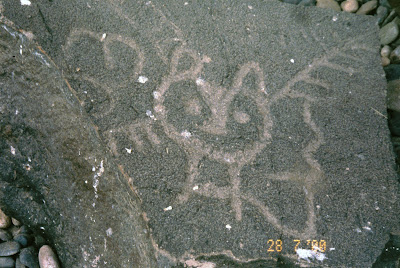
Spedis Owl, The Dalles, Wasco County, Oregon. Photograph  Peter Faris, 28 July 2000.

Spedis Owl near Spearfish Lake, Washington. Photograph from columbiagorge.org

During the summer of this year (2022) I was contacted by the editor of a niche publication named the National Button Bulletin concerning a photograph from a previous column in RockArtBlog. On 2 August 2010, I had posted a column titled “Birds in Rock Art – The Spedis Owl.” This refers to a number of distinctive owl petroglyphs found in the Columbia River gorge in an area centered around the Dalles Dam. I was told that a writer named Anne Morgan was working on an article on buttons with owl motifs and that she was including a button with the Spedis owl portrayed on it. I provided the above photograph of one Spedis owl petroglyph and subsequently received a pre-publication copy of the article.

Illustration from National Button Bulletin, 2022.


Spedis Owl pewter button, manufactured by Columbia Legends Company, Dalles, OR. Illustration from National Button Bulletin, 2022.

“The Spedis Owl is a petroglyph that originally stood above Celilo Falls on the Columbia River in Oregon. The falls were destroyed by the Dalles Dam project in the 1950s. Prior to its flooding, Celilo Falls stood for over 10,000 years as an iconic salmon harvest and multi0tribal gathering site for Pacific Northwest Native Americans. It is not known which tribe drew the image on the rock or what the owl figure represented. One (among many) Northwest stories describes the Spedis Owl as a River Guardian, a protector of fishers and travelers from the water devil who lived within the dangerous and rolling Celilo Falls (Melin and Dolezal, n.d.). Prior to the Dalles Dam flooding, the Army Corp of Engineers salvaged the Spedis Owl and other related petroglyphs. They are now located in Columbia Hills State Park along the Washington side of the Columbia River. (Faris 2020)”

Modern fishing platforms at The Dalles, Klickitat County, WA. Photograph Peter Faris, April 2005.

The information provided to Morgan by Melin and Dolezal is not strictly correct. The distinctive Spedis Owl petroglyphs are in the vicinity of the site of a previous village of the Wishram people named Nixluidix, which is now beneath the reservoir created by The Dalles Dam. Melin and Dolezal also discuss the Spedis Owl as “a River Guardian, a protector of fishers and travelers from the water devil who lived within the dangerous and rolling Celilo Falls.” (Melin and Dolezal n.d.) Celilo Falls, where The Dalles Dam is now located, was a prime fishing location for harvesting salmon. The Wishram people of Nixluidix were prosperous traders of dried salmon harvested from the Columbia River.
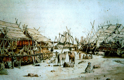
Drying Salmon at Nixluidix, The Dalles, Paul Kane painting, 1848.

“Located near Five Mile Rapids, the village was located at the far eastern reach of Chinookan lands. Archaeologists believe the site was occupied for about 10,000 years. The village was a common trading site for Indians in the surrounding areas, acting as a link between tribes from the Pacific Coast, and the interior Northwest. The site was visited by nearby Yakamas, as well as those from as far away as the Nez Perce, who would come to trade fish, berries, skins, buffalo, amongst many other items.

Dipnet fishing at Celilo Falls, 1899, near The Dalles, Klickitat County, WA. Internet photograph, public domain.

The village was visited during the westward journey by Lewis and Clark, and again on their eastward return journey, though by the time of the second visit, the village was at a site about 300 yards (270 m) downstream from the site visited the previous fall, Lewis and Clark estimated that there were about 600 people living at the site during the first visit (October 1805), and around 1,000 during the second visit (April 1806). Clark noted in his journals that there were about 20 wooden houses at the site, near a man-made earthen mound called Wakemup (or Wakamup) Mound.” (Wikipedia)

Although Clark had mentioned and sketched rock art in a few instances in the journal that he kept on their trip, he did not mention any rock art at Nixluidix from both their visits there, so Lewis and Clark apparently missed out on the Spedis Owl. The name Spedis is believed to have been taken from an early farmer, a Mr. Spedis, who homesteaded there (James Keyser 2000: pers. comm.) Indeed, the 1930 US Federal census listed fifteen members of the Spedis family still residing in Klickitat County, Washington.

I am quite tickled to have been a small part of this commemoration of a charming rock art theme.


NOTE: Some images in this posting were retrieved from the internet with a search for public domain photographs. If any of these images are not intended to be public domain, I apologize, and will happily provide the picture credits if the owner will contact me with them. For further information on these reports you should read the original reports at the sites listed below.

PRIMARY REFERENCES:

Faris, Peter, 1970, Birds in Rock Art – The Spedis Owl, https://rockartblog.blogspot.com/2010/08/birds-in-rock-art-spedis-owl.html 

Morgan, Anne, 2022, Much More Than the Wise Old Owl: Myths, Art and Culture, October 2022, The National Button Bulletin, pp. 161-167

Wikipedia, Wishram Village, https://en.wikipedia.org/wiki/Wishram_village.

Saturday, January 23, 2021

UNDERWATER ROCK ART: PART 3 - ROCK ART DROWNED BY HUMAN ACTIVITY.

Another category of underwater rock art has to be sites that were flooded intentionally with dams for hydroelectric power, or for irrigation impoundment, and navigational locks.


Horses, Coa Valley, Portugal, Photograph Wikipedia.


Aurochs, Coa Valley, Portugal, Photograph Wikipedia.


        Horses, Coa Valley, Portugal, Internet                         photo, Public Domain.

This was the case with the Paleolithic rock art of the Coa Valley (and others) in Portugal. “Portugal’s most important rock art finds of the last three decades, have a rather unfortunate association with dam projects like: Fratel dam on the river Tagus, Pocinho dam on the river Douro, river Coa dam, Laranjeira dem on the river Sabor, Alqueva dam on the river Guadiana. Some got lost in this project but some were preserved after a long struggle by the culture preservers, the local agencies, college professors and also societies.” (Tiwary 2014) The most famously reported was the project to dam the Coa river valley. The discovery of Paleolithic era petroglyphs in the valley caused archaeologists, preservationists, and others to advocate for preservation of these sites and many were saved, but it is unknown how many were lost. Likewise for the other valleys mentioned. This has, unfortunately, been a theme too well known throughout the world.

The United States has a long and unfortunate record on flooding archaeological and rock art sites with dams for hydroelectric power, or for irrigation impoundment, and navigational locks.


Ohio river petroglyphs, Smith's Ferry, Pennsylvania. Internet photo, Public Domain.

One early example of this was along the Ohio River, ironically along land owned some of which was owned by George Washington. His reward for serving the British Crown in the French and Indian War was a large plot of land along the Ohio River in the Ohio Territory that Washington visited in 1770. That stretch of the Ohio River originally sported tens of thousands of petroglyphs. “Although Washington did not mention the petroglyphs he apparently explored the area as he designated on section as good for a house and others as fine cropland. Given Washington’s attention to the details of the land it seems safe to assume that he would have had every opportinity to notice the petroglyph panels on horizontal sandstone in that area. For centuries, hundreds of these Native American carvings - or petroglyphs - stretched for about 10 miles along the Ohio River from Midland, Pa., through Wellsville, Ohio, to the Yellow Creek.” (Faris 2020)


Ohio river petroglyphs, Photograph from O'Brien, 2020.

“During the 1920s, a series of dams and locks was constructed along the Ohio, causing water levels along this part of the river to rise. By the 1950s, ‘super’ dams were added on the Ohio and the river rose even higher. Today, the petroglyphs are inundated under about 15 feet of water.” (O’Brien 2020)


Celilo Falls, Columbia River. Before the construction of The Dalles dam. U.S. Army Corps of Engineers photograph.


The Dalles Dam, Columbia River, USGS photograph.

When Lewis and Clark traveled the Columbia River gorge, on what is now the border between Washington and Oregon, they could have seen quite a bit of rock art. They visited a village of the Wishram people named Nixluidix which was located approximately where The Dalles dam is now located. “Interestingly, their eventual round down the Columbia river led past the site of the magnificent petroglyph now named Tsagaglalal (She Who Watches) but there is no hint in their records that they actually saw it. They visited a village of the Wishram people which was named Nixluidix by its residents. The Wishram were one of the Upper Chinook people and prospered in their location on trade, specifically in large quantities of dried salmon.” (Faris 2011)


Columbia River rock art, photographs Peter Faris, 1991.

Much of the Columbia river gorge was lined with basalt cliffs which contained a large quantity of rock art although Lewis and Clark did not mention it in their journals. The impoundment of The Dalles dam as well as other dams and locks inundated much of this rock art although some of it was rescued and can be seen displayed at sites in the vicinity. Remaining rock art on the cliffs above the water level of the impoundment is also exciting and worth a visit, but so much was lost.

This has also been the case with many other canyons such as the Colorado River in the American southwest. In the canyons along the Colorado River, the Glen Canyon dam and the Hoover dam as well as other projects have submerged thousands, if not tens of thousands, of rock art and other archaeological sites. This will not always need to be considered a negative effect however. Perhaps being underwater, however, will protect rock art from vandalism. I recall hearing a report from one rock art recording project in northern New Mexico decades ago, in the neighborhood of the Navajo Lake Reservoir that had submerged many rock art and other cultural sites. When their Navajo guide was asked what he thought about their sites and rock art being submerged under hundreds of feet of water he was reportedly quoted as having replied “It’s safe from you now.”

NOTE: Once again RockArtBlog wishes to thank Sachin Tiwary for his cooperation in this, and permission to cite his paper (below) and use his photographs. This effort would be incomplete without his assistance, and would not have happened without his original inspiration.

ALSO: Some images in this posting were retrieved from the internet with a search for public domain photographs. If any of these images are not intended to be public domain, I apologize, and will happily provide the picture credits if the owner will contact me with them. For further information on these reports you should read the original reports at the sites listed below.

REFERENCES:

Faris, Peter, 2020 George Washington May Have Seen These Ohio River Petroglyphs, November 7, 2020, https://rockartblog.blogspot.com/search/label/George%Washington

2011 Rock Art of Lewis and Clark, December 31, 2011, https://rockartblog.blogspot.com/search/label/Lewis%20and%20Clark

Grant, Campbell, 1967 Rock Art of the American Indian, Promontory Press, New York

O’Brien, Dan, 2020 Learn the Mystery of the Ohio River Petroglyphs,The Business Journal, Youngstown, Ohio, https://businessjournaldaily.com/mystery-of-ohio-river-petroglyphs/

Tiwary, Sachin Kr., 2014 Underwater Rock Art: In Global Context, En Rupestreweb, http://www.rupestreweb.info/underwaterrockart.html


Saturday, September 14, 2019

BOOK REVIEW - VISIONS FOR LIFE AND DEATH: PICTOGRAPHS OF THE LOWER COLUMBIA RIVER:

VISIONS FOR LIFE AND DEATH: PICTOGRAPHS OF THE LOWER COLUMBIA RIVER,  Keyser, James D., David A. Kaiser, and David L. Minick.


Front cover.

I have received another volume of rock art in the series published by the Oregon Archaeological Society; Visions for Life and Death: Pictographs of the Lower Columbia River, by Keyser, James D., David A. Kaiser, and David L. Minick, 2019, Oregon Archaeological Society Publication #26, Portland, Oregon. (www.oregonarchaeological.org) I have personal ties (family history) to the region, and have spent considerable time there, so I was pleased to be able to delve deeper into the rock art and customs of the aboriginal inhabitants of that (the Dalles/Deschutes) area. The bulk of the rock art there is found to be either Central Columbia Plateau Style, or Yakima Polychrome Style. I have some little familiarity with these as, back in August 1983, I had visited a large Yakima Polychrome style site on a cliff by the river at Yakima, Washington, and, in July 2000, I had the opportunity to spend a day with Jim Keyser examining rock art in this (the Dalles/Deschutes) area, including some of the Spedis Creek panels (I have had a few other opportunities to visit rock art around the Dalles as well). This is some of my favorite rock art and I am very happy to have this detailed book about it.
Map of the study area.
Fig. 2, p. 3.

"Painted at two sites in the lower Columbia River region are fascinating sets of pictographs detailing the ritual activities of the people who have lived along the Columbia and Deschutes rivers for thousands of years. Bright red and red-and-white polychrome pictographs found at Spedis Creek and Harris Canyon document the vision quests of shamans and laypersons and show the deeply held beliefs people had about the Supernatural world. Informed by ethnography and mythology, these paintings are a testament to generations of people practicing their customs and passing their traditions and knowledge on to others. 
With dozens of photographs and color plates, accompanied by other illustrations, as well as various maps and charts, the authors present the first detailed study of a Yakima Polychrome type site. In addition, they undertake a detailed comparison between that site and a much simpler group of pictographs at the nearby Harris Canyon site."  
This publisher's statement from the back cover of the book only begins to describe this volume. 


Columbia River canyon
in study area,
Fig. 3, p. 4.

With a wealth of photographs as well as comparative tables and charts, the imagery from this study area is integrated with rock art of the greater region. It should be noted that this is also the area that houses the great Tsagaglalal, "She Who Watches", but that is slightly outside the study area covered by this volume.


Black and white recording,
Fig. 5, p. 12.

As important as the results of such a comprehensive study are, there is another important aspect of this, the process itself. Because they were not allowed to do mylar tracings (by the Washington State Parks Department) the black and white images which look like marvelously detailed field drawings are actually photographs processed with D-stretch, Photoshopped, and then printed in black and white. "During the Spedis Creek/Harris Canyon project we made no direct tracings of the pictographs or petroglyphs at either site. Instead we based our recordings of the imagery entirely on color digital photography. This exclusive reliance on color photography results in some issues that must be discussed. The first is our production and use of what we term photo-tracings. There are two sorts of such images. The simplest is stipple tracing done directly from the photograph. This is much like a direct tracing of an image, but one cannot control for the parallax that occurs when the camera lens is not absolutely parallel to the painted or carved surface, or when the surface itself has irregularities.
Other photo-tracings are made using the "color-replacer" tool in the Paintshop Pro or Photoshop programs. This technical operation involves selecting the color of the parts of an image one wishes to save and removing all other color from the photograph.
Using photographs already manipulated by the DStretch enhancement often means that the image of the pictograph one wishes to preserve  is shown in the photograph as some combination of strange pink, white, orange, or even grey-black colors. Clearly making such a photo-tracing with the use of the color-replacer tool is a complex technical process that must be carefully orchestrated to eventually produce a two-color, black-and-white version of the image in the photograph." (pages 14-15) This will undoubtedly prove an important technique for many rock art recording projects in the future.


Spedis Creek panel,
enhanced with DStretch.
Plate 27.

One problem I have found in the past in recording rock art with team members who have artistic training is that they often cannot resist the urge to make small changes to improve it - "to make it look better."  That is changing the image, not recording it. In one recording project that I led a number of the field sketches by "artists" (self-identified, not academically trained) had to be discarded. Normally I would say that there is a danger in using such photo manipulation to produce the final record, that decisions might be made on the basis of creating an attractive result, not the most accurate one, but with this team, and knowing Jim Keyser, I am fully confident that the final record is as accurate as it can possibly be. 


All in all "Visions for Life and Death" is a marvelously detailed book by a highly professional team, of an area rich in important rock art. And, another important publication by the Oregon Archaeological Society. I am grateful to all of them for this contribution to the record of Northwestern rock art, and at an almost giveaway price.

The book is:

Keyser, James D., David A. Kaiser, and David L. Minick
2019 Visions for Life and Death: Pictographs of the Lower Columbia River, Oregon Archaeological Society Publication #26, Portland, Oregon. 
8.5″X11″ 112 pages, 59 illustrations, 6 pages of color photos
ISBN #: 978-0-9915200-4-6
OAS publication #26
www.oregonarchaeological.org
Price $16.00 plus $4.00 Shipping and Handling.

Saturday, August 25, 2012

TSAGAGLALAL - CASTORIDES (THE GIANT BEAVER) IN ROCK ART:


Castoroides ohioensis, the Pleistocene giant beaver,
compared to a modern beaver (Castor castor).

            Many experts believe that a people’s mythology and legends begin as tales of actual events passed down by being told and retold through the generations. Tale becomes myth at some point when the actual connections of memory between the living generation and the generations in the stories are lost. Such myths and legends can properly be classified as cultural fossils making the study of creatures of myth applicable to the study of the influence of fossils upon the belief of the people. Many tribes granted a prominent place in their mythology to the giant beaver, including; the Cree, Chippewa, Hidatsa, Jicarilla Apache, Algonquin, Cheyenne, and others, but perhaps the greatest number of beliefs and legends came from the Northwest Coast peoples.

            The giant beaver (Castoroides) had evolved during the Pleistocene in North America. In North America Castoroides ranged from Alaska to Florida, and was particularly abundant around the Great Lakes. It lived in lakes and ponds bordered by swamp, and had short legs with large webbed feet, suggesting that it was a powerful swimmer. Adults were as large as a black bear, probably reaching 200 kg. in weight and 2.5 meters in length.


Kiksadi pole, Wrangell, Alaska. The bottom figure is
Wishpoosh, the giant beaver. Photo Peter Faris, 2001.

Among people of the northwest coast giant beavers were important totem and ancestral animals. The Kiks’adi totem pole in Wrangell, Alaska, was carved about 1895 by William Ukas. It shows the crests of the Kiks’adi clan of the Stikine Tlinget including the crest of the giant beaver Killisnoo.

A Yakima story entitled “How the Coyote Made the Indian Tribes” sheds some interesting light on the origin of the Columbia River. A giant beaver had inhabited Lake Cle Elum on the eastern side of the Cascades. His name was Wishpoosh and he abused the people so that Coyote decided to help them. Coyote and Wishpoosh got into a fight in Lake Cle Elum and caused an earthquake which made a large hole in the lake, and it began to rain. Wrestling with each other and refusing to give in, Coyote and Wishpoosh rolled down the eastern slope of the Cascades to Kittitas valley, where the waters made a great lake. The combat continued on, Coyote and Wishpoosh, struggling with the waters rushing behind in their wake. They cut the channel for the Yakima River, created a second lake, and tore through Union Gap. The waters overflow this path and form another lake in the Walla Walla country. The fight then took an abrupt turn to the left and the Oregon-Washington border channel of the Columbia was made to the Pacific Ocean. This Yakima story is echoed in several other tribal traditions where only part of the sequence is mentioned; the Colville, Sanpoil, and Okanogan tribes all repeat parts of this story.

            In 1953 Ella Clark published a myth that she attributed to both Colville and Lake Indian Informants that credited Coyote with the creation of the Columbia River in its present configuration. In that myth Coyote ordered the four kinds of salmon to swim up the Columbia and made the beaver their chief. “The people of many tribes will come here to fish,” Coyote said to Beaver. “You will be chief over all of them. You must share the salmon with everyone who comes.”
Beaver drawn from Haida button blanket,
1890. Peter Faris, 2003.

            In Northwest Coast symbolism Beaver is identified by two main characteristics. Although Beaver always has ears and rounded nostrils, the two most identifying symbols are the tail and the two large incisor teeth. – The incisor teeth are close together and not pointed as are the canines of the bear or wolf. Many of these characteristics are illustrated by the beaver image drawn from a Kaigani Haida button blanket collected ca. 1890. Now in the collection of the Philbrook Art Center in Tulsa, OK, the image was made by sewing mother-of-pearl buttons on wool and flannel fabric.

Tsagaglalal (She Who Watches), The Dalles,
Washington. Photo: Peter Faris, 2000.

            South of Puget Sound there are a few carved sites on the lower Columbia that reflect the classic Northwest Style. A noteworthy example is the pecked and painted head of Tsagaglalal (She Who Watches), a legendary woman ruler who was turned to stone by Coyote. It is very skillfully pecked into basaltic rock above the Columbia River at the present site of The Dalles Dam. Remains of red paint on the rock suggest that the lines of many of the petroglyphs were originally filled with paint that has eroded away.

            Tsagaglalal overlooks the cemetery area of the Wishram Indian town of Nixlu’idix at The Dalles. This was a trading center which had attracted people from throughout the Columbia Plateau, and even farther. Traders came here in ocean-going canoes from southern Alaska, and northern California, and horse-men came from the Mandan villages in North Dakota. Trade flourished and tons of salmon and other goods changed hands in the trade fairs that attracted thousands of people each year. Lewis and Clark came to Nixlu’idix in October 1805 and recorded in their journals twenty large wooden plank houses, each home to three families. From April through mid-October the various species of salmon migrated upriver to their spawning grounds providing the Wishram with large quantities of fish. Clark recorded 107 stacks of dried salmon and estimated their total weight at over 10,000 pounds.

In a 1990 paper James Keyser wrote on possible interpretations of the Tsagaglalal petroglyph. “The ethnographic approach to interpreting this petroglyph has considerable historical depth. Before 1910 Edward S. Curtis reported the story of the ancient Wishram woman chief which is associated with the petroglyph. Coyote got to Nixlu’idix, the furthest upriver village and asked the villagers, “Are you living  well?”“You must ask our chief,” said the people, “she is living up there in the rocks.” “She sees everything that is going on.” So Coyote climbed up to her and said, “Soon the world is going to change and women will no longer be chiefs. You stay here and watch the people who are coming.” With that, Coyote threw her up onto the rim rock to watch from there forever (Keyser 1990: page S-3).

            Keyser relied on this ethnographic data for interpreting Tsagaglalal and, noting the proximity of the petroglyph to the above-mentioned cemetery, assigned a funerary interpretation to the image of Tsagaglalal. They may, however, be completely unrelated with the petroglyph predating the cemetery. In such a case the Wishram may have considered Tsagaglalal to have a funerary significance that had nothing to do with the idea behind its original creation.

            I believe that we need to go back to earlier mythologies and folk-memories to identify Tsagaglalal. In style the petroglyph is recognized as representing stylistic elements of Northwest Coast rock art. In Northwest Coast portrayals of Beaver the ears are rounded and the mouth is shown as slightly open with a square in the middle representing the beaver’s characteristic incisor teeth. Tsagaglalal also has these characteristics. Additionally, we have seen that among the mythologies of people of that area Wishpoosh the Giant Beaver was instrumental in creating the features of the landscape, particularly the Columbia River and many of its falls, rapids, and other features. I suggest that Tsagaglalal portrays the Giant Beaver, chief of all the salmon and thus the benefactor of the Wishram people who resided there and depended upon them for their living, looking out over The Dalles which it created, and which proved to be so vital to the fishing economy of the Wishram people who lived there.

REFERENCES:

Clark, Ella E.
1966    Indian Legends of the Northern Rockies, University of Oklahoma Press, Norman.

Keyser, James D.
1990    Tsagaglalal – She Who Watches: Rock Art As An Interpretable Phenomenon, Journal of Interpretation, Volume 14, Number 2.

Monday, August 2, 2010

BIRDS IN ROCK ART - THE SPEDIS OWL:

At The Dalles on the Columbia River between Oregon and Washington a number of examples can be found of a curious little fellow known as the Spedis Owl. Figures of this owl have been found from a wider area but seem to concentrate on The Dalles as the focus.


Spedis owl, petroglyph, The Dalles,
Columbia River, Washington/Oregon.
Photo: Peter Faris, 2000.

An Internet search will yield quite a bit of misinformation about the name of the Spedis owls. Arguably the most egregious is that they were produced by the Spedis tribe which that author is the only person to know about, and seems to have personally fabricated. I believe that the version that states that the type site for these owl petroglyphs was found near the site of land originally homesteaded by Mr. Spedis, explained to me by Jim Keyser sounds to be considerably more reasonable.


Spedis owls, petroglyphs, The Dalles,
Columbia River, Washington/Oregon.
Photo: Peter Faris, 2000.

As to their purpose or original meaning, that is also all over the map on the Internet. Various meanings have been proposed based upon the owl mythology of Native American peoples from virtually all over North America. It seems reasonable to me to pay the most attention to myths and beliefs from cultures that were closest to that site, either geographically or culturally.

Spedis owl, petroglyph, The Dalles,
Columbia River, Washington/Oregon.
Photo: Peter Faris, 2000.

The location of The Dalles was roughly on the edge of the Northwest Coast culture area. Kwakiutl people believed that owls were manifestations of people’s souls, and the Tlingit associated the owl with warfare and reportedly believed that warriors hearing an owl were receiving an assurance of impending success in warfare. In Yakima mythology, the owl was the husband of Tah-Tah kle-ah (Owl-woman Monster), one of five monstrous sisters, a very large, horrible woman who lived with one of her sisters in a cave and ate Indians. One day the cave became red hot and blew out killing the monsters (a volcanic eruption?). One of the Spedis owl portrayals is grotesque enough to be easily seen as part of a cannibal-monster myth.


Spedis owl, petroglyph, The Dalles,
Columbia river, Washington/Oregon.
Photo: Peter Faris, 2000.

Local peoples seem to have passed on two other basic ideas about these owls, at least the more benign versions of the Spedis owl. One idea is that this owl is a clan symbol and the petroglyphs were marking clan territory or indicating ownership of specific fishing sites on the river. The other that has been passed on is that the Spedis Owl was placed upon the rock to protect people from water monsters that could pull people into the river and drown them. While these seem to me to be quite reasonable explanations, the protection from water monsters strikes me as the sort of interpretation arrived at by later peoples after the original motivation has been forgotten. Lacking further information I think of these charming owl figures as clan symbols and markings indicating ownership or a record of fishing rights.

Although we may never know the actual original purpose of these figures, we can make some semi-educated guesses, and we can certainly appreciate them for their marvelous and charming inventiveness.
