Saturday, September 9, 2023

A 5,355 YEAR-OLD ANCIENT IRISH RECORD OF AN ECLIPSE – OR NOT?

Cairn "L", Loughcrew, County Meath, Ireland. Online image public domain.

Recently reports have surfaced about carvings on stone panels in a Neolithic passage tomb known as “Cairn L,” on Carbane West, at Loughcrew, outside Oldcastle, in County Meath, Ireland which supposedly record an eclipse that happened in 3340 BC. I think this is another huge over-reach in interpretation, but you can read below and make up your own minds.

In 2013, Dr. Frank Prendergast completed a detailed study of the monument and found no reason to assign any such significance to any of the carvings.

Chamber of cairn "L", Loughcrew, County Meath, Ireland. Online image public domain.

“The chamber and passage are orientated east-south-east. There are no apparent distinctive topographical or monumental features on the horizon in this direction. This could suggest an alternative imperative for the orientation of the tomb. The summary astronomical investigation presented here was undertaken as part of a national survey of passage tombs undertaken by the writer. From that, the measured passage orientation (azimuth or direction relative to true north), the horizon altitude and the geographical location of Tomb L were used to calculate the indicative astronomical declination (δ). From δ, the likely dates of sunrise for the north and south azimuth limits of the tomb/passage and the central axis were determined. Although the azimuths were derived from compass bearings, above data are sufficiently accurate to allow for a determination of the dates and date ranges of solar illumination within the tomb to an accuracy of a few days. These should be consistent with what would be seen by an observer located in the chamber.” (Prendergast 2013)

 “In assessing the significance and meaning of tomb orientation, numerous criteria/factors (including astronomical) can explain any possible intentionality and, thus, deliberate axial alignment. There is also the possibility that tomb orientation can be random. In the case of Tomb L, and in the apparent absence of any indicative/distinctive natural or built horizon feature that might have acted as a focal target, the tomb may have been simply built to face the rising sun.” (Prendergast 2013) Notice Prendergast’s conclusion that the tomb was built to face the rising sun, but not aligned with any specific landscape features.

“These phenomena are interpreted by the writer as not having had any calendrical significance in the prehistoric past and popular ideas of Tomb L being aligned towards the mid-quarter dates of November 5/February 4 are thus challenged here for several reasons. Although sunlight will penetrate to the edge of cell 6 around these dates, any claim for the alignment of the passage axis being calendrically significant in an early prehistoric context has little basis in fact. Tomb L was built in the Neolithic and, as such, predates (by almost three millennia) any late Iron Age/early Medieval evidence for calendrical subdivision of the solar year.” (Prendergast 2013) Prendergast found no significant archeoastronomical orientations at Tomb L. He also made no mention of any of the stone carving supposedly portraying an eclipse. Prendergast’s conclusion is that this tomb, and thus its carvings, have no celendrical significance. Brennan (1983) conducted an extensive study of Irish Burial Mounds, including Tomb L, and found numerous carved images that he identified as lunar images.

'Eclipse' stone in the chamber of cairn "L", Loughcrew, County Meath, Ireland. Online image public domain.

But then, the theory popped up that the carved boulder at the end of the passage in Tomb L portrays the earliest known record lf a solar eclipse. “Our ancient Irish ancestors carved images of an ancient eclipse into giant stones over 5,000 years ago, on November 30, 3340 BC to be exact. This is the oldest known recorded solar eclipse in history.” (Hayes) I believe that this extraordinary claim can be first attributed to Dr. Philip J. Stooke, Philip J. (1994) who stated “The historian Diodorus Siculus (writing shortly before the time of Christ but quoting Hecataeus, some five centuries earlier, 'and certain others') wrote of the 'Island of the Hyperboreans' ... ‘there is also on the island both a magnificent sacred precinct of Apollo and a notable temple which is adorned with many votive offerings and is spherical in shape... They say also that the moon, as viewed from this island, appears to be but a little distance from the Earth and to have upon it prominences, like those of the Earth, which are visible to the eye. The account is also given that the god visits the island every nineteen years....’ The nineteen year period is presumably that between almost identical eclipses.” (Stooke 1994)

Close up of 'eclipse' stone in the chamber of cairn "L", Loughcrew, County Meath, Ireland. Online image public domain.

Extraordinary claims require extraordinary evidence, and I have been unable to find any explanation of this claim except Stooke’s reference to Diodorus Siculus who had never, of course, visited Ireland. Another citation sends us to “Irish archaeo-astronomer Paul Griffin has announced the confirmation of the world's oldest known solar eclipse recorded in stone, substantially older than the recordings made in 2800 BC by Chinese astronomers. This finding was made at the world's oldest lunar eclipse tracking multi cairn site at the Loughcrew Cairn L Megalithic Monument in Ireland, and corresponds to a solar eclipse which occurred on November 30, 3340 BC, calculated with The Digital Universe astronomy software.” (Colomba 2020) Now I do not doubt that there was an eclipse then if astronomers agree on it, I just doubt that these petroglyphs have anything to do with it.

I have written a few times on RockArtBlog about eclipses (check the cloud index at the bottom). The thing that is really unique and impressive about a solar eclipse is that most partial eclipses would have been missed, the sun is partially eclipsed but it is still too bright to look directly at so all the viewer would notice is the world around him is not as bright for a while. A total solar eclipse, on the other hand, is a tremendously impressive with its blackout and the ring of fire. It is my belief that the ring of fire, by far the most impressive part of a solar eclipse, is what would be shown by someone recording the event. To see a record of a total solar eclipse I would expect to find an empty circle with no internal details, but externally some rays or markings could represent the solar coronal glow and discharge. These markings at Cairn L just don’t look right to me to be a record of a total solar eclipse. And I have been unable to find any explanation of that claim. Now concentric circles just might represent a sun, but not one being eclipsed.

Transit of Venus panel in the chamber of cairn "L", Loughcrew, County Meath, Ireland. Online image public domain.

But this is not the most extreme claim made for the astronomical symbolism at Cairn ‘L.’ Just on the left, as you enter the chamber, is a lovely little design of nested arcs, some 13 in all, radiating out and down from what seems to be a rising heavenly body. Close by is another smaller set of nested arcs. Martin Brennan has suggested that this image may represent an image of a transit of Venus.” (Fr. O’Flanagan History Center) Now we are supposed to accept that 5,355 years ago ancient Irish astronomers made naked eye observations of a transit of the planet Venus in front of the sun’s disk? To believe that they could see that is even more preposterous than the eclipse claims. The first transit of Venus recorded in history was on 4 December 1639 by English astronomer Jeremiah Horrocks (Naeye 2012) so I have to be skeptical about the Cairn ‘L’ claim to that as well. All in all these claims appear to be a whole load of fantasy with apparently no proof to back them up.

NOTE 1: I contacted the Fr. O’Flanagan History Center asking for clarification and information but I have received no reply. I have also failed to find Irish Archaeo-astronomer Paul Griffin’s paper that apparently leads to the conclusion involving the portrayal of an eclipse. My search for that paper online leads to a dead end every time. My negative conclusions are based on a lack of confirming data.

NOTE 2: Some images in this posting were retrieved from the internet with a search for public domain photographs. If any of these images are not intended to be public domain, I apologize, and will happily provide the picture credits if the owner will contact me with them. For further information on these reports you should read the original reports at the sites listed below.

REFERENCES:

Ancient Pages, 2015, Ancient Irish Were First To Record An Eclipse – 5,355 Years Ago, 31 July 2015, https://www.ancientpages.com. Accessed online 12 May 2023.

Brennan, Martin, 1983, The Stars and the Stones, Ancient Art and Astronomy in Ireland, Thames and Hudson, Inc., New York.

Columba, Iona, 2020, Ireland in History Day by Day, 30 November 2020, https://irelandinhistory.blogspot.com. Accessed online 26 July 2023.

Fr. O’Flanagan History Center, The art within Cairn L at Loughcrew, Old RIC Barracks, Cliffoney, County Sligo, Ireland, http://www.carrowkeel.com/sites/loughcret/cairnlart.html. Accessed online 11 June 2023.

Hayse, Cathy, Loughcrew (Irlande): Ancient Irish were first to record an eclipse – 5,355 years ago, http://www.archeolog-home.com. Accessed online 30 June 2023.

Naeye, Robert, 2012, Transits of Venus in History: 1631-1716, 1 June 2012, https://skyandtelescope.org/astronomy-news/transits-of-venus-in-history-1631-1716/. Accessed online 30 July  2023.

Prendergast, Frank, Dr., 2013, Tomb L, Carnbane West, Loughcrew Hills, County Meath – an archaeoastronomical assessment, 18 January 2013, Unpublished internal report available on www.academia.edu. Accessed online 12 May 2023.

Stooke, Philip J., Dr., 1994, Neolithic Lunar Maps at Knowth, https://knowth.com/lunar-maps.htm. Accessed online 13 November 2022.


Sunday, September 3, 2023

THE WORLD'S OLDEST LUNAR MAP?

Image from usgs.gov.

From before the origin of the Hominin lineage the Earth’s sun was the arbiter of the passage of time and the pace of life for each day. “The sun’s rhythm may have set the pace of each day, but when early humans needed a way to keep time beyond a single day and night, they looked to a second light in the sky. The moon was one of humankind’s first timepieces long before the first written language, before the earliest organized cities and well before structured religions. The moon’s face changes nightly and with the regularity of the seasons, making it a reliable marker of time.” (Boyle 2019) The sun is pretty much invariable in the sky, it looks much the same today as it did yesterday, or last week. The moon, on the other hand, changes from day to day in a repeating cycle, a perfect conception for the passage of time.

“It’s an obvious timepiece,” Anthony Aveni says of the moon. Aveni is a professor emeritus of astronomy and anthropology at Colgate University in Hamilton, N.Y., and a founder of the field of archaeoastronomy. “There is good evidence that [lunar timekeeping] was around as early as 25,000, 30,000, 35,000 years before the present.” (Boyle 2019) By projection then, if they practiced lunar timekeeping did they represent that concept in pictographs or petroglyphs?

Cairns "S" and "T" at Loughcrew ("T" is in the background). Online image, public domain.

In 1980, Brennan and Roberts experienced a rising sun alignment at a County Meath, Ireland, mound called Cairn T. On March 17, 1980, Martin Brennan and Jack Roberts saw a beam of light from the rising sun illuminate a carved stone at the back end of the rock-lined passage in the great mound called Cairn T at Loughcrew, County Meath. Two weeks later, on the evening of the first of April, Brennan and his colleagues watched the rising moon from the same spot. As the moon appeared over the horizon a shaft of light was projected along the passage and onto the same carved stone.” (Stooke 1994)

Aerial view of Knowth, County Meath, Ireland. Image courtesy of Wikipedia.

Having experienced these alignments at Cairn T, Brennan looked to the great passage mound of Knowth to see if this phenomenon was general. “The great passage mound of Knowth, also in Meath, contains two rock-lined assages, one facing east, the other west. Brennan observed the setting sun shine into the western passage on September 13, 1980. Attempting to observe sunrise on the following day, he found that the view of the rising sun from the eastern passage would be blocked by trees and the current level of the ground. Nevertheless, it seems likely that the eastern passage was also originally intended to be penetrated by light from the rising sun and moon. Although solar alignments have been described at many neolithic sites in Western Europe, less attention has been paid to lunar alignments, despite the fact that at certain times the moon can rise or set at any location on the horizon which may be occupied by the sun.” (Stooke 1994)

“Artistically, Knowth contains a vast amount of megalithic artwork, ranging from the "typical" ancient Celtic symbols of spirals and lozenges (diamond or rhombus shapes), both usually believed to represent the cycle of the sun or seasons. Once more, due to these pre-Christian geometric patterns—ones that have been frequently uncovered in pagan Celtic spaces—a correlation between the movement of the sun and the use of the mound seems likely. The ogham writing of the early Irish people also abounds on the megaliths, though these writings are from about two thousand years after the geometric shapes were likely carved. Not only do these inscriptions reveal the site was returned to and once again valued, but it was between the period of spirals and lozenges and the ogham writings (the Neolithic period and early Iron Age, respectively) that Knowth went through its most significant transformation.” (Winters 2022) A large number of the stones at Knowth have carvings including the kerbstones and large stones in the passage and interior chamber.


In 1994 Stooke did a study of the astronomical implications of Knowth and found a lunar connection. “Brennan's experience, described in his 1983 book ‘The Stars and the Stones,’ suggested that these Irish neolithic sites might have had some connection with the moon as well as the sun. I have identified another connection, previously overlooked by Brennan and others working at Knowth. If moonlight were to shine on the back stone of the eastern passage at Knowth, it would illuminate a map of the moon itself, the world's oldest known depiction of the lunar maria.” (Stooke 1994) So, Brennan posited  astronomical references in the Knowth carvings. Indeed, in his study of a number of Neolithic Passage Tombs at locations in Ireland Brennan (1983) basically identified every arc and curved line as a lunar symbol. In 1994 Stooke added the concept that the stone at the end of the passage portrayed lunar maps. This concept was never brought up by Brennan.

Orthostat 47 with its markings highlighted. Image courtesy of carrowkeel.com.
Closeup of orthostat 47 with its markings highlighted. Image courtesy of bbc.co.uk.

“The carved stone which forms the end wall of the eastern passage was called Orthostat 47 by George Eogan, who excavated Knowth in the 1960s. The design has three sections, superficially similar but oriented differently. The right-hand section appears to be nothing less than a map of the lunar maria, as becomes clear when it is compared with a naked-eye map of the moon. At least a dozen points of correspondence are immediately obvious.”  (Stooke 1994) Now I would expect a map of the lunar maria to be blobs spaced inside a circle and roughly corresponding with their placement on the moon itself, not arcs. Stooke is suggesting that the original carver of the stone portrayed not the static lunar maria, but the arcs that they describe over the hours as the moon arcs across the sky. Would this artist have portrayed, not a bird but the arc of his path across the sky, or not a fish but the line of its path through the water. To me, this concept just doesn’t fit right.

Stooke's diagram illustrating his idea that the carvings represent a lunar map. Illustration from Stooke, 1994.

Stooke (1994) explained that in this way. “The remaining two sections of the carving are simpler but crudely similar to the first, sharing the overall arc shape of the maria surrounding the lunar central highlands as well as an isolated spot representing Mare Crisium. Why were they carved in different orientations? I believe they depict the apparent rotation of the maria on the disk of the full moon as it crosses the sky in the course of a night. Watch the full moon one night. The arc of maria opens to the right (like a letter C) as the moon rises, opens downwards (to a northern hemisphere observer) as the moon crosses the meridian, and opens to the left at moonset. The disk appears to rotate like a wheel, an illusion caused by our motion on a rotating Earth. We compare the moon with our apparently fixed horizon, but the plane of the horizon actually rotates with the Earth to trace out a cone in space.” (Stooke 1994)  So the question is, why would the carver wish to portray the arcs of the movement of the maria instead of just showing the maria themselves? And where are the circles representing the outline of the moon itself? Stooke argues that the outlines were done in paint or chalk although no traces of such remain. While his thesis is possibly true I am not convinced that it is accurate. As I said, it seems more likely to me that the Neolithic or Iron Age carvers would have portrayed the moon as a circle with blobs for the maria in their proper places when not portraying the moon as a crescent. I fear I have to be skeptical of this claim, but this still represents an example of the fascination rock art provides – the room for many theories.

NOTE: Some images in this posting were retrieved from the internet with a search for public domain photographs. If any of these images are not intended to be public domain, I apologize, and will happily provide the picture credits if the owner will contact me with them. For further information on these reports you should read the original reports at the sites listed below.

REFERENCES:

Boyle, Rebecca, 2019, Ancient Humans Used the Moon as a Calendar in the Sky, 9 July 2019, https://www.sciencenews.org. Accessed online 13 November 2022.

Brennan, Martin, 1983, The Stars and the Stones, Ancient Art and Astronomy in Ireland, Thames and Hudson, Inc., New York.

Stooke, Philip J., Dr., 1994, Neolithic Lunar Maps at Knowth, https://knowth.com/lunar-maps.htm. Accessed online 13 November 2022.

Winters, Riley, 2017, Mystifying Megaliths: Knowth, Keeper of Ancient Tombs, 30 September 2017, https://ancient-origins.net. Accessed online 13 November 2022.

Monday, August 28, 2023

A NEWLY DISCOVERED PETROGLYPH IN EL PASO COUNTY, COLORADO:

Boulder with Jerry Grandel's petroglyph and shadow pointer. Photograph Jerry Grandel.

We often tend to think that the only new discoveries of rock art will happen in isolated places, far from the madding crowds. A while back I received photos of a newly discovered petroglyph located within sight of a major metropolis. Colorado Springs is against the Eastern side of the Rocky Mountains, under Pike’s Peak. This area, back in the day, was likely Ute territory although Cheyenne and Comanche peoples visited it as well. It was even on the route of a portion of the Athabaskan migration that brought the people who were to become the Navajo and Apache tribes to the Southwest about 500 years ago. Indeed, this area may have even been visited by Puebloans fleeing the Spanish Reconquista in 1693.

Boulder with Jerry Grandel's petroglyph and shadow pointer. Photograph Jerry Grandel.

Close up view of the petroglyph. Photograph Jerry Grandel.

While hiking in an Open Space in 2014, Jerry Grandel found a petroglyph carved onto a boulder. As far as he knows it had not been reported before. It appeared to him to represent a sunrise or sunset. Curious if it was related to a solstice or equinox he came back to document it in January 2015. On the day of his visit, Jerry watched the point of a shadow cast by another boulder climb across the face of the rock to a spot under the petroglyph where some of the rock face has spalled away leaving a downward point. So the upward point of the shadow met the downward point on the rock face. According to Jerry’s statement this was at approximately 12:00 PM.

Plot of shadow pointer on the boulder. Photograph and graphics Jerry Grandel.

Jerry has since plotted the arc of the point of the shadow - shown here.

If facing the petroglyph a person is also facing north, so the petroglyph is facing essentially South. Also, since his recording visit was at the time of year when the sun is lowest in the sky, it is probably safe to assume that the shadow pointer will never get any closer to the petroglyph itself.

Diagram of the petroglyph, Peter Faris.

Sand Katsina case mask, p. 59, Hopi Kachina Dolls, Harold Colton, 1959, U. of N.M. Press.

So, this petroglyph is most probably inspired by the sunset from that point. One slight possibility, however, that harks back to those Puebloans escaping the Spanish Reconquista is that the petroglyph bears a slight resemblance to a somewhat distorted katsina case mask. Who knows?

Still, any new discovery is a wonderful thing. In all my years of hunting the wild petroglyph I am confident I found a number that were nowadays unknown. Indeed, once in Chaco Canyon on a trip guided by a Park Ranger I pointed a petroglyph out that the ranger said he had never seen before, I know something of the thrill of discovery.

Good work Jerry, keep looking up.

Saturday, August 19, 2023

MOLUCCAN FIGHTING CRAFT ON AUSTRALIAN SHORES – CONTACT PERIOD ROCK ART FROM AWUNBARNA, ARNHEM LAND:

Moluccan Perahu boat race. Photograph Nationaal Museum van Wereldculturen, Netherlands.

New evidence of pre-European colonization cultural contact in northern Australian has been discovered in analysis of rock art from Awunbarna, in Arnhem Land. “Early contact history in what is now the Northern Territory, Australia, is dominated by a Macassan-centric narrative of fishing along the Arnhem Land coastline.” (De Ruyter et al. 2023)

“Awunbarna, also known as Mount Borradaile, is in northwestern Arnhem Land in northern Australia on the lands of the Amurdak and Mengerdji traditional owners (Fig. 1). The region consists of a series of large sandstone outliers surrounded by a small range of sandstone strike ridges of the Mamadewerre Sandstone. The area is known to contain hundreds of rock-art sites with some of the region’s most significant complexes of rock art. Awunbarna, or “the hollow mountain,” is located at the nexus of several Indigenous language groups and at a significant point between the coast and the stone country.” (De Ruyter et al. 2023)

Boys on the distinctive prow of a Molucccan ship. Image msn.com.

“Archaeologists believe they have solved the decades-long mystery surrounding two boats depicted on north-western Arnhem Land rock art. At Awunbarna – the rock shelters are decorated with paintings of European ships, guns, fish, prawns and macropods. But since the 1970s, two specific paintings of boats have stood out as different to western archaeologists. Researchers from Flinders University have this month published findings that suggest the art depicts ships from the Maluku Islands – previously known as the Moluccas – in Indonesia, which could have reached Australian shores prior to colonization.” (ABC News-Australia 2023)

Moluccan boat prow board. From page 10, de Ruyter et al., 2022, (Image courtesy of the Metropolitan Museum of Art, New York, ART597129, accession No. 2004.485.)

The “two watercraft depicted in the rock art feature motifs that appear on the Moluccan types of Southeast Asian vessels. They are distinct from other seafaring cultures from the region, enabling the researchers to confirm their identity. As well as their distinctive shape and configuration, both boats appear to display triangular flags, pennants, and prow adornments. By comparing these two depictions with historically recorded watercraft from islands in Southeast Asia, the researchers suggest that they probably came from eastern Malaku Tenggara in Indonesia.” (Flinders University 2023) The distinctive flags, pennants, and prow ornaments mentioned may well have been intended as supplications to the gods for luck in combat.

“Dutch explorers in the Moluccas reported as early as the mid-seventeenth century that inhabitants from the islands regularly sailed to the north coast of Australia. The rock art provides compelling new evidence of undocumented interactions between the Indigenous people from Awunbarna in Arnhem Land and visitors from the Moluccas.” (Flinders University 2023)

Moluccan boat pictograph. From page 4, de Ruyter et al., 2022.

From as early as 1700 (prior to European contact) fishing boats from Makassar would seasonally sail to the coast of Arnhem Land to catch and dry trepan (sea cucumbers) to trade with China where it is used for food and medicinal purposes. They did have contact with the Yolngu people there and some cultural influences had been transmitted. They are not known to have settled however. (National Museum of Australia)

D-stretch of the Moluccan boat pictograph. From page 4, de Ruyter et al., 2022.

“The Macassans were a disparate group of Island Southeast Asian seafarers with a commercial network based in the town of Makassar in Sulawesi, Indonesia. The watercraft discussed here are unlike any of the typical Macassan fishing vessels and other colonial craft illustrated elsewhere at rock-art sites in northern Australia but are sufficiently detailed to offer evidence for a robust identification. Both rock-art depictions appear to display triangular flags, pennants, and prow adornments—prominent decorated prow boards in both cases and a “sun wheel”—a circular device with emanating rays—in one. By comparing the shape, proportions, configuration, and detail of these two craft with historically recorded watercraft from nearby regions, this study shows the probable origin to have been the region of eastern Maluku Tenggara in Indonesia, and possibly the island of Tanimbar in particular.” (De Ruyter et al. 2023) The terms Macassan and Moluccan both refer to peoples from Indonesia, historically known as the “Spice Islands.” Moluccan is the blanket term used for people from the region, Macassan refers to people from the Island of Sulawesi in Indonesia.

Drawing of the Moluccan boat pictograph. From page 4, de Ruyter et al., 2022.

“This identification of Moluccan fighting craft has significant implications for the reasons mariners from these islands may have been on the northern Australian coastline, and subsequently for the intercultural encounters on the Arnhem Land coast. An underlying reason for Moluccan fighting craft to visit the Arnhem Land coast is likely to be linked to trade, fishing, resource exploitation, or slavery. While the artist(s) potentially observed these craft in the Moluccas rather than in Australia, the presence of such fighting craft would imply either a physically violent context, or conversely a benign projection of power. The very nature of these watercraft being eastern Indonesian fighting vessels is a significant departure from the narrative of Macassan commercial and fishing activities. Furthermore, these two paintings have significant implications for the two competing chronological models for culture contact between northern Australia and Southeast Asia.” (De Ruyter et al. 2023) The presence of fighting craft along with the more common fishing boats may suggest a perceived need for official action, whether providing security for one group against another, or perhaps something like taxation on the trepang fishermen.

Drawing of the second Moluccan boat pictograph. From page 4, de Ruyter et al., 2022.

“Professor Sue O’Connor, who was not involved in the study, said the findings suggested some Indigenous Australians may have left the mainland for Malaku, which is part of the Indonesian archipelago. ‘Either this demonstrates that we’ve had that craft visiting the Arnhem Land shores or people from Arnhem Land going to them in the Moluccan region and seeing crafts there and coming back and painting them,’ she said.” (ABC News-Australia 2023) These Australians who “may have left the mainland for Malaku” may not have gone willingly. As De Ruyter et al. (2023) said above one to the reasons for the boats to visit Australia may have been slavery.

In any case, the rock art of the area provides an indelible record of intercultural contact.

NOTE: Some images in this posting were retrieved from the internet with a search for public domain photographs. If any of these images are not intended to be public domain, I apologize, and will happily provide the picture credits if the owner will contact me with them. For further information on these reports you should read the original reports at the sites listed below.

REFERENCES:

ABC News - Australia, 2023, Archaeologists say Moluccan boats depicted in Arnhem Land rock art, solving Mystery, 27 May 2023, https://www.msn.com/en-au/news/australia/. Accessed online 9 June 2023.

De Ruyter, Mick et al., 2023, Moluccan Fighting Craft on Australian Shores: Contact Rock Art from Awunbarna, Arnhem Land, Historical Archaeology, https://doi.org/q0.1007/s41636-023-00390-7. Accessed online 8 June 2023.

Flinders University, 2023, Archaeologists identify Moluccan boats that may have visited Australia from Indonesia in rock art drawings, 31 May 2023, https://phys.org/. Accessed online 31 May 2023.


National Museum of Australia, Trade With Makasar, https://www.nma.gov.au/. Accessed online 15 June 2023.

Saturday, August 12, 2023

57,000 YEAR OLD NEANDERTHAL CAVE MARKINGS IN LA ROCHE-COTARD:

Cave of La Roche-Cotard, France. Online image, public domain.

On 19 November 2022 I posted a column titled "A Neanderthal Mystery – The Mask of La Roche-Cotard." This discussed a mysterious artifact from that cave, attributed to Neanderthal occupation comprising a flake of flint shaped like a face with a piece of bone shoved through a natural hole looking somewhat like eyes (Faris 2022). In this column I am presenting a study (Marquet et al. 2023) that discusses finger flutings and other marks made in La Roche-Cotard by Neanderthals dated to approximately 57,000 BCE.

Pillar chamber, cave of La Roche-Cotard, France. Photogrammetry by Y. Egels, journal.pone.

“Today, the cave of La Roche-Cotard comprises four main chambers extending ESE-WNW for 33 m: the Mousterian Gallery, the Lemmings Chamber, the Pillar Chamber and the Hyena Chamber. In the back of the Hyena Chamber, collapse of the ceiling prevents the determination of the exact extent of the ancient cavity.” (Marquet et al. 2023) And now we have to wonder what might be behind the collapsed ceiling.

Circular panel, La Roche-Cotard, France. Image from journal.pone.

“The site of La Roche-Cotard is in Indre-et-Loire, in the commune of Langeais, France. Discovered in January 1912, the cave is on the south-facing slope on the right bank of the Loire. The entrance is at the back of a small rocky cirque, only a few meters above the top of the river’s modern embankment. The cave comprises a narrow gallery, a tunnel some 10 m (33 feet) long and three wider chambers, extending around 40 m (131 feet) in all.” (De Lazaro 2023)


Dotted panel, La Roche-Cotard, France. Image from journal.pone.

“Following human occupation, the cave was completely sealed by cold-period sediments, which prevented access until its discovery in the 19th century and first excavation in the early 20th century. - In 1846, La Roche-Cotard cave entrance was exposed during quarrying and in 1912, the site owner François d’Achon excavated almost all the inner sedimentary deposits. Only Mousterian lithic artefacts were discovered within the cave; no later-period material was found. Subsequent excavation, in the 1970s and from 2008 onwards, identified three additional loci close to the cave.” (Marquet et al. 2023) In Europe, the Mousterian industry is associated with Neanderthal occupation.

Cave of La Roche-Cotard, France. Online image, public domain.

“The team first dated samples of cave sediment using a technique called optically stimulated luminescence (OSL) dating, which determines the time since sedimentary grains were last exposed to daylight. They concluded that the cave had been sealed off by sediment brought in by the flooding of the Loire around 57,000 years ago, well before Homo sapiens made their way into the region. Stratigraphic dating yielded an earlier date of around 75,000 years ago, which would make this "the oldest decorated cave in France, if not Europe," the authors wrote. Since the only stone tools found in the cave over the last century are those associated with Neanderthals, that provides two lines of evidence in support of the hypothesis that Neanderthals created the finger flutings.” (Ouellette 2023) In other words, if the only evidence of occupation of this cave is Neanderthals, then the wall markings must be Neanderthal as well.

Undulated panel, La Roche-Cotard, France. Image from journal.pone.

“Marquet et al. also modeled the entire cave with photogrammetry to more precisely locate the engravings and to carefully distinguish between the different kinds of traces. They focused on the suspected finger flutings for further analysis, then drew reproductions of the panels and carefully noted their detailed observations. The team concluded that the marks were deliberate, organized, and intentional shapes—arch-shaped tracings, for example, or two contiguous tracings forming sinuous lines.” (Ouellette 2023) Organized and intentional shapes created before anatomically Human entrance into Europe would only be attributed to Hominin presence, in other words, Neanderthal.

Triangular panel, La Roche-Cotard, France. Image from journal.pone.

“The numerous marks on the soft surface layers of the walls of have been categorized according to origin: those made by humans must be distinguished from those made by animals, as well as those arising from local geochemical alteration (surface dissolution, disintegration, dehydration), and minor chemical deposits (concretions). Animal claw marks, attributable to Ursus sp.Meles sp. and other species, can be identified by their characteristic spacing and incision angle. But alongside these numerous, randomly distributed animal scratch marks, there are also a number of elongated or dotted, spatially organized marks. These organized marks are found only on the 13 m long north-east wall of the pillar chamber (shown with a blue line in. They have distinct geometric shapes and are often grouped into panels separated by groups of smaller marks. Analysis based on the width, incision angle and depth of 116 marks revealed two statistically distinct groups: 32 with features consistent with claw marks, and 84 most likely of anthropogenic origin. Those identified as claw marks are thinner, deeper and have a V-shaped cross-section, whereas the presumed ancient spatially organized marks are mostly wider, shallower, and U-shaped, consistent with the morphology of a fingertip or similarly shaped tool. However, the rectangular panel is clearly separated, first from the two panels made with fingers and secondly separated from the claw marks.” (Marquet et al. 2023) Not only do we have the marks left by Neanderthals, we have marks left by bears and badgers – bear and badger rock art?

Cave bear (Ursus speleus). Image by Patrick Burgler.

European badger (Meles meles). Online image, public domain.

“The attribution to Neanderthal of the graphic productions at La Roche-Cotard pays tribute to this lost humanity, whose role in the biological and cultural evolution of humans is undergoing profound revision. In terms of culture, we now have a better understanding of the plurality of Neanderthal activities, attesting to elaborate and organized social behaviours that show no obvious differences from those of their contemporaries, Anatomically Modern Humans, south of the Mediterranean.” (Marquet et al 2023)

Note the last line of that quote “organized social behaviours that show no obvious differences from those of their contemporaries, Anatomically Modern Humans, south of the Mediterranean.” I am personally uncomfortable with the part about “no obvious differences” because I believe there are many obvious differences. From their tools, to their social interactions and personal adornment, we find traces of differences, but they are cultural differences. Notice I said cultural – because I do not think that any of them indicate differences in potential from those contemporaries. I believe that the Neanderthals had localized cultures in just the same way modern Human societies do. In other locations we have found Neanderthals using paint in caves, or incising petroglyphs into the rock with stone tools. In La Roche-Cotard their creative expression was to leave finger fluting.

NOTE: Some images in this posting were retrieved from the internet with a search for public domain photographs. If any of these images are not intended to be public domain, I apologize, and will happily provide the picture credits if the owner will contact me with them. For further information on these reports you should read the original reports at the sites listed below.

REFERENCES:

De Lazaro, Enrico, 2023, 57,000-Year-Old Neanderthal Engravings Discovered in France, 22 June 2023, https://sci.news. Accessed online 22 June 2023.

Faris, Peter, 2022, A Neandertal Mystery – The Mask of La Roche-Cotard, 19 November 2022, RockArtBlog, https://www.blogger.com.

Marquet, Jean-Claude et al., 2023, The earliest unambiguous Neanderthal engravings on cave walls: La Roche-Cotard, Loire Valley, France, 21 June 2023, https:journals.plos.org/plosone/. Accessed online 22 June 2023.

Ouellette, Jennifer, 2023, Could these marks on a cave wall be oldest-known Neanderthal ‘finger paintings’?, 21 June 2023, https://arstechnica.com. Accessed online 22 June 2023.


Saturday, August 5, 2023

REINDEER HERD MIGRATION PORTRAYED IN NORWEGIAN ROCK ART:

Migrating reindeer closeup, Gamnes, Norway. Photograph Jan Magne Gjerde, Tromsø Museum - The University Museum.

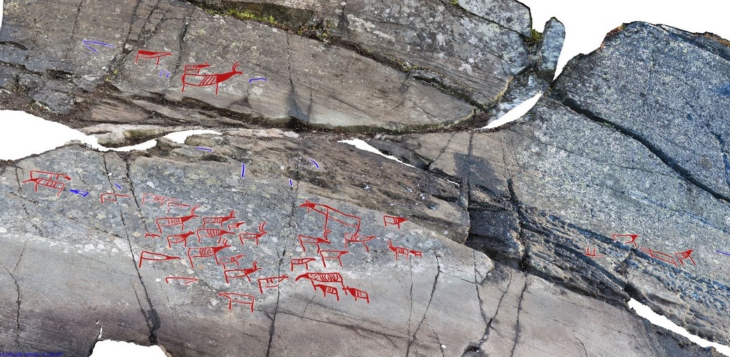
A report about a rock art site in Norway caught my attention recently. It is a petroglyph of a herd of reindeer. Now there is nothing unusual about a bundh of reindeer in petroglyphs in Scandinavia, this is a common theme, but they are usually portrayed with a number of other subjects as well. This panel shows a number of reindeer with a few moose as well. The unique thing about them is that they are almost all facing the same way as if the herd is on the move.

Migrating reindeer panel, Gamnes, Norway. Photograph Erik Kjellman, Tromsø Museum - The University Museum. 

Central portion of the panel enlarged. Photograph Erik Kjellman, Tromsø Museum - The University Museum. 

“Six to seven thousand years ago, the road system in Norway was essentially non-existent. That meant Stone Age residents mainly used waterways as they moved from place to place, especially on the hunt.

One area called Gamnes, located between the outlet of a river and the mouth of a fjord that opens onto the Barents Sea, is particularly rich with rock art. There are petroglyphs of reindeer and moose, in herds and alone, with and without young animals.” (Kvittingen 2016)


“In general, animals depicted in rock carvings are shown moving in all different directions. But in Gamnes, most of the reindeer have been drawn with their muzzles pointed in the same way. ‘The reindeer are following the fjord inland. This may mean that the artist was trying to depict a migration route,’ says Anja Roth Niemi, who is project manager for archaeological excavations for the University Museum in Tromsø, UiT – The Arctic University of Norway.” (Kvittingen 2016)

The map shows an estimate of where the sea level was when the petroglyphs were carved about 7,000 years ago. Under this scenario, the petroglyphs were right at sea level and were easily visible to those who paddled past. Image by Erik Kjellman, Tromsø Museum - The University Museum. The red dot at waterline shows the position of the petroglyph panel.

“These rock carvings are the only ones of their kind from the Stone Age in East Finnmark. The drawings were found last summer, and probably date from 5200-4200 BC. So far, scientists have tallied 48 figures, some of them incomplete, but they expect even more will become apparent when the lichen that covers the rock is removed.” (Kvittingen 2016)

Swimming reindeer crossing a river in Siberia. Internet photograph, public domain.

”The selection of subjects is not that varied, which is unusual. Petroglyphs from the same period in Alta, also in northern Norway, depict boats, bear, fish and hunting scenes. Here there are only reindeer and moose. Why would Stone Age people draw only these animals here?” (Kvittingen 2016)

One possibility is that the images represent a group of reindeer that have just emerged from the water. Reindeer are accomplished swimmers who cross bodies of water routinely. I would suggest that since this location is essentially surrounded on three sides by water it is likely that the reindeer shown all facing the same way are indeed migrating, but that they have just left the water and are heading inland. BTW – moose are good swimmers too.

NOTE: Some images in this posting were retrieved from the internet with a search for public domain photographs. If any of these images are not intended to be public domain, I apologize, and will happily provide the picture credits if the owner will contact me with them. For further information on these reports you should read the original report at the site listed below.

REFERENCE:

Kvittingen, Ida, translated by Nancy Bazilchuk, 2016, Stone Age artists used rock art as a billboard, 16 April 2016, https://sciencenorway.no/. Accessed online 5 July 2023.