Friday, December 23, 2016
Saturday, December 17, 2016
NEW ROCK ART DISCOVERIES IN JORDAN:
Petroglyphs found in
the
Black Desert of Jordan.
Photo:
Peter Akkermans.
A November 21, 2016, article on LiveScience, written by Owen
Jarus, covers the recording of "thousands
of inscriptions and petroglyphs dating back around 2,000 years - in the Jebel
Qurma region of Jordan's Black Desert." (Jarus 2016) The article
details discoveries by a team led by Peter Akkermans, of The Netherlands Leiden University, who leads a
study project at Jebel Qurma. "Nowadays,
the Jebel Qurma area, and the Black Desert in general, is a highly inhospitable
area, very arid and difficult to cross," said Akkermans.
Petroglyphs found in the
Black Desert of Jordan.
Photo: Peter Akkermans
Petroglyphs found in the
Black Desert of Jordan.
Photo: Peter Akkermans
"The inscriptions
are written in Safaitic, and alphabetic script used by people who lived in
parts of Syria, Jordan, and Arabia in ancient times." (Jaris 2016) The
team's discoveries show that the Jebel Qurma area had trees, wildlife, and a
large human population around 2,000 years ago.
Petroglyphs found in the
Black Desert of Jordan.
Photo: Peter Akkermans
Petroglyphs found in the
Black Desert of Jordan.
Photo: Peter Akkermans
"The petroglyphs,
or rock art, show images of lions, gazelles, horses, and large birds that may
be ostriches. The inscriptions found near these petroglyphs tend to be very
short. "Most of the texts are simply names, like so-and-so, the son of
so-and-so," Akkermans said. A
few inscriptions suggest that the population of Jebel Qurma had conflicts with
the people of the ancient city of Petra, the Nabataeans. (Jarus 2016)
Petroglyphs found in the
Black Desert of Jordan.
Photo: Peter Akkermans
"Other
inscriptions tell of the challenges and
setbacks encountered by the people who lived at Jebel Qurma. "May there be
strength against hunger," one inscription reads, while another was written
by a man who said he was 'distraught over his beloved.'" (Jarus 2016)
The changes in habitability indicated by the petroglyphs and
inscriptions should be seen in light of our present challenges caused by
climate change. If such major environmental changes can happen under natural
conditions in a relatively short time, under essentially natural conditions,
what kinds of changes can we expect in the relatively near future under conditions
of increasing global warming caused by human activities? Perhaps we should take
this as a serious warning.
Note: to see the full article visit LiveScience at http://wwwllivescience.com/56944-ancient-inscriptions-found-in-black-desert.html.
REFERENCE:
Jarus, Owen,
2016 Ancient
Inscriptions Show Life Once Flourished in Jordan's 'Black Desert', LiveScience, November 21, 2016, http://wwwllivescience.com/56944-ancient-inscriptions-found-in-black-desert.html.
Saturday, December 10, 2016
METEOROLOGICAL RECORDS IN ROCK ART - CHINESE CAVE INSCRIPTIONS:
Chinese drought inscription,
Davu Cave, Qinling mountains,
China. From Ghose, LiveScience,
August 20, 2015.
A subject
in rock art that has long fascinated me is evidence of verifiable events
recorded on the rocks. As everyone's daily life is directly impacted by
meteorology, that is one area that we should expect to find evidence of in rock
inscriptions or pictures. An example of this can be found in inscriptions in
Davu Cave, in southeastern China. Located in the Qinling Mountains, this cave
contains written inscriptions of droughts occurring in the region and their
impact upon the population.
Writing for
LiveScience on August 20, 2015, Tia Ghose cited an August 13 article from the
journal Scientific Reports that outlined a series of droughts in that area and
the inscriptions that record them. The droughts were confirmed by analysis of
chemical elements in stalagmites from the cave. Study co-author Sebastian
Breitenbach, a paleoclimatologist at the University of Cambridge, England
explained that the team analyzed the proportions of carbon, uranium, oxygen,
and other isotopes, in stalagmites to
detect climate changes over time that signaled droughts." The amounts of radioactive uranium and carbon, which decay at a
known rate, tied specific parts of the stalagmite to particular historic
times." (Ghose 2015) And, "because the water seeping into the
cave was likely groundwater, the levels of oxygen and carbon isotopes could
provide information about surface conditions outside the cave. The team found
that oxygen and carbon levels rose when rainfall was low, suggesting that those
markers could reliably reveal when drought conditions occurred."
(Ghose 2015)
Comparing
this scientific record then with cave inscriptions revealed a very accurate
correlation.
"One inscription, which is
dated to July 27, 1596, says directly that there is a big drought, and that the
writers had come to the cave to get water and pray for rain. Another, dating to
1891m reads: 'On May 24th, 17th year of the Emperor Guangxu period, Qing
Dynasty, the local mayor, Huaizong Shu, led more than 200 people into the cave
to get water. A fortune-teller named Zhenrong Ran prayed for rain during the
ceremony.'"
(Ghose 2015)
"Another inscription mentions a
Dragon Lake that may have been in the cave." (Ghose 2015)
All in all,
records of seven droughts over the past 500 years corresponded quite well with
the recorded droughts in the cave formations. The team even used their data
from the chemical record and the inscriptions to construct a model to predict
future periods of drought in that region. That model predicts that "in the next decade, China is in for
more severe and more frequent droughts, though the model can't predict exactly
where or when the droughts will occur." (Ghose 2015)
Rock art,
not only as a record of the past, but as a predictor of the future. How about
that?
REFERENCES:
http://www.livescience.com/51929-cave-graffiti-reveals-drought.html
Labels:
Chinese,
drought,
inscription,
meteorology,
pictographs,
rock art
Saturday, December 3, 2016
MYTHOLOGY IN ROCK ART:
We have long been convinced that mythology could offer insights into the meaning of rock art. I am sure that we all know of examples where we are convinced that this works, that the meaning of a rock art panel can be inferred by knowledge of the mythology of the people who created it. Now an article in the December 2016 issue of Scientific American makes the fascinating claim that mythology can be used to decipher meaning in cave art produced during the Paleolithic period.
Julien d'Huy, in The Evolution of Myths, explains his process of phylogenetic analysis using statistics to generate "phylogenetic trees (that) reveal that species of myths evolve slowly and parallel patterns of mass human migration out of Africa and around the globe." (d'Huy 2016:64)
D'Huy explained that "my phylogenetic studies make use of the extra rigor of statistical and computer modeling techniques from biology to elucidate how and why myths and folktales evolve." (d'Huy 2016:64)
One of the myth families that he has applied this technique to is the "Cosmic Hunt", where "a man or an animal pursues or kills one or more animals and the creatures are changed into constellations." (d'Huy 2016:64) This story, in a number of variations, was common to the ancient Greeks in the story of Callisto who becomes the constellation Ursa Major, the great bear, and to the Iroquois, Chukchi, and Finno-Ugric tribes of Siberia. According to d'Huy "although the animals and the constellations may differ, the basic structure of the story does not." (d'Huy 2016:64)
D'Huy has traced the Cosmic Hunt myth back through history and around the world. He found it to be "nearly absent in Indonesia and New Guinea an very rare in Australia, but present on both sides of the Bering Strait, which geologic and archaeological evidence indicates was above water between 28,000 and 13,000 B.C. The most credible working hypothesis is that Eurasian ancestors of the first Americans brought the family of myths with them." (d'Huy 2016:65)
Another myth family that d'Huy has traced back to early origins is known as the Polyphemus myth after the one-eyed giant in the Odyssey who trapped Ulysses' crew in a cave and devoured some of them. In the same way as Polyphemus kept his herd of sheep in a cave, in variations of this myth animals are kept concealed by a trickster or other being, and a hero bring them to the surface of earth to sustain the people. The Algonquin Blackfoot people acquired buffalo in this way. "A composite phylogenetic tree of Polyphemus myths indicates that the stories followed two major migratory patterns: The first, in Paleolithic times spread the myth in Europe and North America. The second, in Neolithic times, paralleled the proliferation of livestock farming." (d'Huy 2016:68)
"Phylogenetic reconstructions of both the Polyphemus and Cosmic Hunt stories build on decades of research by scholars who based their work primarily on oral and written versions of folktales and legends. The current models also incorporate empirical observations of mythological motifs in prehistoric rock art. Similarities in certain rock art motifs and the reconstructed stories open a new window on the mental universe of the first humans who migrated across the Bering Strait to the New World between 30,000 and 15,000 years ago.
In the myth of Polyphemus, as its original public most likely heard it, a hunter faces one or many monsters that possess a herd of wild animals. He enters the place where the monster keeps the animals and finds his way out blocked by a large obstacle. The monster tries to kill him. The hero manages to escape by clinging to the underbelly of one of the animals.
This protomyth - revealed by three separate phylogenetic databases, many statistical methods and independent ethnological data - reflects the belief, widely held by ancient cultures, in the existence of a master of animals who keeps them in a cave and the need for an intermediary to free them." (d'Huy 2016:69)
D'Huy believes that this theme to can be applied to the Paleolithic world view on the origin of game. "At the Cave of the Trois-Freres (or "three brothers")
in the French Pyrenees, frequented during the upper Paleolithic, a panel shows a small creature with the head of a bison and the body of a human, which seems to be holding a short bow. Lost in the middle of a herd of bison, another animal, similar to a bison, turns its head toward the human hybrid, and the two exchange gazes." (d'Huy 2016:69)
This, he sees as an illustration of the herd of game animals being brought out of concealment (hidden in the cave perhaps) by a hero, to the people.
Now I have been relatively critical of statistical analysis in the past, especially when applied to rock art, but even without relying on statistics this explanation makes a great deal of sense, and when combined with the phylogenetic analysis of the mythology, I have to concede that I believe there is something here that is possibly of great importance to rock art studies. I look forward in the future to more contributions by Julien d'Huy.
NOTE: Read the whole article in the December 2016 Scientific American magazine.
REFERENCE:
Julien d'Huy,
2016 The Evolution of Myths, Scientific American, December 2016, Volume 315, Number 6, pages 62 - 69.
Saturday, November 19, 2016
VANDALIZED BY MOTHER NATURE - CHINESE ROCK ART DESTROYED BY FLOODING:
Flood damage upon chinese rock
art, Helan Mountain, Ningxia
Autonomous Region, China.
http://www.archaeology.org/news?page=2
A recent
story on www.archaeolgy.org reported considerable damage to rock art on cliffs
of Helan Mountain in the Ningxia Autonomous Region of northwest China by heavy
rains and flooding. "China.org.cn reports that rare flooding in the Ningxia Hui
Autonomous Region of northwest China has damaged some of the thousands of
prehistoric carvings on the cliffs of Helan Mountain. The images are thought to
have been created by nomads who lived in the area between 3,000 and 10,000
years ago. Some of the images were damaged by mud and silt, and about a dozen
images that had been carved on individual rocks were carried away by the flood
waters. Other pictures were lost when layers of mountain rock peeled off or
cracked in the heavy rains. Hu Zhiping, deputy director of the Helan Mountain
Cliff Painting Administration, said that the extent of the damage is still being
assessed." (www.archaeology.org 2016:2)
Helan
Mountain was decorated with an estimated 20,000 examples of rock art scattered
over several hundred kilometers. These had been created by nomadic tribes once
living in the area and are believed to be between 3,000 and 10,000 years in
age. "An
employee at the scenic area which has about 6,000 cliff paintings, said about a
dozen paintings on individual rocks were unaccounted for." (www.archaeology.org 2016:2)
This is
another reminder of the ephemeral nature of much rock art. This statement may
seem counterintuitive when we are discussing an art form that depends upon
solid rock for its medium, but you can visit museums all over the world that
are full of ancient works of art that are in better condition than the contents
of many rock art sites that are younger in age than those works of art in the museums.
The morale of this story is that is
still critical that we fully record all rock art so that digital records may be
protected for the future.
REFERENCE:
http://www.archaeology.org/news?page=2
http://www.china.org.cn/china/2016-08/26/content_39169375.htm
Labels:
China,
flood damage,
petroglyphs,
rock art,
vandalism
Saturday, November 12, 2016
A NAVAJO ROCK ART SITE IN THE CENTRAL COLORADO MOUNTAINS?
Almont rock art site, CO.
Photo, Jared Allen, 2016.
I recently
received some fascinating pictures and information from Jared Allen. Jared
shared some photographs of a rock art site near Almont, in Gunnison County,
Colorado. A couple of the photos show deeply incised grooves or the sort
usually defined as tool sharpening grooves, although some of the grooves appear
to be arranged purposefully to create a tree-like image. Much more interesting,
however, are a couple of Jared's photographs that illustrate what appear to be
Navajo Yei (Holy People) figures. Almont is a considerable distance from the
current region of Navajo habitation, so what gives here?
Almont rock art site, CO.
Photo, Jared Allen, 2016.
Almont,
Colorado, is approximately 9 miles north of the town of Gunnison, and 60 miles
NW of Saguache. Some references place the early Navajo and the boundaries of
Dinetah, the Navajo homeland, far enough north and east of their present
territory that it includes the San Luis Valley in south/central Colorado. "Dinétah
encompasses a large area of northwestern New Mexico, southwestern Colorado, southeastern Utah, and northeastern Arizona. The boundaries are inexact, and are generally marked by mountain peks which correspond to the four cardinal directions." (Wikipedia) Indeed, Mount
Blanca, one of the Navajo four holy mountains is located in the Sangre de
Cristo mountain range on the east side of the San Luis Valley.
Almont rock art site, CO.
Recurved bow held by
figure on the right.
Recurved bow held by
figure on the right.
Photo, Jared Allen, 2016.
The right figure in this group appears to be holding a recurved bow considered a hallmark of athapaskan peoples and, thus, a possible Navajo identifier (see below).
Yei pictographs showing recurved
bow, Delgadito Canyon. Picture
from www.nm.blm.gov/.
bow, Delgadito Canyon. Picture
from www.nm.blm.gov/.
"In Navajo tradition, the Holy People, or Yeis, are sometimes shown holding "recurved" bows. This technological innovation is thought by some to have been introduced by the ancestors of today's Navajo and Apache. The distinctive double curve is sometimes shown alone as a symbol for Naayee' Neizghani, or Monster Slayer, one of the Hero Twins." (www.nm.blm.gov/)
If these images are indeed Navajo in origin they are probably dated from back early in the athapaskan entrance into this area, as with the passage of time the Navajo gravitated farther south and west. "The Navajo occupation of the region has been divided into two major phases - the Dinetah phase (ca. 1500-1630, which includes the entrance and settling of the area by the Navajo, and the Gobernador phase (ca. 1630-1800), during which time the Navajo culture became fully defined." (Wikipedia)
So, if
these Navajo figures are authentic, they are probably fairly early, or evidence
of a later wanderer.
REFERENCES:
http://www.nm.blm.gov/features/dinetah/navajo_history_2.html
Wikipedia
Labels:
Colorado,
Navajo,
petroglyphs,
pictographs,
rock art,
Tool grooves
Saturday, November 5, 2016
DINOSAUR TRACKS ON THE LINTEL BUILT INTO AN ANCESTRAL PUEBLO DWELLING:
I have written elsewhere about the fact that when I was an undergraduate the field of Art History also included studying architecture and design/decoration. I do not see so much of that these days but, as for me, both architecture and design/decoration are legitimate branches of Art History and thus are eligible for inclusion here in RockArtBlog. The following combines both in an example of an Ancestral Puebloan structure in Utah.
Lintel over doorway, Ancestral Pueblo.
Photograph: Joshua Smith.
Humans are fascinated by fossils. This was as true for our early ancestors as it is for us. On October 6th, 2016, I had the pleasure of meeting and talking with Joshua Smith, a contract paleontologist in Grand Junction, Colorado. We met at his favorite coffee shop and I had an excellent breakfast burrito and a cup of good coffee while we talked about Native American fossil knowledge. Smith showed me photographs of one of his discoveries, an instance of incorporation of fossil dinosaur footprints into the architecture of an ancestral puebloan building in Utah.
View of the underside of the lintel,
Ancestral Pueblo. Photograph:
Joshua Smith.
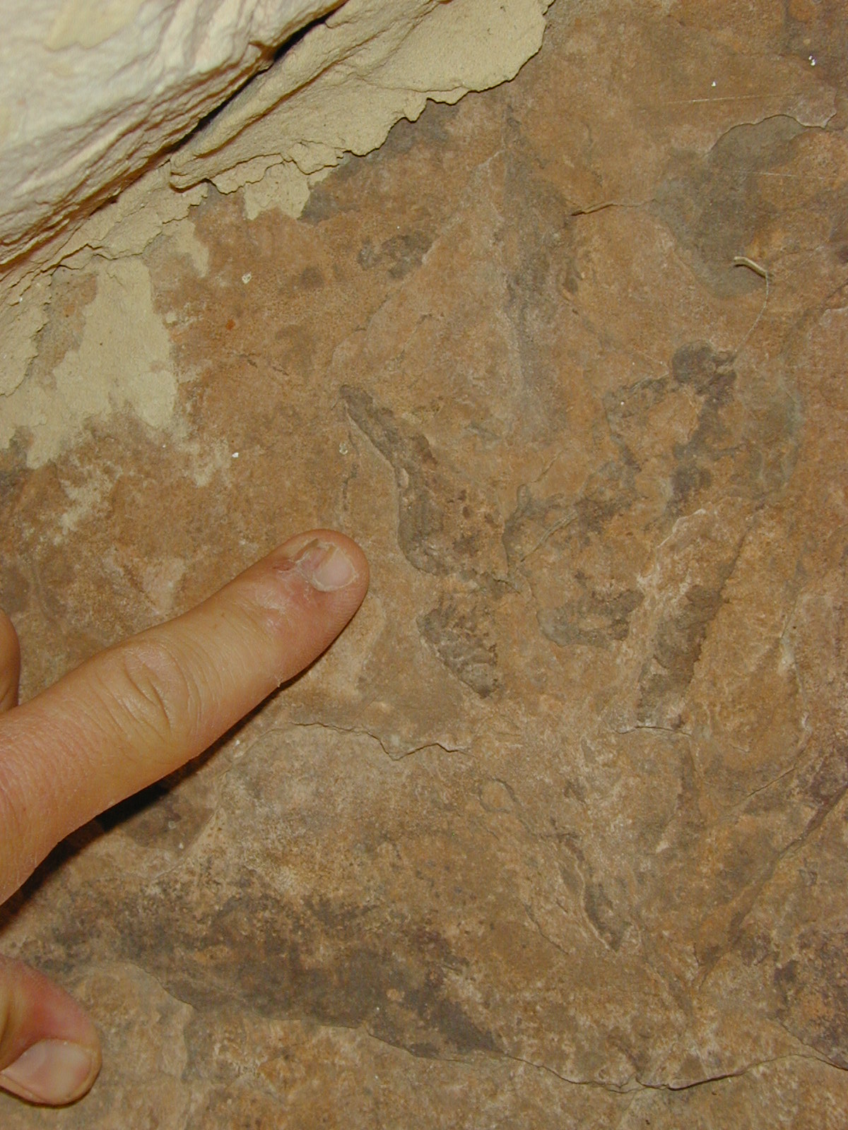
Smith first noticed them in 2003. While the building had long been known to archaeologists, apparently no one had noticed the tracks on the underside of the lintel over the doorway until Smith came along (an good example of we see what we expect to see, and an excellent reason for cross-disciplinary studies in rock art).
Pointing out one track on
the lintel, Ancestral Pueblo.
Photograph: Joshua Smith.
Some of the structure is dated from Basketmaker II, AD 50 - 500 (Wikipedia), but most of the construction appears to date from the Pueblo III period, AD 1150 - 1350 (Wikipedia). While the structure is constructed of cream-colored sandstone from nearby, the pinkish-colored sandstone of the lintel stood out as coming from a different source, although also local. In examining it Smith found the two dinosaur tracks on the underside where they were exposed to view. This may be important as the stone could have just as well been placed with the tracks on the upper side hidden from view. This suggests that they were purposely left so they could be viewed, and that they had some significance to the builders and occupants of the structure (Smith 2016).
Pointing out one track on
the lintel, Ancestral Pueblo.
Photograph: Joshua Smith.
Dinosaur tracks are classified into separate ichnospecies from dinosaur remains because they often cannot be pinned down to the exact species that made them. These tracks fall into the category known as Grallator. "Grallator tracks are characteristically three-toed (tridactyl) and range from 5 to 15 centimeters (or 2 to 6 inches) long. While it is usually impossible to match these prints with the exact dinosaur species that left them, it is sometimes possible to narrow down potential trackmakers by comparing the proportions in individual Grallator ichnospecies with known dinosaurs of the same formation." (Wikipedia)
Outlined track on the lintel, Ancestral
Pueblo. Photograph: Joshua Smith.
Smith identified the tracks as belonging to a small theropod dinosaur, similar to a coelophysis, based upon his knowledge of the age of the rock formation and the species extant in that time. (Smith 2016) Previously, I have written about Native American knowledge of fossil tracksites and cited a Navajo example identifying them as "giant lizard footprints". (Faris 2011) Whether the tracks had a spiritual value to the builder, or were just included for decorative purposes, this important discovery not only adds another example of Native American fossil knowledge, it provides evidence of another facet of their beliefs and material culture in which this knowledge could be expressed. Thank you Josh.
REFERENCES:
Faris, Peter
2011 Dinosaur Footprints and the Giant Lizard Petroglyphs at Cub Creek, Dinosaur National Monument, Feb. 9, 2011,
http://rockartblog.blogspot.com.
Smith, Joshua, personal communication, 2016.
Wikipedia
Labels:
Anasazi,
architecture,
decoration,
fossil tracks
Subscribe to:
Posts (Atom)