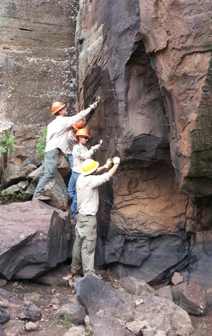
Photo Rafael Platas Ruiz, INAH, Colima, Mexico.
One claim
that occurs frequently in rock art interpretation is that a particular design
represents a map. In the past I have argued that this is unlikely in North
America for a few reasons.
1. These
were oral societies who, before contact, passed information on by word of
mouth, not writing.
2. They did
not have any use for a map. They already knew every square inch of their
territory and where every resource could be found, as well as we know our back
yards and the local grocery store. These are tribal people living within a
territory that they know as well as the back of their hand.
3. A
permanent map carved into the rock could be of help to possibly hostile outside
groups and raiders.
Even though
many of my friends and co-researchers believe claims that many North American
examples do represent maps (how many map rocks have you seen?) I am still very
skeptical about claims for maps in North American rock art.
I have
visited many sites with rock art panels that local "experts" identify
as a map, and I have yet to find one in North America that I can accept, but,
there are situations and places where rock art maps might actually be found.
Photo INAH, Colima, Mexico.
Now we have
a report out of Mexico of a carved boulder that has been identified as a map. "Archaeologists from the Instituto
Nacional de Antropologia e Historis (INAH) have announced the discovery of a
stone map that dates from between 200 BC and AD 200 in Colima, Mexico. The map
represents the territory of Pre-Columbian natives living around Colima (evident
by small circular features that shows the position of ancient settlements),
that was carved on a basalt volcanic rock deposited in situ after being thrown
from an ancient eruption at the Colima volcano some 14 km away. The stone,
measures 1.7 metres in height and sits on an axis of approximately 20° to the northeast and is orientated towards
the volcano." (heritagedaily.com 2020) In other words this large lava
boulder is a volcanic bomb that was thrown 8 miles from the volcano to its
present position.
"In a statement INAH said that
the stone is oriented with its main surface facing the Fuego de Colima volcano
'and it has cavities that could represent villages, as well as lines associated
with waterways and geographical features'." (LaPrensa 2020) According to the
head of INAH, Julio Ignacio Martinez de la Rosa, "the identification of the map is based on a study of the designs
and patterns as well as a comparison to similar petroglyphs found in the
region. The stone has carved hollows that represent villages, as well as lines
that can be association with natural orographic and hydrological features.
Inspection of the map has been conducted by Archaeologist Rafael Platas Ruiz
who has found that some features also correspond with the geographical
landscape of the southern slope of the Colima volcano, with ravines and rivers
clearly apparent." (Heritagedaily 2020) With the boulder located 8 miles
(14km) from the volcano, and with details of the volcano's southern slope
included in its carving, the map must depict an area more than 8 miles across
in one dimension, quite a large endeavor.

Photo Rafael Platas Ruiz, INAH, Colima, Mexico.
"Colima is a small state of
Western Mexico on the central Pacific coast, and includes the four oceanic
Revillagigedo Islands. Mainland Colima borders with the states of Jalisco and
Michoacan."
(Wikipedia)
"Archaeologist Rafael Platas
Ruiz, the official in charge of examining cultural heritage items, said that
the stone features 'at least three carving techniques - polishing, chipping and
sanding - which were used to represent the surrounding landscape in various
ways'." (La
Prensa 2020)
Ruiz stated
"the stone is not associated with
the Chanal phase. Its designs and workmanship techniques have a greater
relationship with the . . . period from 200 BC to 200 AD - that is, the period
between the Late Preclassical and Early Classic periods". (La Prensa
2020)
These dates
would lakely place it in the Los Ortices
era which began around 1500 BCE, and preceded the Comala phase from 100 to 600 CE which featured the burnished red
pottery figures of people and fattened dogs known so well today. (Wikipedia)
Fig. 7a, p. 66, page from Codex Boturini, departure from Aztlan on the date '1 flint'. From Helmke, Nielsen, and Guzman.
And again, "Archaeologists determined that the
context dating doesn't correspond with the Chanal or Postclassic Colimense
phase (1000-1500 AD) and instead (has) drawn comparisons to early tombs from
the Late Preclassic and Early Classic periods
between 200 BC and AD 200." (Heritagedaily)
Fig.4, p. 62, First page of Codex Zolotl, map of Valley of Mexico. From Helmke, Nielsen, and Guzman.
Fig. 3, p. 60, Historia Tolteca-Chichimeca, map of Quauhtunchan city state in Puebla, Mexico. From Helmke, Nielsen, and Guzman.
In this instance I am much
more inclined to accept the interpretation of the petroglyphic design as a map.
These were not hunting/gathering cultures surviving within and off of the
landscape, they were authoritarian cultures with political boundaries,
depending on resources located within their territories, collection of taxes
from their populations, and profiting from trade (and sometimes conflict) with
other polities. It makes much more sense to me that they would have use for a
map for planning purposes and keeping accurate records. Indeed, we know from
surviving codices and murals that many of the civilizations of Mexico had
cartographic traditions.
Although these Mexican
examples are, in fact, illustrating an event while showing details of where it
occurred, these details just as surely constitute a map record as our much more
general mapping tradition.
Previous
postings on the subject of maps on RockArtBlog include:
1. April
18, 2009, Are There Maps In Native
American Rock Art?
2. August
17, 2013, Maps in Rock Art - 3-D Carved
Maps.
3. March
12, 2016, Maps In Rock Art - Revisited.
4. March 9,
2019, Are These Ute Wooden Maps? - or
Apophenia/Pareidolia/Mimetoliths/Manuports.
NOTE:
Some images in this posting were retrieved from the internet with a search for
public domain photographs. If any of these images are not intended to be public
domain, I apologize, and will happily provide the picture credits if the owner
will contact me with them. For further information on these reports you should
read the original reports at the sites listed below.
REFERENCES:
Helmke,
Christopher, Jesper Nielsen Angel Ivan Rivera Guzman
2019 The
Origins and Development of the Cartographic Tradition in the Central Mexican
Highlands, Contributions in New World Archaeology, Vol. 12, Polish Academy
of Arts and Sciences and Jagiellonian University Institute of Archaeology,
Krakow, Poland.
https://www.heritagedaily.com/2020/06/archaeologists-discover-2000-year-old-stone-map-on-volcanic-rock/133727
https://wikipedia.org/wiki/Colima
Online News
Editor
2020 Mexico
Registers Petrogyph Used as Stone-Map Some 2,000 Years Ago, June 14, 2020,
La Prensa,
https://www.laprensalatina.com/mexico-registers-petroglyph-used-as-stone-map-some-2000-years-ago/