Saturday, July 11, 2020

CORPORATE GREED AND VANDALISM - RIO TINTO CORPORATION BLOWS UP SACRED PILBARA SITES:

 This cave in the Juukan Gorge, dubbed Juukan 2, was destroyed in a mining blast. Photograph: The Puutu Kunti Kurrama and Pinikura Aboriginal Corporation.


In a stunning example of corporate greed and total lack of sensitivity, not only to ethnic sensibility, but to scientific value, the Rio Tinto Mining Corporation blew up rock shelters bearing evidence of 46,000 years of occupation in Australia's Pilbara region.

"A sacred site in Western Australia that showed 46,000 years of continual occupation and provided a 4,000-year-old genetic link to the present-day traditional owners has been destroyed in the expansion of an iron ore mine. The cave in Juukan Gorge i the Hammersley Ranges, about 60km from Mt. Tom Price, is one of the oldest in the western Pilbara region and the only inland site in Australia to show signs of continual human occupation through the last Ice Age. it was blasted along with another sacred site on Sunday. Mining company Rio Tinto received ministerial consent to destroy or damage the site in 2013 under WA's outdated Aboriginal heritage laws, which were drafted in 1972 to favour mining proponents. One year after consent was granted, an archaeological dig intended to salvage whatever could be saved discovered the site was more than twice as old as previously thought and rich in artefacts, including sacred objects." (Wahlquist 2020)

Juukan 2, after the blast. Photograph: The Puutu Kunti Kurrama and Pinikura Aboriginal Corporation.


According to current understanding "The Aboriginal population of the Pilbara considerably predates, by 30-40,000 years, the European colonisation of the region. Archaeological evidence indicates that people were living in the Pilbara even during the harsh climatic conditions of the Last Glacial Maximum. The early history of the first peoples is held within an oral tradtition, archaeological evidence, and petroglyphs. Near the town of Dampier is a peninsula known as Murujuga, which contains a large collection of world heritage listed petroglyphs, dating back thousands of years. Rock art in the Pilbara appears to have been primarily etched into the hard rock surfaces, compared to predominantly paintings on the softer sandstone of the Kimberley. This does not preclude that painting was and is not performed in the Pilbara. In 2006, it was estimated that 15% of the population of the Pilbara was of indigenous background, approximately 6,000 people." (Wikipedia)

While I have been unable to determine whether any Aboriginal rock art was actually destroyed along with the caves, it is hard to believe that there were no graphic images or markings remaining from 46,000 years of occupation. In any case they were important archeological sites as well as important examples of cultural heritage, and their destruction illustrates the mindless ignorance of corporate profiteering. 


REFERENCES:

https://en.wikipedia.org/wiki/Pilbara


Wahlquist, Calla

2020 Rio Tinto Blasts 46,000-year-old Aboriginal Site to Expand Iron Ore Mine, May 25, 2020, the Guardian, Manchester, England.


Friday, July 10, 2020

A SUPPOSED STONE MAP PETROGLYPH IN MEXICO:


Photo  Rafael Platas Ruiz, INAH, Colima, Mexico.

One claim that occurs frequently in rock art interpretation is that a particular design represents a map. In the past I have argued that this is unlikely in North America for a few reasons.

1. These were oral societies who, before contact, passed information on by word of mouth, not writing.

2. They did not have any use for a map. They already knew every square inch of their territory and where every resource could be found, as well as we know our back yards and the local grocery store. These are tribal people living within a territory that they know as well as the back of their hand.

3. A permanent map carved into the rock could be of help to possibly hostile outside groups and raiders.


Even though many of my friends and co-researchers believe claims that many North American examples do represent maps (how many map rocks have you seen?) I am still very skeptical about claims for maps in North American rock art.

I have visited many sites with rock art panels that local "experts" identify as a map, and I have yet to find one in North America that I can accept, but, there are situations and places where rock art maps might actually be found.


Photo INAH, Colima, Mexico.

Now we have a report out of Mexico of a carved boulder that has been identified as a map. "Archaeologists from the Instituto Nacional de Antropologia e Historis (INAH) have announced the discovery of a stone map that dates from between 200 BC and AD 200 in Colima, Mexico. The map represents the territory of Pre-Columbian natives living around Colima (evident by small circular features that shows the position of ancient settlements), that was carved on a basalt volcanic rock deposited in situ after being thrown from an ancient eruption at the Colima volcano some 14 km away. The stone, measures 1.7 metres in height and sits on an axis of approximately 20° to the northeast and is orientated towards the volcano." (heritagedaily.com 2020) In other words this large lava boulder is a volcanic bomb that was thrown 8 miles from the volcano to its present position.

"In a statement INAH said that the stone is oriented with its main surface facing the Fuego de Colima volcano 'and it has cavities that could represent villages, as well as lines associated with waterways and geographical features'." (LaPrensa 2020) According to the head of INAH, Julio Ignacio Martinez de la Rosa, "the identification of the map is based on a study of the designs and patterns as well as a comparison to similar petroglyphs found in the region. The stone has carved hollows that represent villages, as well as lines that can be association with natural orographic and hydrological features. Inspection of the map has been conducted by Archaeologist Rafael Platas Ruiz who has found that some features also correspond with the geographical landscape of the southern slope of the Colima volcano, with ravines and rivers clearly apparent." (Heritagedaily 2020) With the boulder located 8 miles (14km) from the volcano, and with details of the volcano's southern slope included in its carving, the map must depict an area more than 8 miles across in one dimension, quite a large endeavor.


Photo Rafael Platas Ruiz, INAH, Colima, Mexico. 

"Colima is a small state of Western Mexico on the central Pacific coast, and includes the four oceanic Revillagigedo Islands. Mainland Colima borders with the states of Jalisco and Michoacan." (Wikipedia)

"Archaeologist Rafael Platas Ruiz, the official in charge of examining cultural heritage items, said that the stone features 'at least three carving techniques - polishing, chipping and sanding - which were used to represent the surrounding landscape in various ways'." (La Prensa 2020)

Ruiz stated "the stone is not associated with the Chanal phase. Its designs and workmanship techniques have a greater relationship with the . . . period from 200 BC to 200 AD - that is, the period between the Late Preclassical and Early Classic periods". (La Prensa 2020)

These dates would lakely place it in the Los Ortices era which began around 1500 BCE, and preceded the Comala phase from 100 to 600 CE which featured the burnished red pottery figures of people and fattened dogs known so well today. (Wikipedia)


Fig. 7a, p. 66, page from Codex Boturini, departure from Aztlan on the date '1 flint'. From Helmke, Nielsen, and Guzman.

And again, "Archaeologists determined that the context dating doesn't correspond with the Chanal or Postclassic Colimense phase (1000-1500 AD) and instead (has) drawn comparisons to early tombs from the Late Preclassic and Early Classic periods  between 200 BC and AD 200." (Heritagedaily)


Fig.4, p. 62, First page of Codex Zolotl, map of Valley of Mexico. From Helmke, Nielsen, and Guzman.

Fig. 3, p. 60, Historia Tolteca-Chichimeca, map of Quauhtunchan city state in Puebla, Mexico. From Helmke, Nielsen, and Guzman.

In this instance I am much more inclined to accept the interpretation of the petroglyphic design as a map. These were not hunting/gathering cultures surviving within and off of the landscape, they were authoritarian cultures with political boundaries, depending on resources located within their territories, collection of taxes from their populations, and profiting from trade (and sometimes conflict) with other polities. It makes much more sense to me that they would have use for a map for planning purposes and keeping accurate records. Indeed, we know from surviving codices and murals that many of the civilizations of Mexico had cartographic traditions.


Although these Mexican examples are, in fact, illustrating an event while showing details of where it occurred, these details just as surely constitute a map record as our much more general mapping tradition.

Previous postings on the subject of maps on RockArtBlog include:

1. April 18, 2009, Are There Maps In Native American Rock Art?

2. August 17, 2013, Maps in Rock Art - 3-D Carved Maps.

3. March 12, 2016, Maps In Rock Art - Revisited.

4. March 9, 2019, Are These Ute Wooden Maps? - or Apophenia/Pareidolia/Mimetoliths/Manuports.

NOTE: Some images in this posting were retrieved from the internet with a search for public domain photographs. If any of these images are not intended to be public domain, I apologize, and will happily provide the picture credits if the owner will contact me with them. For further information on these reports you should read the original reports at the sites listed below.

REFERENCES:

Helmke, Christopher, Jesper Nielsen Angel Ivan Rivera Guzman

2019 The Origins and Development of the Cartographic Tradition in the Central Mexican Highlands, Contributions in New World Archaeology, Vol. 12, Polish Academy of Arts and Sciences and Jagiellonian University Institute of Archaeology, Krakow, Poland.

https://www.heritagedaily.com/2020/06/archaeologists-discover-2000-year-old-stone-map-on-volcanic-rock/133727

https://wikipedia.org/wiki/Colima

Online News Editor

2020 Mexico Registers Petrogyph Used as Stone-Map Some 2,000 Years Ago, June 14, 2020, La Prensa, https://www.laprensalatina.com/mexico-registers-petroglyph-used-as-stone-map-some-2000-years-ago/


Saturday, July 4, 2020

ROCK ART DAMAGED BY FIRE IN QUEENSLAND, AUSTRALIA:

Australia's Baloon Cave rock art site viewing platform before the fire. Internet photo: public domain.


A popular Australian rock art tourist destination, Baloon Cave in Carnarvon Gorge, Queensland, Australia, was destroyed by fire in late 2018. An article by Paul Taçon for the Bradshaw Foundation's Rock Art Network outlines how efforts to protect this rock art destination actually led to its destruction.


"Aboriginal Australians maintain powerful connections to rock art sites and argue that these heritage places are a part of living culture. Moreover, most indigenous Australians desire to share their heritage with the wider world and over 100 rock art sites are open for guided or unescorted visitation. But infrastructure and resources vary widely and rarely do sites have conservation and/or management plans." (Taçon 2019)

Baloon Cave before and after the fire. Internet photo: public domain.

One site that allows public visitation is Baloon Cave, "located in Carnarvon Gorge, central Queensland, Australia. It was one of the four rock art sites open to the public for visitation in Carnarvon Gorge and the closest to the visitor area and ranger station. It is known for its sets of stenciled hands and a series of hafted stone axe stencils. Initially access to Baloon Cave was via a stone and soil walking track, with low handrails separating visitors from the art panels. However, some vandalism occurred with lines and letters scratched over and into stencils.

To facilitate better access and to better protect the rock art a large viewing platform and walkway was installed at Baloon Cave in 2014. REPLAS Enduroplank recycled plastic products were used with composite fibre structural components. On the REPLAS website the Enduroplank is promoted as a low maintenance endurable material suitable for Baloon Cave." (Taçon 2019)

Baloon Cave rock art panel before the fire. Internet photo: public domain.


"ABC Australia reports that ancient rock art at eastern Australia's Carnarvon National Park was destroyed in 2018 when a walkway made of recycled plastic exploded during a brushfire. 'Unfortunately, that's sort of like solidified petroleum, and if you have a hot fire underneath it, it melts and then it just explodes into a ball of flame and that's exactly what happened,' said Paul Taçon of Griffith University. Pieces of rock sloughed off Baloon Cave's walls, along with the artwork which included ancient handprints and more recent  images. Dale Harding, a member of the Baloon Cave working group, called the lost artwork a link between generations of Bidjara, Ghungalu, and Garingbal people." (Wikipedia)

This product is apparently touted as fire retardant but experience is proving otherwise. Brushfires reportedly also ignited Enduroplank structures at two other locations in addition to Baloon Cave.

Baloon Cave rock art panel after the fire. Internet photo: public domain.

The rock art at Baloon Cave was seriously impacted.

"Damage to the main panel consists of exfoliation to the left, right and above right, cracking at the upper right, and a coating of soot over most of the stencilled hands and all of the hafted axe stencils. As one approaches the panel, it first appears it is completely blackened but closer inspection and photography with the light at the right angle reveals the stencils underneath." (Taçon 2019)

"Damage to the rare hafted stone axe stencils is pronounced as not only have they been blackened but also where two of them are located the rock has both cracked and exfoliated. The cracked portion at the left looks as if it could easily collapse. It may be possible to remove the soot and to consolidate the panel but this needs further investigation and assessment. Some soot has washed away in recent heavy rain. There is a risk that the rock above the major new crack could sheer off and fall to the ground, taking portions of the stencils with it." (Taçon 2019)

Although he acknowledged that non-flammable construction would possibly be more expensive "Taçon suggested that only steel, or concrete and steel, but used to construct walkways at Australia's cultural heritage sites." (Wikipedia)


This should be a lesson to us all concerned with the protection of rock art.


NOTE: Some images in this posting were retrieved from the internet with a search for public domain photographs. If any of these images are not intended to be public domain, I apologize, and will happily provide the picture credits if the owner will contact me with them. For further information on these reports you should read the original reports at the sites listed below.

REFERENCES:

https://www.archaeology.org/news?page=1


Taçon, Paul

2019 The Aftermath of Fire Damage to Important Rock Art at the Baloon Cave Tourist Destination, Carnarvon Gorge, Queensland, Australia, 24 November 2019, Rock Art Network, www.bradshawfoundation.com.


Saturday, June 27, 2020

KEYHOLE SINK, KAIBAB NATIONAL FOREST, AZ. - ANOTHER RESTORATION:


Keyhole Sink, Kaibab National Forest. Photo Kaibab National Forest.


Keyhole Sink panel. Photo Kaibab National Forest.

A sad incident of vandalism occurred at Keyhole Sink, in Arizona's Kaibab national Forest occurred in August 2010. Some hero (or heroes) with a can of silvery-white paint added their work to a petroglyph panel. 


Keyhole Sink panel vandalized. Forest. Photo Kaibab National Forest. 

"Keyhole Sink is a canyon in the shape of a keyhole near Williams, Arizona. The canyon is best known for its petroglyphs, which were created about 1,000 years ago by the Cohonina people, and the seasonal waterfalls that flow into the canyon." (Wikipedia)


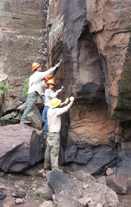
Restoration crew with wire brushes. Photo Kaibab National Forest.

In November, 2010, a team of National Forest personnel led by rock art restorer Johannes Loubser and Kaibab National Forest archaeologist Neil Weintraub performed a restoration on the panel. Several materials and techniques were tested before they decided on their final strategy.


Restoration crew with butane torch and Munsell chart. Photo Kaibab National Forest.

According to Weintraub "for thousands of years and for thousands of visitors - both recent and prehistoric - Keyhole Sink was a serene place to make a connection with nature and the past. I feel that all changed in late August when someone decided to hike in three-quarters of a mile to the petroglyph panel with a bucket of paint." (Banks 2010)


Restoration crew spraying Elephant Snot.
Photo Kaibab National Forest.

The process that they used to remove the paint involved both chemicals and heat. The paint used was an aluminum roofing cement and much of that could be removed from the background rock surface (not the petroglyphs proper) with butane torches. Within the lines of the petroglyphs the butane torches were used to heat "very fine steel brushes just enough to get the brush to help us peel back the paint." (Weintraub 2019)

Keyhole Sink panel after restoration restoration.
Photo Kaibab National Forest.

Remaining traces were removed with a biodegradable cleanser marketed under the name of Elephant Snot. "In 2013, we used our Youth Conservation Corps crew of local high school students to use 'Elephant Snot' to clean up the mess created by the vandals. It worked beautifully and visitors can no longer tell that the site was vandalized. 'Elephant Snot' is a biodegradable cleanser that works on certain paint materials better than others. We have had great success with it, especially in our volcanic landscape." (Weintraub 2019)

I am pleased to note another successful rock art restoration, as well as the materials and techniques used in this endeavor. Another marvelous job.

NOTE: The images in this posting were provided by the Kaibab National Forest. I wish to thank South Kaibab Zone archaeologist Neil Weintraub for his cooperation with RockArtBlog in providing this information, and for the good work of restoring this site. For further information on these reports you should read the original reports at the sites listed below.
NOTE: The weird effects in some type are the result of changes Blogger has made in their style and formatting. As they do not have an instruction manual it may take me some time to master these. Please bear with me. 

REFERENCES:

Banks, Jacqueline
2010 Vandalized Keyhole Sink Petroglyph Panel Receives Restoration Work, Kaibab National Forest News Release, November 19, 2010

Weintraub, Neil S.
2019 Personal Communication, December 6, 2019.

Wikipedia
https://en.wikipedia.org/wiki/Keyhole_Sink

Saturday, June 20, 2020

DATING AUSTRALIAN ROCK ART WITH MUD WASP NESTS:

Australian mud wasp, Sceliphron laetum.

And while we have been on the subject of rock art in Australia - mud daubers (wasps) have long been a friend to potters as a guide to good deposits of local clays they can use to produce their pottery, now they are becoming recognized as friends to Australian rock art researchers as a source of potential dating for rock art panels.

Not so much a new technique, but a new source of datable material has been found in rock art panels in Australia - mud wasp nests. Made from mud found locally by "mud dauber" wasps, the nests are assembled with cells for the incubation of the offspring, then filled with stung and paralyzed insects for food and a single egg by the female wasp. A mud wasp nest on top of a painted rock art panel will have to have been made after the rock art was created, and if paint is found on top of the remains of an earlier mud wasp nest that nest is older than the painting. If there are a number of nests, and they can be dated, the oldest date from on top of the paint will establish a minimum age range for the rock art (this could be true for petroglyphs as well). A range of maximum and minimum dates can be determined if there are nests found both over and under the painted image. If found in a protected location such as a rock shelter, a mud wasp nest can last a very long time indeed.

Gwion style rock art with mud wasp nest remnant. A) location, and B) close-up. Scinews.com

How can a mud wasp nest provide dating you ask? There are currently two possibilities; AMS 14C dating, and optically-stimulated luminescence (OSL). For AMS 14C dating small bits of organic matter in the dried mud are extracted and dated with an accelerator mass spectrometer (AMS), and the OSL dating is done on small grains of quartz sand included in the dried mud.

Photographig mud dauber nest on rock art, australianscience.tv

"OSL is a light sensitive signal that builds up over time during a period of 'burial' or cover. Provided the samples are not exposed to light during collection the signal can be stimulated in laboratory conditions and measured. When divided by the natural radioactivity of the soil or substrate, the amount of light (luminescence) produced is proportional to the period of burial time. OSL is the main method used for establishing chronologies for excavated occupation deposits that pre-date the maximum AMS 14C boundary, or in deposits that lack ample carbon samples. Samples of sediments found within the cave environment have no direct association with the art, but sediments may be collected by wasps and then 'buried' within mudwasp nests found on top of the art. Dating of mudwasp nests using OSL was first introduced by Roberts et al. They initially worked with large nests and sampled each layer to determine the extent to which light no longer penetrated the nests and the quartz was effectively 'buried' and supported their OSL age estimates with AMS 14C or organics found within two nests (Roberts et al)".

As mud dauber wasps are found pretty much all over the world this tool may provide valuable information in many instances where rock art is otherwise undatable.

NOTE: Some images in this posting were retrieved from the internet with a search for public domain photographs. If any of these images are not intended to be public domain, I apologize, and will happily provide the picture credits if the owner will contact me with them. For further information on these reports you should read the original reports at the sites listed below.

REFERENCES:

Roberts RG, Walsh GL, Murray A, Olley J, Jones R, Morwood MJ, et al.

1997 Luminescence dating of rock art and past environments using mud-wasp nests in northern Australia, Nature, 1997; 387 (6634): 696-699.

Ross, June, Kira Westaway, Meg Travers, Michael J. Morwood, and John Hayward,

2016 Into the Past: A Step Towards a Robust Kimberley Rock Art Chronology, August 31, 2016, Plosone, https://journals.plos.org/plosone/article?id=10.1371/journal.pone.0161726


Saturday, June 13, 2020

ROCK ART MADE WITH STENCILS

Stenciled crab, Photo
Brady et. al., 2020, p. 7, Fig. 4-9

The creation of rock art images with pigment and stenciling is fairly common in panels of handprints. There are also instances in Australian rock art of images made by holding an object against the rock face and spraying paint around it. These are often images of boomerangs or throwing clubs. Now, a new type of stenciled image has been discovered in Australia. Small images of animals, boomerangs, and humans have been discovered at a rock shelter named Yilbilinji 1, in Limmen National Park in the southwest Gulf of Carpentaria region in northern Australia. "Traditionally owned by the Marra Aboriginal people, the site was documented by the research team in 2017 and instantly stood out as unique, according to the researchers from Flinders University and the Monash Indigenous Centre." (phys.org 2020)


Stenciled anthropomorph with a
boomarang, Photo Brady et. al.,
2020, p. 7, Fig. 4-6.

The authors of the study described it in their published report. "In 2017, as part of an ongoing rock art recording project in northern Australia's south-west Gulf of Carpentaria, a unique and distinctive assemblage of miniature and small-scale stenciled motifs consisting of anthropomorphs, boomerangs, macropod tracks, and geometric and linear designs was recorded from the Yilbilnji rockshelter, traditionally owned by the Marra Aboriginal people, in Limmen National Park." (Brady et al. 2020:2)

Stenciled long-necked turtle, Photo Brady et. al., 2020, p. 7, Fig. 4-10.

The real question is what material and techniques were used to make the stencil. We traditionally think of stencils as particular shaped openings in a sheet of some material that paint can be applied through. This sort of stencil used on a rock face would show considerable edge bleed at rough spots on the edges of the image, yet these particular small motifs show generally sharp and clear edges. The assumption has to be that they used a flexible material that somehow adhered to the surface while paint was being applied.

Stenciled macropod tracks, Brady et. a., Photo p. 8, Fig. 5-12.

As the authors described it - "Morphologically, most of the assemblage comprises motifs with well-rounded or curved edges. These attributes suggest that a malleable substance, such as wax, resin or clay, was used to sculpt the templates, and also to allow the creation of curved but also sharper edges and points, where required. . . . Additionally, with a malleable raw material, a shaped object can be placed flush against an uneven rock wall surface resulting in a more complete reproduction through stenciling. In addition, an adhesive, malleable material would not require support to hold it against the rock wall." (Brady et al. 2020:8-9)


Beeswax test stencils, Photo Flinders University.

Test stenciled panel, Photo nature.com.

The authors concluded that the malleable material in question was probably beeswax, commonly used by Aboriginal peoples for a large number of purposes. Procuring an actual sample of the native beeswax from Aboriginal sources they tested its efficacy. Small (miniature) shapes were replicated and used as stencils on a sandstone surface using kaolin mixed with water to a paint consistency and then flicked onto the surface from a brush. The beeswax was then removed leaving the negative images.

"In each case, the sculpted beeswax templates allowed for a direct or close replication of the original motifs. Both the sharply defined edges and the curving and angular shapes were easily reproduced in our experiment. The heating and shaping of the beeswax required minimal time or effort, and was an effective and expedient way to create miniature or small-scale stencil motifs on a sandstone rock surface. In addition, the variable rock surface, both smooth and rough, played no role in the model's ability to adhere, suggesting that this technique would be suitable in a variety of different contexts." (Brady et al. 2020:12)

Although no analysis of the rock surface for wax residue was attempted the authors hope to be able to conduct that study in the future. This interesting paper provides useful information Australian Aboriginal rock art as well as introducing a relatively unknown technique they used to create stenciled rock art. Perhaps other parts of the world should also be examined for traces of such techniques.

NOTE: Images in this posting were retrieved from the internet with a search for public domain photographs. If any of these images are not intended to be public domain, I apologize, and will happily provide the picture credits if the owner will contact me with them. For further information on these reports you should read the original reports at the sites listed below.

REFERENCES:

Brady, Liam M., John J. Bradley, Amanda Kearney and Daryl Wesley,

2020 A Rare Miniature and Small-Scale Stencil Assemblage from the Gulf of Carpentaria: Replication and Meaning in Australian Rock Art, Antiquity, https://doi.org/10.15184/aqy.2020.48


phys.org,

2020 Miniature rock art expands horizons, https://phys.org/news/2020-05-miniature-art-horizons.html


Saturday, June 6, 2020

HANDEDNESS IN ROCK ART:


Stamped hand prints,
Cave of 100 Hands,
Fremont Indian State Park,
Sevier County, UT. Photo
Peter Faris, 28 May 1992.

When I was going through US Army Basic Training in 1965 at Fort Leonard Wood, Missouri, the new trainees were classified as being either "right-handed" or "wrong-handed". This was because our rifle of issue was the M-14, and the ejection port for the fired empty cartridge was placed in a location that a left or wrong-handed shooter would sometimes get hit in the nose with an ejected, very hot, empty cartridge. Indeed, "A study at Durham University - found that left-handed men were almost twice as likely to die in war as their right-handed contemporaries. The study theorized that this was because weapons and other equipment (were) designed for the right-handed." (Wikipedia) I mention this as an introduction to the question of handedness in rock art. Does the dominant hand leave any clues in the image being created, does it make any difference in the art itself?

Lower-left to upper-right slant,
Picketwire Canyonlands,
Las Animas county, CO. Tracing
by James Keyser and Mark Mitchell,
Photograph Peter Faris.

The basic motions used in the creation of rock art are; Flexion (bringing two body parts closer together, such as the forearm and upper arm), and Extension (increasing the space between two body parts as in straightening the elbow), as well as rotation of the arm and hand. These would cover the production of most examples of rock art. The natural easiest motion of the arm would arc between upper left to lower right and back for the left arm, and from upper right to lower left and back for the right arm. Thus, there might be clues in the orientation of images or the axis in a rock art panel caused by this fact. By axis of the rock art panel I refer to the center line of a unified composition. If individual images are added to the rock face at different times (a newspaper rock for instance) then this would not apply, but if the artist created an overall composition of many elements then the axis (center line) might slope to follow this arc of convenient arm motion. If not the center axis of the panel perhaps a slant to many of the elements of the panel might indicate that same thing. For instance: in 5LA8464, the Box Canyon site in Picketwire Canyonlands, Las Animas county, Colorado, recorded in September 1999 by a crew led by Dr. James D. Keyser and Dr. Mark Mitchell, a large elk and three of the four largest horses in the composition angle upward from lower left to upper right. This would be the natural arc of motion for a right-handed artist.


Upper-left to lower-right slant.
Keyser and Minick, 2018,
Horse Raiders in the Missouri Breaks:
Eagle Creek Canyon Petroglyphs,
Fig. 17, p. 26.

An example that might suggest a left-handed artist is a panel from Montana (illustrated in Horse Raiders of the Missouri Breaks by Keyser and Minick) which includes three equestrian figures, all of which display an upper left to lower right slant. This question of orientation of figures, or panels, providing clues to handedness is probably too weak to base assumptions on by itself, but when found with other clues can, perhaps, be considered a reinforcing argument.


Horse legs, Gargas Cave,
France, www.donsmaps.com.

According to Bahn and Vertut there are also clues to handedness that can be found in the preferred lighting of rock art panels. "In most cases, fine engravings are almost invisible when lit from the front, but 'leap out' when lit from the side. This fact is of some importance, for it provides an indication of whether the artist was right- or left-handed. Right-handed artists tend to have their light source on the left, to prevent the shadow of their hand falling on the burin (or brush), and accordingly the majority of Palaeolithic parietal engravings are best lit from the left (in portable engravings, too, the proportion of right- and left-handers is similar to that of today). Occasionally, however, one comes across the work of a southpaw - for example, the Pyrenean cave of Gargas has many engravings including a fine, detailed pair of front legs of a horse; these had been known and admired for decades; but one day, when visiting scholars lit the figure from the right instead of the left, they were suddenly confronted with the rest of the horse, which nobody had seen before! It is possible, of course, that Palaeolithic artists used the lighting of engravings to their advantage, making them appear or disappear to great effect - alas, we shall never know." (Bahn and Vertut 1997:108)


Sprayed handprints, internet
photo, public domain.

Also, if one hand is used in handling pigments or tools used to create rock art, we can assume it to have been the dominant hand. If this is the case then we may be able to make assumptions on handedness from the handprints that are so common in rock art. If the print is a direct stamping,  i.e. pigment applied to the hand and then stamped on the rock surface, then it was probably made with the dominant hand. If it is a patterned stamped handprint, then the paint was probably applied with the dominant hand to the other hand which was then stamped on the rock. An outlined handprint, I will assume, is made by using the dominant hand to draw around the other hand held to the rock surface. An orally-sprayed handprint could well have been made with either hand.


Gower Cave rock art, Swansea,
South Wales, Britain.
Dr. George Nash.
www.heritagedaily.com

Another example of evidence of "handedness" in rock art is illustrated by the discovery of a reindeer wall engraving in a cave in South Wales in Britain by Dr. George Nash from the University of Bristol. "Dr. Nash discovered the faint scratchings of a speared reindeer while visiting the Gower Peninsula caves near Swansea in September 2010. - This drawing appears to have (been) engraved by an artist using his or her right hand as the panel on which it is carved is located in a very tight niche." (Heritage Daily 2011) So the handedness of this artist can be deduced by the location of the image itself. In this case it must have been on the left wall of a narrow niche so that only the right hand could conveniently access it.

So, does any of this matter? Who cares whether the people producing rock art were right or left-handed? Well, aside from anthropologists who love this sort of thing, it provides us with tangible evidence that the people who produced the rock art were pretty much just like us. And, that being the case, perhaps we can more appreciate their thoughts and beliefs.

NOTE: Some images in this posting were retrieved from the internet with a search for public domain photographs. If any of these images are not intended to be public domain, I apologize, and will happily provide the picture credits if the owner will contact me with them. For further information on these reports you should read the original reports at the sites listed below.

REFERENCES:

Bahn, Paul G., and Jean Vertut,
1997 Journey Through The Ice Age, University of California Press, Los Angeles.

Heritage Daily,
2011 Archaeologist's Chance Discovery May Be Britain's Earliest Example of Rock Art, https://www.heritagedaily.com/2011/08/archaeologist%e2%80%99s-chance-discovery-may-be-britains-earliest-example-of-rock-art/7067

https://en.wikipedia.org/wiki/Handedness

Keyser, James D., and David L. Minick
2018 Horse Raiders in the Missouri Breaks: Eagle Creek Canyon Petroglyphs, Montana, Publication #25, Oregon Archaeological Society, Portland.