Saturday, October 30, 2021

SYMBOLS FOR GEOLOGIC PHENOMENA IN ROCK ART – EARTHQUAKES REVISITED:

"Pictogram representing an earthquake that took place on the year 2 Reeds or 1507. The gloss describes that the pictogram recounts the drowning of 1800 warriors in an unidentified river, presumably in southern Mexico, the termination of the temple of the New Fire, where the ceremony of the new cycle of life was celebrated, and a solar eclipse as a circle with rays emanating from it in the upper right-hand side, below the date sign." Suarez and Garcia Acosta, 2021, Fig. 7, page 5.

On Saturday, October 19, 2013, I posted a column on RockArtBlog titled “An Earthquake Symbol Pictograph” about a pictograph in the Stein River Valley of British Columbia, Canada, that was interpreted by a First Nations informant (Annie York) as a symbol for an earthquake. Now a 2021 paper by Gerardo Suarez and Virginia Garcia-Acosta (see references) has identified an Mesoamerican earthquake pictogram and illustrated a number of instances of its use in codexes (actually codices).

“The first written evidence of earthquakes in the Americas is represented as pictograms in codices and annals drafted in the first few years after the Spanish Conquest. The main source of earthquakes in pre-Hispanic times comes from the codex Telleriano-Remensis. There are 12 earthquakes reported in the Telleriano-Remensis, from 1460 to 1542.” (Suarez and Garcia-Acosta 2021:1)


The earthquake symbol from the preceding illustration.

“The Codex Telleriano-Remensis, produced in sixteenth century Mexico on European paper, is one of the finest surviving examples of Aztec manuscript painting. The Codex Telleriano-Remensis is divided into three sections. – The third section is a history, itself divided into two sections which differ stylistically. Pages 25 to 28 are an account of migrations during the 12th and 13th centuries, while the remaining pages of the codex record historical events, such as ascensions and deaths of rulers, battles, earthquakes, and eclipses from the 14th to the 16th century, including events of early Colonial Mexico.” (Wikipedia)

Movement (ollin) and Earth (tlalli) symbols. Suarez and Garcia- Acosta, 2021, Fig. 7, page 5.

"An earthquake is shown on the year 2 Reeds or 1507. Between the earthquake glyph and the date is the representation of a solar eclipse depicted by a shadow on the Sun." Suarez and Garcia- Acosta, 2021, Fig. 5, page 4.

Suarez and Garcia-Acosta (2021) describe the earthquake glyphs as follows. “Earthquakes, or tlalollin in the original Nahuatal language, are represented by two associated glyphs: movement or ollin and Earth or tlalli. Thus the two signs depicted together represent an earthquake. The glyph ollin represents movement. It is portrayed as four helices and a central circle or eye. The Earth is represented by one or several layers filled with dots and colored in different hues. The time of occurrence of an earthquake is depicted by the central part of the ollin or eye. For earthquakes occurring during the day, the eye is open; it is shown as closed for other earthquakes occurring at night.” (Suarez and Garcia-Acosta 2021:2-3) Now any definition I can find of the word helix or helices refers to them as spirals in form and the projections from the central circle of the ollin are obviously not helices, I would describe them as projecting forms on either side, each side divided by notches into three portions for a total of six sections.

We take it as an article of faith that the cultures of the American southwest and of Mexico and Mesoamerica knew something of each other, traded with each other, and had some influences of each other’s cultures.


Petrloglyph from Glorieta Mesa, New Mexico. USDA Forest Service photograph.

I have found an image of a rock art symbol at Glorieta Mesa, New Mexico, which actually looks remarkably like this a portion of this earthquake symbol. In 2008 Larry Loendorf wrote of the Glorieta Mesa petroglyphs -“Many circles are simply concentric, but they can also be embellished by rays projecting from their outer ring. In some instances circles are divided into segments by lines radiating from the center, which make s them look like another natural form, the sand dollar. Some concentric circles have smaller, irregularly shaped ‘petals’ at intervals around the outermost ring.” (Loendorf 2008:61)

This symbol from Glorieta Mesa also has central concentric circles with six projections coming from the outer circle. Is this actually intended to be a copy of the Aztec ollin or Earth glyph? I really cannot say, but it is intriguing. It might not deserve the cigar but it is close.

NOTE: Some images in this posting were retrieved from the internet with a search for public domain photographs. If any of these images are not intended to be public domain, I apologize, and will happily provide the picture credits if the owner will contact me with them. For further information on these reports you should read the original reports at the sites listed below.

REFERENCES:

Loendorf, L., 2008, Thunder and Herds: Rock Art of the High Plains, Left Coast Press, Walnut Creek, California.

Suarez, Gerardo, and Virginia Garcia-Acosta, 2021, The First Written Accounts of Pre-Hispanic Earthquakes in the Americas, Seismological Research Letters, www.srl-online.org, Volume XX, No. XX

Wikipedia, Codex Telleriano-Remensis, https://en.wikipedia.org/wiki/Codex_Telleriano-Remensis

York, Annie, Richard Daley and Chris Arnett, 1993    They Write Their Dream on the Rock Forever: Rock Writings of the Stein River Valley of British Columbia, Talonbooks, Vancouver, B.C.

Saturday, October 23, 2021

FLUIDICS? - THE DOLMEN OF THE NORTH-WEST CAUCASUS AND THE BIZARRE REPORTS ABOUT CASTING STONES AND ROCK ART FROM LIQUIDS:


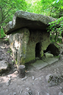
Dolman in Caucasus. Online photograph, public domain.


Dolman in Caucasus. Online photograph, public domain.

Burial structures known as dolmen occur through much of Eurasia, the Mediterranean, and in the Middle East as well. At their simplest they consist of three or four large rocks with a bigger cap rock on top to create a chamber, but they can be considerably more finished.


Dolman in Caucasus. Online photograph, public domain.

“In the North-West Caucasus, from Abkhazia the Taman Peninsula, are thousands of ancient dolmens which the locals call ‘ispun’, meaning the ‘houses of dwarves’. The megalithic structures were built during the early Bronze Age, from the middle of the 4th millennium BC to the end of the 2nd millennium BC. Dolmen construction consisted of a chamber built from several precisely dressed connected stone blocks, or were ca(r)ved in a rock mass. A large roof slab covered the chamber, whilst an access portal was formed by projecting blocks from the side walls and the overhanging roof slab. Most dolmens are punctuated with either a square, semi-circular, or oval access porthole in the centre of the façade, and can be specified into four basic types; slab, built-up, semi-monolithic and monolithic, with a typical floor plan that is square, trapezoidal, rectangular, and round.” (HeritageDaily 2021)


Dolman in Caucasus. Online photograph, public domain.

A very strange 2013 paper by Sharikov et. al. on the creation of these dolmen (see below) purports to prove that they were constructed without physical stone carving technology by casting fluids in molds that then hardened into the stone. Introduced by J. Davidovitz of his Geopolymer Institute, his application of fluidics was originally intended to prove that the blocks of stone in the pyramids of Giza in Egypt were cast, not carved from a quarry. This would be the Bronze Age equivalent of the site-cast concrete buildings of modern business parks where a wall, floor, or other component is cast horizontally on the ground out of reinforced concrete and then hoisted into place with preset, and carefully premeasured, steel components meeting upon erection to allow welding, riveting, or bolting them together to hold everything in place.


Dolman in Caucasus. Online photograph, public domain.


Dolman with carved (petroglyphic) elements on the front. Online photograph, public domain.

“There are raised patterns (petroglyphs) on the face slabs of some dolmens. To obtain such a relief, the builders would have to grind off the layer from the whole surface of the face slab. However the bas-relief is made very accurately. The stone surface is smooth and has no traces of stone working. The work on the creation of the bas-reliefs is very labor intensive and involves the use of very sophisticated stone working technology and special equipment.” (Sharikov et. al. 2013: 41) I do not understand why, if the slabs used in these constructions were cast from special fluids, why the patterns would not have just been cast in place instead of having to subsequently carve them. In other words, if you are making a mold to cast the whole wall in one piece why not modify the surface of the mold to create the pattern you want?


Carbonized tree limb found embedded in sandstone. Sharikov et al., 2013, Fig. 12, p. 43.

The team found “proof” of the fluid origin of the rock in the appearance of a  carbonized tree limb imbedded in the rock at one dolman. As this tree limb was not fully fossilized they could try to date the sample with radiocarbon. “The radiocarbon dating has been used to determine the age of carbon contained in the tree limb, which was found in the rock of the dolmen built near Pshada. This is the first attempt known to us to evaluate the time of fluidolites formation in the Caucasus. The measurements were carried out in 2010 using an accelerating mass-spectrometer (AMS) produced by the company NEC, in the Accelerator Mass Spectrometry Laboratory of the National Science Foundation of the USA, the University of Arizona (Tucson, USA). – According to the results got, the specimen of the charred wood in the rock dated back to 42,100 ± 1,500 years ago and the specimen of the tree limb in the rock dated back to 24,240 ± 190 years ago. It means that the sandstone of Pshada’s rock mass, which was used for the construction of a number of dolmens in the neighborhood, formed in the era corresponding to the upper Paleolithic age. The data are critical for further research, since they demonstrate that the rock used for the dolmens is of quite a ‘young’ geologic age – it can in no way belong to Mesozoic!” (Sharikov et. al. 2013: 43)


Dolman in Caucasus. Online photograph, public domain.

Sharikov et al go to great lengths to scientifically prove their theories that these dolmen were cast out of some fluid. They show microphotographs of polished samples of the material, and diagrams of how the earth forms were constructed and the panels were cast. What they do not do is present any evidence of an actual material analysis telling us what ingredients went into this wondrous fluid that they used to cast stone panels 42,000 to 20,000 years ago. This example of pseudoscience and its bogus conclusions do not have a place in serious discussion.


NOTE 1: An inquiry to the University of Arizona AMS Laboratory failed to clarify the claimed ages. They have been unable to find the reports cited by Sharikov et al.

NOTE 2: Some images in this posting were retrieved from the internet with a search for public domain photographs. If any of these images are not intended to be public domain, I apologize, and will happily provide the picture credits if the owner will contact me with them. For further information on these reports you should read the original reports at the sites listed below.

PRIMARY REFERENCES:

Heritage Daily, 2021, The Mysterious Dolmens of the North-West Caucuses, September 2021, https://www.heritagedaily.com

Sharikov, Ur. N., K. E. Yakobson, O. N. Komissar, Ya. V. Kusmin, and E. G. T. Jull, 2013, Investigations, Reconstruction and Geological Aspects of Dolmen Construction Technology in the North-West Caucasus, Archaeology 2013m Vol. 2, No. 2, pp. 38-46. 

SECONDARY REFERENCE:

Davidovits, Joseph, 2009-2017 (2 editions), Why the Pharaohs Built the Pyramids With Fake Stones, Geopolymer Institute, Saint-Quentin, France, ISBN: 9782951482043

Saturday, October 16, 2021

MIDDLE PLEISTOCENE HOMININ HAND AND FOOT IMPRESSIONS IN TIBET:


Handprint and footprint panel from Quesang, Tibet. Internet photo.

One subject of continual interest is the age of any example of art, particularly the earliest (oldest) example of art. Previously, pieces of ocher from Blombos Cave in South Africa had been claimed as the oldest example of petroglyphs in the world. One fragment, which has been dated to ca. 100,000 years BCE, bears a pattern of intentional scratch marks on the surface. On 25 August 2018, I wrote of this “All students of this question seem to share the assumption that the ocher was ground to make a pigment powder that can be mixed into paint for other use. What the current debate seems to be about is whether the designs on the ocher have any symbolic significance or whether they were perhaps only doodles.” (Faris 2018) While they look to me to have been created by scraping to get powdered ocher, they have been accepted as human made marks, thus possibly the oldest petroglyph.


There are always going to be questions about whether certain old traces of hominin activity should be classified as art. This is particularly relevant when it comes to recently described human hand and foot prints discovered in Tibet. By the same logic applied to the Blombos cave ocher, if the Tibetan hand and foot prints had been placed intentionally, ipso facto, they must be accepted as petroglyphs. just as the mud glyphs of Tennessee caves, or as painted handprints are accepted as pictographs.


Back in 2016 and 2017 I wrote a couple of columns on handprints and pictographs in Tibet as being the highest (altitude above sea level) rock art known. The handprints were reported from a location given as Chusang, which I assume is a different spelling for the same place as this report, Quesang. They were actual handprints in travertine limestone and were dated to approximately 7,400 years BP. Now new dating of handprints at Quesang have given us much older dates. (Faris 2017)


Closeup of handprints. Internet photo.

“At Quesang on the Tibetan Plateau we report a series of hand and foot impressions that appear to have been intentionally placed on the surface of a unit of soft travertine. The travertine was deposited by water from a hot spring which is now inactive and as the travertine lithified it preserved the traces. On the basis of the sizes of the hand and foot traces we suggest that two track-makers were involved and were likely children. We interpret this event as a deliberate artistic act that created a work of parietal art. The travertine unit on which the traces were imprinted dates to between ~169 and 226 ka BP. This would make the site the earliest currently known example of parietal art in the world and would also provide the earliest evidence discovered to date for hominins on the High Tibetan Plateau (above 4000 m a.s.l.).” (Zhang et al 2021)


New demonstation panel. "Active seep/stream below current hot spring with soft travertine in which the first author (Zhang) has placed three handprints in 2019." (Zhang 2021)

This particular area on the Tibetan plateau is supplied with a number of hot springs, both active and fossilized. This particular location is one of the fossilized hot springs.

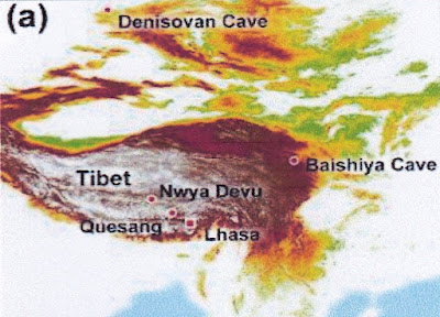
Regional context for Quesang prints showing other hominin locales.

“We argue that these traces were imprinted into soft travertine (pre-lithification) and were not carved after the travertine had lithified. On the basis of Uranium series dating the travertine unit in which the tracks are impressed dates from between ~169 and 226 ka BP. Based on the size of the tracks the trackmakers were likely two children and the traces were not imprinted during normal locomotion or by the use of hands to stabilize motion as reported at the Rocomonfina track site in Italy. Consequently, we argue that the deliberate track-making was likely and early act of parietal art.” (Zhang et al:2021)


Location of panel. "The site consists of a rocky promontory and the art-panel was exposed on the surface of one of these blocks by the natural removal of an overlying block." (Zhang et al, 2021)

Five hand prints and five footprints were recorded on the travertine unit under study. The team compared measurements of the prints to the growth curves of modern humans. “A growth curve suggests that the track-maker was of equivalent size to a Homo sapiens child with a mean age of 7.75 ± 0.12 (years). The length to width ratio of the hands falls within the modern range, although the fingers are more elongated. The average hand length is 161.07 ± 2.72 mm, which equates to a child with a mean age of 12.17 ± 0.18 a, using a modern Homo sapiens growth curve.” (Zhang et al:2021)

While you may or may not be able to think of them as art per se, they do seem to have been intentionally made, and that intentionality to modify a surface, to leave a physical trace, is at the root of all artistic creation. These prints seem to be the earliest currently known so we must consider them to be the oldest known examples of art.

NOTE: Some images in this posting were retrieved from the internet with a search for public domain photographs. If any of these images are not intended to be public domain, I apologize, and will happily provide the picture credits if the owner will contact me with them. For further information on these reports you should read the original reports at the sites listed below.

REFERENCES:

Faris, Peter, 2018, Oldest Petroglyphs So Far?, 25 August 2018, https://rockartblog.blogspot.com/search/label/Blombos%20 cave

Faris, Peter, 2017, High Altitude Rock Art – Tibet Yet Again, 30 September 2017, https://www.blogspot.com

Zhang, David D. et al, 2021, Earliest Parietal Art: Hominin Hand and Foot Traces From the Middle Pleistocene of Tibet, Science Bulletin (2021), DOI: 10.1016/j.scrib.2021.09.001

Saturday, October 9, 2021

SULAWESI'S BADA VALLEY MEGALITHS:


Lore Linda megaliths, Bada Valley, Sulawesi, Indonesia. Online photograph, public domain.


Lore Linda megaliths, Bada Valley, Sulawesi, Indonesia. Online photograph, public domain.

Earlier this year I posted two columns on the rock art of the island of Sulawesi (Faris 2021), one of the islands of Indonesia. One pictograph in a cave on Sulawesi is currently the oldest dated painted zoomorph known, dated to 45,500 BCE. Less widely advertised is a large collection of megalithic stone carvings in Lore Lindu National Park, a 2,180 km2 reserve in the province of Central Sulawesi. “There are over 400 granite megaliths in the area, of which about 30 represent human forms. They vary in size from a few centimeters to 4.5 meters. The original purpose of the megaliths is unknown. Other megaliths are in form of large pots (Kalamba) and stone plates (Tutu’na). Various archaeological studies have dated the carvings from between 3000 BC to 1300 AD.” (Indonesia-tourism.com)


Lore Linda megaliths, Bada Valley, Sulawesi, Indonesia. Online photograph, public domain.

Sulawesi, also known as Celebes, is one of the four Greater Sunda islands and was first inhabited during prehistory when the island almost certainly formed part of the land bridge used for the settlement of Australia and New Guinea by at least 40,000 BC. A majority of the present-day inhabitants descend from the Buginese or Bugis people, which are an ethnic group that migrated around 2000 BC to the area around Lake Tempe, and Lake Sidenreng, in the Walannae Depression in the southwest peninsula of Sulawesi.” (Heritage Daily 2021)


Lore Linda megaliths, Bada Valley, Sulawesi, Indonesia. Online photograph, public domain.
 
Varying styles in the presentation of the anthropomorphs and in details of their carving attest to more than one episode of carving.

“According to an inventory conducted by megalith enthusiasts of the Sagarmatha Faculty of Agriculture in 1994, there are over 300 (over 400 are now known) megalithic sites around the Lore Lindu National Park. Objects exist in the form of statues, large pots or vats, and stone mortars. Unfortunately, many of these ancient relics have been smuggled out of the area, sold and traded.” (Rosario 2020)

As is so common to we humans many of the carvings have been given names by the people.


Palindo megalith, Bada Valley, Sulawesi, Indonesia. Online photograph, public domain.


Palindo megalith in 1930s with Dutch tourists, Bada Valley, Sulawesi, Indonesia. Online photograph, public domain.

Palindo (The Entertainer) – “This (is) the largest statue in the area standing 440 cm from the ground. It is suggested that the Palindo is related to death, because his round face and large eyes face west. According to Toraja culture, a region in south Sulawesi, west is the direction of death. This theory holds some credibility based on the fact that the Toraja and Bada people share linguistic and cultural similarities. For example, both the Bada and Taraja sacrifice a buffalo for the deceased during funeral ceremonies. Another local legend talls of an ancient King of Luwu, who in order to prove his dominance, once ordered 1,800 of his subjects to move the statue from its location in the village of Sepe to Palopo, a long way south. The efforts failed, but as an insult to the abusive king, the people turned the once south-facing statue to the west. When the king’s followers tried to turn it back, it fell to its side, where it rests till today.” (Rosario 2020)


Maturu megalith, Bada Valley, Sulawesi, Indonesia. Online photograph, public domain.

Maturu (Sleeper) – “Measuring 3.8 meters, Maturu looks very much like a horizontal Palindo, but with very faded features. It was referred to by explorers from the early 1900s as ‘the statue that lies on its back.’” (Rosario 2020)


Kalamba megalith, Bada Valley, Sulawesi, Indonesia. Online photograph, public domain.

Kalamba (Large pots) – “Just up the path from Maturu, are vast stone cisterns, which are dotted across the valley. The Kalamba may have been used as baths or burial chambers for nobles and those of high status.” (Rosario 2020)


Oba megalith, Bada Valley, Sulawesi, Indonesia. Online photograph, public domain.

Oba (Monkey) – “This small fellow sits in the midst of a paddy field. It is a small statue, just barely over 40 cm from the ground. As its name suggests, this figure has amusingly monkey-like features.” (Rosario 2020)

All in all Sulawesi presents us with a number of new chinks in the armor of the old Euro-centric colonial assumptions on the development and advancement of human culture and force a serious and comprehensive re-appraisal of the role of Southeast Asia.

NOTE: Some images in this posting were retrieved from the internet with a search for public domain photographs. If any of these images are not intended to be public domain, I apologize, and will happily provide the picture credits if the owner will contact me with them. For further information on these reports you should read the original reports at the sites listed below.

REFERENCES:       

Central Sulawesi, indonesia-tourism.com, accessed in September 2021.

Faris, Peter, 2021, The Effects of Climate Change on the Pleistocene Rock Art of Sulawesi, 5 June 2021, https://rockartblog.blogspot.com

Faris, Peter, 2021, A New Candidate for the Oldest Pictograph – the Sulawesi Pig, 13, February 2021, https://rockartblog.blogspot.com

Heritage Daily, 2021, The Lore Lindu Megaliths, https://www.heritagedaily.com.

Rosario, Flame, 2020, Lore Lindu & the Mystifying Megaliths of Bada Valley, https://www.cryptoanthropologist.com

Saturday, October 2, 2021

TURTLES IN ROCK ART – THE HORNED TURTLE:


Horned Turtle petroglyph, Jeffers Petroglyph site, Minnesota. Photograph Peter Faris, 1993.

In Native American mythology the turtle plays many roles. Because of the protection afforded by the shell of the turtle he is often associated with warfare. Turtle was also seen as a source of warrior power since he carries his shield with him everywhere he goes.


Horned Turtle petroglyph, Jeffers Petroglyph site, Minnesota. Internet photograph, public domain.

At the Jeffers Petroglyph Site in Minnesota there is a very interesting image of a turtle with bison-like horns. In prehistoric vertebrate fossils a distinctly horned giant turtle was found in Australia. This creature was named Meiolaniidae and dated from the Pleistocene. Also, a South American horned turtle named Niolamia dates from the Cretaceous and Eocene; and Crossochelys was found in the South American Eocene. Unfortunately I could find no North American examples of horned turtles so the inspiration for this petroglyph is very unlikely to have been fossil remains.  

Horned turtle shield, provenance unknown. Photograph Housatonic Trading Company.


Horned turtle shield, p. 83, Afton, Jean, David Fridtjof, and Andrew E. Masich,1997, Cheyenne Dog Soldiers, Colorado Historical Society, Denver, Colorado.

At this time I have also been unable to locate references in Native American mythology to a horned turtle. I believe, however, that we can assume that if nothing else the addition of bison-like horns indicates a spiritual significance for the recipient. This assumption is backed up by images that I have located of three shields (one Arapaho and two possibly Cheyenne or Lakota) decorated with horned turtle subjects.


Arapaho horned turtle shield cover, 1850, Feder, American Indian Art, 1982, Harry N. Abrans, New York.

As we know that the decoration of a shield is generally spiritually significant, and is intended to lend the power of this spiritually significant subject to the warrior who possesses the shield, these suggest to me that the horned turtle does indeed have spiritual significance. Among Plains tribes the umbilical cord of a boy was often retained in a small turtle shaped amulet decoratively painted or beaded. Thomas Mails (1991) stated “Buffalo headdresses often had turtle designs painted on them or had small beaded turtle effigies appended to them.” (Mails 1991: 292)


Buffalo horned headdress with turtle amulet on top. Mails, Thomas E., 1991, Mystic Warriors of the Plains, copyright Thomas Mails, Barnes and Noble Books, New York.

This turtle effigy was indeed the umbilical cord amulet according to Mails. “When the child began to walk, the amulet was attached to his clothing to serve as a constant reminder of its purpose. Therefore, a child of five or six was known as a ‘carry your navel’. Sometimes the turtle was put away later on and other times it was kept by the mother. A boy often tied it to the left shoulder of his shirt, and then transferred ti to his buffalo-horned headdress if he became a renowned warrior.” (Mails 1991: 512) This suggests a connection between the turtle and buffalo horns for a “renowned warrior”. Given the examples of horned turtles on the Plains shields also providing a warfare context for the theme, I assume that the petroglyph of the horned turtle at the Jeffers Petroglyph Site has a martial implication, possibly the signature (in the form of a name glyph) of some renowned warrior.

 NOTE: Some images in this posting were retrieved from the internet with a search for public domain photographs. If any of these images are not intended to be public domain, I apologize, and will happily provide the picture credits if the owner will contact me with them. For further information on these reports you should read the original reports at the sites listed below.

REFERENCES:

Afton, Jean, David Fridtjof, and Andrew E. Masich,1997, Cheyenne Dog Soldiers, Colorado Historical Society, Denver, Colorado

Mails, Thomas E., 1991, Mystic Warriors of the Plains, copyright Thomas Mails, Barnes and Noble Books, New York.