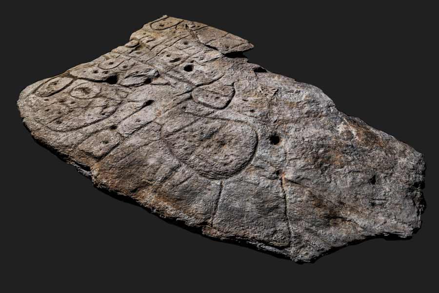
St. Belec slab, France. Photograph ancientorigins.net.
Well, here we go again. Another carved stone slab has been designated as a map, and not just any map. No, this map has been designated the oldest map in Europe.
Readers of RockArtBlog should know that I am very skeptical of claims of maps in rock art. I have gone so far as to say that I have not seen one yet in North America that I can agree is a map. It seems that when confronted by a mess of tangled lines on the rock face the fallback position for amateurs is always “that is a map of the surrounding area”. Indeed, the very first column I wrote for RockArtBlog was “Are There Maps In Native American Rock Art,” on April 18, 2009, debunking a claimed map on a petroglyph panel in southeastern Colorado.

In other locales, and other situations, I can accept the concept of a carved stone map, Q’enqo, in Peru, and a few other locales, have Incan carve stone representations of miniature landscapes that are thought to have been used in rituals. This might just be the case with the Saint-Belec slab.
The authors of the analysis believe it is a map meant to represent its surrounding region. “A recent re-examination of the Saint-Belec slab suggests that its sculptured surface and scattered motifs represent the surrounding landscape and a series of contemporary structures now known from archaeological evidence.” (Nicolas et al. 2021)

St. Belec slab, France. Photograph Bournemouth University, UK.
“When discovered, the slab formed the western side of one of the largest stone-cists in the region. It was orientated east-west and measured 3.86 m long, 2.1 m wide, and 1.86 m high.” (Nicolas et al. 2021) In other words it was used as part of the structure of a burial chamber under a mound or barrow. The work of constructing a stone burial chamber and raising a barrow over it suggests that the person buried inside was of some importance. The Bronze Age date assumed for this rock seems to be the result of its incorporation into a structure dating from that period, plus the fact that the authors state it does not bear any resemblance to earlier Neolithic carvings.
“A key point is that the engravers seem to have modified the original surface relief of the slab to create the desired 3D-form that compares to the topography of the surrounding landscape, the Odet River valley, overlooked by the Saint-Belec barrow. Furthermore, a series of lines appear to figure a more extended river network. To test this hypothesis, we have led several network and shape analyses that confirm a good correspondence between the carvings and the topography, with similar results to ethnographic solicited maps. Such correlations give the opportunity to georeference the Saint-Belec slab and get an idea of the possible scale of the space represented: an area c. 30 km long and 21 km wide. Furthermore, the carved motifs might have depicted early Bronze Age settlements, barrows, field systems, and tracks.” (Nicolas et al. 2021)

St. Belec slab, France. Photograph Bournemouth University, UK.
“While there are relatively few blank areas on the decorated surface, there is very little overlap of the motifs, except at their ends. Therefore, it appears that the successive phases in creating the panel did not significantly change the overall composition but were rather added in a planned way.” (Nicolas et al. 2021) In other words, there seems to have been a plan for the composition which was worked on until completed and then the surface was essentially left alone.
”One outstanding question about the Saint-Belec slab is why it was made? One possibility is that such a territorial depiction was a material and symbolic act enforcing. Set alongside the contemporary development of field systems in Brittany making the slab perhaps suggests the appearance of a new form of land tenure., while the distribution of elite graves is closely linked to soil fertility. Against this background, we can hypothesize that the Saint-Belec slab was used as a cadastral plan for managing the territory and controlling land.” (Nicolas et al. 2021) My interpretation of this statement is that the authors believe that this slab, representing a map of the surrounding area that the elite possessor had influence over, would have been used in the same fashion as a stereotyped military commander in a movie standing over his map table and making plans for actions.
I would like to suggest another possibility; where the authors state that “the Saint-Belec slab was used as a cadastral plan for managing the territory and controlling land,” I would like to suggest that it may have had a ritual function such as the above mentioned Q’enqo in Peru, where rites performed over the surface of this representation of the territory may have magically and/or spiritually effected the territory itself, perhaps for annual fertility rites, or magical security and protection.
In any case, if it was indeed used in such a fashion by an elite owner, it must then have been built into the wall of that elite’s tomb upon death and burial. So, in this case, I find myself agreeing that this may indeed be a map in rock art, but in this specialized way, not as an image per se of the land surface itself, but as a spiritual go-between representing the large area of land depicted.
NOTE: Some images in this posting were retrieved from the internet with a search for public domain photographs. If any of these images are not intended to be public domain, I apologize, and will happily provide the picture credits if the owner will contact me with them. For further information on these reports you should read the original reports at the sites listed below.
REFERENCES:
Faris, Peter, 2009, Are There Maps In Native American Rock Art?, April 18, 2009, https://rockartblog.blogspot.com
Nicolas, C., Y. Pailler, P. Stephan, J. Pierson, L. Aubry, B. Le Gall, V. Lacombe, and J. Rolet, 2021, La Carte et le Territoire: La Dalle Gravee du Bronze Ancien de Saint-Belec (Leuhan, Finistere), April 2021, Bulletin de la Societe Prehistorique Francaise, tome 118, 1, p. 99-146.


No comments:
Post a Comment