Flag Point track site, Grand Staircase-Escalante National Monument, Utah. Internet photo public domain.
Painted track at Flag Point track site, Grand Staircase-Escalante National Monument, Utah. Internet photo public domain.
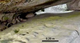
Chirotherium track, Joseph City, New Mexico. Photograph from Mayor and Sergeant, 2001.
Petroglyph of chirotherium track, Joseph City, New Mexico. Photograph from Mayor and Sergeant, 2001.
I think
that my two favorite things in the world may be rock art and dinosaur tracks.
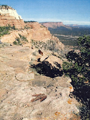
And I would imagine that we all know about the red pictograph of the nearby
dinosaur track at Flag Point in Grand Staircase – Escalante National Monument
in Utah. RockArtBlog published a column about that marvel on 21 November 2015
in a column titled “A Painted Dinosaur Track in Utah.” Also, on 13 June 2014 I
wrote a column titled “A Dinosaur Track Petroglyph” on a report by Adrienne
Mayor and William Sarjeant of a petroglyph they believe was inspired by a
nearby dinosaur track. Now, I have seen a report about a site in Lesotho, a
sovereign enclave in South Africa, painted by a San bushman a artist that not
only records a dinosaur track, but apparently includes a couple of images of
the creature that the artist imagined to have made the track (Helm et al. 2012)
Mokhali Cave, Lesotho. Photograph Helm et al. Fig. 3.
The
pictographs at this site were first recorded by one Paul Ellenberger, the son
and grandsonof two generations of missionaries and ministers in Lesotho. “Swiss-born D.
Frédéric Ellenberger (1835-1910) came to Lesotho in 1861. He spent the next 44
years in this work, first in Morija and then in Masitise, where he created
temporary accommodation by building a stone wall in front of a massive rock
overhang. He lived with his family in this Cave House for 13 years.” (Helm
et al. 2012) One of Ellenberger’s children, Victor, later visited the site with
his own son, Paul, who recorded the pictographs. “Victor Ellenberger (1879-1972)
was born in this Cave House while a war raged outside. He excelled as a student
and went to France for his secondary education, then worked as a minister from
1917 to 1934 in Lesotho (mainly at Leribe) and then in Paris. He became an
expert on Lesotho’s flowering plants, changing environmental conditions and the
tragic end of the San, and published books on these topics. With the help of
his son Paul he copied over 400 San paintings.” (Helm et al. 2012)

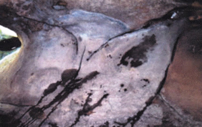
San painted track image, Photograph Helm et al. Fig. 4.
Victor and
Paul visited the site accompanied by Frederic Christol (1850-1933), a Lutheran
minister and artist. “Armed with this knowledge of the
Ellenbergers, we can imagine a 1930 visit to a rock overhang 10 km north-east
of Leribe (Hlotse) known as Mokhali Cave. Victor was the minister in Leribe and
likely the orchestrator. Present were Victor’s father-in-law, the artist
Christol, and 12-year-old Paul, who was given the task of tracing the paintings.
While his grandfather sketched the cave, Paul traced the wonderful images,
which were unlike anything he or his father had seen before. Beside a painting
in red ochre of a three-toed dinosaur footprint, there were three graceful
figures of the imagined track-maker.” (Helm et al. 2012) Since the
footprint is three-toed made by an ornithopod, the San artist had recognized
its resemblance to a bird track and created the three imaginary figures which
are very birdlike.
San painted track image enhanced, Photograph Helm et al. Fig. 5.
As is so often the case, the original
drawings had been filed away and essentially forgotten. “The tracings had languished in obscurity in Lesotho and then in
Montpellier (Montpellier University in France). But in 1989 David Mossman, a Canadian paleontologist on sabbatical in
France, met Ellenberger and learned about them. In 2004 he lectured in South
Africa and visited Mokhali Cave with his son Alex. They located it after an
exhaustive two-day search, finally identifying it with the use of a copy of
Christol’s sketch. Unfortunately the paintings had faded badly – the footprint
(resembling that of an ornithopod) was just discernible, but the track-maker
images were no longer visible. Ellenberger and the Mossmans then collaborated
with renowned ichnologist Martin Lockley in submitting the article to Ichnos.” (Helm et al. 2012)
The claim by Ellenberger et al. (2005)
that the track-maker images predate European attempts was based on the estimated
latest possible occupation of Mokhali Cave by the San (1810-20), before it was
occupied by the son of the Basotho king and before the San were killed or
driven from the region. Implicit in such an estimate is the possibility that
they may have been made even earlier. This report assumes that the San were the artists. (Helm et al. 2012)
Drawing of San painted track image and imagined track makers, image courtesy David Mossman, from Helm et al. Fig. 2.
“Employing
technologies developed in astronomy, forensics and medicine, and applying them
specifically to rock art, Kevin Crause has developed the CPED Toolset –
Capture, Processing, Enhancement, Display. After obtaining high-resolution
images, data is colour-balanced and processed to remove lens distortion.
Designed enhancement algorithms resolve imagery details that cannot be resolved
under normal light conditions as perceived by the human visual system. By using
this technology, images often result of rock art that are no longer visible to
the naked eye. We wondered what the CPED Toolset could offer regarding the
faded footprint and track-maker images. Kevin and Charles Helm revisited
Mokhali Cave to test this in 2011. The cave, which we found without difficulty
thanks to excellent directions from the Mossmans, is 75 m wide, 10 m high and 5
m deep. It provides a magnificent north-facing view over the Caledon Valley and
its level floor is wide and deep enough to encourage habitation, as in
Christol’s sketch, which depicts three Basotho huts. However, it is exposed to
the elements. Northerly winds, winter snow and freeze-thaw events damage the
paintings on its walls, which are prone to flaking off. The chances of rock art
surviving seemed remote. However, the footprint, 2 m from the eastern end of
the cave, was recognizable. Midway along the floor were the remains of a
circular hut. In addition to analysing the footprint and surrounding area, all
promising surfaces in the cave were photographed. This yielded a few images of
so-called Late White paintings by Bantu-speaking agriculturalists (Lewis-Williams
2006), likely representing Basotho rock art, but also suggesting the
possibility of Basotho artists creating the dinosaur images. Rock art shelters 200mfurther
east yielded numerous San paintings. In the valley of the Subeng Stream below,
3 km from Mokhali Cave, we visited a dinosaur tracksite that was recorded by
Ellenberger in the 1950s. From here Mokhali Cave was visible."
(Helm et al. 2012)
“Computer
programs have enhanced the image quality at this site, confirming the accuracy
of Paul Ellenberger’s 1930 tracing and the relation of the footprint to the
track-maker images. However, for details on the track-maker images, the efforts
over 80 years ago of a remarkable pre-teenager remain the sole source. Future
work is required to resolve the origin of this rock art and, if possible, its
age.” (Helm et al. 2012) This may be a reference to their CPED toolset
or possibly they finished it up with D-Stretch, in any case they now have
provided a great image of the painted footprint that was previously hard to see.
NOTE: Some images in this
posting were retrieved from the internet with a search for public domain
photographs. If any of these images are not intended to be public domain, I
apologize, and will happily provide the picture credits if the owner will
contact me with them. For further information on these reports you should read
the original reports at the sites listed below.
REFERENCES:
Faris, Peter, 2015, A Painted Dinosaur Track in Utah, 21 November 2015,
rockartblog.blogspot.com.
Faris, Peter, 2014, A Dinosaur Track Petroglyph, 13 June 2014, rockartblog.blogspotcom.
Helm, Charles, Kevin Crause and
Richard McCrea,
2012, Mokhali Cave Revisited, Dinosaur
Rock Art in Lesotho, April 2012, The Digging Stick, Vol. 29, No. 1. Accessed
from Researchgate.net.
Mayor, Adrienne and William A. S. Serjeant, 2001, The Folklore of Footprints in Stone: From Classical Antiquity to the
Present, Ichnos, Vol. 8, No. 2, 143-163.
SECONDARY REFERENCES:
Ellenberger,
P, Mossman, DJ, Mossman, AD, & Lockley, MG. 2005. Bushmen cave
paintings of ornithopod dinosaurs: paleolithic trackers interpret Early Jurassic
footprints. Ichnos, Vol. 12 No. 3, 223-226.