Saturday, July 27, 2024

STONE BLINDS AND DRIVELINES REVISITED – BALTIC SEA ‘BLINKERWALL':

Rollins Pass Driveline, Grand County, CO.,1 mi. of fence, 174 pit blinds & 184 cairns, ca. 6,000 - 3,000 BC, Photograph Peter Faris,  25 July 1987.

One interesting facet of the study of geoglyphs is the fact that many of them are connected to hunting in some way. Some are just simple hunting blinds where the hunter can be concealed while waiting for prey. Some are complex traps for prey, and some are meant to influence the movement of the animals in such a way that benefits a waiting hunter. This last seems to be the case for the recently discovered wall under the Baltic Sea.

Back on 14 February 2015 I published” Stone Blinds and Drivelines – Rollins Pass, CO.” on RockArtBlog, about visiting the vast stone drivelines and hunting blinds on Rollins Pass in the Colorado Rockies with Doctor James Benedict, the noted high mountains archaeologist. Most of the drive lines are now only one or two stones high, any animal could easily step over them, but apparently they are still doing the job today that they were constructed for long ago. Dr. Benedict stated that one day during one of his recording trips to the site he watched a deer or elk wandering up the slope stop and divert to the side when it came to one of the drive lines, even in their modern broken down and aggraded condition.” (Faris 2015) Apparently their effectiveness depends on the artificial appearance of a straight line in the natural environment. Benedict had estimated that more than a mile of stone walls remain on that location.

3-D model of the west end of the Blinkerwall. Image by Phillipp Hoy, Rostock University, Rostock, Germany.

Now, in 2021, such a construction has been located under the Baltic Sea dating back to before the rise in sea levels at the end of the glaciations period, estimated to be roughly 11,000 years ago there.

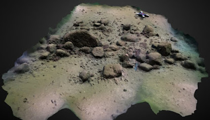
“In 2021, Jacob Geersen, a geophysicist with the Leibniz Institute for Baltic Sea Research in the German port town of Warnemünde, took his students on a training exercise along the Baltic coast. They used a multibeam sonar system to map the seafloor about 6.2 miles (10 kilometers) offshore. Analyzing the resulting images back in the lab, Geersen noticed a strange structure that did not seem like it would have occurred naturally. Further investigation led to the conclusion that this was a manmade megastructure built some 11,000 years ago to channel reindeer herds as a hunting strategy. Dubbed the "Blinkerwall," it's quite possibly the oldest such megastructure yet discovered, according to a new paper published in the Proceedings of the National Academy of Sciences—although precisely dating these kinds of archaeological structures is notoriously challenging.” (Ouellette 2024) The assumption is that it functioned with the local reindeer exactly like Dr. Benedict (above) related for the Rollins Pass drive lines. The reindeer would divert and follow the fence to a location where the hunters waited in ambush.

The Blinkerwall, the oldest structure in the Baltic Sea. Illustration by Michal Grabowski.

“The discovery is made up of more than 1,300 stones and roughly 300 larger boulders, and it stretches for more than half a mile along the seafloor. Resting nearly 70 feet underwater in the Bay of Mecklenburg, the wall stands, on average, about 1.5 feet tall. Natural events, such as glacial deposits or other land movements, cannot account for this structure’s existence, researchers report in a study published Monday in Proceedings of the National Academy of Sciences. Instead, they argue, the roughly 11,000-year-old wall was a tool built by hunters to guide and trap reindeer, which tend to travel along straight elements of the landscape, such as cliff sides or streams. ‘Hunters tapped into the natural behavior of the animals and created their own linear feature,’ Ashley Lemke, an underwater archaeologist at the University of Wisconsin-Milwaukee who was not involved with the research, tells Science’s Andrew Curry. ‘It’s not an obstruction, it’s a trail. They follow it to where the hunters are waiting.” (Thorsberg 2024) This preceding description is a very good explanation of how and why such drivelines work.

Scan of the west end of the Blinkerwall.

"'At this time, the entire population across northern Europe was likely below 5,000 people. One of their main food sources were herds of reindeer, which migrated seasonally through the sparsely vegetated post-glacial landscape. The wall was probably used to guide the reindeer into a bottlenick between the adjacent lakeshore and the wall, or even into the lake, where the Stone Age hunters could kill them more easily with their weapons,' explains Marcel Bradtmoller from the University of Rostock. The last reindeer herds vanished from these regions approximately 11,000 years ago due to climate warming and forest expansion. Consequently, the stone wall was probably not constructed after this period. If this is accurate, it would classify the wall as the oldest human-made structure ever found in the Baltic Sea." (Waters 2024)

The animals are diverted along the construction by its very existence on the site, ending up exactly where the waiting hunters want them to be for maximum advantage in harvesting game. Since reindeer migrate in large groups the harvest could have been quite large, illustrating the effectiveness of such a tactic.


Detailed structure of the Bay of Mecklenburg including the location of the Blinkerwall. Bathymetric data from The Federal Maritime and Hydrographic Agency Bundesamt für Seeschifffahrt und Hydrographie (BSH).

The only other possible explanation for this wall (other than it being a drive line) was what the authors (Geersen et al.) call ‘stone fishing.’ “In the absence of basal complexes and basement rocks in Northern Germany, glacially derived stones were used for construction purposes in this area toward the end of the last millennium. The demand for stones resulted in the birth of stone fishing as a profession. Stone fishing represents an anthropogenic effort to move and conquer boulders from the marine environment using stone pincers and ropes. -  After 1906, stone fishing was prohibited, and the stones were left in place being identified as important habitat and also useful for coastal protection. Because stone fishing (had) concentrated on the near-coastal waters and was not done in the central basins, we consider an anthropogenic movement of the stones for the purpose of stone fishing an unlikely candidate to explain the construction of the Blinkerwall. Furthermore, it seems unlikely that within the 18th and 19th century, stone fishers would have been able to place the stones next to each other over a distance of about 1 km given the water depth of about 21 m. Let alone the fact that their intention was to remove the stones rather than place them elsewhere on the seafloor.” (Geersen et al. 2024)

So, logically, the fact that the wall is now under 21 meters of water and that it was constructed by humans, the most likely explanation for it is that it was constructed when that area was still dry land, which dates it to the end of the last Ice Age. A very impressive accomplishment for people back then, and an impressive job of deduction for the authors (Geersen et al. 2024) of the report.

NOTE 1: Some images in this posting were retrieved from the internet with a search for public domain photographs. If any of these images are not intended to be public domain, I apologize, and will happily provide the picture credits if the owner will contact me with them.

NOTE 2: I have not included secondary citations in the References (below). For further information on these reports and all sources you should read the original reports at the sites listed below.


REFERENCES:

Faris, Peter, 2015, Stone Blinds and Drivelines – Rollins Pass, CO., 14 February 2015, https://rockartblog.blogspot.com.

Geersen, Jacob, Marcel Bradtmoller, Jens Schneider von Deimling and Harald Lubke, 2024, A submerged Stone Age hunting architecture from the Western Baltic Sea, 12February 2024, PNAS, Vol. 121, No. 8, https://www.pnas.org. DOI.org/10.1073/pnas.231008121. Accessed online 20 May 2024.

Ouellette, Jennifer, 2024, Scientists found a Stone Age megastructure submerged in the Baltic Sea, 14 February 2024. Proceedings of the National Academy of Sciences 2024, DOI: 10.1073/pnas.2312008121, https://arstechnica.com. Accessed online 17 February 2024.

Thorsberg, Christian, 2024, Stone Age Wall Discovered Beneath the Baltic Sea Helped Early Hunters Trap Reindeer, 13 February 2024, https://www.smithsonianmag.com. Accessed online 17 February 2024.

Waters, Conny, 2024, Underwater Drone Images Reveal Oldest Human-Made Structure In The Baltic Sea, 13 February 2024, https://ancientpages.com. Accessed online 14 February 2024.

Saturday, July 20, 2024

BOLSHOI ZAYATSKY GEOGLYPHS - ENIGMATIC ISLAND OF LABRYNTHS:


The black arrow points to the location of Bolshoi (Big) Zayatsky Island. Internet image, public domain. The arrow points to the location of the island.

New Agers and other Fringies impart great spiritual significance to mazes and labyrinths. Just following the path is supposedly going to make you feel more spiritual. Now I am admittedly a skeptic on many things considered spiritual and certainly no New Ager, but it is also the case that many cultures over the centuries have included related beliefs in their spiritual lives. Among other things, labyrinths and mazes are often used as puzzles where one starts at the outside and attempts to find the center, whether with a pencil on paper or on foot in one of the cornfield mazes currently popular in the fall. 

One of the Bolshoi Zayatsky labrynths. Online image, public domain.

“Labyrinths have been found in just about every major religious tradition in the world, have formed an integral part of many cultures, and have been found on every inhabited continent.  At about the same time as the appearance of the Greek labyrinth, an essentially identical pattern appeared in Native American culture, the Tohono O'odham labyrinth, which features I'itoi, the "Man in the Maze". A prehistoric petroglyph on a riverbank in Goa shows the same pattern and other examples have been found among cave art in northern India and on a dolmen shrine in the Nilgiri Mountains. In terms of ancient archaeological monuments, more than 300 examples of labyrinths can be found in various locations around the world.  Many questions remain around how the same pattern managed to appear at the same time in apparently disparate cultures.”(Holloway 2014)


Large stone labrynth. Internet image, public domain.

There is, however, one location where the largest concentration of labyrinths in the world can be found. “Such labyrinths have been discovered all over the world, but the greatest number of them is concentrated on the Solovetsky Islands (Arkhangelsk Region) – about 35, with 14 of them on Bolshoi Zayatsky Island. Besides these labyrinths, hundreds of mounds, piles of boulders and dolmens were also found, which proves that the archipelago in the White Sea was inhabited in ancient times. It’s known that in the 1st millennium BC, nomadic Saami tribes lived there, but they were not the first – the radiocarbon analysis of the objects showed traces of humans of the 6th-7th millennium BC. The labyrinths themselves date back to about 1st -2nd millennium BC, which means that they should have built before the Saami or Proto-Saami people. But some stone patterns could have been made later too.” (Goldman 2022) Dating of these remains speculative for the most part, wild guesses ranging from 30,000 BCE to historical can be found.

Stone labrynth. Bolshoi Zayatsky Island, Russia. Image from Pinterest.

“Also, such labyrinths were found on the islands of the Kuzova Archipelago in Karelia and not far from the town of Kandalaksha in Murmansk Region, as well as in some areas of Siberia. All of them are either on islands or in river estuaries, i.e. near water.” (Goldman 2022) It would seem that there is something in the culture that led to this proliferation of labyrinths.

Stone labrynth. Bolshoi Zayatsky Island, Russia. Internet image, public domain. The largest labrynth measures 25.4 meters in diameter.

 "All in all, there are 35 labyrinths (known as vavilons - 'Babylons' - in the local dialect) in the Solovetsky Islands. All have been made of local boulders. Excavations in the stone heaps have yielded parts of bones. Measuring between 6 - 25.4 m (20 - 83 ft) in diameter, the labyrinths are mostly made of boulders (c. 30 - 40 cm (12-16 in) in diameter) set in a row. The rows are twisted in the form of a spiral; often there are two spirals set one into another, which has been likened to 'two serpents with their heads in the middle looking at each other." Intermittently along the spiral there are thicker or wider heaps of stones; the ends of the spirals are also wider." (Wikipedia) This complicates the matter even further, heaps of stones and widened ends are design features not shared by all of the labyrinths, so what does that mean?

Stone labrynth. Bolshoi Zayatsky Island, Russia. Internet image, public domain. 

“Apart from rituals, labyrinths, at least some of them, could also have a purely practical meaning. The Soviet archeologist Nina Gurina, having studied Karelian and Murmansk labyrinths, assumes that they were intended for fishing. The point is that the water level could have been higher centuries ago and such stone traps ‘locked’ the fish without distracting people from other things.” (Goldman 2022) While this might be a possible use it strikes me as unlikely. There are, in fact, much more effective shapes for fish traps that would have involved moving considerably less rock. And what about the ones that are on higher ground that would not have been submerged – and why so many? All questions that I have not found answers to, but an interesting subject for speculation. What do you think?

NOTE: Some images in this posting were retrieved from the internet with a search for public domain photographs. If any of these images are not intended to be public domain, I apologize, and will happily provide the picture credits if the owner will contact me with them. For further information on these reports you should read the original reports at the sites listed below.

REFERENCES:

Goldman, Eleonora, 2022, Mysterious stone labyrinths in the Russian North – what are they?, 15 April 2022, Russia Beyond (online), https://www.rbth.com. Accessed online 28 May 2024/

Holloway, April, 2014, The Ancient Stone Labyrinths of Bolshoi Zayatsky, 14 April 2014, https://www.ancient-origins.net/. Accessed online 28 May 2024.

Wikipedia, Stone labyrinths of Bolshoi Zayatsky Island, https://en.wikipedia.org/. Accessed online 27 May 2024.


Saturday, July 13, 2024

A 16,800 YEAR OLD PALEOLITHIC DWELLING FOUND IN LA GARMA CAVE:


The dwelling floor inside the Cave of La Garma. Photograph from the government of Cantabria.

Another Paleolithic dwelling has been discovered, this one in a decorated cave in Spain – La Garma.

Stenciled handprints, La Garma Cave, Spain. Photograph from arterupestrecantabrico.es.

La Garma Cave, Spain. Internet image, public domain.

“The La Garma cave complex is a parietal art–bearing paleoanthropological parietal cave system in Cantabria, Spain, located on the southern side of La Garma Hill, north of the village of Omoño, part of the municipality of Ribamontan al Monte. The cave complex contains more than 4,000 fossils and more than 500 graphical units, with 109 signs, 92 animal figures, and 40 hand stencils. The cave complex is noted for containing one of the best preserved floors from the Paleolithic. La Garma is listed as part of the Cave of Altamira and Paleolithic Cave Art of Northern Spain World Heritage Site.” (Wikipedia)

Another view of the dwelling floor, La Garma Cave, Spain. Internet image, public domain.

“A project led by Pablo Arias and Roberto Ontañon from the University of Cantabria has recently announced the discovery of a Paleolithic dwelling within the cave system, described as ‘one of the best preserved Paleolithic dwellings in the world.’ The dwelling is an oval space and is delimited by an alignment of stone blocks and stalagmites that supported a fixed structure of sticks and skins leaning against the cave wall. The total area of the space is around 5 square meters that centered on a camp fire. Archeologists also found vestiges of various daily activities associated with Magdalenian hunters and gatherers at the dwelling, including evidence of stone manufacturing, bone and antler instruments, and the working of fur.” (Milligan 2023) It is assumed that the dwelling was constructed of animal skins over a framework of sticks, somewhat like the North American Tipi.

Note the presence of the fire in the dwelling. The temperature of the inside of a cave (away from the entrance) is relatively consistent year round and stays close to the average surface temperature of the region it is located in (usually somewhere between 50˚F and 70˚F). Much below the 70˚F mark and they inhabitants would need to keep a fire going for warmth. This also implies that they must have carried fire wood inside the cave. We can possibly also infer that they used a torch to traverse the distance from the cave mouth to the dwelling, which was 130 meters.

Carved bone aurochs, La Garma Cave, Spain. Internet image, public domain.

Carved bone ibex, La Garma Cave, Spain. Internet image, public domain.

“Researchers believe there was a small bonfire in the center of the space, in which a multitude of daily tasks would have taken place. They believe a group of Magdalenian hunters and gatherers shared the space and they have documented 6,614 objects from the dwelling including deer, horse and bison bones as well as 600 pieces of flint, needles and shells of marine mollusks. Among the discoveries was a decorated bone and several pendants that researchers believe dwellers wore as jewelry.” (Stavrou 2023)

Carved bone animals from La Garma Cave, Spain. Photograph by Pedro Saura.

Of course we have no proof that the residents of this dwelling in La Garma are the people who created the cave art. We do, however, have indications that they were industrious in the 6,614 artifacts retrieved from the dwelling.

A number of these are carved bone animals of the same species as the wall paintings, lending a certain degree of credence to the case for the painting of these same animals on the cave wall by the inhabitants.

Cave painting, La Garma Cave, Spain. Photograph unilad.com.

“It has been described as a ‘time capsule’ by the local government as the original entrance to the cave was blocked by a landslide around 16,000 years ago, preserving the ancient remains inside.” (Stavrou 2023) This should be considered irrefutable proof of the ancient age of the dwelling, the bone carvings as well as the cave art. They have to have been done more than 16,000 years ago. How many more marvelous discoveries are waiting to be found if we only keep searching?

NOTE 1: Strangely, I have been totally unable to find a translation of the word Garma from Spanish to English.

NOTE 2: Some images in this posting were retrieved from the internet with a search for public domain photographs. If any of these images are not intended to be public domain, I apologize, and will happily provide the picture credits if the owner will contact me with them. For further information on these reports you should read the original reports at the sites listed below.

REFERENCES:

Milligan, Mark, 2023, 16,800-year-old Palaeolithic dwelling found in La Garma cave, 1 December 2023, https://www.heritagedaily.com. Accessed online 2 December 2023.

Stavrou, Athena, 2023, Archaeologists discover prehistoric ‘time capsule’ in mystery cave dwelling, 6 December 2023, https://www.independent.co.uk/news/, Accessed online 19 December 2023.

Wikipedia, La Garma Cave Complex, https://en.wikipedia.org/wiki/La_Garma_cave_complex. Accessed online 10 Januardy 2024.

Saturday, July 6, 2024

MUSIC AND DANCE IN ROCK ART - THE TORO MUERTO PETROGLYPHS:

Dancers from Toro Muerto, Peru. Image from Toro Muerto Archeological Research Project Archives.

A huge number of petroglyphs can be found at a site called Toro Muerto in Peru. Although Toro Muerto is one of the largest rock art sites in Peru it has not been extensively studied. Recently a team of archeologists has published studies of the rock art of Toro Muerto. Andrzej Rozwadowski, Liz Gonzales Ruiz and Janus Z. Woloszyn published a paper in 2019 covering the rock art of Toro Muerto in general, and then in 2024 Rozwadowski and Woloszyn followed that with an analysis of the themes on some of the boulders as dancers and representations of the music accompanying the dancers.

Toro Muerto petroglyph boulder. Photograph A. Rozwadowski.

Dancers with zig-zag lines. Toro Muerto petroglyph boulder.  Drawing Polish-Peruvian research team.

“Toro Muerto, meaning ‘dead bull’ in Spanish, is a significant rock art complex located in southern Peru, nestled within a desert gorge near the Majes River Valley. Encompassing and expansive area of approximately 10 square kilometers (3.86 sq mi), this site holds around 2,600 volcanic boulders, each adorned with ancient petroglyphs. These petroglyphs vary in size and complexity ranging from small stones featuring single motifs to massive boulders adorned with intricate arrays of multiple images.” (Pandey 2024)

Another Toro Muerto petroglyph boulder with dancers and zig-zag lines. Photograph A. Rozwadowski. Drawing Polish-Peruvian research team.

“Unique to the Toro Muerto petroglyphs are the drawings of the so-called "danzantes" or dancers. A danzante is a schematic drawing of a human figure, usually 20-30 cm high, often depicted in a dynamic pose with one arm raised and the other lowered, legs slightly apart (sometimes bent at the knees), and the head presented in profile or facing forward. While the geometric patterns, lines, and zigzags accompanying the danzantes were initially thought to represent snakes or lightning bolts, Polish scientists who analyzed these 2,000-year-old rock carvings have proposed a different theory.” (Waters 2024)  On 15 April 2012, I wrote a column on RockArtBlog about Dancing Figures in rock art (Faris 2012). At that time I had not yet seen any of these marvelous petroglyphs at Toro Muerto.

Another Toro Muerto petroglyph boulder with dancer and zig-zag lines. Photograph A. Rozwadowski.

“A new study published in the Cambridge Archaeological Journal proposes a novel interpretation: the abstract geometric shapes adorning the volcanic boulders might be representations of ancient songs potentially linked to shamanic rituals involving hallucinogenic plants.” (Radley 2024) I would think that this implies a strange twist on the neuropsychological model, stating that the petroglyphs represent visions seen accompanying music during hallucinations.

“It is worth noting that Antonio Núñez, Cuban ambassador to Peru and one of the most important early researchers of Toro Muerto, suggested that some of the geometric motifs he observed at this site (zigzags, straight lines, points) represent musical or dance signs(signos musicales o danzarios), or sound communication.” (Rozwadowski and Woloszyn 2024)

Rudolph Laban. Image from Wikipedia.

Laban Dance Notation System chart. Internet image, public domain.

So, the idea that the lines, zigzags, etc., represented music that the anthropomorphs are dancing to has been considered a possibility since these petroglyphs were first studied. When I first saw the pictures I was struck by their resemblance to Laban diagrams invented to record dance movements. This is officially known as “Laban Movement Analysis." “LMA is largely taken from Rudolph Laban’s ‘The Mastery of Movement,’ first published in 1950. A choreographer and dance theorist hailing from Austria-Hungary, Laban was a pioneer of modern dance as we know it today. - - He also created intricate taxonomies for understanding human movement, such as labonotation, a theory of dance notation and analysis.” (Woltmann 2022) Now, I am not suggesting that these petroglyphs that accompany the ‘dancers’ are actually something like a Laban diagram, but I find the resemblance to be striking, a fascinating coincidence.

NOTE: Some images in this posting were retrieved from the internet with a search for public domain photographs. If any of these images are not intended to be public domain, I apologize, and will happily provide the picture credits if the owner will contact me with them. For further information on these reports you should read the original reports at the sites listed below.


REFERENCES:

Faris, Peter, 2012, Dancing Figures, 15 April 2012, https://rockartblog.blogspot.com/search/label/Dancing%20figures.

Pandey, Sahir, 2024, Are Toro Muerto’s Petroglyphs in Peru Hallucinogenic Visions in Stone, 10 April 2024, https://www.ancient-origins.net. Accessed online 25 May 2024.

Radley, Dario, 2024, Geometric petroglyphs in Peru may represent ancient songs from shamanic rituals, 8 April 2024, https://archaeologymag.com. Accessed online 9 April 2024.

Rozwadowski, Andrzej, and Janus Z. Woloszyn, 2024, Dances with Zigzags in Toro Muerto, Peru: Geometric Petroglyphs as (Possible) Embodiments of Songs, pp. 1-21, published online by the Cambridge Archaeological Journal on behalf of the McDonald Institute for Archaeological Research, Cambridge, UK. Accessed online 13 May 2024.

Waters, Connie, 2024, Ancient Petroglyphs In Toro Muerto Are Not What We Thought – Archaeologists Say, 24 May 2024, https://ancientpages.com. Accessed online 24 May 2024.

Woloszyn, Janus Z., Liz Gonzales Ruiz, and Andrzej Rozwadowski, 2019, The Petroglyphs of Toro Muerto: new documentation and discoveries at the largest South American rock art complex, pp. 1-8, Antiquity, Vol. 93, No. 372. https://doi.org/10.15184/aqy.2019.200. Accessed online 14 May 2024.

Woltmann, Suzy, 2022, Laban Movement Analysis: An Introduction for Actors, 18 July 2022, https://backstage.com/magazine/article/laban-movement-analysis-guide-50428. Accessed online 26 June 2024.