Saturday, May 28, 2022

MISINTERPRETING LA PASIEGA:


Neandertal scalariform and associated pictographs, La Pasiega Cave, France. Illustration from www.donsmaps.com.

In a 2019 paper Mark-Olivieri Rondu provided a very detailed theory explanating the scalariform symbol group in the cave of La Pasiega in France. He based this interpretation on agricultural symbolism which is just impossible given the dating of the symbol. “In 2018 uranium-thorium dating revealed a scalariform (ladder-shaped)symbol to be older than 64,000 years and therefore made by Neanderthals.” (Wikipedia) (see RockArtBlog for 5 February 2022, “DATED NEANDERTAL CAVE ART PROVIDES A NEW CANDIDATE FOR OLDEST ROCK ART”).


Breuil's map of La Pasiega Cave, France. Illustration donsmaps.com.

In 1913 Abbe Henri Breuil published his study of La Pasiega, designating the vertical arrangement of three rectangles with partial zoomorphs indicated in the top and bottom rectangle “la Trampa,” the trap. “On the panel 78, gallery C, a composition called by Breuil et al. ‘la Trampa’ (The Trap) is composed of a rectangular shape made of red lines called a scalariform pattern which shelters two uncomplete (sp) representations of animals considered here to be a pregnant sow in the rectangle on top and below, the first half of a reindeer female. Both animals are separated by an empty space. On the upper left angle, close to the sow’s back, two groups of semi-circular dotted lines caps the scalariform shape.” (Rondu 2019)


Neandertal painting, La Pasiega Cave, France. Illustration donsmaps.com.

“Semi-circular dotted lines compose a single representation of a time continuum in accordance with the angle made by the sow and the induced position of the sun at the horizon. The first ‘unfinished’ group of semi-circular dotted line is made of 46 dots associated to the timing in hours of the sow rut (usually lasting between 48 and 72 hours) during the last phase of equinox of autumn. The equinox is represented by the angle made by the unfinished semi-circular group, the animal and the horizon. The second semi-circular dotted line is longer and almost perfectly semi-circular. It is composed of 103 dots coinciding with the sow’s gestation period during winter. The angle made by the sow and the semi-circular dotted line marks effectively the angle of the sun during the winter solstice. The perpendicular position of the semi-circular dotted lines in comparison to the scalariform pattern gives the cardinal directions, making the ladder shape and east-west perspective where animal are turned to North (sow) and south (reindeer). The convergence of semi-circular dotted lines representing the equinox and solstice is highly probably marking the West.” (Rondu 2019)Although he may be correct on the sow’s rut cycle lasting two to three days, the statement that a sow’s gestation period is 103 days may not be correct. Sources that I consulted all agree that swine gestation lasts for 114 days ± 2 days. It is, of course, possible that wild boars 64,000 years ago had a different gestation period but, were that the case, Rondu cannot know this any more than I can.


Right side of Neandertal painting, La Pasiega Cave, France. Illustration donsmaps.com.
 
Rondu’s most extreme interpretation is his identification of the shape to the right of the scalariform pattern as a bow ard, a type of primitive agricultural plow, and the yellow surrounding it as a field of wheat.

Drawing of same right side element, La Pasiega Cave, France. Illustration donsmaps.com.

“On the right of the scalariform shape, surrounded by yellow color, is the first representation of an archaic bow ard. It is extremity made of a short and vertical share blade turns toward the ladder shape. The share blade is linked to the bean(sp) by a strong body and augmented by two horizontal handles probably used to push. The lower horizontal part in contact with the soil stabilizes the push by sliding. The grips shape tends to illustrate an attempt of perspective in order to associate the bow ard to the work grid and probably to the reindeer that is still considered as an efficient draft animal in Scandinavian and Inuit societies. Consequently, the surrounding yellow color echoes the wheat and opens a radically different interpretation of the ‘Inscription’ gallery B.” (Rondu 2019) The word “bean” in this paragraph is a typo, the bow ard consists of a beam to which the point (or plowshare) and handle(s) are attached. The earliest evidence of ard plow use in the Near East is the 6th millennium BC, while in Europe the earliest known wooden ard dates from 2300 – 2000 BC, although the earliest evidence of plow cultivation in Europe (scratch marks in fields) dates from 3500 to 3000 BC. (Ard Plough History)

I am highly skeptical that the Neandertals of 64,000 years ago in France were using plows pulled by reindeer to cultivate fields of wheat. Indeed, I will go so far as to say that is impossible. But what if the picture of the plow was added later, you say? Simple, then he does not get to call this part of the 64,000 year old composition – end of story. In summation, I believe that Marc-Olivier Rondu has misinterpreted this composition based upon some erroneous facts as well as a healthy imagination. What is so lively about the study of rock art is the range of interpretations that people bring to it, but, to paraphrase Bernard Baruch “He is entitled to his own opinions, but not his own facts”.

NOTE: Some images in this posting were retrieved from the internet with a search for public domain photographs. If any of these images are not intended to be public domain, I apologize, and will happily provide the picture credits if the owner will contact me with them. For further information on these reports you should read the original reports at the sites listed below.

REFERENCES:

Ard (Plough) History, https://findatwiki.com/Ard_(plow), accessed 18 April 2022.

Rondu, Marc-Olivier, 2019, The Most Ancient Astronomical Representation of the Earth-Moon System Was Still Anchored in the Cantabrian Magdalenian Stylistic, Paris, www.academia.edu

Swine Gestation Table, https://nationalswine.com/resources/docs/Swine-Gestation-Table.pdf, accessed on 15 April 2022.

Wikipedia, https://en.wikipedia.org/wiki/Cave_of_La_Pasiega, accessed on 15 April 2022.

Saturday, May 21, 2022

THE NEANDERTAL “HASHTAG” IN GORHAM’S CAVE REVISITED:


Neandertal "hashtag" in Gorham's Cave, Gibraltar. Internet photograph, public domain.

On September 17, 2014, I posted a column here on RockArtBlog titled “Rock Art in Gibraltar Cave Attributed to Neandertal Occupation” about an engraved design in Gorham’s Cave at Gibraltar. It is a pattern of crossed lines that is like today’s “hashtag” (which dates to 2007 – look it up) but has been attributed to Neandertal inhabitants of southern Iberia some 39,000 years ago, so somebody got there first. Back in 2014 I found this to be very exciting (I still do) but now people are beginning to extend the proposed meaning of the symbol, some to a point that I feel goes just a little too far.


Diagram of the Neandertal "hashtag" in Gorham's Cave, Gibraltar. Illustration from Fowler, 2021.

A 2021 paper by Tom Fowler of Ball State University makes some fairly extraordinary claims about the Neandertal engraving. According to Fowler it represents a Neandertal attempt to “map the north/south axis features of the terrain at Gibraltar during the Middle Paleolithic.” (Fowler 2021:4)

“Could these be the boundaries of a clan’s ancient territory? Or directions to and from shelters? Or both? Ultimately all we can do is compare the rock engravings to what we know about the Middle Paleolithic landscape at Gibraltar and let the similarities speak for themselves. Before we do, we need to make sure the etching is correctly aligned with the landscape. Inside the cave, the individual sat with their back to the fire, facing south, putting east over their left shoulder. If our assumptions are thus far correct, the starting point for line 1 was meant to be a representation of ‘here’ and the eastern paths leading to the pinnacles, while line 2 was intended to be ‘here’ and the route to the lone pinnacle to the north. If that’s the case, the illustration needs to be flipped horizontally before being compared to the landscape.” (Fowler 2021:4)


Map of Gibraltar peninsula and surrounding seabed. Illustration from The Gibraltar Museum, 2015, "Gibraltar Neanderthal Caves and Environments, World Heritage Site Nomination," Fig. 2.16, p. 32.

“When the etching is flipped and compared to the undersea terrain map, the previously noted similarity between the north/south axis landscape features and lines 3 through 8 can still be seen, while a rough correlation between line 2 and a path from the northern tip of the Rock of Gibraltar to the lone sandstone spire two kilometers to the east is apparent. A similar correlation can be seen between line 1 and a path from the southern end of Gibraltar/Gorham’s cave to the grouping of the three sandstone spires. The paths created by the trident shape at the end of line 1 diverge from a common, unknown point and trace routes to the location of each of the spires. Based on this, it seem at least plausible to assume the Neanderthal’s intent was to recreate both the environmental features found on the coastal plain with paths to and from major landmarks, becoming, perhaps, the world’s oldest topographic map.” (Fowler 2021:4-6)

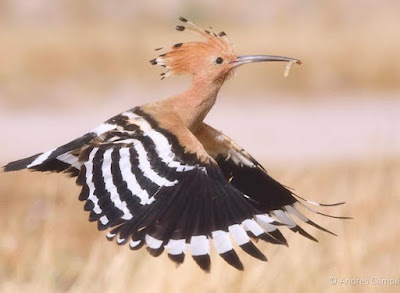
I find this interpretation a little hard to accept. First of all, the Neandertals lived there, they did not need to create a permanent map of an area that they knew as well as the proverbial back of their hand. Second, we have to flip it to read it correctly, why did they just not orient it properly in the first place? While, as I said, I find this somewhat of a stretch, I can admit that it is barely possible. I do not find it likely, but it must be accepted as a possibility. But Fowler’s next analysis goes totally over the edge for me. The Gorham’s Cave hashtag engraving is also a picture of a bird, the hoopoe.


Eurasian Hoopoe in flight. Photograph Andres-Campillo Castejon.

From Fowler, 2021, The Neanderthal “Hashtag” Engraving in Gorham’s Cave: A Possible Map of Gibraltar’s Upper Paleolithic Coastal Plain, Academia Letters, Article 3771, Figure 19, page 9.

“While that could explain the engraving of the first eight lines, the final six lines have no correlation with any known physical features detectable on the submerged plain. The manner in which they were created – each with a single stroke, suggesting rapid succession – after taking as many as 300 strokes to create the eight lines in the main engraving seems to suggest these lines had a special significance. If such pains were taken to describe ‘here’ what could these eight quick strokes signify or symbolize? Sue Davies, Head of Cultural Heritage at the Gibraltar Museum, has been quoted as remarking the entire engraving resembled a ‘stylized hoopoe’ (Upupa epops). One of the reasons for this apparent similarity are single stroke lines 9, 10 and 11, which roughly resemble an abstract hoopoe head. Line 9 serves as the peak of the upper crest and distinctive beak, while lines 10 and 11 represent the middle and front of the crest. Lines 12 and 13 would appear to be tail feathers, while the 14th and final line would have symbolized the body. When lines 9 through 14 are placed over lines 1 through 8, the similarity to the hoopoe can be clearly seen. When line 2 is removed and only the ‘body’ (line 1, where all the single stokes were applied) remains, the resemblance to the bird is striking. If the Neanderthal engraving was intended to resemble a bird, it would come as no surprise. The relationship between Neanderthals and birds, particularly at Gibraltar, is well documented. Not only is there evidence from Gorham’s cave they utilized both rock doves (pigeons) and the red billed clough(sp) as major food sources, there is confirmation they sought out birds such as black raptors and corvids solely for the purpose of obtaining their feathers.” (Fowler 2021:6-7)

I just do not know what to say about this. It is, for me, a flight of fancy too far. So, the map – unlikely, but barely possible, the hoopoe – not likely, and I will leave it at that.

NOTE: Some images in this posting were retrieved from the internet with a search for public domain photographs. If any of these images are not intended to be public domain, I apologize, and will happily provide the picture credits if the owner will contact me with them. For further information on these reports you should read the original reports at the sites listed below.

REFERENCES:

Faris, Peter, 2014, Rock Art in Gibraltar Cave Attributed to Neandertal Occupation, 27 September 2014, https://rockartblog.blogspot.com/search/label/Gibraltar

Fowler, T., 2021, The Neanderthal “Hashtag” Engraving in Gorham’s Cave: A Possible Map of Gibraltar’s Upper Paleolithic Coastal Plain, Academia Letters, Article 3771, https://doi.org/10.20935/AL3771.

Rodriguez-Vidal, Joaquin et al., 2014, A rock engraving made by Neanderthals in Gibraltar, www.pnas.org/cgi/doi/10.1073/pnas.1411529111

The Gibraltar Museum, 2015, Gibraltar Neanderthal Caves and Environments, World Heritage Site Nomination, HM Government of Gibraltar.

Sunday, May 15, 2022

S. BROWN, CO. F, 3RD I, 1859 - SIGNATURE ROCK, BOISE CITY, OK:


S. Brown, Co. F, 3rd I, 1859, Signature Rock, Boise City, Oklahoma. Photograph Peter Faris, 12 June 2006. 


Close-up of signature, S. Brown, Co. F, 3rd I, 1859, Signature Rock, Boise City, Oklahoma. Photograph Peter Faris, 12 June 2006.

Back in 2006 I visited a ranch outside of Boise City in the panhandle of western Oklahoma which has a cliff covered with old inscriptions from the Santa Fe Trail. One that interested me is “S. Brown, Co. F, 3d I, 1859,” which I take to refer to Company F of the 3rd Infantry Regiment. 

The 3rd Infantry Regiment was the U. S. Army’s first Regiment, founded in 1784, and is the oldest currently active regiment in the Regular Army. They fought in the Mexican War, after which they were assigned to New Mexico Territory. “From 1856 to 1860 the regiment served in New Mexico where it fought the Navajo Indian tribe.” (Wikipedia)


Fort Defiance, New Mexico Territory (now Arizona). Illustration Seth Eastman, 1873.

The encyclopedic, 475 page compendium of the Navajo wars and fighting by Frank McNitt (1972) provides only a few mentions of the 3rd Infantry Division, with only one mention of Company F (in 1851), and no S. Brown listed. It mentions "Lieutenant Henry B. Schroeder's Company F, Third Infantry" as being part of the garrison of Fort Defiance. (McNitt 1972:199)


Navajo family with loom. Near Old Fort Defiance, New Mexico. Albumen print photograph, 1873, public domain.

The U.S. Army Center of Military History records the following information for the 3rd during 1858. "1858 - Janyary 1 to February 11; scout against Kiowa Indians in neighborhood of Manzana; Company F, March to September; Mormon Expedition into Utah; Companies A, E and R, May 30; engagement with Navajo Indians at Ewell's hay camp near Fort Defiance; detachments of B and G. September, October and November; campaign against Navahos; engagements; September 19 to 24, Canyon de Chelly; Company G; September 25, Laguna Negra, Company B; October 1, Bear Springs, Company B; October 10 Rancho de los Anagones, Company G; November 9 near Fort Defiance, Company F." (U.S. Army Center of Military History) Their record, however, does not mention company F in 1859, it does come up again in 1860 at Fort Defiance.

During this March to September period in 1858, a confrontation accurred which is known as the Mormon Expedition. The Mormon Expedition, also known as the Utah War "or the Mormon Rebellion was an armed confrontation between Mormon settlers in the Utah Territory and the armed forces of the U.S. government. The confrontation lasted from May 1857 to July 1858. There were some casualties, most of which were non-Mormon civilians. The was had no notable military battles." (Wikipedia)

So, with the 3rd Infantry Regiment based at Fort Defiance, New Mexico, from 1856 to 1860, how did a member of the 3rd put his name on Signature Rock in Western Oklahoma in 1859. I can only assume that our S. Brown was on his way back to the States when he passed through Oklahoma, headed East on the Santa Fe Trail which passes right by that location. Was he discharged from military service, or was he sent back to deliver dispatches? I shall probably never know, but he has led me on a fascinating journey trying to trace him down.

NOTE: Some images in this posting were retrieved from the internet with a search for public domain photographs. If any of these images are not intended to be public domain, I apologize, and will happily provide the picture credits if the owner will contact me with them. For further information on these reports you should read the original reports at the sites listed below.

REFERENCES:

U. S. Army Center of Military History, Third Regiment of Military, https://history.army.mil/books/R&H/R&H-3IN.htm, accessed 12 December 2021.

McNitt, Frank, 1972, Navajo Wars: Military Campaigns, Slave Raids, and Reprisals, University of New Mexico Press, Albuquerque

Wikipedia, 3rd U.S. Infantry Regiment (The Old Guard), https://en.wikipedia.org/wiki/3rd_https://en.wikipedia.org/wiki/3rd_U.S._Infantry_Regiment_(The_Old_Guard)#1815_to_1861, accessed 13 December 2021.

Wikipedia, Utah War, https://en.wikipedia.org/wiki/Utah_War, accessed 12 December 2021.

Friday, May 6, 2022

DID WE SEE A BLACK-FOOTED FERRET AT CASTLE GARDENS, WYOMING?


Castle Gardens, Wyoming.


Location of Castle Gardens, Wyoming.

In September 1992 a group from the Colorado Archaeological Society was visiting the wonderful rock art site of Castle Gardens, Wyoming. At one point while looking at a petroglyph panel two or three of us saw a movement out of the corner of our eye, low down on the ground and to the left, which drew our attention. Looking that way we saw just a flash of a small, low (short-legged), long-bodied animal run behind a rock formation. None of us got a good enough look to see details, but, having seen weasels before my first and immediate impression was that it was a member of that family (Mustelidae). Its color was a light tan, not the darker brown of a mink or a weasel. It was also not the white of a short-tailed weasel or ermine in winter colorization (as this was September they would have still been wearing their summer coat of white neck, chest, and underbelly, and medium to dark brown elsewhere). This was definitely a light tan color.


Black-footed ferret. Internet photograph, public domain.

“The ferret was first described by John James Audubon and John Bachman in 1851 from a single specimen collected from Goshen County, Wyoming. By the mid 1900s, historical eradication campaigns, diseases, and habitat loss through cropland conversion had drastically reduced populations of prairie dogs, the primary prey species for ferrets. As prairie dogs declined, ferrets were predicted to be near extinction. In 1967, the ferret was federally listed as Endangered throughout its range in Wyoming and 11 other western and Midwestern states under the Endangered Species Act. Within 1 year of this designation, all wild ferrets from the last known population in Mellette County, South Dakota died, and by 1979 the last ferret in captivity also perished. Despite nearly a decade (1973-1981) of targeted searches throughout Wyoming and adjacent states, no other populations were found, leading many to believe that the ferret was extinct.

In 1981, a fortuitous event occurred that irrefutably saved the ferret from extinction and initiated one of the most successful wildlife conservation stories in history. On 26 September 1981, a rancher’s cattle dog brought the carcass of a weasel-like animal to the doorstep. A local taxidermist identified the species as a ferret, and soon thereafter biologists discovered a population of ferrets in the surrounding area.” (Wyoming Black-Footed Ferret Management Plan 2018:2-3)

With the rediscovery of this remaining wild population a captive-breeding program was undertaken to save the species. “A captive-breeding program launched by the United States Fish and Wildlife Service resulted in its reintroduction into eight western US states, Canada, and Mexico from 1991 to 2009.” (Wikipedia)

“In 1991, the first reintroduction site for ferrets was established at the Shirley Basin/Medicine Bow Reintroduction Site.” (Wyoming Black-Footed Ferret Management Plan 2018:4)  It seems highly unlikely that a ferret reintroduced to the wild in 1991 at the Shirley Basin/Medicine Bow Site would have appeared at Castle Gardens in September 1992 with a distance of over one hundred miles between them, so our assumption is that there were, in fact, other wild ferrets that had remained undiscovered.

“As of 2011, over 1,000 mature, wild-born individuals are in the wild across 18 populations, with four self-sustaining populations in South Dakota, Arizona, and Wyoming.” (Wikipedia) Hopefully, the future of the Black-footed ferret in the wild is now assured.


Shield petroglyph with two long, slender animals. Castle Gardens, Wyoming. Photograph Peter Faris, September 1992.


Close-up of shield petroglyph with two long, slender ferret-like animals. Castle Gardens, Wyoming. Photograph Peter Faris, September 1992.


Another shield petroglyph with two long, slender ferret-like animals. Castle Gardens, Wyoming. Photograph Peter Faris, September 1992.


Close-up of another shield petroglyph with two long, slender ferret-like animals. Castle Gardens, Wyoming. Photograph Peter Faris, September 1992.

Castle Gardens is known for its grand displays of petroglyphs, many of them shield designs. One of these has a head with horns (a horned-headdress?) flanked by two slender, long-bodied animals oriented vertically on each side, and another has two slender, long-bodied animals vertically and opposite each other without the head in between, like mirror images of each other. Without enough details to further identify these animal portrayals, their shape alone makes the possibility that they are meant to portray a weasel or ferret, a real option that must be considered. This suggests that the Ancestral Native peoples here who made the shield petroglyphs must have been familiar with the black-footed ferret, the country is the same as the environment they used to thrive in and the pictures are here.

So, the upshot of this is that we three observers are convinced that in 1992 we saw petroglyphs at Castle Gardens that portray ferrets as designs on shields, as well as seeing a live, wild black-footed ferret at Castle Gardens, a place where, and at a time when, they were supposedly extinct. Quite a memory.

NOTE: Some images in this posting were retrieved from the internet with a search for public domain photographs. If any of these images are not intended to be public domain, I apologize, and will happily provide the picture credits if the owner will contact me with them. For further information on these reports you should read the original reports at the sites listed below.

REFERENCES:

Anonymous, 2018, Wyoming Black-Footed Ferret Management Plan, 24 November 2018, Wyoming Game and Fish Commission and Black-Footed Ferret Working Group, State of Wyoming.

Wikipedia, Black-Footed Ferret, https://en.wikipedia.org/wiki/Black-footed_ferret, accessed on 1 April 2022.