Saturday, June 25, 2011

THE OLDEST ART IN AMERICA - CLOVIS ART? – THE GAULT, TEXAS, ENGRAVINGS:


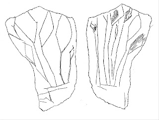
Engraved stone, Clovis, Gault, TX.
Drawing by Peter Faris after a
photograph by Michael Collins.

I have written previously on some candidates for the earliest art in North America. These were the Vero Beach, Florida, engraved bone and the Cooper, Oklahoma, painted bison skull. The Cooper painted skull has been dated to the Fremont period and the Vero Beach engraving is problematical at best.

Purposefully made markings on stone from the Clovis culture have been recovered from deposits at Gault, Texas. A number of limestone plaques or flakes have been modified or decorated with lines scratched into them. Interpretations of the lines range from maps of surrounding drainages to illustrations of plants. A number of these engraved stones have been recovered from with identifiable artifacts from a Clovis context dating to approximately 13,500 years ago.

The example illustrated was recovered in proximity to a Clovis point made from “Alibates flint”. It shows engraved lines on both sides. D. Clark Wernecke and Michael Collins examined over 100 other stones from this location with purposeful markings on them as well which they date from 13,500 B.P. to 9,000 B.P. and reported on this to the September 2010 IFRAO Congress Symposium: Pleistocene art of the Americas. Their description of this example is that it “is limestone and has a design, on both sides, that incorporates parallel lines meeting with lines terminating in diamonds. It may represent plants or, as often found in iconography elsewhere, fletched darts.”

Wernecke and Collins also reported that some artifacts and stones found at Blackwater Draw, the type site for Clovis, had incised lines on them.

This suggests that Clovis period engraved stones must be considered as strong candidates at this time for the oldest art in North America.

Reference:

WERNECKE, D. Clark and Michael B. COLLINS
2010, “Patterns and Process: Some Thoughts on the Incised Stones from the
Gault Site, Central Texas, United States”, IFRAO Congress, September 2010 – Symposium: Pleistocene art of the Americas.

Sunday, June 19, 2011

PROGRESSIVE ILLUMINATION IN CAVE ART INTERPRETATION:


Painted aurochs, Lascaux, France.

We do not know whether or not any of the painted caves in Europe were conceived of as overall complex compositions although this is one thread historically pursued in attempts to unravel the “meaning” of the painted walls and chambers in the caves. Modern analysts measure the relationship of painted images and panels in the cave in terms of their proximity and distance from other images and panels, the cave entrance, etc.
There is no one space in any of the painted caves of Europe from which one can see all of the art. In general the art is scattered in panels in various locations throughout the cave, and in some isolated figures. This is done in a search for significance in their arrangement, both the placement of panels within caves and the arrangements of elements within the panels themselves. The prehistoric artists may have bypassed locations that were easily approached for places that are (and were then) quite hard to get to. This suggests that something about specific locations was quite important, and maybe the distances between was important as well. In other words, perhaps there is a reason why this image is supposed to be a certain distance from that image.

Illuminated cave art.

A potential viewer entering the cave would then see the painted images in a certain order, moving from this image or panel to the next in sequence. Certainly, with the simple illumination of torches and animal fat lamps used originally the painted images would emerge from the dark as one approached their location, only to fade into the dark again before one moved very far away. This suggests the possibility of an integrated interpretation of the overall in the same way that a modern Hollywood movie has scenes definitely assembled into the overall plot (think of story boards), with the spacing of panels and elements serving as the equivalent of timing in the narrative, the equivalent of spacing and time within the telling of the story.

The proponents of this theory would probably point out that the imagery contained in each panel would be similar to the actors in each scene in our movie, with some actors appearing in one scene, some appearing in another, some appearing in more and others in fewer scenes, but all necessary to the overall plot of the film.

While I cannot personally believe that they were originally conceived of, and produced, as an overall complex but unified whole, I can agree to the probability that they were seen that way by later visitors. Although we know that some of the painted caves of Europe were not visited by later visitors, I am not aware of that proscription for all caves. Imagine a later visitor entering one of these caves with his own torch or fat lamp for illumination and seeing for the first time the surprising and unexpected images. This viewer would also see them in some order and would, I believe, be forced to make up a narrative to explain the images in their order. This narrative would almost surely not be the same one that the original creators would have applied to their work, but it would be as powerful and important to these later viewers as it was to the original creators. Indeed their subsequent mythology and legends would necessarily accommodate the these pictures which require explanation by their very existence. Indeed, it is quite possible that the order in which the later viewers approached the contents of the cave would necessarily be different because the entrances to these caves are known to have changed over time. A rockfall or landslide could cover up one entrance while another one is being created by erosion. We know that for many of the caves our modern entrances are definitely not the same as the ones used originally.

In the American west we find little art in caves proper but much rock art in our western canyons and a the same case can be made for its viewing and interpretation. Wouldn’t the story you come away with depend on where you started? You can enter the canyon at its mouth, its head, or perhaps find a trail to drop down somewhere along the canyon’s length. This would also affect the order in which you saw the panels.

Our ancestors may have exited prehistory and entered history carrying a cosmic view and mythology based upon memories of their ancestor’s interpretation of the illustrated caves. This means that the old stories and legends that we learn could be directly traceable back in time to the stories and legends used to explain the cave paintings and other rock art. Our myths and legends could be traceable back to roots in the painted caves of Europe, and even today we are making up our own stories to explain them.

Saturday, June 11, 2011

HAWAIIAN ROCK ART IN UTAH:

Sea turtle petroglyph, Iosepa, UT.
Photograph by Benjamin Pykles.

In the last few months I have posted comments of a number of rock art sites I visited on a trip to Hawaii. What I had never expected was the fact that I could have visited Hawaiian rock art considerably closer to my home in Colorado.
Sea turtle petroglyph, Iosepa, UT.
Drawn by Peter Faris, after a
photograph by Benjamin Pykles.

In Skull Valley, Utah, west of Salt Lake City, Benjamin Pykles of the State University of New York at Potsdam has conducted archaeological investigation of the former site of the town of Iosepa. Pykles was assisted by Jonathan Reeves, an archaeology student at SUNY Potsdam. They recorded a remarkable group of petroglyph on the slope of Salt Mountain, overlooking the site of Iosepa and they presented their findings during a Society for American Archeology conference on April 1 in Sacramento, Calif. What makes these petroglyphs remarkable is the fact that they are mostly of tropical marine themes, and were done in a very Hawaiian-looking style.
Fish petroglyph, Iosepa, UT.
Drawn by Peter Faris, after a
photograph by Benjamin Pykles.

Subjects pictured in the 26 petroglyphs are reported to include fish, sea turtles, palm trees, a whale, and even what seems to represent a jellyfish, as well as more expected images such as a jackrabbit. The town of Iosepa had been founded in 1889 by Hawaiian converts to the Mormon Church who had moved to Utah with returning Mormon missionaries and settled in the Salt Lake City area.

Richard Poulsen, the President of the Iosepa Historical Society described the founding of the town in http://www.kued.org/productions/polynesian/history/.

“In the late 1800's the Mormon Church was expanding rapidly around the world due to the dedicated efforts of many diligent missionaries. Church membership grew especially fast in the Hawaiian Islands, where the native Polynesian people were quick to embrace the teachings of the gospel. Many of these Hawaiian converts felt a strong desire to come to Zion, where they could do temple work for themselves and for their ancestors. Soon arrangements were being made to undertake the journey, and these members began trickling into Utah as they accompanied missionaries returning to Utah from the Sandwich Islands. These pioneers settled into the Salt Lake Valley and its surrounding areas.


In 1889 a group of three Hawaiian converts and three return missionaries chose a section of land on Skull Valley's Rich Ranch for the purpose of forming a colony of Polynesian Saints. This colony was called Iosepa, the Hawaiian equivalent of Joseph, in honor of Joseph F. Smith, who had served a mission in the Hawaiian Islands.


On August 28, 1889, these Polynesian Saints moved to Iosepa, where lots were drawn for plots of land that had room for a home, garden, barn and corral. A sawmill was purchased and the Polynesians built homes, a chapel/assembly hall, a school, and a store in their community.”


The town developed steadily, and, with irrigation, became a thriving oasis in the Utah desert. The population grew to 228 souls and it was considered to be one of the great success stories in the colonization efforts of the church. Plantings thrived and included 300 walnut trees, 300 fruit trees, over 100 ornamental trees, grass, grape vines berries and flowers, especially noted were its yellow roses (Poulsen).

Poulsen continued “In 1915, Joseph F. Smith, then president of the Mormon Church, announced plans to build a temple at Laie, on the North Shore of Oahu. Some of the Hawaiians decided to return to the Islands, where they would now have more opportunities to perform sacred ordinances than they did in Utah, since the temple in Salt Lake City was 75 miles away. Church officials did not advise the colonists as a group to return, but did offer financial assistance to those who needed it. All of this had a snowballing effect, with more and more families deciding to return to Hawaii. Soon, even those who wished to remain in Iosepa were uncertain of the town's future. By January 1917, the town was virtually abandoned.”

Although these have to be considered historic (not prehistoric) images there is apparently no record of their purpose or any possible meaning. They may have been an appeal to remembered ancestral spirits to watch over the settlement, or perhaps just a vestige of homesickness on the part of one of the colonists. In any case, the petroglyphs of Iosepa are a record of a fascinating historical episode.

Reference:
http://www.kued.org/productions/polynesian/history/


Saturday, June 4, 2011

A HISTORIC INSCRIPTION - James Ragen, Co. H, 2nd CO. CAV, Apr.20, ‘65:

James Ragen inscription, Bent's New Fort, CO.
Photo - Bill McGlone.

This inscription is carved on the cliff along the Arkansas River near the site of Bent’s New Fort, located a few miles downriver from Bent’s Old Fort. In the late 1840s Indian troubles caused a decline in trade, which made Bent’s business unsustainable. Wm. Bent attempted to sell it to the army but they would not meet his price so in 1849 he blew the fort up. In 1853 Bent built a new stone fort to the east of the old fort in what is now Prowers County, Colorado. In 1860, Fort Wise was established by the US Army one mile west of the site of Bent’s New Fort and in 1861 its name was changed to Fort Lyon. William Bent left his new stone fort and rented it to the army as a storage depot. He retired to a farm at Boggsville, along the Purgatory River. Unfortunately Fort Lyon had been built too near the river and in early 1865 a spring ice dam on the Arkansas River backed the river up and flooded the buildings. The fort was moved to a new site near Las Animas in Bent County, Colorado in 1865.

Old Fort Lyon, fr. Hyde, The Life of Geo. Bent, 1968.

The Second Colorado Cavalry was organized in October 1863, in St. Louis, MO, by consolidation of the 2nd and 3rd Infantry Regiments. James Ragen enlisted with the rank of Private and was assigned to Company H. Companies F, G, H, and K, were on duty in Colorado at Fort Lyon and other points until November 1863. “Company K stayed at Fort Lyon till the month of November; then Companies F, G, and H of the Third Regiment, in obedience to general order, concentrated with Company K of the Second at Fort Lyon and received orders to march for the States. Accordingly, on the twentieth day of November, 1863, with Major Pritchard in command, we started at noon and made about twelve miles.” While Company K of the Second Colorado was crossing the Plains the rest of the regiment, including Company H which was already on duty in Arkansas, received orders to march to Kansas City preparatory to consolidation. Another trooper in Company H of the Second Colorado Cavalry was John Johnson, otherwise known as “liver-eating” Johnson, the notable mountain man and the model for the character of Jeremiah Johnson in the movie of the same name.

Lt. Col. Theodore Dodd (L.) and Col. James H. Ford (R.),
photo archived at Carlisle Barracks.

“The first and only colonel of the regiment was James H. Ford, Theodore Dodd was the lieutenant colonel. At the time of the consolidation Company A of the 2nd Colorado Cavalry (Dodd’s former company) became Company B of the 2nd Colorado Cavalry. Company B of the 2nd Colorado Infantry (originally Ford’s Independent Company) became Company A of the 2nd Colorado Cavalry.” In January, 1864, the 2nd Colorado Cavalry was ordered into the Missouri border counties to fight against Confederate “bushwhackers” and in October, 1864, was part of the Union force raised to repel the Missouri invasion of Confederate General Sterling Price. When he withdrew, the 2nd Colorado Cavalry joined the pursuit, meeting his forces for the last time near Fayetteville, Arkansas, in November 1864.

In December 1864 they were moved to Fort Leavenworth, Kansas, where Colonel Ford, with the Brevet rank of Brigadier General, commanded the military district of the Upper Arkansas. The 2nd Colorado Cavalry was largely devoted to escorting supply and wagon trains, and occasionally skirmishing with Indians. At Fort Riley, Kansas, there were eight companies of the 2nd Colorado, accompanied by one section of the 9th Wisconsin Artillery. Two companies of the 2nd Colorado were also stationed at Fort Larned with one company of the 12th Kansas Cavalry, one company of the 11th Kansas Cavalry, and one section of the 9th Wisconsin Artillery. On December 31, 1864, Col. Ford had 24 officers and 803 men present, able for duty, and in the saddle. Of course, there were many not in the saddle.

The last troops of the 2nd Colorado Cavalry were mustered out in September 1865 leaving this inscription as a tangible record of the events. It reminds us of the history of the area, and gives us a peek into the complicated stories of the early years of American settlement of the West.