Saturday, March 12, 2016
MAPS IN ROCK ART - REVISITED:
"Map Rock", Turkey Creek, Fort
Carson, Colorado. Photograph:
Peter Faris, July 2005.
On April 18, 2009, I posted a column titled "ARE THERE MAPS IN NATIVE AMERICAN ROCK ART?" In this column I presented a so-called
map panel petroglyph from southeastern Colorado and explained my belief that it
could not represent a map as we define the term.
A fairly simple illustration of this question is found at
the so-called "Map Rock" at Turkey Creek, Fort Carson, Colorado,
pictured above. The most common explanation of any so-called map rocks is that they picture the landscape
around the site. The lines are matched up to water courses or valley bottoms
for explanation.
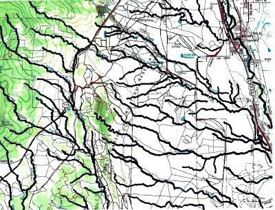
As you can see I have done this for the Turkey Creek map
rock. The first step was to trace the lines on the rock.
Map of Fort Carson, Colorado. The
Turkey Creek area is in the bottom
left quadrant.
Tracing of the watercourses on
the Fort Carson map.
Then I traced the
streams and waterways on a map of the Turkey Creek area at Fort Carson. It is a
relatively simple step then to compare the tracings for commonalities that
would identify the petroglyph as a map. "But what about scale" you
say? I think we can see that there is no grouping of lines on the map tracing
that matches the petroglyph at any scale.
"Ah, but what if it is a map of trails, not
streams?" There I have to fall back on my previous explanations. I do not
believe that Native Americans ever created what we identify as a map to record
trails. First, you do not need a map to follow most trails, you can see them
clearly there on the ground, and this map is not going to fit into your pocket
anyway. Then the map proponents declare that it is a "secret trail"
that will take the people to safety in a time of war. Some secret! If that were
the case their secret is posted on the equivalent of a billboard for their
enemy to find and follow.
Lean Wolf's ledger book drawing
of his horse raid. From Warhus,
1997.
About the closest I can come to acknowledging a map in
Native American art would be an example from ledger art that shows a figure
traveling a route for a horse raid (Warhus 1997). That is the map drawn by Lean
Wolf, 1881, recording, and advertising, his heroism, but that is not intended
to accurately portray the geographic details of the route, it is intended to be
a record of Lean Wolf's deeds and actions, his personal history. This was also drawn during the period when Anglo culture was changing the native practices, and so is strongly influenced by American culture.
So, in the end, I fear I have to stick with my opinion that
there just are no maps in rock art. If you believe otherwise please send me the
evidence.
Faris, Peter
http://rockartblog.blogspot.com/2009/04/are-there-maps-in-native-american-rock.html
Warhus, Mark
1997 Another America: Native American Maps and
the History of Our Land, St. Martins Press, New York.
Labels:
Colorado,
Fort Carson,
Lean Wolf,
maps,
petroglyph,
rock art,
Turkey Creek
Subscribe to:
Post Comments (Atom)


No comments:
Post a Comment